St. Catharines is the most populous city in Canada's Niagara Region, the eighth largest urban area in the province of Ontario. As of 2017, St. Catharines has an area of 96.13 square kilometres (37.12 sq mi) and 140,370 residents. It lies in Southern Ontario, 51 kilometres (32 mi) south of Toronto across Lake Ontario, and is 19 kilometres (12 mi) inland from the international boundary with the United States along the Niagara River. It is the northern entrance of the Welland Canal. Residents of St. Catharines are known as St. Catharinites. St. Catharines carries the official nickname "The Garden City" due to its 1,000 acres (4 km2) of parks, gardens, and trails.
Welland is a city in the Regional Municipality of Niagara in Southern Ontario, Canada. As of 2021, it had a population of 55,750.

Thorold is a city in Ontario, Canada, located on the Niagara Escarpment. It is also the seat of the Regional Municipality of Niagara. The Welland Canal passes through the city, featuring lock 7 and the Twin Flight Locks.
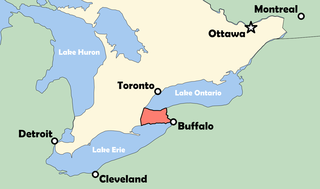
The Niagara Peninsula is an area of land lying between the southwestern shore of Lake Ontario and the northeastern shore of Lake Erie, in Ontario, Canada. Technically an isthmus rather than a peninsula, it stretches from the Niagara River in the east to Hamilton, Ontario, in the west. The peninsula is located in the Golden Horseshoe region of Southern Ontario, and has a population of roughly 1,000,000 residents. The region directly across the Niagara River and Lake Erie in New York State is known as the Niagara Frontier.

The Regional Municipality of Niagara, also colloquially known as the Niagara Region or Region of Niagara, is a regional municipality comprising twelve municipalities of Southern Ontario, Canada. The regional seat is in Thorold. It is the southern end of the Golden Horseshoe, the largest megalopolis in Canada.
King's Highway 58, commonly referred to as Highway 58, is a provincially maintained highway in the Canadian province of Ontario. The route is divided into two segments with a combined length of 15.5 km (9.6 mi). The southern segment travels from Niagara Regional Road 3, formerly Highway 3, in Port Colborne, to the Highway 58A junction in the southern end of Welland, a distance of 7.2 km (4.5 mi). The northern segment begins at Highway 20 near Allanburg and travels north and west to a large junction with Highway 406 at the St. Catharines – Thorold boundary, a distance of 8.3 km (5.2 mi). An 18.1 km (11.2 mi) gap separates the two segments within Welland and Pelham. The entire route is located within the Regional Municipality of Niagara.
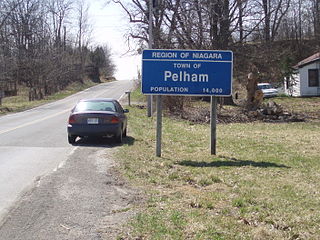
Pelham is a town located in the centre of Niagara Region in Ontario, Canada.
Fonthill is a community in the town of Pelham, Ontario, Canada. It has a few small industries, but is primarily a residential suburb with some fruit orchards, nature trails, and neighbourly attitude. As a bedroom community, most residents commute to Welland, St. Catharines and some as far as Buffalo, Hamilton and Toronto daily for work.

Welland County is a historic county in the Canadian province of Ontario.
Lincoln was a federal electoral district represented in the House of Commons of Canada from 1867 to 1883 and from 1904 to 1997. It was on the Niagara Peninsula in the Canadian province of Ontario. At various times, there was also an electoral district of the same name used in provincial elections.

Niagara Centre is a federal electoral district in the Niagara Region of Ontario that has been represented in the House of Commons of Canada from 1867 to 1988 and since 1997.
Cooks Mills is a small community in the easternmost part of the city of Welland in Ontario, Canada. It was established, and is still centred, on a Welland River tributary called Lyons Creek. It is almost entirely a bedroom community, as there are few employers located in the area.

The District School Board of Niagara is a school board in the public school system of Ontario, Canada, in the Regional Municipality of Niagara. Its head office is in St. Catharines. The DSBN operates schools in each of the twelve municipalities in the region. It employs close to 2,500 instructional staff to teach over 43,000 students in 97 elementary schools and 18 secondary schools. As of 2018, it was considered the top employer by number of employees in the Niagara Region. DSBN offers high school level courses online through Desire2Learn (D2L).
Lake Gibson is a lake near Thorold in the Regional Municipality of Niagara, Ontario, Canada. The lake is not natural, but rather was created as a reservoir for hydroelectric power generation at the Ontario Power Generation Decew Falls 1 and Decew Falls 2 generating stations. The lake was created by flooding the shallow valley of Beaverdams Creek. Lake Moodie is located to the northwest of Lake Gibson and is a smaller segment of the overall Lake Gibson system. Almost all of the water supply to these lakes comes from Lake Erie via the Welland Canal. The lakes form part of the Twelve Mile Creek watershed.
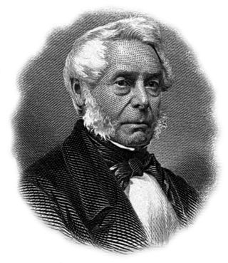
William Hamilton Merritt was a businessman and politician in the Niagara Peninsula of Upper Canada in the early 19th century. Although he was born in the United States, his family was Loyalist and eventually settled in Upper Canada. Merritt fought in the War of 1812, was captured by the invading American forces, and held as a prisoner of war. After the war, he returned to the Niagara region and began a career in business. He was one of the founders of the Welland Canal. He was a supporter of the Abolitionist cause to end slavery in the U.S., and of the settlement of escaped slaves in St. Catharines.

Effingham is a hamlet on 12 Mile Creek, in the northern part of the Town of Pelham in Ontario, Canada. Located on the Niagara Escarpment, it has few roads which wind through the Escarpment's forests.
The Raid on Short Hills was an incursion and attack by the Hunter Patriots on the Niagara Peninsula during the Upper Canada Rebellion.
Twelve Mile Creek is a waterway located on the Niagara Peninsula in the Regional Municipality of Niagara in Southern Ontario, Canada. Its headwaters are located in the town of Pelham, encompassing some of the most unspoiled and natural areas of Niagara area. The creek's lower reaches flow through urban areas of Thorold and St. Catharines and has been heavily altered by human activity for almost two centuries. The creek was first known as "Ashquasing" by the Mississaugas Indigenous people, the name meaning "that which lies at the end" in the Anishinaabe language.
John DeCew (1766–1855), was a United Empire Loyalist, an early settler in the Niagara Peninsula of Upper Canada, a commissioned militia officer in the War of 1812, and a founding member of the Welland Canal Company.

Morningstar Mill is a 2.98-acre (1.21 ha) heritage site located in St. Catharines, Ontario, Canada. The site includes the Morningstar Mill, a sawmill, the home of the Morningstar family, a barn used for blacksmith demonstrations, and the Decew Falls gorge along the Niagara Escarpment. The site is operated by the volunteer group Friends of Morningstar Mill and owned by the City of St. Catharines. The gristmill was restored to working condition in 1992.