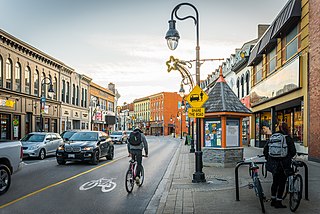
Twelve Mile Creek (Ontario)

Last updated
Twelve Mile Creek
Canada Ontario relief location map.jpg
Red pog.svg
Location of the mouth of the creek in Ontario
Location
Country Canada
Province Ontario
Region Southern Ontario
Regional municipality Niagara
Physical characteristics
SourceUnnamed pond
  location Pelham
  coordinates 43°02′59″N79°17′16″W / 43.04972°N 79.28778°W / 43.04972; -79.28778
  elevation194 m (636 ft)
Mouth Martindale Pond
  location
St. Catharines
  coordinates
43°10′43″N79°16′21″W / 43.17861°N 79.27250°W / 43.17861; -79.27250 Coordinates: 43°10′43″N79°16′21″W / 43.17861°N 79.27250°W / 43.17861; -79.27250
  elevation
85 m (279 ft)
Basin size178 km2 (69 sq mi)
Basin features
River system Great Lakes Basin

Twelve Mile Creek is a waterway located on the Niagara Peninsula in the Regional Municipality of Niagara in Southern Ontario, Canada. [1] Its headwaters are located in the town of Pelham, encompassing some of the most unspoiled and natural areas of Niagara area. The creek's lower reaches flow through urban areas of Thorold and St. Catharines and has been heavily altered by human activity for almost two centuries. The creek was first known as "Ashquasing" by the Mississaugas Indigenous people, the name meaning "that which lies at the end" in the Anishinaabe language. [2]

Contents

Watershed description

Twelve Mile Creek is named because its outlet to Lake Ontario is located approximately 12 miles (19 km) from the Niagara River. It drains a watershed of approximately 178 square kilometres (69 sq mi). This may be grouped into six sub-watersheds: [3]

Of these, only the Upper Twelve Mile Creek can truly be considered to retain any significant degree of its natural state. This sub-watershed branches out into dozens of small streams and drains flowing through Short Hills Provincial Park and St. John's Conservation Area, as well as various natural, agricultural and lightly developed areas. The area containing the headwaters is known as the Fonthill Kame Delta Complex and was formed from debris left behind by glaciers as they retreated approximately 12,000 years ago. This area has the highest elevation, and contains the only identified cold water streams identified in the Niagara region. [3] The area provides habitat for many bird species, including the Acadian flycatcher, hooded warbler, Louisiana waterthrush and Kentucky warbler. [4]

The Decew Falls, Niagara Escarpment, St. Catharines Decew Falls.JPG
The Decew Falls, Niagara Escarpment, St. Catharines

Lake Gibson is not a natural feature, but rather an artificially created reservoir. Township maps from the latter half of the 19th century show a meandering stream flowing through this area (Beaverdams Creek) and plunging over the Niagara Escarpment at Decew Falls. [5] This is the site of Morningstar Mill (still in existence today) which used this stream for power. This stream was subsequently dammed to provide a reservoir for hydroelectric generation at the Decew Falls Generation Station. The landscape was further altered with various channels and canals to improve flow to the generating station, and with the creation of additional reservoirs. Lake Gibson receives almost all of its water supply from Lake Erie via the Welland Canal. [3] This reservoir also serves as the domestic water supply for the City of St Catharines. [6]

Richardson Creek flows through mostly agricultural, but rapidly urbanizing land in the western part of St. Catharines. It is about 10.5 km (6.5 mi) in length. It combines with Francis Creek and empties into the Twelve Mile Creek at Martindale Pond, very close to its outlet. [3] These two sub-watersheds therefore do not contribute to water flow on the great majority of the Twelve Mile Creek.

Highway 406 curves over Twelve Mile Creek in St. Catharines. Lonely S (18976521999).jpg
Highway 406 curves over Twelve Mile Creek in St. Catharines.

The Dicks Creek sub-watershed originates near the escarpment in a residential area, but afterwards flows into industrial and commercial areas. It flows through the abandoned second Welland Canal, passing through the stone locks which once carried ships, before entering a tunnel. It emerges from the tunnel and joins with the main branch of the Twelve Mile Creek immediately beside Highway 406, and not far from the downtown buildings of St. Catharines. [3]

The lower portion of Twelve Mile Creek, while historically navigable as part of the second Welland Canal, is now a fast flowing river with rapids and a wide, swift water course. Almost all of the water (98 to 99%) in this portion of the creek is from the Welland Canal by way of the Decew Falls generating stations. [3] The creek empties into Martindale Pond, a small artificial lake near the shores of Lake Ontario created to permit navigation on the first Welland Canal. This body of water also served as the route for the second and third canals and remains of locks from the second and third canals are still visible. Martindale Pond is now the site of the Royal Canadian Henley Regatta course. The water flows over a weir into Port Dalhousie harbour, and finally out into Lake Ontario between two long piers.

The early Welland Canal

Aerial photo of the mouth of Twelve Mile Creek at Port Dalhousie, showing locks from the second canal (right) and third canal (left) Welland canal a030556.jpg
Aerial photo of the mouth of Twelve Mile Creek at Port Dalhousie, showing locks from the second canal (right) and third canal (left)

In the period following the War of 1812, assorted mills made use of water power from various creeks which flowed over Niagara Escarpment. Among these was a sawmill and a grist mill on Twelve Mile Creek owned by William Hamilton Merritt. Merritt's mills were plagued by low water conditions, especially in late summer - exactly when the grain harvest needed to be ground. He conceived of an idea to divert water from the Welland River to augment the water supply. The idea of a navigable canal across the Niagara Peninsula had come up in the past and it did not take long before Merritt's idea was expanded to include such a navigable waterway. [7] [8] In spite of initial plans, the water source for the canal was initially the Grand River via the Feeder Canal, as opposed to the Welland River. The modern canal receives its water directly from Lake Erie. [8] Twelve Mile Creek was not necessarily the best route for the canal, but it was the location of Merritt's mills, so economic motivation became a factor. Ultimately, the first two Welland Canals were routed via Twelve Mile Creek. The third bypassed most of the creek, but continued to use its outlet to Lake Ontario.

Early maps show that the creek meandered greatly in its lower reaches. These meanders were flooded by means of a dam at Port Dalhousie, Ontario to create Martindale Pond. [9] Further upstream, the first canal generally followed the bends in the creek, but most were straightened for the second canal resulting in the lower creek now being almost straight. [8]

Hydroelectric development

Just as water once powered mills directly, it continues to power industrial and domestic uses through generation of electricity. On a significantly smaller scale than the nearby Niagara Falls generating stations, the two DeCew Falls stations take their water supply from the Lake Gibson system, which is in turn fed mainly from Lake Erie via the Welland Canal. The DeCew Falls 1 station was originally put into service in 1898 and produces 23MW of power. [10] The DeCew Falls 2 station has been in service since 1943 (unit 1) and 1948 (unit 2) and produces 144MW of power. [11] Water from these plants is discharged into the lower Twelve Mile Creek.

Current state of the creek

A boardwalk in Mel Swart Park along the shore of Lake Gibson is one example of the recreational use of the Twelve Mile Creek watershed. MelSwartPark.jpg
A boardwalk in Mel Swart Park along the shore of Lake Gibson is one example of the recreational use of the Twelve Mile Creek watershed.

Large segments of Twelve Mile Creek are available for public access. Walking and cycling trails line most of the lower creek. [12] Short Hills Provincial Park and St. John's Conservation Area provide both conservation and public access to the creek's upper reaches. Parks and trails are present in several areas around Lake Gibson and the Bruce Trail crosses the upper portion of the watershed. Historic sites such as Morningstar Mill and remnants of the early Welland Canals are preserved and accessible.

The creek, however, is facing challenges from increasing urbanization and from agricultural, industrial and domestic pollution. The lower reaches are not in anything resembling a natural state, having been straightened, dredged and fed massively increased water flows. Dick's Creek flows through old stone locks and, in some areas, in tunnels. Other tributaries flow through flood control channels. [3] Similarly, the Lake Gibson system bears little resemblance to Beaverdams Creek which once flowed through this area. [5]

Twelve Mile Creek is a study in contrasts - in some areas, one of the most natural, and in other areas, one of the most altered watersheds in Niagara.

See also

Related Research Articles

St. Catharines City in Ontario, Canada

St. Catharines is the largest city in Canada's Niagara Region and the sixth largest urban area in the province of Ontario. As of 2016, it has an area of 96.13 square kilometres (37.12 sq mi), 133,113 residents, and a metropolitan population of 406,074. It lies in Southern Ontario, 51 kilometres (32 mi) south of Toronto across Lake Ontario, and is 19 kilometres (12 mi) inland from the international boundary with the United States along the Niagara River. It is the northern entrance of the Welland Canal. Residents of St. Catharines are known as St. Cathariners. St. Catharines carries the official nickname "The Garden City" due to its 1,000 acres (4 km2) of parks, gardens, and trails.

Welland City in Ontario, Canada

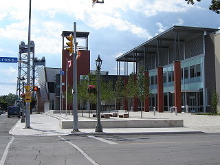
Welland is a city in the Regional Municipality of Niagara in Southern Ontario, Canada. In 2016, it had a population of 52,293.

Thorold City in Ontario, Canada

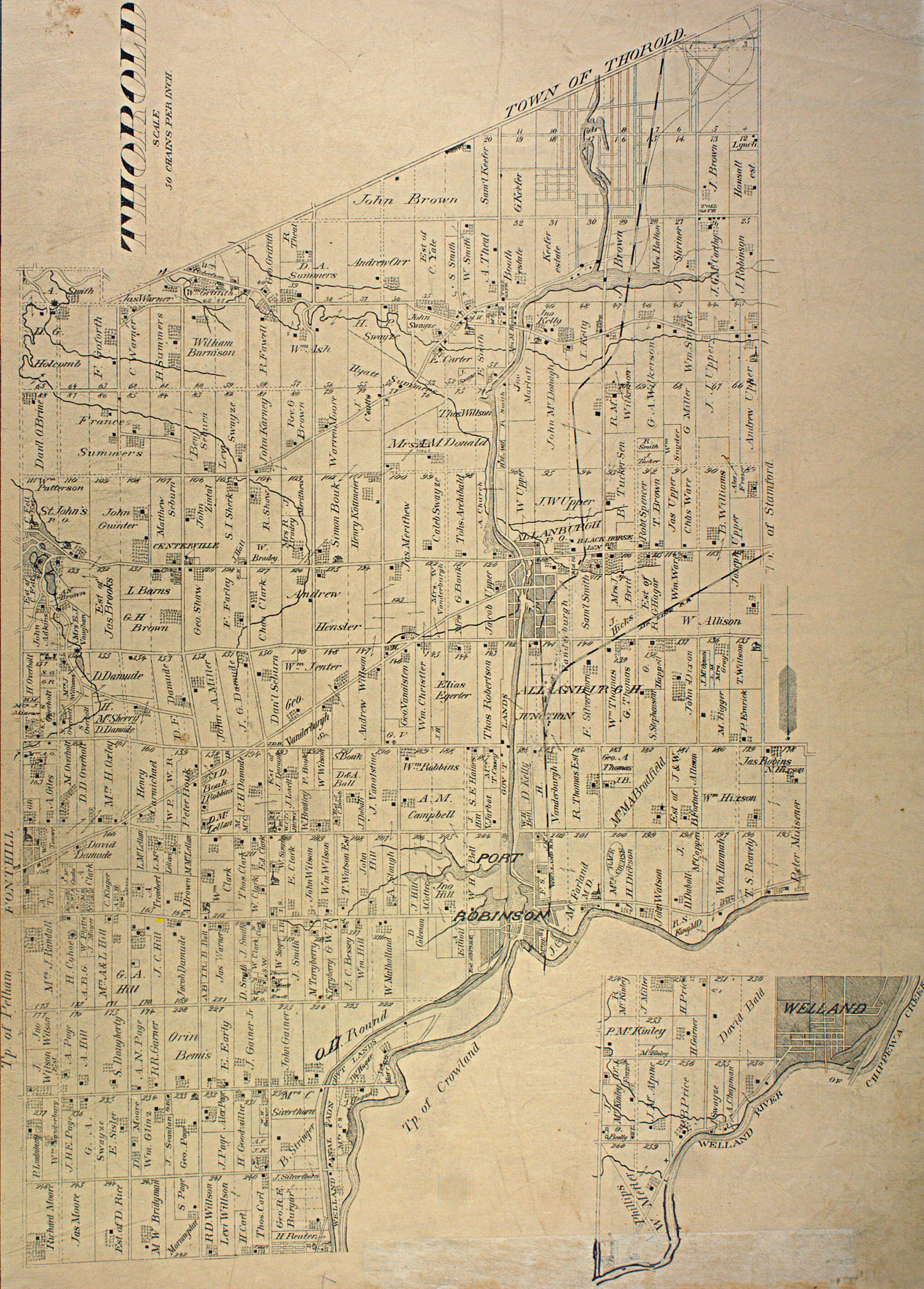
Thorold is a city in Ontario, Canada, located on the Niagara Escarpment. It is also the seat of the Regional Municipality of Niagara. The Welland Canal passes through the city, featuring lock 7 and the Twin Flight Locks.

Welland Canal Ship canal in Ontario, Canada, connecting Lake Ontario and Lake Erie

The Welland Canal is a ship canal in Ontario, Canada, connecting Lake Ontario and Lake Erie. It forms a key section of the St. Lawrence Seaway and Great Lakes Waterway. Traversing the Niagara Peninsula from Port Weller in St. Catharines to Port Colborne, it enables ships to ascend and descend the Niagara Escarpment and bypass Niagara Falls. It is the fourth canal connecting these waterways; three smaller predecessors also bore the same name.

Niagara Peninsula Peninsula in Ontario, Canada

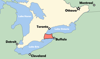
The Niagara Peninsula is an area of land lying between the southwestern shore of Lake Ontario and the northeastern shore of Lake Erie, in Ontario, Canada. Technically an isthmus rather than a peninsula, it stretches from the Niagara River in the east to Hamilton, Ontario, in the west. The peninsula is located in the Golden Horseshoe region of Southern Ontario, and has a population of roughly 1,000,000 residents. The region directly across the Niagara River and Lake Erie in New York State is known as the Niagara Frontier.

Regional Municipality of Niagara Regional municipality in Ontario, Canada

The Regional Municipality of Niagara, also colloquially known as the Niagara Region or Region of Niagara, is a regional municipality comprising twelve municipalities of Southern Ontario, Canada. The regional seat is in Thorold. It is the southern end of the Golden Horseshoe, the largest megalopolis in Canada.

Chippawa is a community located within the city of Niagara Falls, Ontario.

Welland River River in Southern Ontario

The Welland River is a river in the Golden Horseshoe that passes through the Southern Ontario cities of Welland and Niagara Falls. It flows from its source just south of Hamilton, Ontario to meet the Niagara River.

King's Highway 406, commonly referred to as Highway 406, is a 400-series highway in the Canadian province of Ontario. The primary north-south route through the central portion of the Niagara Peninsula, Highway 406 connects Welland, Thorold and downtown St. Catharines to the Queen Elizabeth Way (QEW).

Cooks Mills, Welland Unincorporated community in Ontario, Canada

Cooks Mills is a small community in the easternmost part of the city of Welland in Ontario, Canada. It was established, and is still centred, on a Welland River tributary called Lyons Creek. It is almost entirely a bedroom community, as there are few employers located in the area.

Lake Gibson (Ontario) Body of water

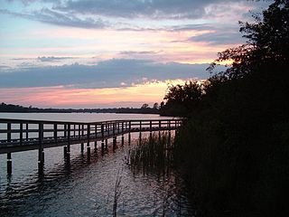
Lake Gibson is a lake near Thorold in the Regional Municipality of Niagara, Ontario, Canada. The lake is not natural, but rather was created as a reservoir for hydroelectric power generation at the Ontario Power Generation Decew Falls 1 and Decew Falls 2 generating stations. The lake was created by flooding the shallow valley of Beaverdams Creek. Lake Moodie is located to the northwest of Lake Gibson and is a smaller segment of the overall Lake Gibson system. Almost all of the water supply to these lakes comes from Lake Erie via the Welland Canal. The lakes form part of the Twelve Mile Creek watershed.

St. Johns, Ontario Unincorporated rural community in Ontario, Canada

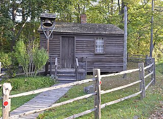
St. Johns is an unincorporated rural community in Thorold, Niagara Region, Ontario, Canada.

William Hamilton Merritt Upper Canada businessman and politician

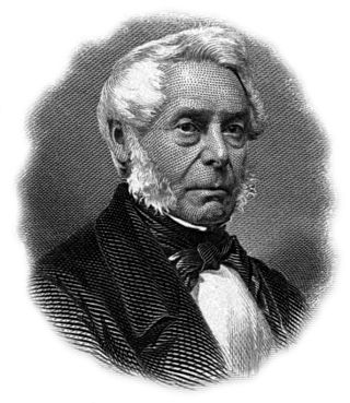
William Hamilton Merritt was a businessman and politician in the Niagara Peninsula of Upper Canada in the early 19th century. Although he was born in the United States, his family was Loyalist and eventually settled in Upper Canada. Merritt fought in the War of 1812, was captured by the invading American forces, and held as a prisoner of war. After the war, he returned to the Niagara region and began a career in business. He was one of the founders of the Welland Canal.

First Welland Canal First phase of construction of the Welland Canal, Upper Canada (1824-29, 1831-33)

The Welland Canal has gone through many incarnations in its history. Today, five distinct canal-construction efforts are recognized. The retronym First Welland Canal is applied to the original canal, constructed from 1824 to 1829 and 1831 to 1833.

Twenty Mile Creek (Ontario) River in Ontario, Canada

The Twenty Mile Creek is a minor waterway, located in the Niagara Peninsula, Ontario, Canada. The creek is named for the location of its mouth, twenty miles (32 km) west of the Niagara River along the Lake Ontario shoreline. The Indigenous name for the Twenty Mile Creek was the Kenachdaw, which translates to Lead River.

Eighteen Mile Creek, or Eighteenmile Creek, is a tributary of Lake Ontario located entirely in Niagara County, New York in the United States. The name of "Eighteen Mile" Creek refers not to the length of the creek, but to its distance from the Niagara River to the west.

John DeCew (1766–1855), was a United Empire Loyalist, an early settler in the Niagara Peninsula of Upper Canada, a commissioned militia officer in the War of 1812, and a founding member of the Welland Canal Company.

Morningstar Mill Heritage site in St. Catharines, Ontario, Canada

Morningstar Mill is a 2.98-acre (1.21 ha) heritage site located in St. Catharines, Ontario, Canada. The site includes the Morningstar Mill, a sawmill, the home of the Morningstar family, a barn used for blacksmith demonstrations, and the Decew Falls gorge along the Niagara Escarpment.

Laura Secord Legacy Trail

Laura Secord Legacy Trail is a 32-kilometer trail as a monument to Laura Secord's journey and legacy. It includes the Laura Secord Commemorative Walk that was established in 2013. Secord embarked on a journey in June 1813 during the War of 1812 from the Secord Homestead in Queenston, Niagara-on-the-Lake to deliver a message on 22 June 1813 to Lt. James FitzGibbon at the DeCew House in Thorold, Ontario.

References

  1. "Twelve Mile Creek". Geographical Names Data Base . Natural Resources Canada . Retrieved 2012-06-11.
  2. Smith, Donald (2013). Sacred Feathers: The Reverend Peter Jones (Kahkewaquonaby) and the Mississauga Indians. University of Toronto Press. p. 49. ISBN   978-1-4426-1563-2.
  3. 1 2 3 4 5 6 7 Durley, Jennifer (2006). "Twelve Mile Creek Watershed Plan" (PDF). Welland, Ontario: Niagara Peninsula Conservation Authority. Retrieved 2008-05-16.{{cite journal}}: Cite journal requires |journal= (help)
  4. Cheskey, Edward (September 2003). "Twelve Mile Creek Headwaters Important Bird Area" (PDF). Federation of Ontario Naturalists. Archived from the original (PDF) on October 26, 2006. Retrieved 2008-05-18.{{cite journal}}: Cite journal requires |journal= (help)
  5. 1 2 "Digital Library - Thorold Township Map" . Retrieved 2008-05-18.
  6. "The Regional Municipality of Niagara - Decew Falls Water Treatment Plant Raw Water Supply Improvement Plan". Archived from the original on May 31, 2004. Retrieved 2008-05-19.
  7. "Dictionary of Canadian Biography Online - William Hamilton Merritt" . Retrieved 2008-05-18.
  8. 1 2 3 Jackson, John N. (1997). The Welland Canals and Their Communities. Toronto/Buffalo/London: University of Toronto Press. ISBN   0-8020-0933-6.
  9. "Brock University Special Collections" . Retrieved 2008-05-18.
  10. "Ontario Power generation - DeCew Falls 1" . Retrieved 2008-05-18.
  11. "Ontario Power generation - DeCew Falls 2" . Retrieved 2008-05-18.
  12. "The Regional Municipality of Niagara -Bicycling Map - 2nd Edition" . Retrieved 2008-05-19..