Sturgeon Bay

Last updated

Sturgeon Bay
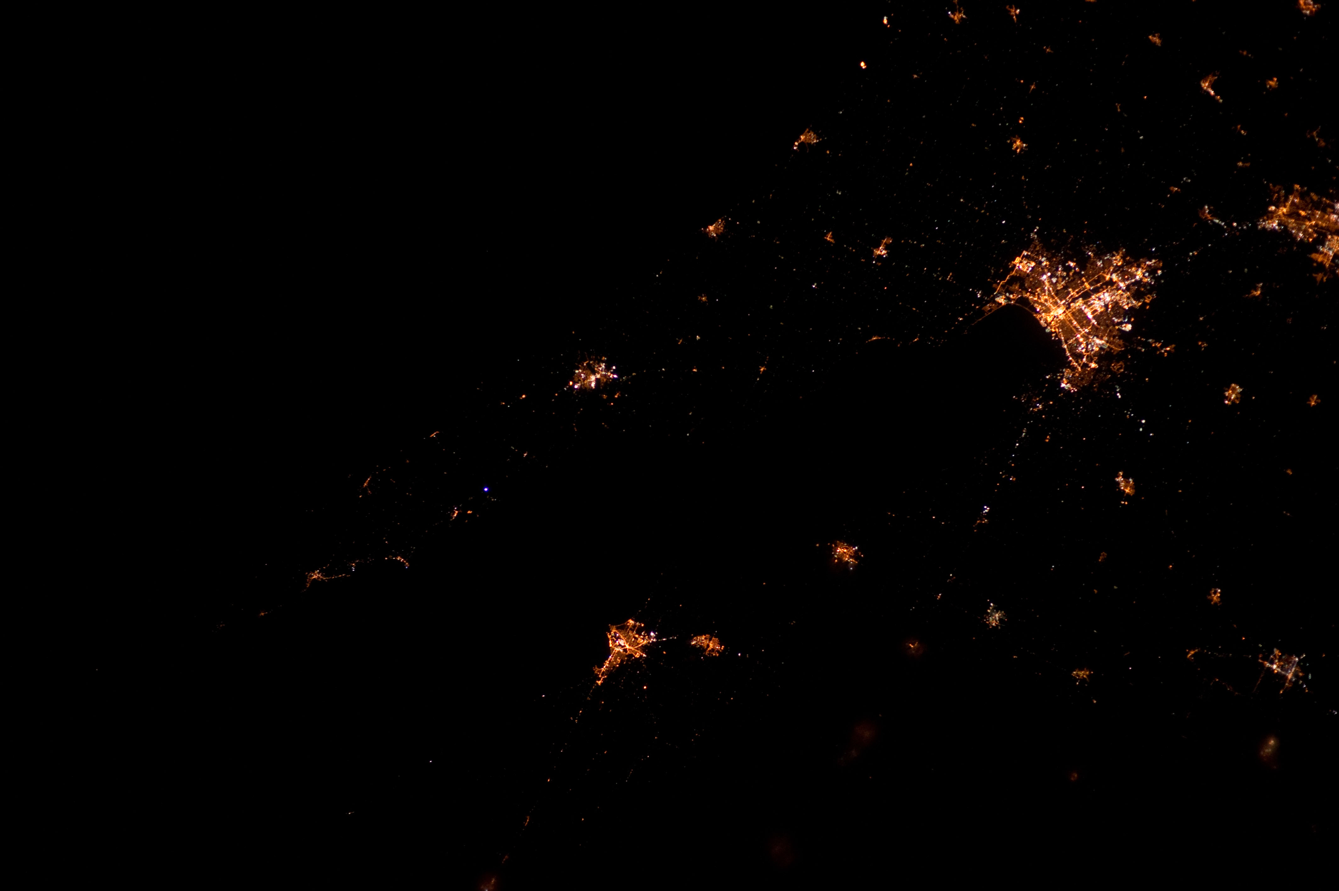
ISS011-E-15174 View of Sturgeon Bay, Wisconsin.jpg
Taken on May 16, 2005 from the International Space Station
USA Wisconsin relief location map.svg
Red pog.svg
Sturgeon Bay
Usa edcp relief location map.png
Red pog.svg
Sturgeon Bay
Location Door County, Wisconsin
Coordinates 44°51′15″N87°23′40″W / 44.85417°N 87.39444°W / 44.85417; -87.39444
Type Bay
Surface elevation581 feet (177 m)
Settlements Sturgeon Bay, Nasewaupee, Sevastopol, Idlewild

Sturgeon Bay is an arm of Green Bay extending southeastward approximately 10 miles into the Door Peninsula at the city of Sturgeon Bay, located approximately halfway up the Door Peninsula. [1] The bay is connected to Lake Michigan by the Sturgeon Bay Ship Canal. The Potawatomi name for Sturgeon Bay is "Na-ma-we-qui-tong". [2]

Contents

Origin

The bay seems to represent the pre-glacial path of the Menominee River, with the valley deepened by glacial carving and then submerged into rising lakewaters. [3]

Bridges

Three bridges cross the bay, including the historic Sturgeon Bay Bridge, and the recently finished Oregon Street Bridge.

Fish

Sturgeon Bay and Little Sturgeon (just to the south of Sturgeon Bay) are considered biodiversity hotspots because they support a large number of different fish species. [4]

Researchers collected viral hemorrhagic septicemia viruses from 184 different fish from 2003 to 2017. Two were found from 2007 to 2010 infecting smallmouth bass within Sturgeon Bay. Each of them was a different variant of a type not found in the middle or lower Great Lakes. [5]

Mayflies

In June 2016, an estimated several thousand mayflies hatched in Sawyer Bay (within Sturgeon Bay). This was the result of an experiment to stock millions of eggs from the species Hexagenia limbata and Hexagenia bilineata in the lower Green Bay area in an attempt to reintroduce the species. The last mayfly from the genus Hexagenia had been collected in the lower Green Bay area in 1955. As mayfly populations can be unstable and not all stocking locations appeared to be successful, as of 2017 it was not yet known whether it would be possible for populations of Hexagenia mayflies to become self-sustaining. [6]

Climate

Dunlap Reef (in the middle of the bay [7] )
Climate chart (explanation)
J
F
M
A
M
J
J
A
S
O
N
D
 
 
57
 
 
−6
−8
 
 
54
 
 
−8
−15
 
 
60
 
 
1
−4
 
 
129
 
 
9
−2
 
 
93
 
 
13
3
 
 
85
 
 
18
9
 
 
97
 
 
21
12
 
 
78
 
 
20
15
 
 
87
 
 
19
12
 
 
129
 
 
11
3
 
 
85
 
 
7
1
 
 
65
 
 
−2
−2
Average max. and min. temperatures in °C
Precipitation totals in mm
Source: [8]
Imperial conversion
JFMAMJJASOND
 
 
2.2
 
 
21
18
 
 
2.1
 
 
18
5
 
 
2.4
 
 
34
25
 
 
5.1
 
 
48
28
 
 
3.7
 
 
55
37
 
 
3.3
 
 
64
48
 
 
3.8
 
 
70
54
 
 
3.1
 
 
68
59
 
 
3.4
 
 
66
54
 
 
5.1
 
 
52
37
 
 
3.3
 
 
45
34
 
 
2.6
 
 
28
28
Average max. and min. temperatures in °F
Precipitation totals in inches
Mixture of ice and open water in the bay, April View of the Old Stone Quarry at George K. Pinney County Park across Sturgeon Bay from Potawatomi State Park in Door County, Wisconsin, April 26, 2014.jpg
Mixture of ice and open water in the bay, April
ISS030-E-183973.jpg
Sturgeon Bay, 1:10 AM CDT

Notes

  1. "Sturgeon Bay (Wisconsin)". Geographic Names Information System . United States Geological Survey, United States Department of the Interior.
  2. The Wisconsin Archeologist, Volume 19, No 2, page 50
  3. The Physical Geography of Wisconsin by Lawrence Martin, Bulletin Number XXXVI, Educational Series Number 4, Madison Wisconsin: Wisconsin Geological and Natural History Survey, 1916 Chapter XII: The Wisconsin Coast of Lake Michigan, page 289
  4. Kovalenko, Katya E.; Johnson, Lucinda B.; Brady, Valerie J.; Ciborowski, Jan J. H.; Cooper, Matthew J.; Gathman, Joseph P.; Lamberti, Gary A.; Moerke, Ashley H.; Ruetz, Carl R.; Uzarski, Donald G. (July 2, 2019). "Hotspots and bright spots in functional and taxonomic fish diversity". Freshwater Science. 38 (3): 480–490. doi: 10.1086/704713 . ISSN   2161-9549. S2CID   198274535.
  5. Stepien, Carol A.; Niner, Megan D. (2020). "Evolutionary trajectory of fish Piscine novirhabdovirus (=Viral Hemorrhagic Septicemia Virus) across its Laurentian Great Lakes history: Spatial and temporal diversification". Ecology and Evolution. 10 (18): 9740–9775. Bibcode:2020EcoEv..10.9740S. doi:10.1002/ece3.6611. PMC   7520192 . PMID   33005343.
  6. Evaluation of lower Green Bay benthic fauna with emphasis on re-ecesis of Hexagenia mayfly nymphs by Jerry L. Kaster, Christopher M. Groff, J. Val Klump, Danielle L. Rupp, Suneil Iyer, Ashely Hansen, Samantha Barbour, and Louisa Hall, doi.org/10.1016/j.jglr.2018.06.006, Journal of Great Lakes Research (2018), p. 14
  7. Dunlap Reef, Web-Map of Door County, Wisconsin
  8. "NASA EarthData Search". NASA. Retrieved January 30, 2016.

Related Research Articles

<span class="mw-page-title-main">Door County, Wisconsin</span> County in Wisconsin, United States

Door County is the easternmost county in the U.S. state of Wisconsin. As of the 2020 census, the population was 30,066. Its county seat is Sturgeon Bay.

<span class="mw-page-title-main">Ice Age Trail</span> Long-distance hiking trail in the United States

The Ice Age Trail is a National Scenic Trail stretching 1,200 miles (1,900 km) in the state of Wisconsin in the United States. The trail is administered by the National Park Service, and is constructed and maintained by private and public agencies including the Ice Age Trail Alliance, a non-profit and member-volunteer based organization with local chapters. It became an official unit of the National Park System in 2023.

<span class="mw-page-title-main">Green Bay (Lake Michigan)</span> Arm of Lake Michigan in Wisconsin and Michigan

Green Bay is an arm of Lake Michigan, located along the south coast of Michigan's Upper Peninsula and the east coast of Wisconsin. It is separated from the rest of the lake by the Door Peninsula in Wisconsin, the Garden Peninsula in Michigan, and the chain of islands between them, all formed by the Niagara Escarpment. Green Bay is some 120 miles (193 km) long, with a width ranging from about 10 to 20 miles ; it is 1,626 square miles (4,210 km2) in area.

<span class="mw-page-title-main">Lake Winnebago</span> Lake in Wisconsin

Lake Winnebago is a shallow freshwater lake in the north central United States, located in east central Wisconsin. At 137,700 acres, it is the largest lake entirely within the state, covering an area of about 30 miles by 10 miles with 88 miles of shoreline, an average depth of 15.5 feet, and a maximum depth of 21 feet. It has many shallow reefs along the west shore and a drop-off type shoreline on the east. There are several islands along the west shore.

<span class="mw-page-title-main">Sturgeon Bay, Wisconsin</span> City in Wisconsin, United States

Sturgeon Bay is a city in and the county seat of Door County, Wisconsin, United States. The population was 9,646 at the 2020 census. Located at the bay of Sturgeon Bay for which it is named, it is the most-populous city on the Door Peninsula, a popular Upper Midwest vacation destination.

<span class="mw-page-title-main">Wolf River (Fox River tributary)</span> Principal tributary of Fox River of Green Bay in eastern Wisconsin

The Wolf River is a 225 mi (362 km) long tributary of the Fox River in northeastern Wisconsin in the Great Lakes region of the United States. The river is one of the two National Scenic Rivers in Wisconsin, along with the St. Croix River. The scenic portion is 24 miles (39 km) long. The river and its parent the Fox River and associated lakes are known for their sturgeon which spawn every spring upstream on the lower river until blocked by the Shawano Dam. The river flows through mostly undeveloped forestland southerly from central Forest County in the north to Lake Poygan in the south. The lake is part of the Winnebago Pool of lakes fed by both the Fox and Wolf Rivers. The Fox-Wolf basin is usually considered to be a single unified basin and the rivers themselves may be referred to as the Fox-Wolf River system.

<span class="mw-page-title-main">Porte des Morts</span> Strait linking Lake Michigan and Green Bay

Porte des Morts, also known as Porte des Mortes, the Door of Death, and Death's Door is a strait linking Lake Michigan and Green Bay between the northern tip of the Door Peninsula and the southernmost of the Potawatomi Islands. At its narrowest reach between Plum Island and the peninsula, the Porte des Morts Passage is about one and one third miles across. The name is French and means "door of the dead".

In epizoology, an epizootic is a disease event in a nonhuman animal population analogous to an epidemic in humans. An epizootic disease may occur in a specific locale, more generally, or become widespread ("panzootic"). High population density is a major contributing factor to epizootics. The aquaculture industry is sometimes plagued by disease because of the large number of fish confined to a small area.

<span class="mw-page-title-main">Door Peninsula</span> Peninsula of Wisconsin in Lake Michigan

The Door Peninsula is a peninsula in eastern Wisconsin, separating the southern part of the Green Bay from Lake Michigan. The peninsula includes northern Kewaunee County, northeastern Brown County, and the mainland portion of Door County. It is on the western side of the Niagara Escarpment. Well known for its cherry and apple orchards, the Door Peninsula is a popular tourism destination. With the 1881 completion of the Sturgeon Bay Ship Canal, the northern half of the peninsula became an island.

<span class="mw-page-title-main">Sturgeon Bay Ship Canal</span> Canal across the Door Peninsula, Wisconsin

The Sturgeon Bay Ship Canal is a ship canal connecting Sturgeon Bay with Lake Michigan across the Door Peninsula in Door County, Wisconsin. A dredged channel continues through Sturgeon Bay to Green Bay. This combined waterway allows ships to sail between Lake Michigan and Green Bay without traversing the dangerous Porte des Morts strait.

<span class="mw-page-title-main">Washington Island (Wisconsin)</span> Island in Lake Michigan

Washington Island is an island of the state of Wisconsin situated in Lake Michigan. Lying about 7 miles (11 km) northeast of the tip of the Door Peninsula, it is part of Door County, Wisconsin. The island has a year-round population of 708 people according to the 2010 census. It has a land area of 60.9 km2 and comprises over 92 percent of the land area of the town of Washington, as well as all of its population. The unincorporated community of Detroit Harbor is situated on the island. It is the largest in a group of islands that includes Plum, Detroit, Hog, Pilot, Fish, and Rock Islands. These islands form the Town of Washington. Detroit Harbor bay is on the south side of the island. A large part of Washington Island's economy is based on tourism.

<span class="mw-page-title-main">Wisconsin Highway 42</span> Highway in Wisconsin

State Trunk Highway 42 is a state highway in the U.S. state of Wisconsin. It runs for 135 miles (217 km) north–south in northeast Wisconsin from Sheboygan to the ferry dock in Northport. Much of the highway is part of the Lake Michigan Circle Tour from the eastern junction with U.S. Highway 10 (US 10) in Manitowoc to its junction with WIS 57 in Sister Bay. WIS 42 parallels I-43 from Sheboygan to Manitowoc, and parallels WIS 57 throughout much of the route, particularly from Manitowoc to Sturgeon Bay, meeting the northern terminus of WIS 57 in Sister Bay.

<span class="mw-page-title-main">Viral hemorrhagic septicemia</span> Disease of fish

Viral hemorrhagic septicemia (VHS) is a deadly infectious fish disease caused by Viral hemorrhagic septicemia virus. It afflicts over 50 species of freshwater and marine fish in several parts of the Northern Hemisphere. Different strains of the virus occur in different regions, and affect different species. There are no signs that the disease affects human health. VHS is also known as Egtved disease, and the virus as Egtved virus.

<span class="mw-page-title-main">Budd Lake (Michigan)</span> Lake in the state of Michigan, United States

Budd Lake is a 175-acre (0.7 km2) lake in Clare County, in the central region of Michigan's lower peninsula.

<span class="mw-page-title-main">Potawatomi Islands</span>

The Potawatomi Islands is the most common historic name given to the string of islands that delineate the transition from Green Bay to Lake Michigan, one of the Great Lakes. The archipelago is also termed the "Grand Traverse Islands".

<span class="mw-page-title-main">Potawatomi State Park</span> State park in Wisconsin, United States

Potawatomi State Park is a 1,225-acre (496 ha) Wisconsin state park northwest of the city of Sturgeon Bay, Wisconsin in the Town of Nasewaupee. It is located in Door County along Sturgeon Bay, a bay within the bay of Green Bay. Potawatomi State Park was established in 1928.

Spring viraemia of carp, also known as swim bladder inflammation, is caused by Carp sprivivirus, also called Rhabdovirus carpio. It is listed as a notifiable disease under the World Organisation for Animal Health.

Limnoforming is the process of manipulating the physical or chemical properties of a body of water by introducing organisms which facilitate higher level biological activity, thus impacting the overall ecology of a given body of water, and eventually adjacent ecosystems.

<i>Hexagenia limbata</i> Species of mayfly

Hexagenia limbata, the giant mayfly, is a species of mayfly in the family Ephemeridae. It is native to North America where it is distributed widely near lakes and slow-moving rivers. The larvae, known as nymphs, are aquatic and burrow in mud and the adult insects have brief lives. They are often referred to as fish flies around the Great Lakes as they tend to cause the areas around water to smell like rotten fish.

<i>Hexagenia bilineata</i> Species of mayfly

Hexagenia bilineata is a species of mayfly in the family Ephemeridae. It is native to North America where it is found in the Upper Mississippi Valley. Sometimes adults of this mayfly are so abundant as to cause a nuisance because of their enormous numbers. The larvae are aquatic and burrow in mud and the adult insects have brief lives.