
Waushara County is a county located in the U.S. state of Wisconsin. As of the 2010 census, the population was 24,496. Its county seat is Wautoma.

Door County is the easternmost county in the U.S. state of Wisconsin. As of the 2020 census, the population was 30,066. Its county seat is Sturgeon Bay, making it one of three Wisconsin counties on Lake Michigan not to have a county seat with the same name. Instead it is named after the strait between the Door Peninsula and Washington Island. The dangerous passage, known as Death's Door, contains shipwrecks and was known to Native Americans and early French explorers. The county was created in 1851 and organized in 1861. Door County is a popular Upper Midwest vacation destination. It is home to a small Walloon population.

Nasewaupee is a town in Door County, Wisconsin, United States. The population was 2,061 at the 2010 census. The unincorporated community of Idlewild is located in the town, as is Sherwood Point Light and Potawatomi State Park.

Union is a town in Door County, Wisconsin, United States. The population was 880 at the 2000 census. The unincorporated communities of Shoemaker Point and Namur are located in the town.
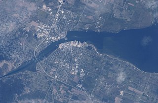
Sturgeon Bay is an arm of Green Bay extending southeastward approximately 10 miles into the Door Peninsula at the city of Sturgeon Bay, located approximately halfway up the Door Peninsula. The bay is connected to Lake Michigan by the Sturgeon Bay Ship Canal. The Potawatomi name for Sturgeon Bay is "Na-ma-we-qui-tong".
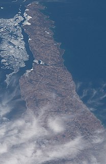
The Door Peninsula is a peninsula in eastern Wisconsin, separating the southern part of the Green Bay from Lake Michigan. The peninsula includes northern Kewaunee County, northeastern Brown County, and the mainland portion of Door County. It is on the western side of the Niagara Escarpment. Well known for its cherry and apple orchards, the Door Peninsula is a popular tourism destination. With the 1881 completion of the Sturgeon Bay Ship Canal, the northern half of the peninsula became an island.

The Sturgeon Bay Ship Canal is a ship canal connecting Sturgeon Bay with Lake Michigan across the Door Peninsula in Door County, Wisconsin. A dredged channel continues through Sturgeon Bay to Green Bay. This combined waterway allows ships to sail between Lake Michigan and Green Bay without traversing the dangerous Porte des Morts strait.

Chambers Island, named in honor of Col. Talbot Chambers, is a 2,834 acre island in Green Bay, about 7 miles (11 km) off the coast of the Door Peninsula, near Gibraltar, Wisconsin. It is part of the Town of Gibraltar in Door County.

Gills Rock is an unincorporated community located on Highway 42 at the northern tip of the Door Peninsula in Door County, Wisconsin, United States. It is within the town of Liberty Grove and was formerly known as Hedgehog Harbor.
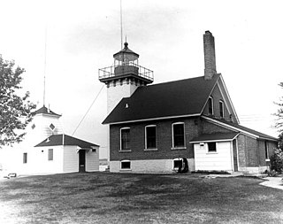
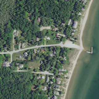
The Sherwood Point lighthouse is a lighthouse located near Idlewild in Door County, Wisconsin, United States.

Washington Island is an island of the state of Wisconsin situated in Lake Michigan. Lying about 7 miles (11 km) northeast of the tip of the Door Peninsula, it is part of Door County, Wisconsin. The island has a year-round population of 708 people according to the 2010 census. It has a land area of 60.89 km² and comprises over 92 percent of the land area of the town of Washington, as well as all of its population. The unincorporated community of Detroit Harbor is situated on the island. It is the largest in a group of islands that includes Plum, Detroit, Hog, Pilot, Fish, and Rock Islands. These islands form the Town of Washington. Detroit Harbor bay is on the south side of the island. A large part of Washington Island's economy is based on tourism.
Fish Creek is an unincorporated community located in Door County, Wisconsin, United States, within the town of Gibraltar and is located on Highway 42 along Green Bay.

Peninsula State Park is a 3,776-acre (1,528 ha) Wisconsin state park with eight miles (13 km) of Green Bay shoreline in Door County. Peninsula is the third largest state park in Wisconsin and is visited by an estimated one million visitors annually.

Whitefish Dunes State Park is a 867-acre (351 ha) state park of Wisconsin on the eastern shore of the Door Peninsula. This day-use park preserves the most substantial sand dunes on the western shore of Lake Michigan. The remains of eight successive prehistoric Native American villages are on the National Register of Historic Places as Whitefish Dunes-Bay View Site. Cave Point County Park is an enclave inside the state park, allowing visitors free foot access to the state park by the shoreline trail connecting the parks.

Cana Island is an island in Lake Michigan in the town of Baileys Harbor in Door County, Wisconsin, United States. The Cana Island Light is on the east side of the island. It is possible to walk to Cana Island from the mainland over the tombolo when water levels are low. Tombolo conditions are monitored by a webcam operated by the county parks department. The island is part of the Town of Baileys Harbor, Wisconsin.

Potawatomi State Park is a 1,225-acre (496 ha) Wisconsin state park northwest of the city of Sturgeon Bay, Wisconsin in the Town of Nasewaupee. It is located in Door County along Sturgeon Bay, a bay within the bay of Green Bay. Potawatomi State Park was established in 1928.
Whitefish Bay is an unincorporated community on the Lake Michigan shoreline in the town of Sevastopol, Door County, Wisconsin. Native Americans, likely the Menominee, called Whitefish Bay Ah-Quas-He-Ma-Ganing.

The Ridges Sanctuary is a 1,600-acre (650 ha) nature preserve and land trust in Baileys Harbor, Wisconsin. It is listed as a National Natural Landmark, Important Bird Area and Wisconsin State Natural Area. It was founded in 1937 and was the first land trust in the state.

Detroit Harbor is a bay between the southern end of Washington Island, and the northern end of Detroit Island. It is located in Washington, Door County, Wisconsin. An unincorporated community also named Detroit Harbor is found on the northern side of the bay. There are three islands inside of the bay, Snake Island, Big Susie Island, and Little Susie Island. The bay is dredged on either side to allow boats through, forming the East and West channels. Both car and passenger ferries to Washington Island go through Detroit Harbor, before they dock. The United States Coast Guard maintains operations in Detroit Harbor through the Washington Island Station. Detroit Harbor is designated as a Wisconsin State Natural Area by the Wisconsin Department of Natural Resources.

The Sister Islands are two islands in Lake Michigan. They are located in the bay of Green Bay, in the town of Liberty Grove, Wisconsin. At one point the islands were connected, but higher water levels have eroded the size of the islands. Combined, the area of the islands sits at 6 acres (2.4 ha).


