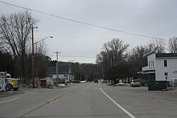
Ellison Bay, Wisconsin | |
---|---|
Coordinates: 45°15′17″N87°04′17″W / 45.25472°N 87.07139°W | |
Country | United States |
State | Wisconsin |
County | Door |
Town | Liberty Grove |
Founded | 1872 |
Area | |
• Total | 2.662 sq mi (6.89 km2) |
• Land | 2.662 sq mi (6.89 km2) |
• Water | 0 sq mi (0 km2) |
Population (2020) | |
• Total | 249 |
• Density | 94/sq mi (36/km2) |
Time zone | UTC-6 (Central (CST)) |
• Summer (DST) | UTC-5 (CDT) |
ZIP Code | 54210 |
Area code | 920 |
Ellison Bay is an unincorporated community and census-designated place in northern Door County, Wisconsin, United States, within the town of Liberty Grove and is located on Highway 42 along the Green Bay. [1] [2] As of the 2020 census, its population is 249. [3] Sur La Baie, one of Wisconsin's largest and most expensive homes, is located nearby.
A Native American name for the bay was Joe-Sahbe Bay, after a son of the Potowatomi Chief Neatoshing, who was also known as Mishicott. [4] Joe-Sahbe means "Feather of the rolling cloud". [5]
The community was founded in 1872 by John Eliasen, a Danish immigrant. [6] Lumber and fishing were important businesses in the 19th century, replaced by fruit growing in the early 20th century, and today tourism is the main business.
Gibraltar Area Schools serves the community. Gibraltar Elementary School and Gibraltar Secondary School are the two schools. [7]
This section needs expansion. You can help by adding to it. (January 2023) |
Census | Pop. | Note | %± |
---|---|---|---|
2010 | 165 | — | |
2020 | 249 | 50.9% | |
U.S. Decennial Census [8] |
Important attractions include The Clearing, a private center for adult education that was originally established by Jens Jensen, a prominent landscape architect. It is listed on the National Register of Historic Places. Other attractions include the Mink River four miles south, Turtle Ridge Gallery, [9] a cooking school, former Church turned Asian art gallery turned coffee shop, and pottery studios. Local restaurants in Ellison Bay are the Viking Grill, home to one of Door County's oldest fish boils, and the Wickman House, a restaurant featuring local produce.
Ellison Bluff County Park includes a scenic hiking trail, a picnic area, and a fenced catwalk. The bluff area has wildflowers and trees. One cedar was found to be over 250 years old. [10] Rough-winged swallows hunt for insects along the bluff. Other birds seen at the park include American redstart, great-crested flycatcher, broad-winged hawk, wood thrush, scarlet tanager, yellow-throated vireo, and pileated woodpecker. [11] 170 acres of the park is protected as the Ellison Bluff State Natural Area. [12]
On July 10, 2006, an explosion leveled the 136-year-old Pioneer Store, killing two vacationers and injuring 13 others. The blast also burned down one cottage and damaged another. It is believed a propane gas leak caused the explosion, which may have resulted from a contractor damaging unmarked underground propane lines. [13]
|
Manitowoc County is a county in the U.S. state of Wisconsin. As of the 2020 census, the population was 81,359. Its county seat is Manitowoc. The county was created in 1836 prior to Wisconsin's statehood and organized in 1848. Manitowoc County comprises the Manitowoc, WI Micropolitan Statistical Area.
Door County is the easternmost county in the U.S. state of Wisconsin. As of the 2020 census, the population was 30,066. Its county seat is Sturgeon Bay. It is named after the strait between the Door Peninsula and Washington Island. The dangerous passage, known as Death's Door, contains shipwrecks and was known to Native Americans and early French explorers. The county was created in 1851 and organized in 1861. Nicknamed the “Cape Cod of the Midwest,” Door County is a popular Upper Midwest vacation destination. It is also home to a small Walloon population.
Baileys Harbor is a town in Door County, Wisconsin, United States. The population was 1,003 at the 2000 census. The unincorporated community of Peninsula Center is located in the town. The census-designated place of Baileys Harbor is also located with the town.
Ephraim is a village in Door County, Wisconsin, United States. It is located across Eagle Harbor from Peninsula State Park. The population was 288 at the 2010 census. The village is known for its white buildings, its views of the bluffs across Eagle Harbor, and its shoreline along Green Bay.
Liberty Grove is a town in Door County, Wisconsin, United States. The population was 2,096 at the 2020 census. The unincorporated communities of Ellison Bay, Gills Rock, North Bay, Northport, and Rowleys Bay are in the town.
Sister Bay is a village in Door County, Wisconsin, United States. The population was 876 at the 2010 census.
Manitowoc is a city in and the county seat of Manitowoc County, Wisconsin, United States. The city is located on Lake Michigan at the mouth of the Manitowoc River. According to the 2020 census, Manitowoc had a population of 34,626, with over 50,000 residents in the surrounding communities.
Sturgeon Bay is a city in and the county seat of Door County, Wisconsin, United States. The population was 9,646 at the 2020 Census. The city is well-known regionally for being the largest city of the Door Peninsula, after which the county is named.
Chambers Island, named in honor of Col. Talbot Chambers, is a 2,834 acre island in Green Bay, about 7 miles (11 km) off the coast of the Door Peninsula, near Gibraltar, Wisconsin. It is part of the Town of Gibraltar in Door County.
Gills Rock is an unincorporated community located on Highway 42 at the northern tip of the Door Peninsula in Door County, Wisconsin, United States. It is within the town of Liberty Grove and was formerly known as Hedgehog Harbor.
State Trunk Highway 42 is a state highway in the U.S. state of Wisconsin. It runs for 135 miles (217 km) north–south in northeast Wisconsin from Sheboygan to the ferry dock in Northport. Much of the highway is part of the Lake Michigan Circle Tour from the eastern junction with U.S. Highway 10 (US 10) in Manitowoc to its junction with WIS 57 in Sister Bay. WIS 42 parallels I-43 from Sheboygan to Manitowoc, and parallels WIS 57 throughout much of the route, particularly from Manitowoc to Sturgeon Bay, meeting the northern terminus of WIS 57 in Sister Bay.
Fish Creek is an unincorporated community located in Door County, Wisconsin, United States, within the town of Gibraltar and is located on Highway 42 along Green Bay.
Detroit Island is an island in Lake Michigan in the southern part of the town of Washington in Door County, Wisconsin, United States. The island has a land area of 2.578 km², out of which 27.6% is open to the public. The northern end of the island borders the waters of Detroit Harbor.
Peninsula State Park is a 3,776-acre (1,528 ha) Wisconsin state park with eight miles (13 km) of Green Bay shoreline in Door County. Peninsula is the third largest state park in Wisconsin and is visited by an estimated one million visitors annually.
Newport State Park is a 2,373-acre (960 ha) Wisconsin state park at the tip of Door Peninsula near Europe Lake. Protecting 11 miles (18 km) of shoreline on Lake Michigan, Newport is Wisconsin's only wilderness-designated state park. The park is open year-round and can be accessed via WIS 42.
Potawatomi State Park is a 1,225-acre (496 ha) Wisconsin state park northwest of the city of Sturgeon Bay, Wisconsin in the Town of Nasewaupee. It is located in Door County along Sturgeon Bay, a bay within the bay of Green Bay. Potawatomi State Park was established in 1928.
Whitefish Bay is an unincorporated community on the Lake Michigan shoreline in the town of Sevastopol, Door County, Wisconsin. Native Americans, likely the Menominee, called Whitefish Bay Ah-Quas-He-Ma-Ganing.
The Ridges Sanctuary is a 1,600-acre (650 ha) nature preserve and land trust in Baileys Harbor, Wisconsin. It is listed as a National Natural Landmark, Important Bird Area and Wisconsin State Natural Area. It was founded in 1937 and was the first land trust in the state.
The Sister Islands are two islands in Lake Michigan. They are located in the bay of Green Bay, in the town of Liberty Grove, Wisconsin. At one point the islands were connected, but higher water levels have eroded the size of the islands. Combined, the area of the islands sits at 6 acres (2.4 ha).