National Register of Historic Places listings in Door County, Wisconsin
Last updated
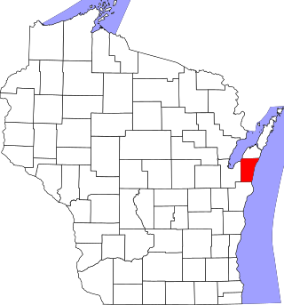
Location of Door County in Wisconsin
This is a list of the National Register of Historic Places listings in Door County, Wisconsin. It is intended to provide a comprehensive listing of entries in the National Register of Historic Places that are located in Door County, Wisconsin. The locations of National Register properties for which the latitude and longitude coordinates are included below may be seen in a map.[1]
There are 78 properties and districts listed on the National Register in the county. Another property was once listed but has been removed. Two listings have also been designated as National Historic Landmarks.
139-foot 2-masted wooden schooner-barge built in 1871 by Alvin A. Turner in Trenton, Michigan. Hauled lumber from Peshtigo to Chicago, then in 1898 started hauling stone. In 1921, while off-loading 7,000 tons of coal from a stranded steamer, she was caught by the wind and sank.[6][7]
Norwegian immigrant Aslag Anderson started a pier here in 1858, from which Ephraim shipped out poles and ships brought in cargo and passengers.[8] Remaining are the store started in 1858, Aslag's house built in 1864, the warehouse, an ice house, and other structures.[9][10]
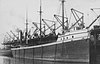
285-foot bulk carrier built in 1884 in Bay City, the largest wooden ship ever built at that time. She hauled salt, wheat, etc from Duluth to Buffalo to Cleveland. On Oct 10, 1896, heading for Milwaukee carrying 2,200 tons of coal, she caught fire off Baileys Harbor and the crew scuttled her in shallow water.[11][12]
A pair of lights built in 1869 to show ships a safe channel into Bailey's Harbor. The rear light was also a house for the lightkeeper. Served until 1969.[13]
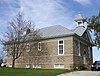
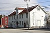
1937 Colonial revival building clad with local limestone, designed by Two Rivers architect Sylvester Schmitt, and funded by local-boy-become-Chicago-industrialist William McArdle and the WPA. Still serves the community.[14]
The Boaz was built by Amos Stoakes of Sheboygan in 1869 as an 83-foot 3-masted wooden schooner with a single centerboard. It spent its life carrying lumber around southern Lake Michigan. After damage in a squall at Green Bay in 1873, the ship was lengthened to 114 feet. A second centerboard was probably added then. In November 1900, heading to Racine with a load of elm lumber, the ship began leaking in a storm and was towed to North Bay, where it sank.[15]
Remains of three ships visible in shallow water from shore. All hauled limestone for the Sturgeon Bay Stone Company at the ends of their lives and were burned in 1931. They are the 212-foot steamerEmpire State built in 1862, the 134-foot centerboardschoonerOak Leaf, and the 168-foot schooner-barge Ida Corning.[18]
In 1869 a 65-foot brick tower was built, with a lightkeeper's house and third-order Fresnel lens. A steel skin was added to protect the deteriorating brick in 1902.[19]
139-foot schooner built by Hanson & Scove in Manitowoc in 1871 and named for a Swedish diva. In October 1884, hauling 575 tons of pig iron to Chicago, she was driven by a gale onto a reef and wrecked.[23]
Oldest remaining church building in Fish Creek, built in 1878 in Carpenter Gothic style with board and batten exterior as an Episcopal mission church.[24]
Wreck of a 170-foot wooden vessel next to remains of a crib-and-stone pier in Little Sturgeon Bay, lost under murky circumstances around 1898. It is believed to be a once-fast steamship reduced after burning to a barge for hauling limestone. A.k.a. Claflin Point.[25]
83-foot 2-masted wooden single-centerboard schooner built by Myron Williams of Marysville, Michigan around 1862. In 1864 it was modified for speed, expanded to a 111-foot 3-masted double-centerboard schooner. In 1875 it was damaged in a collision with the Rouse Simmons. In 1896, carrying a load of tamarack tan-bark to the Allen and Sons Tannery in Kenosha, she overturned in a squall. Salvage attempts got her into Bailey's Harbor where she sank just short of rescue.[32]
First church on the Door Peninsula, begun in 1857 by Moravian evangelist Andreas Iverson. It originally sat near the shore, but was moved up the hill in 1883.[33]
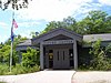
Community hall built in 1927 in Arts and Crafts style, clad in limestone from Eagle Bluff. Hosted village meetings, basketball, a library, fish boils, rummage sales, etc.[34]
132-foot two-masted schooner built in 1867 in Manitowoc by Henry Burger. Carried grain, coal and lumber from Chicago to Buffalo. On Sept 26, 1888, heading from Menominee toward Chicago in a gale, she tried to pass through Death's Door, but ran off course and grounded.[37]
301-foot wooden bulk carrier built in 1892 by James Davidson's shipyard in Bay City. On Sept 29, 1919, heading from Buffalo to Milwaukee hauling 3000 tons of coal, she caught fire and sank off Cana Island.[38]
130-foot wooden centerboardschooner built in 1855 by B.B. Jones in Buffalo. Hauled lumber, wheat and coal on the upper Great Lakes until November 1867, when a gale drove her aground near Plum Island.[43]
The Hanover was a 109-foot 2-masted schooner constructed in New York in 1853. It hauled bulk cargo (primarily grain) up and down the Great Lakes until 1863, when a gale drove it aground off the Strawberry Islands, where it was stripped and abandoned.[45][46]
One of the first hotels in Ephraim, opened around 1900 as the area transitioned from lumber and fishing to tourism. Started by Norwegian immigrant Martin Oleson and his family. Includes wooden hotel, cottages and outbuildings, with one started as early as 1864.[47][48]
Remains of three old piers started in 1848 for loading shingles and poles into schooners headed for Milwaukee and Chicago. Remains of three schooners lie nearby: the Perry Hannah was wrecked by the Alpena Blow of 1880, the Cecilia wrecked by a storm in 1885, and possibly the Annie Dahl, wrecked by a storm in 1898.[50] Additional documentation and boundary increase July 27, 2015 (#15000478)
131-foot wooden steambarge built in 1884 by the Milwaukee Shipyard Company. Hauled lumber, iron and stone. Caught fire in the Sturgeon Bay ship canal in 1898, burned and sank.[56][57]
In 1886, the Cambria was built as a bulk freighter and was an early user of steel hull plates and a triple-expansion steam engine. In 1910 it was remodeled into a passenger steamer, and in 1920 into a car carrier. In December 1924, hauling a load of automobiles from Chicago, some of her steel plates buckled in heavy seas, and she eventually went down in 205 feet of water.[58]
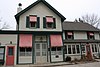
Elegant Italianate office built in 1875, with a large cornice atop a Boomtown front. Built by Adolph Larson, who manufactured ornamental woodwork, furniture and coffins. A.k.a. Challoner Morse McBride Law Office.[59]
Historic district with 28 contributing buildings, including the 1909 Romanesque Revival St. Joseph's church and various homes built from 1890 to 1920.[62]
120-foot schooner built in 1848 at Black River, Ohio. Hauled timber around the Great Lakes for 25 years until October of 1873, when she was driven by a fall storm onto the Sister Islands shoal in Green Bay and wrecked.[63]
Show farm built 1918 to 1925 by Green Bay millionaires Frank and Eldridge Murphy to show off their Holstein-Friesian cattle breeding project. Includes Dutch Colonial Revival homes and gambrel-roofed barns.[65]
Rural historic district settled by French-speaking Belgian farmers, consisting of 261 buildings built between 1871 and 1930,[66] including farmsteads, homes, the 1891 St. Mary of the Snows Catholic Church, the 1910 Fairland School, and the 1916 William Struck store.[67]
The first home in Fish Creek fancier than a log cabin, built 1868 or 1875. Noble was a blacksmith, farmer, postmaster, and town chairman. Today the house is a museum, and the oldest building in town on its original location.[68][69]
112-foot wood-hulled two-masted schooner built in 1854 by Alanson Gilmore at Black River, Ohio. Hauled grain, lumber and other bulk cargo around the Great Lakes. In November 1901, while hauling lumber from East Jordan, Michigan to Chicago, a storm forced her to shelter in Baileys Harbor, where the storm drove her onto the beach.[71][72]
Norwegian immigrant Peterson was storekeeper, town chairman, justice of the peace, and founder of the congregation that would become Bethany Lutheran. The 1874 house was used as a parsonage after Peterson returned to Norway in 1883.[73]
Brick lightkeeper's house built in 1858 with a 41-foot tower on top, on an island at the east end of Death's Door. Regular heavy fogs in the area prompted addition of Daboll's trumpets foghorns in 1864, with later upgrades.[74]
Wrecks of three wooden ships commingled on the reef SW of the island: the 115-foot scow-schoonerForest built in 1857 and wrecked by a storm in October of 1891, the 147-foot schooner A. P. Nichols built in 1861 and wrecked by a storm in October of 1892, and the 138-foot canaller-schooner J. E. Gilmore, built in 1867 and wrecked by another storm only 11 days after the Nichols.[75]
The first light to guide ships through Death's Door was built here in 1846, but moved to Pilot Island around 1858. In 1896 a set of range lights was built, with foghorn, keeper's house and a life-saving station.[76]
One of a pair of range lights built around 1897 so ships could line up on a safe course through the dangerous Death's Door passage. The front light was replaced in 1964.[76]
Prehistoric lakeshore camp along the Porte des Morts strait; occupied by Woodland and Mississippian peoples, the site has produced varied tools and styles of pottery.[77]
75-foot wooden observation tower built in 1931[78] by the Wisconsin State Conservation Corps - the first purpose-built recreational tower in a Wisconsin state park.[79]
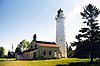
Keeper's dwelling and light tower, built in 1858 of native limestone on a bluff 137 feet above water level at the tip of the Door Peninsula. Served until 1988. An earlier lighthouse on the site, built 1836-7, was the first lighthouse on Lake Michigan and first in Wisconsin.[80]
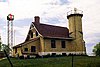
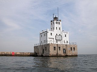
Red brick lightkeeper's dwelling with light tower built in 1883 on a 30-foot bluff at the west entrance to the Sturgeon Bay Ship Canal. A 600-pound fog bell was added in 1892.[82]
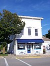
Built in 1881, this is the only remaining residence in Sturgeon Bay that is clad in Frear stone, an early concrete cladding system licensed from Chicago but manufactured locally by Giles Kirtland. The style is Italianate, with window hoods of Frear stone and decorative cross-bracing in the gable ends.[83][84]
151-ton 2-masted scow schooner built in 1875 in Manitowoc. Hauled lumber on Lake Michigan until November 1896, when she was pushed aground by a storm while loading in Whitefish Bay. Still quite intact, with wire rigging, deadeyes, bilge pump and centerboard present.[90][91]
Wooden scowschooner built by Jerry Dupree in Detroit in 1856. Mostly carried lumber from northern Michigan to Wisconsin and Illinois. Driven ashore by a gale in September 1869, while heading for Chicago with a load of lumber.[92]
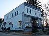
Mixed business and residential district including the 1872 John Masse Hardware-Tin Shop, the Queen Anne Wegener Business Block built in the 1880s and 1890s, the 1906 Neoclassical Merchant's Exchange Bank, and the 1935 Art Moderne George Draeb Jewelry Store.[94]
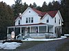
Queen Anne-style house started in 1902 by boat-builder Freeman Thorpe. After he drowned in Green Bay in 1903, his wife Jesse finished the house and rented out rooms. Six tourist cottages were added in the 1940s.[97] Now a B&B.[98]
Largely consists of buildings from the resort founded by German immigrant Dr. Herman Welcker in 1907 with a regimen influenced by European health spas of the time, catering initially to Germans from Milwaukee. District includes former cottages of the resort, the current White Gull Inn, and the current Whistling Swan, which was the Lumberman's Hotel in Marinette before Welcker had it hauled across Green Bay on the ice to become his "Casino."[101][102][103]
Barn and house built around 1896 by Zachow. Walls of the barn and part of the house are unusual stovewood construction. It was later used as the Alchemy Fields art gallery.[105][106][107]
Point Iroquois Light is a lighthouse on a Chippewa County bluff in the U.S. state of Michigan. Point Iroquois and its light mark the division line between Whitefish Bay and the western end of the St. Marys River, the connection between Lake Superior and other Great Lakes.
The La Pointe Light is a lighthouse located on Long Island, one of the Apostle Islands, in Lake Superior in Ashland County, Wisconsin, near the city of Bayfield.
The Devils Island Lighthouse is a lighthouse located on Devils Island, one of the Apostle Islands, in Lake Superior in Ashland County, Wisconsin, near the city of Bayfield. Among the Apostle Islands lighthouses—a testament to its remoteness—it was the last built, and the last automated and unmanned.
The Raspberry Island Lighthouse is a lighthouse located on the southern part of Raspberry Island, marking the west channel of the Apostle Islands in Lake Superior in Bayfield County, Wisconsin, near the city of Bayfield. It was erected in 1862, marking the western channel.
Kenosha Light Station is a lighthouse and keeper's house on Simmons Island north of the channel into Kenosha's harbor in Kenosha County, Wisconsin.
The Plum Island Range Lights are a pair of range lights located on Plum Island in Door County, Wisconsin. Plum Island was transferred to the United States Fish and Wildlife Service in 2007 and became part of the Green Bay National Wildlife Refuge. Plum Island is seasonally open to the public for day-time use.
Wind Point Lighthouse is a lighthouse located at the north end of Racine Harbor in the U.S. state of Wisconsin. It is in the village of Wind Point, Wisconsin, on Lighthouse Road, next to the Shoop Park golf course. The lighthouse stands 108 feet (33 m) tall. One of the oldest and tallest active lighthouses on the Great Lakes, it was listed on the National Register of Historic Places in 1984.
The Milwaukee Breakwater lighthouse was built in 1926 in the harbor of Milwaukee in Milwaukee County, Wisconsin to mark the entrance to the harbor. One of the last fully enclosed breakwater lighthouses in the Great Lakes, the structure was placed on the National Register of Historic Places in 2011.
This is a list of the National Register of Historic Places listings in Brown County, Wisconsin. It is intended to provide a comprehensive listing of entries in the National Register of Historic Places that are located in Brown County, Wisconsin. The locations of National Register properties for which the latitude and longitude coordinates are included below may be seen in a map.
This is a list of the National Register of Historic Places listings in Ozaukee County, Wisconsin. It is intended to provide a comprehensive listing of entries in the National Register of Historic Places that are located in Ozaukee County, Wisconsin. The locations of National Register properties for which the latitude and longitude coordinates are included below may be seen in a map.
This is a list of the National Register of Historic Places listings in Sheboygan County, Wisconsin. It is intended to provide a comprehensive listing of entries in the National Register of Historic Places that are located in Sheboygan County, Wisconsin. The locations of National Register properties for which the latitude and longitude coordinates are included below may be seen in a map.
This is a list of the National Register of Historic Places listings in Walworth County, Wisconsin. It is intended to provide a comprehensive listing of entries in the National Register of Historic Places that are located in Walworth County, Wisconsin. The locations of National Register properties for which the latitude and longitude coordinates are included below may be seen in a map.
This is a list of the National Register of Historic Places listings in Ashland County, Wisconsin. It is intended to provide a comprehensive listing of entries in the National Register of Historic Places that are located in Ashland County, Wisconsin. The locations of National Register properties for which the latitude and longitude coordinates are included below may be seen in a map.
This is a list of the National Register of Historic Places listings in Marinette County, Wisconsin. It is intended to provide a comprehensive listing of entries in the National Register of Historic Places that are located in Marinette County, Wisconsin. The locations of National Register properties for which the latitude and longitude coordinates are included below may be seen in a map.
This is a list of the National Register of Historic Places listings in Bayfield County, Wisconsin. It is intended to provide a comprehensive listing of entries in the National Register of Historic Places that are located in Bayfield County, Wisconsin. The locations of National Register properties for which the latitude and longitude coordinates are included below may be seen in a map.
This is a list of the National Register of Historic Places listings in Manitowoc County, Wisconsin. It is intended to provide a comprehensive listing of entries in the National Register of Historic Places that are located in Manitowoc County, Wisconsin. The locations of National Register properties for which the latitude and longitude coordinates are included below may be seen in a map.
This is a list of the National Register of Historic Places listings in Douglas County, Wisconsin. It is intended to provide a comprehensive listing of entries in the National Register of Historic Places that are located in Douglas County, Wisconsin. The locations of National Register properties for which the latitude and longitude coordinates are included below may be seen in a map.
This is a list of the National Register of Historic Places listings in Kewaunee County, Wisconsin. It is intended to provide a comprehensive listing of entries in the National Register of Historic Places that are located in Kewaunee County, Wisconsin. The locations of National Register properties for which the latitude and longitude coordinates are included below may be seen in a map.
This is a list of the National Register of Historic Places listings in Chippewa County, Wisconsin. It is intended to provide a comprehensive listing of entries in the National Register of Historic Places that are located in Chippewa County, Wisconsin. The locations of National Register properties for which the latitude and longitude coordinates are included below may be seen in a map.
References
↑ The latitude and longitude information provided is primarily from the National Register Information System, and has been found to be fairly accurate for about 99% of listings. For 1%, the location info may be way off. We seek to correct the coordinate information wherever it is found to be erroneous. Please leave a note in the Discussion page for this article if you believe any specific location is incorrect.
1 2 Numbers represent an alphabetical ordering by significant words. Various colorings, defined here, differentiate National Historic Landmarks and historic districts from other NRHP buildings, structures, sites or objects.
↑ The eight-digit number below each date is the number assigned to each location in the National Register Information System database, which can be viewed by clicking the number.
↑ Thomsen, Tamara; Keith Meverden. "Australasia Shipwreck (Wooden Bulk Carrier)"(PDF). National Register of Historic Places Registration Form. National Park Service - U.S. Department of the Interior (Archive.org). Archived from the original(PDF) on 11 June 2015. Retrieved 2015-06-11.
↑ Ritzenthaler, Robert E. (December 1950). "Wisconsin Petroglyphs and Pictographs". Wisconsin Archeologist. 31 (4): 97.
↑ "J.B. Bouche House". Architecture and History Inventory. Wisconsin Historical Society. Retrieved 2013-11-17.
↑ "Bullhead Point Site". Wisconsin's Great Lakes Shipwrecks. Wisconsin Historical Society / UW - Sea Grant. Archived from the original on 2022-04-07. Retrieved 2022-04-07.
↑ "Christina Nilsson". Wisconsin's Great Lakes Shipwrecks. Wisconsin Historical Society & University of Wisconsin Sea Grant. Archived from the original on 2013-06-02. Retrieved 2013-11-23.
↑ "Church of the Atonement". Architecture and History Inventory. Wisconsin Historical Society. Retrieved 2013-11-23.
↑ "Ephraim Village Hall". Architecture and History Inventory. Wisconsin Historical Society. Retrieved 2013-11-29.
↑ "Joachine J. Falque House". Architecture and History Inventory. Wisconsin Historical Society. Retrieved 2013-11-29.
1 2 3 4 Location given in Kohl, Cris (2001). The Great Lakes Diving Guide. West Chicago, Ill.: Seawolf Communications, Inc. NRIS lists site as "address restricted".
↑ "Fleetwing". Wisconsin's Great Lakes Shipwrecks. University of Wisconsin Sea Grant and Wisconsin Historical Society. Archived from the original on 2013-06-02. Retrieved 2013-11-29.
↑ "Frank O'Connor". Wisconsin's Great Lakes Shipwrecks. University of Wisconsin Sea Grant and Wisconsin Historical Society. Retrieved 2013-11-29.
↑ "Shipwrecks". Wisconsin's Schooner Coast. Wisconsin's Schooner Coast (on Archive.org). Archived from the original on 7 July 2014. Retrieved 2014-07-07.
↑ "Joys (1884)". Wisconsin Historical Society Shipwreck Database. Wisconsin Historical Society. Retrieved January 29, 2018.
↑ "Meridian". Wisconsin's Great Lakes Shipwrecks. Wisconsin Historical Society and UW Sea Grant Institute. Archived from the original on 2013-06-02. Retrieved 2013-12-19.
↑ "Joseph Monfils Farmstead". Architecture and History Inventory. Wisconsin Historical Society. Retrieved 2013-12-22.
↑ "Murphy Farms Number 1". National Register or State Register. Wisconsin Historical Society. Retrieved 2013-12-22.
↑ "Peterson, Peter, House". Architecture and History Inventory. Wisconsin Historical Society. Retrieved 2013-12-27.
↑ Pepper, Terry. "Pilot Island". Seeing the Light. Terry Pepper. Retrieved 2013-12-31.
↑ "Pilot Island". Wisconsin's Great Lakes Shipwrecks. Wisconsin Historical Society and UW-Sea Grant. Archived from the original on 2013-06-02. Retrieved 2013-12-31.
1 2 Cartwright, Carol Lohry (1984-12-17). "Historic Chester H. Thordarson Estate"(PDF). National Register of Historic Places - Inventory Nomination Form. U.S. Department of the Interior - National Park Service. Archived from the original on 2012-10-15. Retrieved 2014-01-10.{{cite web}}: CS1 maint: bot: original URL status unknown (link)
This page is based on this Wikipedia article Text is available under the CC BY-SA 4.0 license; additional terms may apply. Images, videos and audio are available under their respective licenses.