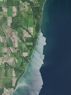
Clay Banks, Wisconsin

Last updated

Clay Banks, Wisconsin
Clay Banks, Door County, Wisconsin 2020.png
Part of eastern and central Clay Banks
WIMap-doton-Clay Banks.png
Location of Clay Banks, Wisconsin
Coordinates: 44°43′18″N87°21′49″W / 44.72167°N 87.36361°W / 44.72167; -87.36361
Country Flag of the United States.svg  United States
State Flag of Wisconsin.svg  Wisconsin
County Door
Area
  Total47.1 sq mi (122.0 km2)
  Land14.9 sq mi (38.6 km2)
  Water32.2 sq mi (83.4 km2)
Elevation
[1]
577 ft (176 m)
Population
 (2000)
  Total410
  Density27.5/sq mi (10.6/km2)
Time zone UTC-6 (Central (CST))
  Summer (DST) UTC-5 (CDT)
Area code 920
FIPS code 55-15025 [2]
GNIS feature ID1582965 [1]
Website https://www.townofclaybanks.org/

Clay Banks is a town in Door County, Wisconsin, United States. The population was 410 at the 2000 census. The unincorporated communities of Salona, and Vignes are located in the town. [3]

Contents

Geography

According to the United States Census Bureau, the town has a total area of 47.1 square miles (122.0 km2), of which, 14.9 square miles (38.6 km2) of it is land and 32.2 square miles (83.4 km2) of it (68.38%) is water.

Demographics

As of the census [2] of 2000, there were 410 people, 162 households, and 121 families residing in the town. The population density was 27.5 people per square mile (10.6/km2). There were 240 housing units at an average density of 16.1 per square mile (6.2/km2). The racial makeup of the town was 97.80% White, 1.22% Native American, 0.24% Asian, and 0.73% from two or more races.

There were 162 households, out of which 30.9% had children under the age of 18 living with them, 67.9% were married couples living together, 3.1% had a female householder with no husband present, and 25.3% were non-families. 19.1% of all households were made up of individuals, and 11.1% had someone living alone who was 65 years of age or older. The average household size was 2.53 and the average family size was 2.91.

In the town, the population was spread out, with 24.9% under the age of 18, 3.2% from 18 to 24, 25.1% from 25 to 44, 26.6% from 45 to 64, and 20.2% who were 65 years of age or older. The median age was 42 years. For every 100 females, there were 106.0 males. For every 100 females age 18 and over, there were 97.4 males.

The median income for a household in the town was $42,708, and the median income for a family was $46,458. Males had a median income of $31,250 versus $21,964 for females. The per capita income for the town was $19,027. About 9.0% of families and 8.2% of the population were below the poverty line, including 13.0% of those under age 18 and 5.3% of those age 65 or over.

Climate

Robert de La Salle Park
Climate chart (explanation)
J
F
M
A
M
J
J
A
S
O
N
D
 
 
57
 
 
−5
−6
 
 
54
 
 
−4
−13
 
 
60
 
 
1
−2
 
 
129
 
 
6
0
 
 
93
 
 
9
2
 
 
85
 
 
13
9
 
 
97
 
 
17
12
 
 
78
 
 
18
13
 
 
87
 
 
15
12
 
 
129
 
 
12
7
 
 
85
 
 
4
3
 
 
65
 
 
4
−1
Average max. and min. temperatures in °C
Precipitation totals in mm
Source: [4]
Imperial conversion
JFMAMJJASOND
 
 
2.2
 
 
23
21
 
 
2.1
 
 
25
9
 
 
2.4
 
 
34
28
 
 
5.1
 
 
43
32
 
 
3.7
 
 
48
36
 
 
3.3
 
 
55
48
 
 
3.8
 
 
63
54
 
 
3.1
 
 
64
55
 
 
3.4
 
 
59
54
 
 
5.1
 
 
54
45
 
 
3.3
 
 
39
37
 
 
2.6
 
 
39
30
Average max. and min. temperatures in °F
Precipitation totals in inches

Notable people

Related Research Articles

<span class="mw-page-title-main">Clay, Alabama</span> City in Alabama, United States

Clay is a city in northeastern Jefferson County, Alabama, United States. It is part of the Birmingham–Hoover–Cullman Combined Statistical Area in the north-central part of the state. Local government is run by a mayor and city council.

<span class="mw-page-title-main">Carbon, Indiana</span> Town in Indiana, United States

Carbon is a town in Van Buren Township, Clay County, Indiana, United States. The population was 397 at the 2010 census. It is part of the Terre Haute Metropolitan Statistical Area.

<span class="mw-page-title-main">Center Point, Indiana</span> Town in Indiana, United States

Center Point is a town in Sugar Ridge Township, Clay County, Indiana, United States. The population was 242 at the 2010 census. It is part of the Terre Haute Metropolitan Statistical Area.

<span class="mw-page-title-main">Clay City, Indiana</span> Town in Indiana, United States

Clay City is a town in Harrison Township, Clay County, Indiana, United States. The population was 861 at the 2010 census. It is part of the Terre Haute Metropolitan Statistical Area.

<span class="mw-page-title-main">Bethany, Indiana</span> Town in Indiana, United States

Bethany is a town in Clay Township, Morgan County, in the U.S. state of Indiana. The population was 95 at the 2020 census.

<span class="mw-page-title-main">Delta, Iowa</span> City in Iowa, United States

Delta is a city in Keokuk County, Iowa, United States. The population was 264 at the 2020 census.

Burlington is a town in Penobscot County, Maine, United States. It is part of the Bangor Metropolitan Statistical Area. The population was 373 at the 2020 census.

Winn is a town in Penobscot County, Maine, United States, on the east bank of the Penobscot River. The town was named for John M. Winn, an early landholder. The population was 399 at the 2020 census.

<span class="mw-page-title-main">Brooks, Maine</span> Town in the state of Maine, United States

Brooks is a town in Waldo County, Maine, United States. The population was 1,010 at the 2020 census.

Louisville Township is a township in Scott County, Minnesota, United States. The population was 1,359 at the 2000 census.

<span class="mw-page-title-main">Randolph, Missouri</span> City in Missouri, United States

Randolph is a city in Clay County, Missouri, United States. The population was 57 at the 2020 census. It is completely surrounded by Kansas City and is a part of the Kansas City metropolitan area.

<span class="mw-page-title-main">Boys Town, Nebraska</span> Village in Douglas County, Nebraska, United States

Boys Town is a village in Douglas County, Nebraska, United States. The population was 410 at the 2020 census. Boys Town is an enclave and a suburb of Omaha.

<span class="mw-page-title-main">Bassett, Nebraska</span> City in and county seat of Rock County, Nebraska, United States

Bassett is a city in Rock County, Nebraska, United States. The population was 619 at the 2010 census. It is the county seat of Rock County.

<span class="mw-page-title-main">Wasco, Oregon</span> City in Oregon, United States

Wasco is a city in Sherman County, Oregon, United States. The population was 410 at the 2010 census.

<span class="mw-page-title-main">Clay Township, Lancaster County, Pennsylvania</span> Township in Pennsylvania, United States

Clay Township is a township in north central Lancaster County, Pennsylvania, United States. The population was 6,887 at the 2020 census.

<span class="mw-page-title-main">Bellevue, Wisconsin</span> Village in Wisconsin, United States

Bellevue is a village in Brown County, Wisconsin. It was a town until incorporating as a village on February 14, 2003. The population was 14,570 at the time of the 2010 census. Bellevue is part of the Green Bay metropolitan area. Bellevue sits around 4.34 miles (6.99 km) east from central Green Bay.

<span class="mw-page-title-main">Gibraltar, Wisconsin</span> Town in Wisconsin, United States

Gibraltar is a town in Door County, Wisconsin, United States. The population was 1,228 at the 2020 census. The unincorporated communities of Fish Creek and Juddville are located in the town.

<span class="mw-page-title-main">Forest, Fond du Lac County, Wisconsin</span> Town in Wisconsin, United States

Forest is a town in Fond du Lac County, Wisconsin, United States. The population was 1,108 at the 2000 census. The unincorporated communities of Banner, Dotyville, and Graham Corners are located in the town.

<span class="mw-page-title-main">Freedom, Sauk County, Wisconsin</span> Town in Wisconsin, United States

The Town of Freedom is a located in Sauk County, Wisconsin, United States. The population was 416 at the 2000 census. The unincorporated community of La Rue is located within the town. The town was named from the American ideal of freedom.

<span class="mw-page-title-main">Madge, Wisconsin</span> Town in Wisconsin, United States

Madge is a town in Washburn County, Wisconsin, United States. The population was 454 at the 2000 census.

References

  1. 1 2 "US Board on Geographic Names". United States Geological Survey. October 25, 2007. Retrieved January 31, 2008.
  2. 1 2 "U.S. Census website". United States Census Bureau . Retrieved January 31, 2008.
  3. Map of the Town of Clay Banks, Door County Land Use Services Department, June 5, 2018 (Archived April 9, 2019)
  4. "NASA EarthData Search". NASA. Retrieved January 30, 2016.