Forestville, Wisconsin

Last updated • 3 min readFrom Wikipedia, The Free Encyclopedia

Forestville, Wisconsin
ForestvilleWisconsinNorthWIS42.jpg
Looking north at downtown Forestville
Door County Wisconsin Incorporated and Unincorporated areas Forestville Highlighted.svg
Location of Forestville in Door County, Wisconsin.
Coordinates: 44°41′22″N87°28′50″W / 44.68944°N 87.48056°W / 44.68944; -87.48056
Country Flag of the United States.svg  United States
State Flag of Wisconsin.svg  Wisconsin
County Door
Area
[1]
  Total
0.52 sq mi (1.35 km2)
  Land0.52 sq mi (1.35 km2)
  Water0.00 sq mi (0.00 km2)
Elevation
[2]
719 ft (219 m)
Population
 (2020) [3]
  Total
482
  Density930/sq mi (360/km2)
Time zone UTC-6 (Central (CST))
  Summer (DST) UTC-5 (CDT)
ZIP code
54213
Area code 920
FIPS code 55-26625
Website Village of Forestville

Forestville is a village in Door County, Wisconsin, United States, along the Ahnapee River. [4] The population was 482 at the 2020 census. The village is located within the Town of Forestville. The village uses the 54213 ZIP code. [5] The Ahnapee State Trail passes through the village on the southwest. [6]

Contents

History

Major Joseph McCormick was the first white man to settle in Forestville. He was of Scotch-Irish descent. He won his military title in the Mexican War. He discovered what he thought was a layer of marble. McCormick is responsible for bringing a great many settlers to Forestville. He spoke persuasively of the marble quarries, the water power, and the timber resources. [7]

Geography

Post office Forestville Wisconsin post office.jpg
Post office
Southern Door fire department station in Forestville Southern Door fire department at Forestville Wisconsin.jpg
Southern Door fire department station in Forestville

Forestville is located at 44°41′22″N87°28′50″W / 44.68944°N 87.48056°W / 44.68944; -87.48056 (44.689462, -87.480758). [8]

According to the United States Census Bureau, the village has a total area of 0.52 square miles (1.35 km2), all of it land. [9]

Demographics

Historical population
CensusPop.Note
1970 349
1980 45530.4%
1990 4703.3%
2000 429−8.7%
2010 4300.2%
2020 48212.1%
U.S. Decennial Census [10]
Looking south at the sign for Forestville ForestvilleWisconsinSignWIS42.jpg
Looking south at the sign for Forestville

2010 census

As of the census [11] of 2010, there were 430 people, 183 households, and 129 families living in the village. The population density was 826.9 inhabitants per square mile (319.3/km2). There were 206 housing units at an average density of 396.2 per square mile (153.0/km2). The racial makeup of the village was 98.1% White, 0.7% Native American, and 1.2% from two or more races. Hispanic or Latino of any race were 1.9% of the population.

There were 183 households, of which 33.9% had children under the age of 18 living with them, 56.8% were married couples living together, 9.3% had a female householder with no husband present, 4.4% had a male householder with no wife present, and 29.5% were non-families. 24.0% of all households were made up of individuals, and 9.8% had someone living alone who was 65 years of age or older. The average household size was 2.35 and the average family size was 2.78.

The median age in the village was 43.6 years. 20.7% of residents were under the age of 18; 6.8% were between the ages of 18 and 24; 25.4% were from 25 to 44; 29.1% were from 45 to 64; and 18.1% were 65 years of age or older. The gender makeup of the village was 49.3% male and 50.7% female.

2000 census

As of the census [12] of 2000, there were 429 people, 181 households, and 120 families living in the village. The population density was 823.7 people per square mile (318.5/km2). There were 202 housing units at an average density of 387.8 per square mile (150.0/km2). The racial makeup of the village was 99.07% White, 0.70% Black or African American, and 0.23% from two or more races. 0.00% of the population were Hispanic or Latino of any race.

There were 181 households, out of which 29.3% had children under the age of 18 living with them, 55.8% were married couples living together, 7.7% had a female householder with no husband present, and 33.7% were non-families. 30.9% of all households were made up of individuals, and 17.1% had someone living alone who was 65 years of age or older. The average household size was 2.37 and the average family size was 2.92.

In the village, the population was spread out, with 22.6% under the age of 18, 7.0% from 18 to 24, 28.7% from 25 to 44, 24.5% from 45 to 64, and 17.2% who were 65 years of age or older. The median age was 41 years. For every 100 females, there were 96.8 males. For every 100 females age 18 and over, there were 94.2 males.

The median income for a household in the village was $39,167, and the median income for a family was $50,313. Males had a median income of $31,146 versus $19,688 for females. The per capita income for the village was $16,521. About 1.7% of families and 7.4% of the population were below the poverty line, including 1.0% of those under age 18 and 23.0% of those age 65 or over.

Climate

Forestville
Climate chart (explanation)
J
F
M
A
M
J
J
A
S
O
N
D
 
 
57
 
 
−5
−10
 
 
54
 
 
−5
−11
 
 
60
 
 
1
−6
 
 
129
 
 
9
0
 
 
93
 
 
16
4
 
 
85
 
 
20
10
 
 
97
 
 
24
14
 
 
78
 
 
22
14
 
 
87
 
 
20
10
 
 
129
 
 
12
5
 
 
85
 
 
3
−2
 
 
65
 
 
−3
−7
Average max. and min. temperatures in °C
Precipitation totals in mm
Source: [13]
Imperial conversion
JFMAMJJASOND
 
 
2.2
 
 
23
14
 
 
2.1
 
 
23
12
 
 
2.4
 
 
34
21
 
 
5.1
 
 
48
32
 
 
3.7
 
 
61
39
 
 
3.3
 
 
68
50
 
 
3.8
 
 
75
57
 
 
3.1
 
 
72
57
 
 
3.4
 
 
68
50
 
 
5.1
 
 
54
41
 
 
3.3
 
 
37
28
 
 
2.6
 
 
27
19
Average max. and min. temperatures in °F
Precipitation totals in inches

Related Research Articles

<span class="mw-page-title-main">Coe Township, Michigan</span> Civil township in Michigan, United States

Coe Township is a civil township of Isabella County in the U.S. state of Michigan. The population was 3,032 at the 2020 census.

<span class="mw-page-title-main">Forestville, Michigan</span> Village in Michigan, United States

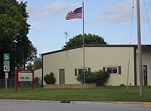
Forestville is a village in Sanilac County in the U.S. state of Michigan. The population was 104 at the 2020 census, making it the least-populous village in Michigan. It does not have a true harbor onto Lake Huron, but the village does have a boat launch site. Forestville receives city water from nearby Harbor Beach. The village is within Delaware Township.

<span class="mw-page-title-main">Forestville Township, Fillmore County, Minnesota</span> Township in Minnesota, United States

Forestville Township is a township in Fillmore County, Minnesota, United States. The population was 356 as of the 2010 census. It contains historic Forestville, which is now a living history museum within Forestville/Mystery Cave State Park.

<span class="mw-page-title-main">Sycamore Hills, Missouri</span> Village in Missouri, United States

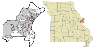
Sycamore Hills is a village in St. Louis County, Missouri, United States. The population is 560 at the 2020 census.

<span class="mw-page-title-main">Sheridan, New York</span> Town in New York, United States

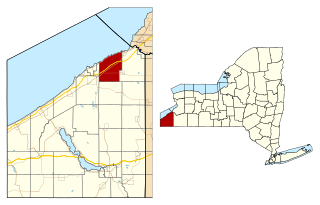
Sheridan is a town in Chautauqua County, New York, United States. The population was 2,563 at the 2020 census. The town is on the county's northern border, east of Dunkirk.

<span class="mw-page-title-main">Forestville, Ohio</span> Census-designated place in Ohio, United States

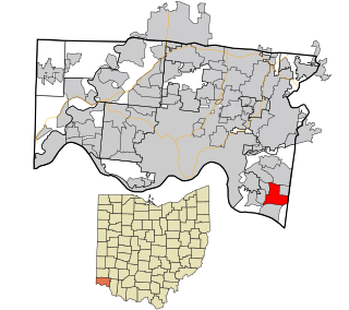
Forestville is a census-designated place (CDP) in Anderson Township, Hamilton County, Ohio, United States. The population was 10,615 at the 2020 census.

<span class="mw-page-title-main">Ridgebury Township, Pennsylvania</span> Township in Pennsylvania, United States

Ridgebury Township is a township in Bradford County, Pennsylvania, United States. It is part of Northeastern Pennsylvania. The population was 1,978 at the 2010 census.

Forestville is a census-designated place (CDP) in Schuylkill County, Pennsylvania, United States. The population was 431 at the 2000 census.

<span class="mw-page-title-main">Rouseville, Pennsylvania</span> Borough in Pennsylvania, United States

Rouseville is a borough in Venango County, Pennsylvania, United States. The population was 456 at the 2020 census.

<span class="mw-page-title-main">Windsor Heights, West Virginia</span> Village in West Virginia, United States

Windsor Heights is a village in Brooke County, West Virginia, United States. It is part of the Wheeling, West Virginia Metropolitan Statistical Area. The population was 423 at the 2010 census. Grace Davis was the mayor as of June 2017.

<span class="mw-page-title-main">Ahnapee, Wisconsin</span> Town in Wisconsin, United States

Ahnapee is a town in Kewaunee County, Wisconsin, United States, on the Ahnapee River. The population was 940 as of the 2010 census. The Ahnapee State Trail passes through the town of Ahnapee.

<span class="mw-page-title-main">Algoma, Wisconsin</span> City in Wisconsin, United States

Algoma is a city in Kewaunee County, Wisconsin, United States. The population was 3,243 at the 2020 census. Algoma is part of the Green Bay metropolitan area.

<span class="mw-page-title-main">Bay City, Wisconsin</span> Village in Wisconsin, United States

Bay City is a village on the Mississippi River in Pierce County, Wisconsin, United States. The population was 500 at the 2010 census.

<span class="mw-page-title-main">Meteor, Wisconsin</span> Town in Wisconsin, United States

Meteor is a town in Sawyer County, Wisconsin, United States. The population was 170 at the 2000 census.

<span class="mw-page-title-main">Wilson, St. Croix County, Wisconsin</span> Village in Wisconsin, United States

Wilson is a village in St. Croix County, Wisconsin, United States. The population was 184 at the 2010 census.

<span class="mw-page-title-main">Verona, Ohio</span> Village in Ohio, United States

Verona is a village in Montgomery and Preble counties in the U.S. state of Ohio. The population was 403 at the 2020 census. It is part of the Dayton Metropolitan Statistical Area.

<span class="mw-page-title-main">Unity, Wisconsin</span> Village in Wisconsin, United States

Unity is a village in Clark and Marathon counties in the U.S. state of Wisconsin. It is part of the Wausau, Wisconsin Metropolitan Statistical Area. The population was 343 at the 2010 census. Of this, 204 were in Marathon County, and 139 were in Clark County. The village is located in northeastern town of Unity in Clark County and northwestern town of Brighton in Marathon County.

<span class="mw-page-title-main">Forestville (town), Wisconsin</span> Town in Wisconsin, United States

Forestville is a town in Door County, Wisconsin, United States. The population was 1,096 at the 2010 census. The Village of Forestville is located within the town, but the two are politically independent.

<span class="mw-page-title-main">Woodman, Wisconsin</span> Village in Wisconsin, United States

Woodman is a village in Grant County in the U.S. state of Wisconsin. The population was 118 at the 2020 census. The village is located within the Town of Woodman.

<span class="mw-page-title-main">Casco, Wisconsin</span> Village in Wisconsin, United States

Casco is a village in Kewaunee County, Wisconsin, United States. The population was 583 at the 2010 census. It is part of the Green Bay Metropolitan Statistical Area. The village is located within the Town of Casco. Casco is named after Casco Bay on the coast of Maine, the previous home of Edward Decker, an early logger in Kewaunee County.

References

  1. "2019 U.S. Gazetteer Files". United States Census Bureau. Retrieved August 7, 2020.
  2. "US Board on Geographic Names". United States Geological Survey. October 25, 2007. Retrieved January 31, 2008.
  3. "Census Bureau profile: Forestville village, Wisconsin". United States Census Bureau. May 2023. Retrieved November 26, 2024.
  4. Map of the Village of Forestville, Door County Land Use Services Department, August 16, 2017 (Archived April 9, 2019)
  5. "Forestville ZIP code". United States Post Office . Retrieved June 30, 2014.
  6. Interactive map showing how the trail goes through Forestville. While the map is for the Ice Age Trail, Forestville is one of the areas where the trails coincide.
  7. River, Railroad Played Role in "Village of Forests" by Rita Schlise, Door County Advocate, March 22, 1962, section 3k
  8. "US Gazetteer files: 2010, 2000, and 1990". United States Census Bureau. February 12, 2011. Retrieved April 23, 2011.
  9. "US Gazetteer files 2010". United States Census Bureau. Archived from the original on July 2, 2012. Retrieved November 18, 2012.
  10. "Census of Population and Housing". Census.gov. Retrieved June 4, 2015.
  11. "U.S. Census website". United States Census Bureau . Retrieved November 18, 2012.
  12. "U.S. Census website". United States Census Bureau . Retrieved January 31, 2008.
  13. "NASA EarthData Search". NASA. Retrieved January 30, 2016.