National Register of Historic Places listings in Kewaunee County, Wisconsin

Last updated

Location of Kewaunee County in Wisconsin Map of Wisconsin highlighting Kewaunee County.svg
Location of Kewaunee County in Wisconsin

This is a list of the National Register of Historic Places listings in Kewaunee County, Wisconsin. It is intended to provide a comprehensive listing of entries in the National Register of Historic Places that are located in Kewaunee County, Wisconsin. The locations of National Register properties for which the latitude and longitude coordinates are included below may be seen in a map. [1]

Contents

There are 13 properties and districts listed on the National Register in the county. Another property was once listed but has been removed.


    This National Park Service list is complete through NPS recent listings posted November 10, 2023. [2]

Map all coordinates using: OpenStreetMap

Current listings

[3] Name on the Register [4] ImageDate listed [5] Location City or townDescription
1 AMERICA Shipwreck (Canaller)
AMERICA Shipwreck (Canaller) America shipwreck.jpg
AMERICA Shipwreck (Canaller)
July 3, 2013
(#13000467)
Four miles offshore in Lake Michigan
44°21′01″N87°24′56″W / 44.350232°N 87.415667°W / 44.350232; -87.415667 (AMERICA Shipwreck (Canaller))
Lake Michigan 137-foot three-masted canaller (schooner built specifically to squeeze through the Welland Canal), built in 1873. She hauled grain and lumber east as far as New York state, and brought back coal. Sank in 1880 after hitting a scow full of stones. [6]
2 Ahnapee Brewery
Ahnapee Brewery AhnapeeBreweryVonStiehlWineryAlgomaWisconsin.jpg
Ahnapee Brewery
June 17, 1994
(#94000597)
115 Navarino St.
44°36′35″N87°26′07″W / 44.609722°N 87.435278°W / 44.609722; -87.435278 (Ahnapee Brewery)
Algoma Built in 1868, the building served as a brewery until 1890, then a warehouse, fly net factory, washing machine factory, feed storage, and now the Von Stiehl Winery. [7]
3 DANIEL LYONS (Shipwreck) October 3, 2007
(#07001048)
E of Stoney Cr. outlet, 4 mi (6.4 km). offshore
44°40′21″N87°17′43″W / 44.6725°N 87.295278°W / 44.6725; -87.295278 (DANIEL LYONS (Shipwreck))
Lake Michigan Three-masted schooner built in 1873. Sank in 1878 after being hit by another schooner, on a run from Chicago to New York. [8]
4 Art Dettman Fishing Shanty
Art Dettman Fishing Shanty ArtDettmanFishingShantyAlgomaWisconsin.jpg
Art Dettman Fishing Shanty
December 10, 1993
(#93001428)
Church St. at the Ahnapee R.
44°36′35″N87°26′02″W / 44.609722°N 87.433889°W / 44.609722; -87.433889 (Art Dettman Fishing Shanty)
Algoma Rambling building on the harbor built in 1935 to house a fishing business. [7]
5 George Halada Farmstead
George Halada Farmstead George Halada Farmstead.jpg
George Halada Farmstead
February 11, 1993
(#93000026)
E-1113 Co. Trunk Hwy. F, Montpelier Township
44°27′25″N87°42′51″W / 44.456944°N 87.714167°W / 44.456944; -87.714167 (George Halada Farmstead)
Ellisville Largely intact farmstead from the 1870s. The oldest part of the Italianate house was built around 1878. Some of the log farm buildings are older. [9]
6 Kewaunee County Sheriff's Residence and Jail
Kewaunee County Sheriff's Residence and Jail KewauneeCountySheriffHouseAndJail.jpg
Kewaunee County Sheriff's Residence and Jail
July 5, 1996
(#96000728)
Court House Sq., jct. of Dodge and Vliet Sts.
44°27′23″N87°30′18″W / 44.456405°N 87.504979°W / 44.456405; -87.504979 (Kewaunee County Sheriff's Residence and Jail)
Kewaunee 1876 Italianate building designed by William Waters. Now the museum of the Kewaunee County Historical Society. [10]
7 Kewaunee Pierhead Lighthouse
Kewaunee Pierhead Lighthouse Kewaunee Lighthouse Drone.jpg
Kewaunee Pierhead Lighthouse
August 15, 2022
(#100007998)
In L. Michigan at east end of south pier at Kewaunee R. mouth, 0.5 mi east of WI 42
44°27′27″N87°29′34″W / 44.4574°N 87.4929°W / 44.4574; -87.4929 (Kewaunee Pierhead Lighthouse)
Kewaunee Built in 1931 to mark the south pier, an octagonal lantern room on a square tower, housing a fifth-order Fresnel lens. [11] [12]
8 Kewaunee Post Office
Kewaunee Post Office KewauneeWisconsinPostOfficeNRHP.jpg
Kewaunee Post Office
October 24, 2000
(#00001247)
119 Ellis St.
44°27′30″N87°30′03″W / 44.458333°N 87.500833°W / 44.458333; -87.500833 (Kewaunee Post Office)
Kewaunee Contains a mural "Winter Sports" painted by Paul Faulkner in 1940, funded as part of the New Deal. [13]
9 MAJOR WILBUR FR. BROWDER (tugboat)
MAJOR WILBUR FR. BROWDER (tugboat) Tug Ludington.jpg
MAJOR WILBUR FR. BROWDER (tugboat)
March 28, 2002
(#02000284)
Harbor Park, Kilbourn St.
44°27′36″N87°30′06″W / 44.46°N 87.501667°W / 44.46; -87.501667 (MAJOR WILBUR FR. BROWDER (tugboat))
Kewaunee Tugboat built in 1943 which towed ammunition barges across the English Channel in the Battle of Normandy. Later used by Army Corps of Engineers in the Great Lakes. Now a museum. [14] [15]
10 Marquette Historic District
Marquette Historic District WIS29EastTerminus.jpg
Marquette Historic District
November 4, 1993
(#93001167)
Roughly bounded by Lake Michigan and Center, Juneau and Lincoln Sts.
44°27′11″N87°30′13″W / 44.453056°N 87.503611°W / 44.453056; -87.503611 (Marquette Historic District)
Kewaunee 43 homes in various architectural styles popular from the 1880s to 1930s. [16]
11 Melvin W. and Mary Perry House
Melvin W. and Mary Perry House MelvinWMaryPerryHouseAlgomaWisconsin.jpg
Melvin W. and Mary Perry House
January 23, 2008
(#07001461)
519 3rd St.
44°36′29″N87°26′15″W / 44.608056°N 87.4375°W / 44.608056; -87.4375 (Melvin W. and Mary Perry House)
Algoma Perry started the Ahnapee Veneer and Seating Company in 1892, and helped lead Algoma Net and Algoma Foundry. He was also a civic leader (including State Senator) and philanthropist. His 1909 house is a mix of Classical Revival and Shingle styles. [17]
12 Pilgrim Family Farmstead
Pilgrim Family Farmstead Pilgrim Family Farmstead.jpg
Pilgrim Family Farmstead
May 8, 1979
(#79000091)
SW of Kewanee on Church Rd.
44°25′14″N87°38′01″W / 44.420556°N 87.633611°W / 44.420556; -87.633611 (Pilgrim Family Farmstead)
Kewaunee Brick farmhouse and wooden windmill mounted on barn. Built 1907. [18]
13 St. Lawrence Catholic Church
St. Lawrence Catholic Church St Lawrence Catholic Church Stangelville.jpg
St. Lawrence Catholic Church
February 21, 1989
(#89000056)
Jct. of WI 163 and County Hwy. J
44°23′58″N87°41′05″W / 44.399444°N 87.684722°W / 44.399444; -87.684722 (St. Lawrence Catholic Church)
Stangelville Victorian Gothic church with 150 foot steeple, built by Bohemian immigrants from 1892 to 1894. The preceding church building stood where workers were amazingly spared from a falling tree. [19]

Former listings

[3] Name on the RegisterImageDate listedDate removedLocationCity or townDescription
1 Massart Farmstead
Massart Farmstead Massart Farmstead House June 2014 Heritage Hill State Historical Park.jpg
Massart Farmstead
November 19, 1980
(#80000143)
December 30, 1984N of Casco on SR C
Casco Relocated to Heritage Hill State Historical Park in Green Bay in 1984.

See also

Related Research Articles

<span class="mw-page-title-main">Kewaunee County, Wisconsin</span> County in Wisconsin, United States

Kewaunee County is a county located in the U.S. state of Wisconsin. As of the 2020 census, the population was 20,563. Its county seat is Kewaunee. The county was created in 1852 and organized in 1859. Its Menominee name is Kewāneh, an archaic name for a species of duck. Kewaunee County is part of the Green Bay, WI Metropolitan Statistical Area as well as the Green Bay-Shawano, WI Combined Statistical Area.

<span class="mw-page-title-main">National Register of Historic Places listings in Wilcox County, Alabama</span>

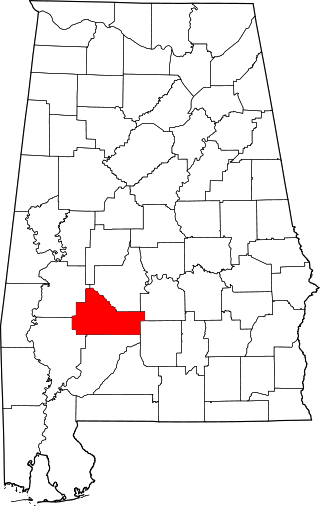
This is a list of the National Register of Historic Places listings in Wilcox County, Alabama.

<span class="mw-page-title-main">National Register of Historic Places listings in Brown County, Wisconsin</span>

This is a list of the National Register of Historic Places listings in Brown County, Wisconsin. It is intended to provide a comprehensive listing of entries in the National Register of Historic Places that are located in Brown County, Wisconsin. The locations of National Register properties for which the latitude and longitude coordinates are included below may be seen in a map.

<span class="mw-page-title-main">National Register of Historic Places listings in Door County, Wisconsin</span>

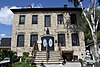
This is a list of the National Register of Historic Places listings in Door County, Wisconsin. It is intended to provide a comprehensive listing of entries in the National Register of Historic Places that are located in Door County, Wisconsin. The locations of National Register properties for which the latitude and longitude coordinates are included below may be seen in a map.

<span class="mw-page-title-main">National Register of Historic Places listings in Ozaukee County, Wisconsin</span>

This is a list of the National Register of Historic Places listings in Ozaukee County, Wisconsin. It is intended to provide a comprehensive listing of entries in the National Register of Historic Places that are located in Ozaukee County, Wisconsin. The locations of National Register properties for which the latitude and longitude coordinates are included below may be seen in a map.

<span class="mw-page-title-main">National Register of Historic Places listings in Crawford County, Wisconsin</span>

This is a list of the National Register of Historic Places listings in Crawford County, Wisconsin. It is intended to provide a comprehensive listing of entries in the National Register of Historic Places that are located in Crawford County, Wisconsin. The locations of National Register properties for which the latitude and longitude coordinates are included below may be seen in a map.

<span class="mw-page-title-main">National Register of Historic Places listings in Ashland County, Wisconsin</span>

This is a list of the National Register of Historic Places listings in Ashland County, Wisconsin. It is intended to provide a comprehensive listing of entries in the National Register of Historic Places that are located in Ashland County, Wisconsin. The locations of National Register properties for which the latitude and longitude coordinates are included below may be seen in a map.

<span class="mw-page-title-main">National Register of Historic Places listings in Marinette County, Wisconsin</span>

This is a list of the National Register of Historic Places listings in Marinette County, Wisconsin. It is intended to provide a comprehensive listing of entries in the National Register of Historic Places that are located in Marinette County, Wisconsin. The locations of National Register properties for which the latitude and longitude coordinates are included below may be seen in a map.

<span class="mw-page-title-main">National Register of Historic Places listings in Lake County, Minnesota</span>

This is a list of the National Register of Historic Places listings in Lake County, Minnesota. It is intended to be a complete list of the properties and districts on the National Register of Historic Places in Lake County, Minnesota, United States. The locations of National Register properties and districts for which the latitude and longitude coordinates are included below, may be seen in an online map.

<span class="mw-page-title-main">National Register of Historic Places listings in Perry County, Ohio</span>

This is a list of the National Register of Historic Places listings in Perry County, Ohio.

<span class="mw-page-title-main">National Register of Historic Places listings in Bayfield County, Wisconsin</span>

This is a list of the National Register of Historic Places listings in Bayfield County, Wisconsin. It is intended to provide a comprehensive listing of entries in the National Register of Historic Places that are located in Bayfield County, Wisconsin. The locations of National Register properties for which the latitude and longitude coordinates are included below may be seen in a map.

<span class="mw-page-title-main">National Register of Historic Places listings in Manitowoc County, Wisconsin</span>

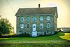
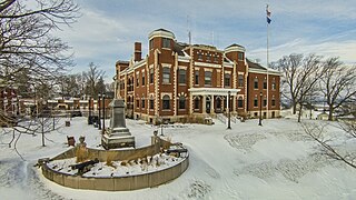
This is a list of the National Register of Historic Places listings in Manitowoc County, Wisconsin. It is intended to provide a comprehensive listing of entries in the National Register of Historic Places that are located in Manitowoc County, Wisconsin. The locations of National Register properties for which the latitude and longitude coordinates are included below may be seen in a map.

<span class="mw-page-title-main">National Register of Historic Places listings in Lafayette County, Wisconsin</span>

This is a list of the National Register of Historic Places listings in Lafayette County, Wisconsin. It is intended to provide a comprehensive listing of entries in the National Register of Historic Places that are located in Lafayette County, Wisconsin. The locations of National Register properties for which the latitude and longitude coordinates are included below may be seen in a map.

<span class="mw-page-title-main">National Register of Historic Places listings in Douglas County, Wisconsin</span>

This is a list of the National Register of Historic Places listings in Douglas County, Wisconsin. It is intended to provide a comprehensive listing of entries in the National Register of Historic Places that are located in Douglas County, Wisconsin. The locations of National Register properties for which the latitude and longitude coordinates are included below may be seen in a map.

<span class="mw-page-title-main">National Register of Historic Places listings in Chippewa County, Wisconsin</span>

This is a list of the National Register of Historic Places listings in Chippewa County, Wisconsin. It is intended to provide a comprehensive listing of entries in the National Register of Historic Places that are located in Chippewa County, Wisconsin. The locations of National Register properties for which the latitude and longitude coordinates are included below may be seen in a map.

<span class="mw-page-title-main">National Register of Historic Places listings in Vilas County, Wisconsin</span>

This is a list of the National Register of Historic Places listings in Vilas County, Wisconsin. It is intended to provide a comprehensive listing of entries in the National Register of Historic Places that are located in Vilas County, Wisconsin. The locations of National Register properties for which the latitude and longitude coordinates are included below may be seen in a map.

<span class="mw-page-title-main">National Register of Historic Places listings in Langlade County, Wisconsin</span>

This is a list of the National Register of Historic Places listings in Langlade County, Wisconsin. It is intended to provide a comprehensive listing of entries in the National Register of Historic Places that are located in Langlade County, Wisconsin. The locations of National Register properties for which the latitude and longitude coordinates are included below may be seen in a map.

<span class="mw-page-title-main">National Register of Historic Places listings in Jackson County, Wisconsin</span>

This is a list of the National Register of Historic Places listings in Jackson County, Wisconsin. It is intended to provide a comprehensive listing of entries in the National Register of Historic Places that are located in Jackson County, Wisconsin. The locations of National Register properties for which the latitude and longitude coordinates are included below may be seen in a map.

<i>Tug Ludington</i> United States historic place

The Tug Ludington is a World War II era tugboat built in 1943 at Jacobson Shipyard in Oyster Bay, New York. The U.S. Army designated the tug LT-4. The tug's armament consisted of two 50 caliber machine guns and participated in the D-Day invasion of Normandy, towing ammunition barges across the English Channel. After World War II, it joined the U.S. Army Transportation Corps until 1947 when the Corps of Engineers transferred the tug to Kewaunee, Wisconsin and then renamed it the Tug Ludington. It was used in the construction and maintenance of many harbors on the Great Lakes and now rests in Harbor Park in Downtown, Kewaunee and is open to visitors for tours. As the Major Wilbur Fr. Browder, the tug is on the National Register of Historic Places listings in Kewaunee County, Wisconsin.

References

  1. The latitude and longitude information provided is primarily from the National Register Information System, and has been found to be fairly accurate for about 99% of listings. For 1%, the location info may be way off. We seek to correct the coordinate information wherever it is found to be erroneous. Please leave a note in the Discussion page for this article if you believe any specific location is incorrect.
  2. National Park Service, United States Department of the Interior, "National Register of Historic Places: Weekly List Actions", retrieved November 10, 2023.
  3. 1 2 Numbers represent an alphabetical ordering by significant words. Various colorings, defined here, differentiate National Historic Landmarks and historic districts from other NRHP buildings, structures, sites or objects.
  4. "National Register Information System". National Register of Historic Places . National Park Service. April 24, 2008.
  5. The eight-digit number below each date is the number assigned to each location in the National Register Information System database, which can be viewed by clicking the number.
  6. Thomsen, Tamara; Meverden, Keith. "America Shipwreck (canaller)" (PDF). National Register of Historic Places Registration Form. National Park Service. Retrieved 2014-08-23.
  7. 1 2 "Historic Algoma Walking Tour - Volume II" (PDF). Community Improvement of Algoma - Main Street Program. Archived from the original (PDF) on 2014-08-26. Retrieved 2012-08-20.
  8. "Daniel Lyons Shipwreck". National Register or State Register. Wisconsin Historical Society. Retrieved 2012-08-20.
  9. Marker in front yard.
  10. "Kewaunee Historical Jail Museum". Kewaunee Area Chamber of Commerce. Retrieved 2012-08-20.
  11. "Kewaunee Pierhead Light". Wisconsin Shipwrecks. Wisconsin Sea Grant & Wisconsin Historical Society. Retrieved 2022-09-12.
  12. "Kewaunee Pierhead Lighthouse". Architecture and History Inventory. Wisconsin Historical Society. Retrieved 2022-09-12.
  13. Lorance, Nancy. "New Deal/WPA Art in Kewaunee, Wisconsin" . Retrieved 2012-08-20.
  14. "Tug Ludington". Kewaunee Area Chamber of Commerce. Retrieved 2012-08-20.
  15. "Ludington". TugboatInformation.com. Retrieved 2012-08-20.
  16. "Marquette Historic District". Kewaunee Area Chamber of Commerce. Retrieved 2012-08-20.
  17. "Melvin W. and Mary Perry House". National Register or State Register. Wisconsin Historical Society. Retrieved 2012-08-20.
  18. "Pilgrim Family Farmstead". Architecture and History Inventory. Wisconsin Historical Society. Retrieved 2014-08-23.
  19. "About St. Lawrence". The Friends of St. Lawrence. Retrieved 2012-08-19.