Ryans Corner, Wisconsin

Last updated

Ryans Corner, Wisconsin
Cropped aerial view of Ryans Corner and vicinity in the town of Casco in Kewaunee County, Wisconsin 2020.png
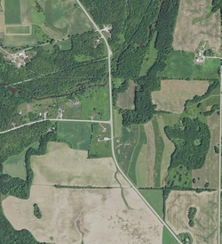
Ryans Corner on August 7, 2020. County Trunk Highway A (left) and County Trunk Highway C make a T-intersection. The Kewaunee River is visible to the north of Ryans Corner, and the Ahnapee State Trail is visible to the north of the river.
USA Wisconsin location map.svg
Red pog.svg
Ryans
Corner
Usa edcp location map.svg
Red pog.svg
Ryans
Corner
Coordinates: 44°30′48″N87°36′28″W / 44.51333°N 87.60778°W / 44.51333; -87.60778
Country Flag of the United States.svg  United States
State Flag of Wisconsin.svg  Wisconsin
County Kewaunee
Town Casco
Elevation
207 m (679 ft)
Time zone UTC-6 (Central (CST))
  Summer (DST) UTC-5 (CDT)
Area code 920
GNIS feature ID1577805 [1]

Ryans Corner is an unincorporated community in the town of Casco, in Kewaunee County, Wisconsin, United States. [2] [1] It was named after a local landowner, T. Ryan. [3] [ failed verification ]

See also

Related Research Articles

<span class="mw-page-title-main">Kewaunee County, Wisconsin</span> County in Wisconsin, United States

Kewaunee County is a county located in the U.S. state of Wisconsin. As of the 2020 census, the population was 20,563. Its county seat is Kewaunee. The county was created in 1852 and organized in 1859. Its Menominee name is Kewāneh, an archaic name for a species of duck. Kewaunee County is part of the Green Bay, WI Metropolitan Statistical Area as well as the Green Bay-Shawano, WI Combined Statistical Area.

<span class="mw-page-title-main">Brown County, Wisconsin</span> County in Wisconsin, United States

Brown County is a county in the U.S. state of Wisconsin. As of the 2020 census, the population was 268,740, making it the fourth-most populous county in Wisconsin. The county seat is Green Bay, making it one of three Wisconsin counties on Lake Michigan not to have a county seat with the same name. Brown County is part of the Green Bay, WI Metropolitan Statistical Area.

<span class="mw-page-title-main">Algoma, Wisconsin</span> City in Wisconsin, United States

Algoma is a city in Kewaunee County in the U.S. state of Wisconsin. The population was 3,167 at the 2010 census. Algoma is part of the Green Bay Metropolitan Statistical Area.

<span class="mw-page-title-main">Kewaunee, Wisconsin</span> City in Wisconsin, United States

Kewaunee is a city in Kewaunee County, Wisconsin, United States. The population was 2,837 at the 2020 census. Located on the northwestern shore of Lake Michigan, the city is the county seat of Kewaunee County. Its Menominee name is Kewāneh, an archaic name for a species of duck.

<span class="mw-page-title-main">Lincoln, Kewaunee County, Wisconsin</span> Town in Wisconsin, United States

Lincoln is a town in Kewaunee County, Wisconsin, United States. The population was 948 at the 2010 census. The unincorporated communities of Lincoln, Gregorville, and Euren are in the town. The unincorporated communities of Rio Creek and Rosiere are also partially in the town.

<span class="mw-page-title-main">Red River, Wisconsin</span> Town in Wisconsin, United States

Red River is a town in Kewaunee County, Wisconsin, United States. The population was 1,393 at the 2010 census, down from 1,476 at the 2000 census. The unincorporated communities of Bay View, Duvall, Frog Station, Thiry Daems, and Tonet are located in the town. The census-designated place of Dyckesville is also located partially in the town.

<span class="mw-page-title-main">Green Bay (town), Wisconsin</span> Human settlement in Wisconsin, United States of America

Green Bay is a town in Brown County in the U.S. state of Wisconsin. The population was 2,035 at the 2010 census. The town is located several miles northeast of the city of Green Bay. The unincorporated community of Champion is located in the town, and the unincorporated communities of Dyckesville and New Franken are located partially in the town.

<span class="mw-page-title-main">Casco, Wisconsin</span> Village in Wisconsin, United States

Casco is a village in Kewaunee County, Wisconsin, United States. The population was 583 at the 2010 census. It is part of the Green Bay Metropolitan Statistical Area. The village is located within the Town of Casco. Casco is named after Casco Bay on the coast of Maine, the previous home of Edward Decker, an early logger in Kewaunee County.

Casco is a town in Kewaunee County, Wisconsin, United States. The population was 1,165 at the 2010 census. The village of Casco, a separate municipality, is in the northwest part of the town, and the unincorporated communities of Clyde, Ryans Corner, Slovan, and Rio Creek are located in the town.

<span class="mw-page-title-main">Luxemburg (town), Wisconsin</span>

Luxemburg is a town in Kewaunee County, Wisconsin, United States. The population was 1,469 at the 2010 census. The village of Luxemburg, a separate municipality, is surrounded by the town. The unincorporated communities of Walhain and Casco Junction are in the town, and Neuern, Frog Station, and Tonet are partially in the town.

<span class="mw-page-title-main">Door Peninsula</span> Peninsula of Wisconsin in Lake Michigan

WDOR-FM is a radio station licensed to Sturgeon Bay, Wisconsin, United States and serving the Sturgeon Bay, Wisconsin area, as well as Door and Kewaunee Counties along with Green Bay to the South.

<span class="mw-page-title-main">East Twin River (Wisconsin)</span>

The East Twin River, formerly the Mishicot River, is a 41.1-mile-long (66.1 km) river in east-central Wisconsin that is a tributary to Lake Michigan. It merges with the West Twin River in the city of Two Rivers at its mouth with the lake. The source of the river is located in central Kewaunee County. On its course it passes through the villages of Mishicot and Tisch Mills. Its tributaries include Jambo Creek and Tisch Mills Creek.

Wisconsin's 8th congressional district is a congressional district of the United States House of Representatives in northeastern Wisconsin. It is currently represented by Mike Gallagher, a Republican. Gallagher won the open seat vacated by Reid Ribble who retired in 2016. It is also one of two Congressional Districts to ever elect a Catholic priest, Robert John Cornell.

<span class="mw-page-title-main">Green Bay metropolitan area</span>

The Green Bay metropolitan statistical area, as defined by the United States Census Bureau, is a metropolitan area in northeastern Wisconsin anchored by the City of Green Bay. It is Wisconsin's fourth largest metropolitan statistical area by population. As of the 2010 Census, the MSA had a combined population of 306,241.

<span class="mw-page-title-main">Tisch Mills, Wisconsin</span> Unincorporated community in Wisconsin, United States

Tisch Mills is an unincorporated community in Kewaunee and Manitowoc counties, Wisconsin, United States. Tisch Mills is located in the towns of Carlton in Kewaunee County and Mishicot in Manitowoc County, 5 miles (8 km) north of the village of Mishicot. It is at an elevation of 636 feet (194 m) above sea level.

The Kewaunee River is a 27.9-mile-long (44.9 km) river in the U.S. state of Wisconsin. It begins near Frog Station in northwest Kewaunee County and flows southeast to empty into Lake Michigan at the city of Kewaunee.

Clyde is an unincorporated community located in the town of Casco, Kewaunee County, Wisconsin, United States. It is on County Highway E near the Kewaunee River, 5.6 miles (9.0 km) northwest of Kewaunee.

<span class="mw-page-title-main">Ahnapee State Trail</span> Multi-use trail in northeastern Wisconsin, Unirted States

The Ahnapee State Trail is a multi-use trail along the Ahnapee River and the Kewaunee River in northeastern Wisconsin.

Black Earth was a village inhabited by Potawatomi, Odawa, and Ojibwe people that was located in the present-day Town of Carlton, Kewaunee County, Wisconsin. Inhabited by Native Americans for several hundred years, Black Earth was one of Wisconsin's Potawatomi communities that continued to exist in the decades after many Potawatomi left Wisconsin under the terms of the 1833 Treaty of Chicago.

References

  1. 1 2 USGS GNIS Feature Detail Report: Ryans Corner
  2. "Ryans Corner Populated Place Profile / Kewaunee County, Wisconsin Data".
  3. Rooney, W. T.; Schleis, A. M. (1895). Map of Kewaunee County, Wisconsin. Kewaunee, Wis.: author.

44°30′48″N087°36′28″W / 44.51333°N 87.60778°W / 44.51333; -87.60778