
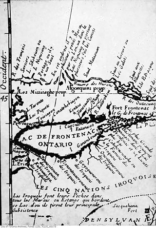
The Wyandot people are an Indigenous peoples of the Northeastern Woodlands of the present-day United States and Canada. Their Wyandot language belongs to the Iroquoian language family.

Scarborough is a district of Toronto, Ontario, Canada. It is situated in the eastern part of the City of Toronto. Its borders are Victoria Park Avenue to the west, Steeles Avenue and the city of Markham to the north, Rouge River and the city of Pickering to the east, and Lake Ontario to the south. Scarborough was named after the English town of Scarborough, North Yorkshire, inspired by its cliffs.
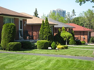
Bendale, also called Cedarbrae and Midland Park, is a residential neighbourhood in the eastern part of Toronto, Ontario, Canada. It is located in the former suburb of Scarborough. It is centred on the intersection of Lawrence Avenue East and Brimley Road. Its boundaries, as defined by the City, are Midland Avenue from Lawrence, north to Highway 401, east to McCowan, south to Lawrence, east to West Highland Creek, south-west along West Highland Creek, then follow several side streets parallel to the Creek, north to Midland Avenue. The area north of Ellesmere is typically considered the Scarborough City Centre district, and is not considered in this neighbourhood article.

The Rouge River is a river in Markham, Pickering, Richmond Hill and Toronto in the Greater Toronto Area of Ontario, Canada. The river flows from the Oak Ridges Moraine to Lake Ontario at the eastern border of Toronto, and is the location of Rouge Park, the only national park in Canada within a municipality. At its southern end, the Rouge River is the boundary between Toronto and southwestern Pickering in the Regional Municipality of Durham.
Port Union, also known as Centennial Scarborough is a neighbourhood in Toronto, Ontario, Canada. It is located in the south-east corner of Toronto, within the former suburb of Scarborough. The neighbourhood is bounded by Kingston Road to the north, Port Union Road to the east, the Lake Ontario shoreline to the south, and Highland Creek to the west.

Brimley Road is a north-south street in Toronto and the Regional Municipality of York, Ontario, Canada. In Toronto, it is located entirely within Scarborough and carried 32000 vehicles daily in May 2007 Hence, it is classified as a major arterial road by the city of Toronto.

Milliken and Milliken Mills are neighbourhoods in the cities of Toronto and Markham. Milliken is situated in the north west section of Scarborough, whereas Milliken Mills is situated in the south-central portions of Markham. The neighbourhoods are centered on Kennedy Road and Steeles Avenue, the latter street serving as the boundary between the cities of Markham and Toronto.

Steeles is a suburban neighbourhood in Toronto, Ontario, Canada. Steeles is located in the north-eastern part of Toronto in the former suburb of Scarborough. To the north is bordered by Steeles Avenue East, to the east by Kennedy Road, to the south by a hydro-electric transmission line and to the west by Victoria Park Avenue.

Tam O'Shanter-Sullivan is a neighbourhood in the east end of the city of Toronto, Ontario, Canada, in the district of Scarborough. The neighbourhood is bordered by Huntingwood Drive to the North, Kennedy Road to the East, Highway 401 to the South and Victoria Park to the West. The neighbourhood, which includes the Tam O'Shanter and Sullivan communities, takes its name from Tam O’Shanter Golf Course and O'Sullivan's Corners.

Woburn is a neighbourhood located in eastern Toronto, Ontario, Canada, in the former suburb of Scarborough. Woburn is bordered by Highway 401 to the north, Orton Park Road to the east, Lawrence Avenue to the south, and McCowan Road to the west. A sub-neighbourhood, which compromises the eastern section of Woburn, named Curran Hall, borders Highland Creek river to the east, Lawrence Avenue to the south, Scarborough Golf Club Road to the west and Ellesmere Road to the north.

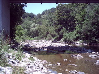
Highland Creek is a river in the Scarborough district of Toronto, Ontario, emptying into Lake Ontario at the eastern end of the Scarborough Bluffs. It is home to several species of fish including trout, carp, bass and salmon. It is a meandering river which, like most rivers in Toronto, travels through a glacial ravine formed after the last Ice Age. The Highland Creek watershed, including tributaries, is almost entirely contained within Scarborough.
West Highland Creek is a river in Toronto, Ontario, Canada, and is a tributary of Highland Creek in the Lake Ontario drainage basin. The creek and its tributaries are entirely within the old City of Scarborough, and provide the watershed for the northwest of the city.

Taber Hill, also spelled Tabor Hill, is a Wyandot (Huron) burial mound in Toronto, Ontario. It is located northeast of the intersection of Lawrence Avenue and Bellamy Road in Scarborough. It is estimated to date from the 14th century and contain the skeletons of over 500 Huron/Wendat. It is believed to be the only First Nations ossuary protected as a cemetery in Canada.

The "Jean-Baptiste Lainé" or Mantle Site in the town of Whitchurch–Stouffville, north-east of Toronto, Ontario, Canada, is the largest and most complex ancestral Wendat-Huron village to be excavated to date in the Lower Great Lakes region. The site's southeastern access point is at the intersection of Mantle Avenue and Byers Pond Way.
The Draper Site is a precontact period Huron-Wendat ancestral village located on a tributary of West Duffins Creek in present-day Pickering, Ontario, approximately 35 kilometres northeast of Toronto. The site is found in a wooded area on existing farmland and may be reached by walking from the end of North Road.

The Aurora Site, also known as the "Old Fort", "Old Indian Fort", "Murphy Farm" or "Hill Fort" site, is a sixteenth-century Huron-Wendat ancestral village located on one of the headwater tributaries of the East Holland River on the north side of the Oak Ridges Moraine in present-day Whitchurch–Stouffville, approximately 30 kilometres north of Toronto. This Huron ancestral village was located on 3.4 hectares of land and the settlement was fortified with multiple rows of palisades.

The Ratcliff or Baker Hill Site is a 16th-century Huron-Wendat ancestral village located on one of the headwater tributaries of the Rouge River on the south side of the Oak Ridges Moraine in present-day Whitchurch–Stouffville, approximately 25 kilometers north of Toronto. The Ratcliff Site is located on the east side of Highway 48, south of Bloomington Road in Whitchurch–Stouffville. The ravine on the village site was infilled during the early 1950s to allow for the expansion of a neighboring quarry.
Bead Hill is an archaeological site comprising the only known remaining and intact 17th-century Seneca site in Canada. It is located on the banks of the Rouge River in Rouge Park, a national park in Toronto, Ontario. Because of its sensitive archaeological nature, it is not open to the public, nor readily identified in the park. It was designated a National Historic Site in 1991, eventually becoming a unit of the national park system in June 2019.

