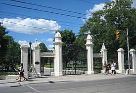
Trinity Bellwoods Park

Last updated

Trinity Bellwoods Park
Trinity Bellwoods Gates.jpg
The gates at the southern entrance to the park
Toronto map.svg
Red pog.svg
Location of Trinity Bellwoods Park in Toronto
Typepublic park
Location Toronto, Ontario, Canada
Coordinates 43°38′52″N79°24′51″W / 43.64778°N 79.41417°W / 43.64778; -79.41417
Operated byCity of Toronto

Trinity Bellwoods Park is a public park located in Toronto, Ontario, Canada, bordered by Queen Street West on the south and Dundas Street on the north. The western boundary of the park is Crawford Street, several hundred feet before Crawford intersects with Dundas St. West, the park juts toward Shaw Street, westside of the Crawford Street Bridge. Most of the park's area lies in the original Garrison Creek ravine and this creek, now a buried city storm sewer, still flows beneath the park from the northwest to the southeast corners.

Contents

History

Looking south towards the gates and Queen Street West in 1913 Oldtringates.jpg
Looking south towards the gates and Queen Street West in 1913

The old Garrison Creek emptied into Lake Ontario at the site of Fort York, and the land north and west of the fort was set aside as a military reserve. As the town of York grew around the fort, the military reserve was gradually sold off in lots to retiring British officers and friends of the military command. Samuel Smith was granted 100 acres (0.40 km2) of land in 1806, which he called Gore Vale after Lieutenant Governor Francis Gore; [1] "vale" referred to Garrison Creek ravine. A portion of Smith's grant later became the park. [1]

When the park was first created (after 1900) it was referred to as Bellwoods Park in the 1903 Goad's Map with a nearby street named Bellwoods Avenue. [2] The Bellwoods name is believed to be associated to former alderman William Bell, who served St. Stephen's Ward from 1881 to 1883 and again from 1888 to 1896.

Kivas Tully's Trinity College building, c. 1851 TrinBellwood.jpg
Kivas Tully's Trinity College building, c. 1851

Much of the current parkland was originally purchased from Janet Cameron (sister of Lieutenant Colonel Duncan Cameron C.B. whom first lived here) [3] of Gore Vale in 1851 by Scottish-Canadian Bishop John Strachan, an influential Anglican cleric who wanted Toronto to have a private college with strong Anglican ties, partly in opposition to the recently secularized University of Toronto. Buildings were soon constructed (Gothic Revival structure by architect Kivas Tully) and students began attending Trinity College in 1852. After federation with the University of Toronto in 1904 and completion of the downtown Trinity campus in 1925, the school left this location. The original buildings were then sold to the City of Toronto and most were demolished in the early 1950s. The destruction of the Trinity buildings marked the beginning of two decades of extensive heritage destruction in Toronto. Of the college itself, only the stone gates now remain, [4] at the Queen Street park entrance facing south on Strachan Avenue, although the former St. Hilda's College building from 1899, (the women's residence of Trinity College) still overlooks the northern half of the park on the western edge. It is now a seniors' residence, John Gibson House. The iron gates are replica with original now installed at Trinity College School entrance on Deblaquire Street North in Port Hope, Ontario.

In the 1950s, Garrison Creek was entirely buried and the creek ravine backfilled around the Crawford Street Bridge with displaced soil from the new Bloor-Danforth subway line, raising the surface of the northern end of the park to almost the height of Dundas Street. The steep drop from this upper level to the lower part of the park has become a popular local toboggan run in winter. The larger southern part of the 'bowl' is the largest designated dogs 'off-leash' park. Picnic tables are also provided here for summertime use and public washroom facilities. There is a historical plaque the commemorates the bridge buried under this stretch of Crawford, just south of Dundas West.

In 2001, the Friends of Trinity Bellwoods Park was formed to coordinate volunteer activities and provide input to the city on park management. It is made up of volunteer community members

Features

View of the park with the CN Tower in the background Trinity Bellwoods Park 2022.jpg
View of the park with the CN Tower in the background
Cherry blossom in the park Trinity Bellwoods Park Cherry blossom 2022.jpg
Cherry blossom in the park
Trinity Bellwoods Park Hockey Rink Trinity Bellwoods Park-1 2022.jpg
Trinity Bellwoods Park Hockey Rink

The park is 15.4 hectares (38 acres). [5] [6] It has a community recreation centre, managed and owned by the City of Toronto, called Trinity CRC, located at 155 Crawford Street on the west side of the park. It has two indoor pools, gymnasium, fitness centre, indoor walking/running track and multi-purpose rooms. Adjacent to the centre, in the park, are a volleyball court, large playground, and children's outdoor wading pool. Also in the park are eight outdoor tennis courts located in the south-east corner and an outdoor ice skating rink at the north-east boundary and volleyball court just north of the Rec Centre. There is also field space for soccer, football, and rugby, as well as three softball fields along the east boundary. Toronto Parks, Forestry and Recreation Division maintain a marked Discovery Walk and shared pedestrian/cycling trail above and parallel to Garrison Creek, which runs through the park from the northwest to the southeast. Trinity Bellwoods is a favourite place for local residents to walk their dogs. The ravine, known as the dog bowl, is the designated leash-free area. The park is a destination for many to picnic, play sports, and enjoy nature. The park's baseball diamond is officially named SkyDome in reference to the popular former name of the Rogers Centre. [7]

The park is home to white squirrels, the subject of urban folklore in the city. The Toronto Special news magazine featured White Squirrel hunts in a past issue. The true albino squirrels have pink eyes. It is deemed good luck to have spotted one, or two. As there are families of them.

The diverse variety of native and imported trees planted throughout the park, in various stages of growth from young to mature, provide a brilliant display of fall colour against the deep green grass. The Friends of Trinity Bellwoods Park run the volunteer Adopt-a-tree program (originated by the Friends) that helps insure the survival of newly planted trees. The emerald ash borer beetle is slowly infesting the trees and succession planting and Parks, Forestry and Recreation have been aggressively planting every year to replace the many that are designated to be cut down because of this beetle. In winter the night view of the Toronto skyline rising above the ravine is extraordinarily beautiful, especially looking east from the Discovery Walk pathway near the western boundary. Tall black Victorian-style iron lamp poles along the main paths provide safe but soft illumination and a charming touch of character.

Events and activities

Trinity Bellwoods has been the site of many recent cultural events, including outdoor movie nights, an anarchist bookfair, live theatre, performance art, and informal summer drumming circles. In June 2007 a weekly farmers' market opened in the northwest corner of the park, at Shaw and Dundas.[ citation needed ]

In the northwest corner of the park there is a small reminder of the diverse Latin American character of other nearby neighbourhoods: a bust of Simón Bolívar which was donated to the city. This is where the Trinity Bellwoods Farmers' Market is located.

It was originally chosen as the site of the G20 protests on June 26–27, 2010, but Toronto Police announced that they would use the area north of Queen's Park instead after local residents opposed the use of Trinity Bellwoods Park as a protest site. [8]

2021 clearing

In 2021, police cleared between 20 and 25 people who had been camping in the park. [9] [10] [11] Notices had been posted to vacate, but after a COVID-19 outbreak in a shelter hotel. [12]

References in culture

Treble Charger wrote a song called Trinity Bellwoods, which was on their debut album NC17. The 2010 film Scott Pilgrim vs. the World had a scene filmed here. [13]

Toronto-based artist organization Humble Empire created the "Live In Bellwoods" series of videos featuring acoustic performances by popular artists living in or visiting Toronto. Each video highlights a different area of the park. Dave Monks from Tokyo Police Club, Luke Lalonde from Born Ruffians, and Chris White of Bellewoods were among the performers to be featured in the series.

See also

Related Research Articles

<span class="mw-page-title-main">Francis Gore</span> Canadian politician

Francis Gore, was an English military officer and British colonial administrator in Bermuda and Upper Canada.

<span class="mw-page-title-main">Trinity—Spadina</span> Former Canadian federal electoral district

Trinity—Spadina was a federal electoral district in Ontario, Canada, that was represented in the House of Commons of Canada from 1988 to 2015.

<span class="mw-page-title-main">Garrison Creek (Ontario)</span> River in Ontario, Canada

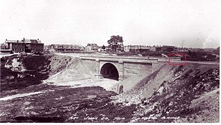
Garrison Creek was a short stream about 7.7 kilometres (4.8 mi) long that flowed southeast into the west side of Toronto Harbour in Ontario, Canada. It has been largely covered over and filled in, but geographical traces of the creek can still be found, including the natural amphitheatre known as Christie Pits and the off-leash dog "bowl" of Trinity Bellwoods Park. The name "Garrison Creek" was used because Fort York was built near the creek mouth. Volunteers lead popular tours of the course of the old watershed.

<span class="mw-page-title-main">Bloor Street</span> Major thoroughfare in Toronto

Bloor Street is a major east–west residential and commercial thoroughfare in Toronto, Ontario, Canada. Bloor Street runs from the Prince Edward Viaduct, which spans the Don River Valley, westward into Mississauga where it ends at Central Parkway. East of the viaduct, Danforth Avenue continues along the same right-of-way. The street, approximately 25 kilometres (16 mi) long, contains a significant cross-sample of Toronto's ethnic communities. It is also home to Toronto's famous shopping street, the Mink Mile.

<span class="mw-page-title-main">College Street (Toronto)</span> Street in Toronto, Ontario, Canada

College Street is a principal arterial thoroughfare in downtown Toronto, Canada, connecting former streetcar suburbs in the west with the city centre. The street is home to an ethnically diverse population in the western residential reaches, and institutions like the Ontario Legislature and the University of Toronto in the downtown core. At Yonge Street, College continues to the east as Carlton Street.

<span class="mw-page-title-main">Cedarvale Park (Toronto)</span> Park in Toronto, Ontario, Canada

Cedarvale Park is a park located in Toronto, Ontario, Canada. It is bordered by very steep hills, and is located in the Cedarvale neighbourhood of Toronto. The Line 1 Yonge–University subway tunnels underneath it, between St. Clair West and Eglinton West stations; near the Markdale TTC Emergency Exit. The north end of the park contains the Phil White (Cedarvale) Arena and The Leo Baeck Day School, formerly Arlington Middle School. It is commonly used for dog walkers and students returning from the nearby school. The large open fields are heavily used by the community for everything from cricket games to flying kites. In the winter the large hill is used for tobogganing, many people bring their sleds and enjoy riding down the hills.

<span class="mw-page-title-main">Dufferin Grove Park</span> Public park in Toronto, Ontario, Canada

Dufferin Grove Park is a park in the Dufferin Grove neighbourhood of Toronto, Ontario, Canada. The park is located on the east side of Dufferin Street, south of Bloor Street West. It is located a block south of the Dufferin subway station and across the street from Dufferin Mall. The park extends two city blocks east and is primarily green-space with mixed open space and treed areas.

<span class="mw-page-title-main">Lambton, Toronto</span> Neighbourhood in Canada

Lambton is a neighbourhood in the city of Toronto, Ontario, Canada. It is situated on the east bank of the Humber River north and south of Dundas Street West. It is bounded on the north by Black Creek, on the east by Jane Street and on the south by St. Mark's Road. The area west of Gooch Avenue and south of Dundas Street West is also known as "Warren Park", the name of the housing sub-division built in the 1950s. The portion south of Dundas Street West is within the 'Lambton Baby Point' neighbourhood as defined by the City of Toronto.

<span class="mw-page-title-main">Discovery District</span> Neighbourhood in Toronto, Ontario, Canada

The Discovery District is one of the commercial districts in Downtown Toronto, Ontario, Canada. It has a high concentration of hospitals and research institutions, particularly those related to biotechnology. The district is roughly bounded by Bloor Street on the north, Bay Street on the east, Dundas Street on the south, and Spadina Avenue on the west.

<span class="mw-page-title-main">Alexandra Park, Toronto</span> Neighbourhood in Toronto, Ontario, Canada

Alexandra Park is a neighbourhood located in downtown Toronto, Ontario, Canada. Alexandra Park is bounded by Dundas Street West on the north, Spadina Avenue on the east, Queen Street West on the south, and Bathurst Street on the west. Alexandra Park consists of private and public housing, with at grade retail along Queen Street West and Spadina Avenue, some institutional, and several commercial buildings scattered through the neighborhood. The neighborhood takes its name from Alexandra Park, a municipal park at the south-east corner of Dundas Street West and Bathurst Street. The park is named for Queen Alexandra, whose husband, King Edward VII, was the first future monarch to visit Toronto.

<span class="mw-page-title-main">Ossington Avenue</span> Thoroughfare in Toronto, Ontario

Ossington Avenue is a main or arterial street in Toronto, Ontario, Canada, west of downtown. While the northern 3 kilometres (1.9 mi) of Ossington Avenue is residential, its southern terminus is popularly known as the Ossington Strip, an area popular for its dining, nightlife and shopping establishments.

<span class="mw-page-title-main">Crawford Street Bridge</span> Bridge in Ontario, Canada

<span class="mw-page-title-main">Harbord Street Bridge</span> Bridge in Toronto, Canada

The Harbord Street Bridge is one of two known bridges that once spanned Harbord Street over Garrison Creek in Toronto and was partially buried intact in the 20th Century.

<span class="mw-page-title-main">Trinity-Bellwoods</span> Neighbourhood in Toronto, Ontario, Canada

Trinity-Bellwoods is an inner city neighbourhood in Toronto, Ontario, Canada. It is bounded on the east by Bathurst Street, on the north by College Street, on the south by Queen Street West, and by Dovercourt Road on the west. It has a large Portuguese and Brazilian community, and many local Portuguese-Canadian businesses are located along Dundas Street West, continuing west into Little Portugal; this stretch further west along Dundas is known as Rua Açores.

<span class="mw-page-title-main">Yellow Creek (Toronto)</span> Stream in Ontario, Canada

Yellow Creek is a partially-buried southeasterly tributary of the Don River in Toronto. It has also been known at different times as Silver Creek, Sylvan Creek, and Rosedale Brook. The former source of Yellow Creek begins near Sheppard West station in the Downsview neighbourhood. Most of the creek and its sources are buried underground in storm sewers until they emerge into Avoca Ravine in the Deer Park neighbourhood and continue their way to the Don River.

<span class="mw-page-title-main">David A. Balfour Park</span>

David A. Balfour Park is an urban park in the Deer Park neighbourhood of Toronto near the intersection of Yonge Street and St. Clair Avenue. The park made up of 20.5 hectares of green space consisting of the greenery-covered Rosehill Reservoir and the entirety of the Vale of Avoca with its system of trails.

<span class="mw-page-title-main">Dundas Street</span> Major arterial road in Ontario, Canada

Dundas Street is a major historic arterial road in Ontario, Canada. The road connects the city of Toronto with its western suburbs and several cities in southwestern Ontario. Three provincial highways—2, 5, and 99—followed long sections of its course, although these highway segments have since been downloaded to the municipalities they passed through. Originally intended as a military route to connect the shipping port of York to the envisioned future capital of London, Ontario, the street today connects Toronto landmarks such as Yonge–Dundas Square and the city's principal Chinatown to rural villages and the regional centres of Hamilton and London.

The COVID-19 pandemic made homelessness in Toronto more visible, due to the rise of encampments in public parks. However, homelessness in Canada had been an issue of widespread concern long before the pandemic's arrival. A 2016 report found that at least 235,000 Canadians experience homelessness in a year, and 35,000 Canadians experience it on a given night. A Nanos survey found in 2020 that 72% of Canadians believed it was urgent to work toward ending homelessness in Canada. A 2020 report from the Wellesley Institute argues that there were disproportionately higher rates of evictions in Black neighborhoods, and that Black residents were among the worst hit by COVID-19. As part of its stay at home order in March 2020, the Ontario government instated a ban on evictions, however this was lifted with the emergency order in June 2020. The Ontario government however made evictions easier, according to some critics, due to its passage of Bill 184 which allowed landlords to bypass the Landlord and Tenant Board. One advocacy group deemed the cascading effects of Bill 184 'a bloodbath of evictions'. By December 2020, Toronto tenants were calling for a reinstatement of the moratorium on evictions. The crisis conditions of the pandemic lead to an increase in organizing against what many homelessness advocates deemed to be social murder of the city's unhoused. This ranged from legal lawsuits against the city's shelter system to calls for a city plan that would address the large numbers of unhoused people camping outside, to suits against encampment evictions, to large scale protests against the clearings of public parks. The Covid-19 encampments are best understood as emerging out of a longer history of urban informality in Toronto.

References

  1. 1 2 Wise, Leonard A. (2000). Toronto Street Names: An Illustrated Guide to Their Origins. Firefly Books. p.  101. ISBN   1-55209-386-7. OCLC   46937771.
  2. "This is what Trinity Bellwoods Park looked like a century ago". www.blogto.com.
  3. "Gore Vale". www.lostrivers.ca.
  4. Dendy, William (1978). Lost Toronto. Oxford University Press. p.  127. ISBN   0-19-540294-4.
  5. "Parks, Forestry and Recreation : Trinity Bellwoods Park". Toronto.ca. Retrieved November 1, 2016.
  6. "Toronto Parks: Trinity Bellwoods Park". Blogto.com. July 24, 2012. Retrieved November 1, 2016.
  7. "The Skydome in Trinity Bellwoods Park has finally been recognized".
  8. "Police chief reconfirms that Queen's Park will be designated protest area during G20". CP24.com. May 11, 2010. Retrieved November 1, 2016.
  9. Canada, To Do (June 22, 2021). "Police, Community Clash as Toronto Moves to Clear Homeless Encampment in Park". To Do Canada. Retrieved June 26, 2021.
  10. "Toronto mayor to review clearing of homeless encampment from Trinity Bellwoods". CBC.{{cite web}}: CS1 maint: url-status (link)
  11. ICI.Radio-Canada.ca, Zone Politique-. "Échauffourées lors du démantèlement d'un campement de sans-abri". Radio-Canada.ca (in Canadian French). Retrieved June 26, 2021.
  12. "Toronto pauses plans to clear encampments after COVID-19 outbreak declared at shelter hotel". CBC.{{cite web}}: CS1 maint: url-status (link)
  13. "Scott Pilgrim vs. Keeping Toronto Anonymous! « CanadianCultureThing". Archived from the original on March 12, 2012. Retrieved 2012-12-06.