Riverdale Park (Toronto)

Last updated
Riverdale Park
Riverdale Park Toronto.jpg
Riverdale Park, looking south
Toronto map.png
Red pog.svg
Location of the park in Toronto
TypePublic Park
Location Toronto, Ontario
Coordinates 43°40′11″N79°21′20″W / 43.669827°N 79.355428°W / 43.669827; -79.355428 Coordinates: 43°40′11″N79°21′20″W / 43.669827°N 79.355428°W / 43.669827; -79.355428
Area104 acres (42 ha)
Created1880 (1880)
Operated byCity of Toronto

Riverdale Park is a large park spanning the Lower Don River in Toronto, Ontario, Canada, between Cabbagetown to the west and Broadview Avenue in Riverdale to the east.

Contents

Description

The park has recreational fields for soccer, baseball, and Ultimate on both sides of the river. There is also a swimming pool, tennis courts and outdoor hockey rink to the northeast, and a running track in the centre. A footbridge crosses the Don Valley Parkway, Bayview Avenue, the Canadian National Railway Bala subdivision tracks, and the river and joins the two sides of the valley as well as the Lower Don Recreational Trail that follows the river. The bridge is located near the site of a butternut tree bridge built by Ely Playter that provided access to his property and mill around the 1790s. The bridge is depicted by Elizabeth Simcoe's watercolour painting Playter's Bridge near York, ca. 1796. [1]

At the south-east corner of the park is Bridgepoint Hospital and a monument to Sun Yat-Sen. Immediately to the west of the park in Cabbagetown is Riverdale Farm, a city operated, publicly accessible farm.

In the summer, a free movie series takes place in the park. According to its website, "Everyone is welcome ~ Bring a picnic, friends and family to enjoy great PG rated films under the stars. All the films begin at dusk" [2]

Riverdale Park, Toronto, Ontario - panorama.jpg
Riverdale Park

History

The land on the east side of the Don River was originally owned by John Scadding, one of the early settlers to Toronto and the estate manager and clerk for John Graves Simcoe, Governor of Upper Canada. John Scadding's cabin, built in 1794 just south of the present day park, was relocated to the grounds of the Canadian National Exhibition in 1879. 120 acres (49 ha) of Scadding's farm property had been purchased by the City of Toronto in 1856 for the Don Jail, and the rest of the lands opened as a park in 1880. The park acquired a 32-pounder cannon from Quebec City and since relocated to Marie Curtis Park. [3] More land was added later to bring the park up to 162 acres (66 ha) in size, but the construction of the Don Valley Parkway in the 1960s reduced this to the current figure of 104 acres (42 ha). [4] On Broadview Avenue east of the park is John Cox Cottage, an 1807 log home.

In 1886, road construction immediately east of the park uncovered artifacts of a First Nations settlement or encampment on the area above the valley. A small number of artifacts are on display in a display case at Withrow Avenue Junior Public School. A plaque is affixed to the main entrance of the school on Bain Avenue. [5]

Cricket in Riverdale Park, 1923 Cricket in Riverdale Park in Toronto.jpg
Cricket in Riverdale Park, 1923

The eastern side of the park was also used as a landfill in the 1920s. A walk along Broadview Avenue shows the evidence of this in the form of green exhaust pipes to vent the methane gas from the former dump beneath the park. [6]

In the 1970s, the park was the original site proposed for a new 40,000 seat stadium, a project that would eventually become SkyDome. The plan was eventually abandoned, in part due to the strong objections of local Alderman John Sewell. [7]

In 1990, a grassy slope on the eastern side was planted with trees. This was the first public event hosted by the Task Force to Bring Back the Don. The slope is now moderately forested with trees averaging 3–4 metres in height. In 2002, Bring Back the Don created a small marsh at the bottom of the slope. Water collects there from the slope as well as from adjacent playing fields. Other restoration projects include trees planted along a berm adjacent to the Don Valley Parkway.

Related Research Articles

Don River (Ontario) River in Canada

The Don River is a watercourse in southern Ontario, that empties into Lake Ontario, at Toronto Harbour. Its mouth was just east of the street grid of the town of York, Upper Canada, the municipality that evolved into Toronto, Ontario. The Don is one of the major watercourses draining Toronto that have headwaters in the Oak Ridges Moraine.

Cabbagetown, Toronto Neighbourhood in Toronto, Ontario, Canada

Cabbagetown is a neighbourhood in central Toronto, Ontario, Canada. Administratively, it is defined as part of the Cabbagetown-South St. Jamestown neighbourhood. It largely features semi-detached Victorian houses and is recognized as "the largest continuous area of preserved Victorian housing in all of North America", according to the Cabbagetown Preservation Association.

Don Valley Parkway Toronto municipal expressway

The Don Valley Parkway (DVP) is a municipal expressway in Toronto, Ontario, Canada, which connects the Gardiner Expressway in downtown Toronto with Highway 401. North of Highway 401, it continues as Highway 404. The parkway runs through the parklands of the Don River Valley, after which it is named. It has a maximum speed limit of 90 km/h (56 mph) for its entire length of 15.0 km (9.3 mi). It is six lanes for most of its length, with eight lanes north of York Mills Road and four lanes south of Eastern Avenue. As a municipal road, it is patrolled by the Toronto Police Service.

Riverdale, Toronto Neighbourhood in Toronto, Ontario, Canada

Riverdale is a large neighbourhood in Toronto, Ontario, Canada. It is bounded by the Don River Valley to the west, Danforth Avenue and Greektown to the north, Jones Avenue, the CN/GO tracks, Leslieville to the east, and Lake Shore Boulevard to the south.

Gerrard Street (Toronto) thoroughfare in Toronto, Ontario

Gerrard Street is a street in Toronto, Ontario, Canada. It consists of two separate parts, historically referred to as Lower Gerrard and Upper Gerrard. The former stretches between University Avenue and Coxwell Avenue for 6 km, across Old Toronto. The latter portion starts 300 m north of Lower Gerrard's eastern terminus and runs between Coxwell Avenue and Clonmore Drive, between Victoria Park Avenue and Warden Avenue, in Scarborough for another 4 km.

Sunlight Park Former baseball stadium in Toronto, Canada

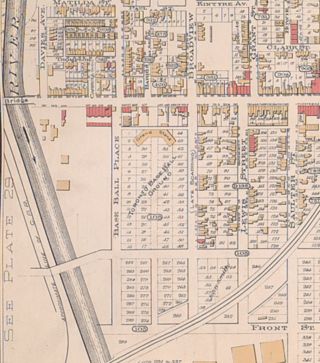
Sunlight Park was the first baseball stadium in Toronto, Ontario, Canada. The all wood structure was built in 1886 at a cost of $7,000 by the International League baseball team the Toronto Baseball Club.

Broadview station Toronto subway station

Broadview is a subway station on Line 2 Bloor–Danforth in Toronto, Ontario, Canada. The entrance to the building is from Broadview Avenue just north of Danforth Avenue.

Danforth Avenue Arterial street in Toronto

Danforth Avenue and Danforth Road are two historically-related arterial streets in Toronto, Ontario, Canada. Danforth Avenue is an east–west street that begins in Old Toronto at the Prince Edward Viaduct as a continuation of Bloor Street and continues for about 6 kilometres (3.7 mi) east through old Toronto, about 350 metres (1,150 ft) of old East York, and a further 5 kilometres (3.1 mi) in Scarborough until intersecting with Kingston Road via a ramped interchange. Danforth Road splits off the Avenue west of Warden Avenue, and runs diagonally northeast until south of Lawrence Avenue, where it continues as McCowan Road.

Bayview Avenue Major north-south route in the Greater Toronto Area of Ontario

Bayview Avenue is a major north–south route in the Greater Toronto Area of Ontario. North of Toronto, in York Region, Bayview is designated as York Regional Road 34.

German Mills Unincorporated community in Ontario, Canada

German Mills is a community within the city of Markham in Ontario, Canada. The easternmost community in the historic town of Thornhill, German Mills was named for the early German settlers in the area.

Playter Estates Neighbourhood in Toronto, Ontario, Canada

Playter Estates is an area in the east end of Toronto, Ontario, Canada bounded by Jackman Avenue to the east, the Don River Valley to the west, Danforth Avenue in the south, and Fulton Avenue in the north. The neighbourhood is built on land once owned by the Playter family for whom two streets in the area are named. The old farmhouse of the Playter household at 28 Playter Crescent is now the Playter Mansion, which is often used for various films, television shows, and commercials.

John Scadding was an early settler in York, Upper Canada. John Scadding is remembered via the Scadding Cabin, the oldest building in Toronto. He served as a clerk to Upper Canada's first Lieutenant Governor John Graves Simcoe.

Castle Frank Brook

Castle Frank Brook is a buried creek and south-west flowing tributary of the Don River in central and north-western Toronto, Ontario, originating near the intersection of Lawrence Avenue and Dufferin Street.

Withrow Park Park in Toronto

Withrow Park is a 8.5-hectare (21-acre) park in the Riverdale neighbourhood of Toronto, Ontario, Canada. Laid out and constructed in the 1910s, at the same time that the surrounding community was built, Withrow Park is among Toronto's large multi-purpose parks. The park is bounded by Carlaw Avenue on the east, Bain Avenue on the south, Logan Avenue on the west and McConnell Avenue on the north.

Parliament Street (Toronto)

Parliament Street is a north-south street in the eastern part of downtown Toronto, Ontario, Canada. The street runs from Bloor Street to Queens Quay and is the first major street west of the Don River.

John Cox Cottage

John Cox Cottage, at 469 Broadview Avenue, Toronto, Ontario, Canada, is the oldest known house in the city still used as a residence, and it still resides on its original site. The property, immediately to the east of what was John Scadding's original lot, was deeded to John Cox by Governor Simcoe in 1796.

Dundas Street Major arterial road in southwestern Ontario

Dundas Street is a major historic arterial road in Ontario, Canada. The road connects the city of Toronto with its western suburbs and several cities in southwestern Ontario. Three provincial highways—2, 5, and 99—followed long sections of its course, although these highway segments have since been downloaded to the municipalities they passed through. Originally intended as a military route to connect the shipping port of York to the envisioned future capital of London, Ontario, the street today connects Toronto landmarks such as Yonge-Dundas Square and the city's principal Chinatown to rural villages and the regional centres of Hamilton and London.

References

  1. "Playter's Bridge near York, ca. 1796". YorkSpace. York University. Retrieved 2012-08-06.
  2. "About-Movies in the Park". Riverdale Park. Movies in the Park. 2013. Retrieved 2013-09-26.
  3. Purvis, Fred. "Secret Lives of Toronto's Guns". Fife and Drum. 9 (4): 7.
  4. "Riverdale Park". Points of interest. Don Valley Historical Mapping Project. Retrieved 2012-08-06.
  5. "The Withrow Archaeological Site Centennial of Discovery 1886-1986". torontohistory.org. Retrieved November 1, 2016.
  6. "Planted along the Broadview Avenue edge of Riverdale Park are 20-odd numbered green posts. What are they?". Urban Decoder. Toronto Life. 2005-06-01. Retrieved 2012-08-06.
  7. "Metrodome in Park Called "Unthinkable"". Toronto Star. July 7, 1970.