Milne Hollow

Last updated
Milne Hollow
Toronto map.png
Red pog.svg
Location of the park in Toronto
TypePublic Park
Location Toronto, Ontario
Coordinates 43°44′21″N79°20′04″W / 43.7391575°N 79.3344418°W / 43.7391575; -79.3344418 Coordinates: 43°44′21″N79°20′04″W / 43.7391575°N 79.3344418°W / 43.7391575; -79.3344418
Operated byCity of Toronto

Milne Hollow is a 50-hectare (120-acre) valley site in Toronto, Ontario, Canada within the valley of the East Don River. It is located in north-west central Toronto where the Don Valley Parkway intersects with Lawrence Avenue East. It was the location of pioneer Alexander Milne's mill town known as Milnesford Mills and his homestead farm. Today it is dominated by transportation uses, (including two rail lines, an expressway and an arterial road) with parkland alongside. The parkland has seen recent naturalization efforts by the City of Toronto government and volunteer organizations, including the opening of the East Don Trail in 2012.

Contents

Description

Milne Hollow is a wide section of the valley of the East Don River. It was first inhabited by Europeans in the 19th century. The Milne family set up a pioneer farm and mill on the river. The river itself flows from the north-west to the south-east of the hollow. To the north-west and south-east, the river floodplains are forested. Along the south and west slopes of the hollow, the Canadian National rail line crosses the hollow, following the river valley. Along north-south lines, the Don Valley Parkway descends into the hollow where a large interchange exists for access to Lawrence Avenue, an arterial road crossing the hollow on an east-west direction.

Other than transportation uses, the hollow is in a natural state. In the south-east quadrant is Moccasin Creek Park. Along the river, and occupying the east bank of the river and the south-east quadrant of the valley is the Charles Sauriol Conservation Reserve, which continues to the south-east along the East Don River.

Milnesford Mills

The small village of Milneford Mills was located along Lawrence Avenue at its crossing of the river. The Milne family moved to the site in 1832, moving its mill operations from the Milne farm located further to the west (the property known as Edwards Gardens today), due to low flows of water. [1] In 1846, Milne built a woolen mill. In 1878, the entire mill village was swept away by a flood but the Milnes decided to rebuild. [1]

The woolen mill operated into the 20th century before being abandoned. The mill building was demolished years later in 1946 to re-use its bricks. [2] The floods of Hurricane Hazel in 1954 destroyed what was left of the mill site and buildings. [2] One house remained and it was used for the Civic Gardens Centre (today known as the Toronto Botanical Garden) until the 1960s.

Don Valley Parkway project

As the Greater Toronto Area grew in population after World War II, the Province of Ontario set up a special regional government in Toronto known as Metropolitan Toronto to build and manage the infrastructure for the growing suburbs. One of Metro's priority projects upon its founding in 1954, was the construction of the Don Valley Parkway expressway from downtown Toronto to the Ontario Highway 401. The route chosen followed the lower Don valley to the forks of the Don River, then proceeded north along the 'right-of-way' assigned to Woodbine Avenue in the grid layout of Toronto. This crossed the valley of the East Don at Lawrence, which was a dirt road at the time. As part of Metro's road-building project, Lawrence was expanded to a six-lane arterial road through Milne Hollow. A cloverleaf-style interchange with the DVP was constructed, the interchange necessitating the removal of the rest of the Milne buildings except for a house on the east bank of the river, south-east of the interchange. The East Don also crossed Lawrence at the same point as the interchange, and roadways were built around the existing path of the river. The river channel was itself 'channelized' using concrete and fill for flood control through the interchange. The river channel south-east of the parkway was mostly preserved, except for the use of concrete fill to curb erosion.

Don Valley Ski Centre

The eastern slope, just south of Lawrence Avenue, was used for downhill skiing. The facility was known as the Don Valley Ski Centre and was run by the Don Valley Ski Club. The centre featured three lifts - two rope and one Poma. When the snow was unreliable, the centre used its $70,000 artificial snow-making machine. Lift passes were between $3 and $5. [3] Opened in the 1950s, the facility closed in the 1970s. Some of the remains of the facility still exist. [4] It is located on the eastern slope

Today

In 2012, the East Don Trail was extended north through the Charles Sauriol Reserve along the east bank of the Don River up to Lawrence Avenue and Milne Hollow. [5] The Trail connects also to the Moccasin Creek Trail, which goes west to the neighbourhood of Don Mills. Along the south and western slopes, a rail line is used by the GO train commuter train. The rail line was originally built by the Canadian Northern Railway.

Related Research Articles

Don River (Ontario) River in Canada

The Don River is a watercourse in southern Ontario, that empties into Lake Ontario, at Toronto Harbour. Its mouth was just east of the street grid of the town of York, Upper Canada, the municipality that evolved into Toronto, Ontario. The Don is one of the major watercourses draining Toronto that have headwaters in the Oak Ridges Moraine.

Humber River (Ontario) River in Canada

The Humber River is a river in Southern Ontario, Canada. It is in the Great Lakes Basin, is a tributary of Lake Ontario and is one of two major rivers on either side of the city of Toronto, the other being the Don River to the east. It was designated a Canadian Heritage River on September 24, 1999.

Don Valley Parkway Toronto municipal expressway

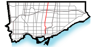
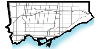
The Don Valley Parkway (DVP) is a municipal expressway in Toronto, Ontario, Canada, which connects the Gardiner Expressway in downtown Toronto with Highway 401. North of Highway 401, it continues as Highway 404. The parkway runs through the parklands of the Don River valley, after which it is named. It has a maximum speed limit of 90 km/h (56 mph) for its entire length of 15.0 km (9.3 mi). It is six lanes for most of its length, with eight lanes north of York Mills Road and four lanes south of Eastern Avenue. As a municipal road, it is patrolled by the Toronto Police Service.

Don Mills Neighbourhood in Toronto, Ontario, Canada

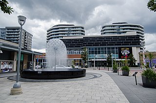
Don Mills is a mixed-use neighbourhood in the North York district of Toronto, Ontario, Canada. It was developed to be a self-supporting "new town" and was at the time located outside Toronto proper. In 1998, North York, including the Don Mills community, was amalgamated into Toronto proper. Consisting of residential, commercial and industrial sub-districts, it was planned and developed by private enterprise.

Rouge River (Ontario) River in Ontario, Canada

The Rouge River is a river in Markham, Pickering, Richmond Hill and Toronto in the Greater Toronto Area of Ontario, Canada. The river flows from the Oak Ridges Moraine to Lake Ontario at the eastern border of Toronto, and is the location of Rouge Park, the only national park in Canada within a municipality. At its southern end, the Rouge River is the boundary between Toronto and southwestern Pickering in the Regional Municipality of Durham.

Riverdale Park (Toronto)

Riverdale Park is a large park spanning the Lower Don River in Toronto, Ontario, Canada, between Cabbagetown to the west and Broadview Avenue in Riverdale to the east.

Cancelled expressways in Toronto Unbuilt freeways in Toronto, Canada

The cancelled expressways in Toronto were a planned series of expressways in Toronto, Ontario, Canada that were only partially built or cancelled due to public opposition. The system of expressways was intended to spur or handle growth in the suburbs of Toronto, but were opposed by citizens within the city of Toronto proper, citing the demolition of homes and park lands, air pollution, noise and the high cost of construction. The Spadina Expressway, planned since the 1940s, was cancelled in 1971 after being only partially constructed. After the Spadina cancellation, other expressway plans, intended to create a 'ring' around the central core, were abandoned.

Lawrence Avenue thoroughfare in Toronto, Ontario

Lawrence Avenue is a major east-west thoroughfare in Toronto, Ontario, Canada. It is divided into east and west portions by Yonge Street, the dividing line of east-west streets in Toronto.

Danforth Avenue Arterial street in Toronto

Danforth Avenue and Danforth Road are two historically-related arterial streets in Toronto, Ontario, Canada. Danforth Avenue is an east–west street that begins in Old Toronto at the Prince Edward Viaduct as a continuation of Bloor Street and continues for about 6 kilometres (3.7 mi) east through old Toronto, about 350 metres (1,150 ft) of old East York, and a further 5 kilometres (3.1 mi) in Scarborough until intersecting with Kingston Road via a ramped interchange. Danforth Road splits off the Avenue west of Warden Avenue, and runs diagonally northeast until south of Lawrence Avenue, where it continues as McCowan Road.

Bayview Avenue Major north-south route in the Greater Toronto Area of Ontario

Bayview Avenue is a major north–south route in the Greater Toronto Area of Ontario. North of Toronto, in York Region, Bayview is designated as York Regional Road 34.

Toronto and Region Conservation Authority(TRCA) is the largest of 36 conservation authorities in Ontario, Canada. It owns more than 16,000 hectares of land in the Toronto region and employs more than 400 full-time employees and coordinates more than 3,000 volunteers each year. TRCA's area of jurisdiction is watershed-based, and includes 3,467 square kilometres: 2,506 on land and 961 water-based in Lake Ontario. This area comprises nine watersheds from west to east: Etobicoke Creek, Mimico Creek, Humber River, Don River, Highland Creek, Petticoat Creek, Rouge River, Duffins Creek, Carruthers Creek.

Edwards Gardens

Edwards Gardens is a botanical garden located on the southwest corner of Leslie Street and Lawrence Avenue East in Toronto, Ontario, Canada. It is also the site of the Toronto Botanical Garden, a private not-for profit organization previously called the Civic Garden Centre.

Toronto Belt Line Railway

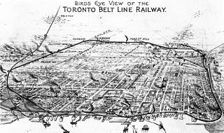
The Toronto Belt Line Railway was built during the 1890s in Toronto, Ontario, Canada. It consisted of two commuter railway lines to promote and service new suburban neighbourhoods outside of the then city limits. Both lines were laid as loops. The longer Don Loop ran north of the city limits, while the shorter Humber Loop ran west of the city limits. The railway was never profitable and it only ran for two years. Today, as part of a rails-to-trails project, the Beltline Trail lies on the right-of-way of the Don Loop.

Charles Sauriol

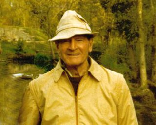
Charles Joseph Sauriol, was a Canadian naturalist who was responsible for the preservation of many natural areas in Ontario and across Canada. He owned property in the Don River valley and was an advocate for the valley's preservation. As a member of the Metropolitan Toronto and Region Conservation Authority, he was responsible for much of the Don Valley's conservation. A section of the valley is a conservation reserve named in his honour and four other locations in Canada are named in his honour.

Victoria Village Neighbourhood in Toronto, Ontario, Canada

Victoria Village, sometimes referred to as Sloane, is a neighbourhood in the city of Toronto, Ontario, Canada bounded on the west by the Don Valley, on the north by Lawrence Avenue East, on the east by Victoria Park Avenue, and on the south by Eglinton Avenue East, although there is a small area south of Eglinton to Sunrise Avenue that is sometimes included. It is located in the southeast of the former city of North York. Its population is diverse in ancestral backgrounds with a larger proportion of South Americans than most of the city.

King's Highway 11A, commonly referred to as Highway 11A, was the highway designation for an alternate route of Highway 11 in the Canadian province of Ontario. The north-south route paralleled Highway 11 within Toronto, serving as a secondary access to Downtown Toronto. It began at the York exit of the Gardiner Expressway (Highway 2) and travelled north on York Street to Front Street, where it transitioned onto University Avenue. It continued north on University Avenue to Queen's Park, where Highway 11A followed Queen's Park Crescent, encircling the Ontario Legislative Building, before continuing along Avenue Road. Highway 11A travelled along Avenue Road to Upper Canada College. It followed Lonsdale Road, Oriole Parkway, and Oxton Avenue around the campus and back to Avenue Road, which resumes north of the school. It continued north along Avenue Road to Highway 401, ending just north of the highway at Bombay Avenue.

Don Mills Trail

The Don Mills Trail is a 3-kilometre (1.9 mi) cycling and walking trail in Toronto, Ontario, Canada. The trail runs south from York Mills Road, east of and roughly parallel to Leslie Street. The city built the trail on the roadbed of a former railway line, known as the Leaside Spur.

References

Bibliography
Notes
  1. 1 2 Brown 1997, p. 166.
  2. 1 2 Brown 1997, p. 167.
  3. Bateman, Chris (February 23, 2013). "A brief history of skiing in the Don Valley". blogto.com.
  4. "Don Valley Ski Club". Ontario Abandoned Places. Retrieved February 26, 2013.
  5. City of Toronto (October 20, 2012). "Toronto celebrates the completion of the East Don Trail" (Press release). Retrieved May 28, 2019 via newswire.ca.