
A mountain is an elevated portion of the Earth's crust, generally with steep sides that show significant exposed bedrock. Although definitions vary, a mountain may differ from a plateau in having a limited summit area, and is usually higher than a hill, typically rising at least 300 metres (980 ft) above the surrounding land. A few mountains are isolated summits, but most occur in mountain ranges.

The Himalayas, or Himalaya, is a mountain range in Asia, separating the plains of the Indian subcontinent from the Tibetan Plateau. The range has some of the Earth's highest peaks, including the highest, Mount Everest; more than 100 peaks exceeding elevations of 7,200 m (23,600 ft) above sea level lie in the Himalayas.

Table Mountain is a flat-topped mountain forming a prominent landmark overlooking the city of Cape Town in South Africa. It is a significant tourist attraction, with many visitors using the cableway or hiking to the top. Table Mountain National Park is the most visited national park in South Africa, attracting 4.2 million people every year for various activities. The mountain has 8,200 plant species, of which around 80% are fynbos, meaning fine bush. It forms part of the Table Mountain National Park, and part of the lands formerly ranged by Khoe-speaking clans, such as the !Uriǁʼaes. It is home to a large array of mostly endemic fauna and flora.

Mount Hood is an active stratovolcano in the Cascade Volcanic Arc. It was formed by a subduction zone on the Pacific coast and rests in the Pacific Northwest region of the United States. It is located about 50 mi (80 km) east-southeast of Portland, on the border between Clackamas and Hood River counties. In addition to being Oregon's highest mountain, it is one of the loftiest mountains in the nation based on its prominence, and it offers the only year-round lift-served skiing in North America.

The Drakensberg is the eastern portion of the Great Escarpment, which encloses the central Southern African plateau. The Great Escarpment reaches its greatest elevation – 2,000 to 3,482 metres within the border region of South Africa and Lesotho.

Curtisia dentata is a flowering tree from Southern Africa. It is the sole species in genus Curtisia, which was originally classed as a type of "dogwood" (Cornaceae), but is now placed in its own unique family Curtisiaceae.

The honey badger, also known as the ratel, is a mammal widely distributed in Africa, Southwest Asia, and the Indian subcontinent. Because of its wide range and occurrence in a variety of habitats, it is listed as Least Concern on the IUCN Red List.

A mountain pass is a navigable route through a mountain range or over a ridge. Since mountain ranges can present formidable barriers to travel, passes have played a key role in trade, war, and both human and animal migration throughout history. At lower elevations it may be called a hill pass. A mountain pass is typically formed between two volcanic peaks or created by erosion from water or wind.
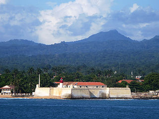
Pico de São Tomé is the highest mountain in São Tomé and Príncipe at 2,024 m (6,640 ft) elevation. It lies just west of the centre of São Tomé Island, in the Parque Natural Obô de São Tomé and in the Lembá District. The second highest point, Pico de Ana Chaves, lies about 3 km to its south east. The town Santa Catarina is 8 km to the west.

The Komati River, also known as the Inkomati River or Incomati River, is a river in South Africa, Eswatini and Mozambique. Originating in north-western Eswatini, it is joined by the Crocodile River in the Lebombo Mountains, enters far south-western Mozambique below the border town of Komatipoort, and enters the Indian Ocean around 24 km (15 mi) north-east of Maputo.

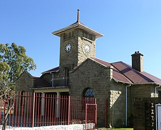
Barkly East is a town in Eastern Cape Province, South Africa, seat of the Joe Gqabi District Municipality, and 117 km by road E.S.E. of Aliwal North, lying in the mountainous area just south of Lesotho. The town lies at the southern tip of the Drakensberg on the Langkloofspruit, a tributary of the Kraai River which, in turn is a tributary of the Orange River at an elevation of 1 790 meter above sealevel. Barkly East is characterized by rugged mountains and green valleys. Snow falls in winter, and the hamlet of Rhodes is 60 km or an hour's drive from Barkly East on the R396. Both are within the boundaries of the Senqu Local Municipality.

Algoa Bay is a maritime bay in the Eastern Cape, South Africa. It is located in the east coast, 683 kilometres (424 mi) east of the Cape of Good Hope.

Coma Pedrosa is the highest mountain in the principality of Andorra. It is popular with mountain climbers, its ascent being technically straightforward, although strenuous. From Arinsal to Camp de Refuge is considered moderate meanwhile the last 862

The Great Escarpment is a major topographical feature in Africa that consists of steep slopes from the high central Southern African plateau downward in the direction of the oceans that surround southern Africa on three sides. While it lies predominantly within the borders of South Africa, in the east the escarpment extends northward to form the border between Mozambique and Zimbabwe, continuing on beyond the Zambezi river valley to form the Muchinga Escarpment in eastern Zambia. In the west, it extends northward into Namibia and Angola. It is the combination of this escarpment and the aridity of Southern Africa that leads to the lack of navigable rivers in South Africa.

Sir Henry Barkly was a British politician, colonial governor and patron of the sciences.

The Drakenstein mountain opposite Simonsberg Mountain named after ex military man and Colonial administrator of the Dutch East India Company Hendrik Adriaan van Rheede tot Drakenstein is part of the Cape Fold Belt and are in the Western Cape province of South Africa.

Eucalyptus oreades, commonly known as the Blue Mountains ash, white ash or smooth-barked mountain ash, is a species of medium-sized to tall tree that is native to eastern Australia. It has smooth, powdery whitish bark with rough bark near the base, lance-shaped to curved adult leaves, flower buds in groups of seven, white flowers and cup-shaped to cylindrical fruit.
Elliot, also known as Khowa, is a town in Chris Hani District Municipality in the Eastern Cape province of South Africa, and lies 80 km south-west of Maclear and 65 km south-east of Barkly East on the R56 road.
Guthalungra is a rural town and coastal locality in the Whitsunday Region, Queensland, Australia. In the 2016 census, the locality of Guthalungra had a population of 112 people.
Tradouws Pass is a pass through the Langeberg mountain range in South Africa. The R324, is the main road between Swellendam and Barrydale in the Western Cape.
