Related Research Articles
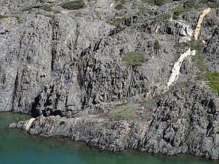
In geology, a shear zone is a thin zone within the Earth's crust or upper mantle that has been strongly deformed, due to the walls of rock on either side of the zone slipping past each other. In the upper crust, where rock is brittle, the shear zone takes the form of a fracture called a fault. In the lower crust and mantle, the extreme conditions of pressure and temperature make the rock ductile. That is, the rock is capable of slowly deforming without fracture, like hot metal being worked by a blacksmith. Here the shear zone is a wider zone, in which the ductile rock has slowly flowed to accommodate the relative motion of the rock walls on either side.

The Highland Boundary Fault is a major fault zone that traverses Scotland from Arran and Helensburgh on the west coast to Stonehaven in the east. It separates two different geological terranes which give rise to two distinct physiographic terrains: the Highlands and the Lowlands, and in most places it is recognisable as a change in topography. Where rivers cross the fault, they often pass through gorges, and the associated waterfalls can be a barrier to salmon migration.

In geology, shear is the response of a rock to deformation usually by compressive stress and forms particular textures. Shear can be homogeneous or non-homogeneous, and may be pure shear or simple shear. Study of geological shear is related to the study of structural geology, rock microstructure or rock texture and fault mechanics.

In geology, transpression is a type of strike-slip deformation that deviates from simple shear because of a simultaneous component of shortening perpendicular to the fault plane. This movement ends up resulting in oblique shear. It is generally very unlikely that a deforming body will experience "pure" shortening or "pure" strike-slip. The relative amounts of shortening and strike-slip can be expressed in the convergence angle alpha which ranges from zero to 90 degrees. During shortening, unless material is lost, transpression produces vertical thickening in the crust. Transpression that occurs on a regional scale along plate boundaries is characterized by oblique convergence. More locally, transpression occurs within restraining bends in strike-slip fault zones.

A fault trace describes the intersection of a geological fault with the Earth's surface, which leaves a visible disturbance on the surface, usually looking like a crack in the surface with jagged rock structures protruding outward. The term also applies to a line plotted on a geological map to represent a fault. These fractures tend to occur when a slip surface expands from a fault core, especially during an earthquake. This tends to occur with fault displacement, in which surfaces on both sides of a fault, known as fault blocks, separate horizontally or vertically.
The Neath Disturbance is a geological structure which stretches across south Wales from Swansea Bay northeastwards as far as Hereford in western England. It consists of a series of both faults and associated folds which were active during the mountain-building period known as the Variscan orogeny. This line of weakness probably featured in the earlier Caledonian Orogeny and perhaps reflects a more ancient line of weakness in the basement rocks.

The Olympic–Wallowa lineament (OWL) is a series of geologic structures oriented from northwest to southeast for 650 km (400 mi) across Washington and northeast Oregon in the United States, passing through the Seattle area and including notable features east of the Cascade Range such as the Yakima Fold Belt and Wallowa Mountains. It was first reported by cartographer Erwin Raisz in 1945 on a relief map of the continental United States. Some geologists have questioned the existence of a geological relationship between the individual structures along the lineament suggesting it is an optical illusion. The origin of this feature in its entirety is not well understood with multiple hypotheses on the subject. The Olympic–Wallowa lineament likely predates the Columbia River Basalt Group.
The Philippine fault system is a major inter-related system of geological faults throughout the whole of the Philippine Archipelago, primarily caused by tectonic forces compressing the Philippines into what geophysicists call the Philippine Mobile Belt. Some notable Philippine faults include the Guinayangan, Masbate and Leyte faults.

The Brothers Fault Zone (BFZ) is the most notable of a set of northwest-trending fault zones including the Eugene–Denio, McLoughlin, and Vale zones that dominate the geological structure of most of Oregon. These are also representative of a regional pattern of generally northwest-striking geological features ranging from Walker Lane on the California–Nevada border to the Olympic–Wallowa Lineament in Washington; these are generally associated with the regional extension and faulting of the Basin and Range Province, of which the BFZ is considered the northern boundary.

The Puget Sound faults under the heavily populated Puget Sound region of Washington state form a regional complex of interrelated seismogenic (earthquake-causing) geologic faults. These include the:

The Central African Shear Zone (CASZ) is a wrench fault system extending in an ENE direction from the Gulf of Guinea through Cameroon into Sudan. The structure is not well understood. As of 2008, there was still no general agreement about how the individual shears along the lineament link up.
The Trans Brazilian Lineament (TBL), or Transbrasiliano Lineament, is a major shear zone that developed in the Precambrian period, and that has been reactivated several times since then, mostly recently during the Mesozoic. Movement along the shear zone helps explain how the South American continent could have fitted tightly to the African continent before the breakup of Gondwana.
The Pharusian Ocean is an ancient ocean that existed on Earth from 800 to 635 million years ago, between the break-up of the Rodinia supercontinent and the start of formation of the Pannotia supercontinent.
The Kandi fault zone is a southern extension of the Hoggar fault zone in West Africa, with splays in Benin, Togo and southeastern Ghana. It lies at the southern end of the Trans Saharan belt, a lineament that extends in a southwest direction from Algeria to Benin. The Kandi fault zone is identified with the Sobral fault in northeastern Brazil, considered to be the northern section of the Trans Brazilian Lineament.
The Foumban Shear Zone, or Central Cameroon Shear Zone (CCSZ), is a fault zone in Cameroon that has been correlated with the Pernambuco fault in northeastern Brazil, which splays from the Trans-Brazilian Lineament. It is part of the Central African Shear Zone (CASZ) and dates to at least 640 million years ago. The zone was rejuvenated several times, usually with a dextral movement, before and during the opening of the South Atlantic in the Cretaceous period.
The Pernambuco Fault or Pernambuco Shear Zone in northeastern Brazil is a fault radiating from the Trans Brazilian Lineament eastwards to the coast, a major geological feature.
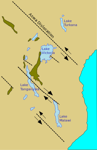
The Aswa Dislocation, also called the Aswa mylonite belt, Aswa Lineament or Aswa Shear Zone, is a north-west trending ductile shear zone that runs to the east of Lake Victoria in East Africa.
The Central Wales Lineament is a north–south aligned zone of geological faults and folds which runs for scores of miles through Wales and which gives rise to a number of landscape features. The lineament lies along the axis of the Central Wales Syncline, both following the generally northeast–southwest Caledonide trend though its central section is more north–south aligned.
The Romeral fault system is a megaregional system of major parallel and anastomosing faults in the Central Ranges of the Colombian Andes and the Cauca, Amagá, and Sinú-San Jacinto Basins. The system spans across ten departments of Colombia, from northeast to south Bolívar, Sucre, Córdoba, Antioquia, Caldas, Risaralda, Quindío, Valle del Cauca, Cauca and Nariño. The fault zone extends into Ecuador where it is known as the Peltetec fault system. The in detail described part of the Romeral fault system south of Córdoba has a total length of 697.4 kilometres (433.3 mi) with a cumulative length of 1,787.9 kilometres (1,110.9 mi) and runs along an average north to south strike of 017.6 ± 16, cross-cutting the central-western portion of Colombia.

Aerial photograph interpretation is a method of extrapolating geological details of the ground surface from aerial images. It allows geologists to analyze the distinguishing geological features and structures, plant cover, past history of the site, soil properties, and topography of the study area. It is crucial in the early stage of a geological mapping as it is less time-consuming and offers important data at a minimal price. It is also commonly used in other industries such as forest management, environmental science, disciplines of engineering, and investigating aviation accidents.
References
- ↑ Whitten & Brooks, The Penguin Dictionary of Geology 1972
- ↑ Attoh, K.; Brown, L. D. (2008). "The Neoproterozoic Trans-Saharan/Trans-Brasiliano shear zones: Suggested Tibetan Analogs". American Geophysical Union. 51. Bibcode:2008AGUSM.S51A..04A.
| | This tectonics article is a stub. You can help Wikipedia by expanding it. |