Tegua people

Last updated
Tegua
Total population
0 [1] (end 19th century)
Regions with significant populations
Boyacá, Casanare Flag of Colombia.svg  Colombia
Languages
Arawakan, Colombian Spanish
Religion
Traditional religion, Catholicism
Related ethnic groups
U'wa, Muisca, Achagua, Guayupe
Map of pre-Columbian civilizations. The Tegua lived east of the Muisca Culture precolombiennes en Colombie.png
Map of pre-Columbian civilizations. The Tegua lived east of the Muisca

The Tegua or Tecua were an Arawak-speaking [2] indigenous people of Colombia who died out in the 19th century. [1]

Contents

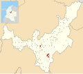
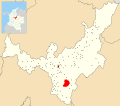
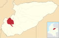
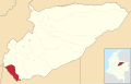
The territories of the Tegua stretched from Macanal, Boyacá in the west to Aguazul in the east and from Berbeo in the north to Villanueva in the south, on the eastern flanks of the Eastern Ranges of the Colombian Andes.

Knowledge of the Tegua is scarce, [3] but has been provided by pre-modern scholars Lucas Fernández de Piedrahita, Basilio Fernández de Oviedo and Pedro Simón and in modern times by Javier Ocampo López and Pedro Gustavo Huertas Ramírez. [3] [4]

Etymology

The name of the people Tegua, originally meaning "boy", [5] is presently a word in Colombian Spanish and means "shaman" or "witchdoctor", referring to the advanced knowledge the Tegua had of medicinal plants. [1] [3] [6]

Tegua territory

The Tegua inhabited the area of the lower and central Lengupá River valley in the Eastern Ranges of the Colombian Andes and the foothills (Piedemonte) towards the Llanos Orientales, such as the Casanare municipalities Recetor, Chámeza and Aguazul. [1] [7] [8] To the south, the Guayupe were living, the eastern part was bordering the territories of the Achagua and the western and northern terrains were inhabited by the Muisca. The Tegua living east of Guatavita paid tribute to the Muisca. [9] The origin of the Tegua people was in Campohermoso, Boyacá, where both the Lengupá and Upía Rivers flow. [10] [11]

Municipalities belonging to Tegua territories

Name Department Altitude (m)
urban centre
Map
Campohermoso Boyacá 1100
Colombia - Boyaca - Campohermoso.svg
Páez Boyacá 1300
Colombia - Boyaca - Paez.svg
Berbeo Boyacá 1335
Colombia - Boyaca - Berbeo.svg
Miraflores Boyacá 1432
Colombia - Boyaca - Miraflores.svg
Macanal
(shared with Muisca)
Boyacá 1680
Colombia - Boyaca - Macanal.svg
San Luis de Gaceno Boyacá 395
Colombia - Boyaca - San Luis de Gaceno.svg
Santa María Boyacá 850
Colombia - Boyaca - Santa Maria.svg
Aguazul
(shared with Achagua)
Casanare 290
Colombia - Casanare - Aguazul.svg
Recetor
(shared with Achagua)
Casanare 800
Colombia - Casanare - Recetor.svg
Chámeza
(shared with Achagua)
Casanare 1150
Colombia - Casanare - Chameza.svg
Sabanalarga Casanare 450
Colombia - Casanare - Sabanalarga.svg
Villanueva Casanare 420
Colombia - Casanare - Villanueva.svg

Description

De Piedrahita has written that the Tegua spoke another language and looked different from the Muisca. [3]

As noted by Pedro Simón, the Tegua had a diet formed by maize, honey, fish, coca and peanuts. [1] They cultivated yuca and made pies of yuca and ants. [12]

The chroniclers of the 17th century describe a Tegua woman with the assigned name La Cardeñosa, as a beautiful Tegua. [6] [11]

The first contact with the Tegua was made in 1538 by Juan de San Martín. [11] In 1556 the evangelization process was started to convert the Tegua to Catholicism. [11]

Names of Tegua caciques are reinstalled as street names of Campohermoso; Pirazica, Yayogua, Onayomba and Yapompo. [4] [10]

See also

Related Research Articles

<span class="mw-page-title-main">Muisca</span> Ethnic group, Colombia

The Muisca are an indigenous people and culture of the Altiplano Cundiboyacense, Colombia, that formed the Muisca Confederation before the Spanish conquest. The people spoke Muysccubun, a language of the Chibchan language family, also called Muysca and Mosca. They were encountered by conquistadors dispatched by the Spanish Empire in 1537 at the time of the conquest. Subgroupings of the Muisca were mostly identified by their allegiances to three great rulers: the hoa, centered in Hunza, ruling a territory roughly covering modern southern and northeastern Boyacá and southern Santander; the psihipqua, centered in Muyquytá and encompassing most of modern Cundinamarca, the western Llanos; and the iraca, religious ruler of Suamox and modern northeastern Boyacá and southwestern Santander.

<span class="mw-page-title-main">Sutagao people</span>

The Sutagao are the Chibcha-speaking indigenous people from the region of Fusagasugá, Bogotá savanna, Cundinamarca, Colombia. Knowledge about the Sutagao has been provided by scholar Lucas Fernández de Piedrahita.

<span class="mw-page-title-main">Muzo</span> Municipality and town in Boyacá Department, Colombia

Muzo is a town and municipality in the Western Boyacá Province, part of the department of Boyacá, Colombia. It is widely known as the world capital of emeralds for the mines containing the world's highest quality gems of this type. Muzo is situated at a distance of 178 kilometres (111 mi) from the departmental capital Tunja and 118 kilometres (73 mi) from the capital of the Western Boyacá Province, Chiquinquirá. The urban centre is at an altitude of 815 metres (2,674 ft) above sea level. Muzo borders Otanche and San Pablo de Borbur in the north, Maripí and Coper in the east, Quípama in the west and the department of Cundinamarca in the south.

<span class="mw-page-title-main">Pisba</span> Municipality and town in Boyacá Department, Colombia

Pisba is a town and municipality in Boyacá Department, Colombia, part of the subregion of La Libertad Province. Pisba is situated in the Eastern Ranges of the Colombian Andes at altitudes between 2,400 metres (7,900 ft) and 3,500 metres (11,500 ft). Distance to Sogamoso is 128 kilometres (80 mi) and to Tunja 176 kilometres (109 mi). The municipality borders Paya in the east, Labranzagrande in the south and Mongua in the northwest. The Casanare municipality Támara borders Pisba in the north.

<span class="mw-page-title-main">Lache people</span> Pre-Hispanic ethnic group of present-day Colombia

The Lache were an indigenous, agrarian people in the highlands of what is now central Colombia's northern Boyacá and Santander departments, primarily in Gutiérrez Province and García Rovira Province. They were part of the Cocuy Confederation and spoke Chibcha, trading predominantly with other Chibcha speakers, such as the Muisca, Guane, Pijao and Chitarero. Trade included salt and textiles, as well as food stuffs. The Lache farmed maize, potatoes, quinoa and cotton, among other crops.

<span class="mw-page-title-main">Spanish conquest of the Chibchan nations</span> Part of the Spanish conquest of Colombia

The Spanish conquest of the Chibchan nations refers to the conquest by the Spanish monarchy of the Chibcha language-speaking nations, mainly the Muisca and Tairona that inhabited present-day Colombia, beginning the Spanish colonization of the Americas.

<span class="mw-page-title-main">Muisca Confederation</span> Former Andean highlands confederation

The Muisca Confederation was a loose confederation of different Muisca rulers in the central Andean highlands of what is today Colombia before the Spanish conquest of northern South America. The area, presently called Altiplano Cundiboyacense, comprised the current departments of Boyacá, Cundinamarca and minor parts of Santander.

<span class="mw-page-title-main">Huitaca (goddess)</span> Goddess in Muisca religion of South America

Huitaca or Xubchasgagua was a rebelling goddess in the religion of the Muisca. The Muisca and their confederation were a civilization who inhabited the Altiplano Cundiboyacense in the Andes. Huitaca has been described by the chroniclers Juan de Castellanos in his Elegías de varones ilustres de Indias, Lucas Fernández de Piedrahita and Pedro Simón.

<span class="mw-page-title-main">Muisca religion</span> Indigenous religion of Colombia

Muisca religion describes the religion of the Muisca who inhabited the central highlands of the Colombian Andes before the Spanish conquest of the Muisca. The Muisca formed a confederation of holy rulers and had a variety of deities, temples and rituals incorporated in their culture. Supreme being of the Muisca was Chiminigagua who created light and the Earth. He was not directly honoured, yet that was done through Chía, goddess of the Moon, and her husband Sué, god of the Sun. The representation of the two main celestial bodies as husband and wife showed the complementary character of man and woman and the sacred status of marriage.

<span class="mw-page-title-main">Pedro Simón</span> Spanish franciscan friar, professor and chronicler

Fray Pedro Simón was a Spanish franciscan friar, professor and chronicler of the indigenous peoples of modern day Colombia and Venezuela, at the time forming the New Kingdom of Granada. Pedro Simón is one of the most important Muisca scholars forming the basis for later scholars such as Lucas Fernández de Piedrahita, Alexander von Humboldt, Javier Ocampo López and many others.

<span class="mw-page-title-main">Tundama</span> Tribal leader

Tundama or Saymoso was a cacique of the Muisca Confederation, a loose confederation of different rulers of the Muisca who inhabited the central highlands of the Colombian Andes. The city of Tundama, currently known as Duitama and part of the Tundama Province, Boyacá, were named after the cacique. Tundama ruled over the northernmost territories of the Muisca, submitted last by the Spanish conquistadores.

<span class="mw-page-title-main">Guayupe</span> Indigenous group in modern-day Colombia

The Guayupe are an Arawak-speaking indigenous group of people in modern-day Colombia. They inhabit the westernmost parts of the department of Meta. At the time of the Spanish conquest, more than 250,000 Guayupe were living in large parts of Meta.

<span class="mw-page-title-main">Women in Muisca society</span>

This article describes the role of women in the society of the Muisca. The Muisca are the original inhabitants of the Altiplano Cundiboyacense before the Spanish conquest of the Muisca in the first half of the 16th century. Their society was one of the four great civilizations of the Americas.

<span class="mw-page-title-main">Muzo people</span>

The Muzo people were a Cariban-speaking indigenous group who inhabited the western slopes of the eastern Colombian Andes. They were a highly war-like tribe who frequently clashed with their neighbouring indigenous groups, especially the Muisca.

<span class="mw-page-title-main">Muisca economy</span>

This article describes the economy of the Muisca. The Muisca were the original inhabitants of the Altiplano Cundiboyacense, the high plateau in the Eastern Ranges of central present-day Colombia. Their rich economy and advanced merchant abilities were widely known by the indigenous groups of the area and described by the Spanish conquistadores whose primary objective was the acquisition of the mineral resources of Tierra Firme; gold, emeralds, carbon, silver and copper.

<span class="mw-page-title-main">Goranchacha Temple</span>

The Goranchacha Temple is an archeological site of the Muisca located in the city of Tunja, Boyacá, which in the time of the Muisca Confederation was called Hunza. The temple is named after the mythological Goranchacha. The remains of the temple are located on the terrain of the Pedagogical and Technological University of Colombia in Tunja. Scholar Javier Ocampo López has written about the temple and its religious meaning. Knowledge about the temple has been provided by chronicler Pedro Simón.

<span class="mw-page-title-main">Tenza Valley</span>

The Tenza Valley is an intermontane valley in the Eastern Ranges of the Colombian Andes. The valley stretches over the southeastern part of the department of Boyacá and the northeastern part of Cundinamarca. It is located east of the Altiplano Cundiboyacense and in the time before the Spanish conquest of the Muisca, as the Altiplano was inhabited by the Muisca in the higher altitudes and the Tegua in the lower areas to the east.

<span class="mw-page-title-main">Muisca warfare</span>

This article describes the warfare of the Muisca. The Muisca inhabited the Tenza and Ubaque valleys and the Altiplano Cundiboyacense, the high plateau of the Colombian Eastern Ranges of the Andes in the time before the Spanish conquest. Their society was mainly egalitarian with little difference between the elite class (caciques) and the general people. The Muisca economy was based on agriculture and trading raw materials like cotton, coca, feathers, sea snails and gold with their neighbours. Called "Salt People", they extracted salt from brines in Zipaquirá, Nemocón and Tausa to use for their cuisine and as trading material.

<span class="mw-page-title-main">Battle of Tocarema</span>

The Battle of Tocarema was a battle fought between an alliance of the troops of Spanish conquistador Gonzalo Jiménez de Quesada and zipa of the Muisca Sagipa of the southern Muisca Confederation and the indigenous Panche. The battle took place on the afternoon of August 19 and the morning of August 20, 1538 in the vereda Tocarema of Cachipay, Cundinamarca, Colombia and resulted in a victory for the Spanish and Muisca, when captains Juan de Céspedes and Juan de Sanct Martín commanded two flanks of the conquistadors.

References

  1. 1 2 3 4 5 (in Spanish) Historia de los Teguas
  2. (in Spanish) Official website Miraflores
  3. 1 2 3 4 (in Spanish) Las esmeraldas de Colombia
  4. 1 2 (in Spanish) Los Teguas - El Tiempo
  5. (in Spanish) Curanderos, contras y culebras
  6. 1 2 (in Spanish) Tesoros legendarios
  7. (in Spanish) Inspección Arqueológica en Territorio Tegua
  8. (in Spanish) Los pueblos indígenas del territorio Colombiano
  9. (in Spanish) Los señores Chibchas - Universidad Distrital Francisco José de Caldas
  10. 1 2 (in Spanish) Campohermoso rescata su memoria histórica - El Tiempo
  11. 1 2 3 4 (in Spanish) Historia de Campohermoso
  12. (in Spanish) La yuca, alimento prehispánico