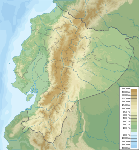
Nevado del Ruiz, also known as La Mesa de Herveo is a volcano on the border of the departments of Caldas and Tolima in Colombia, about 129 km (80 mi) west of the capital city Bogotá. It is a stratovolcano composed of many layers of lava alternating with hardened volcanic ash and other pyroclastic rocks. Volcanic activity at Nevado del Ruiz began about two million years ago, during the Early Pleistocene or Late Pliocene, with three major eruptive periods. The current volcanic cone formed during the present eruptive period, which began 150,000 years ago.
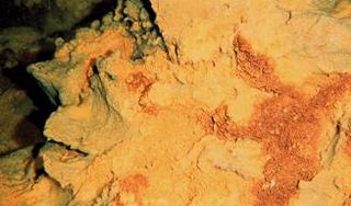
Kamaʻehuakanaloa Seamount is an active submarine volcano about 22 mi (35 km) off the southeast coast of the island of Hawaii. The top of the seamount is about 3,200 ft (975 m) below sea level. This seamount is on the flank of Mauna Loa, the largest active subaerial shield volcano on Earth. Kamaʻehuakanaloa is the newest volcano in the Hawaiian–Emperor seamount chain, a string of volcanoes that stretches about 3,900 mi (6,200 km) northwest of Kamaʻehuakanaloa. Unlike most active volcanoes in the Pacific Ocean that make up the active plate margins on the Pacific Ring of Fire, Kamaʻehuakanaloa and the other volcanoes of the Hawaiian–Emperor seamount chain are hotspot volcanoes and formed well away from the nearest plate boundary. Volcanoes in the Hawaiian Islands arise from the Hawaii hotspot, and as the youngest volcano in the chain, Kamaʻehuakanaloa is the only Hawaiian volcano in the deep submarine preshield stage of development.
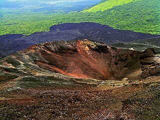
Cerro Negro is an active volcano in the Cordillera de los Maribios mountain range in Nicaragua, about 10 km (6.2 mi) from the village of Malpaisillo. It is a very new volcano, the youngest in Central America, having first appeared in April 1850. It consists of a gravelly basaltic cinder cone, which contrasts greatly with the surrounding verdant hillsides, and gives rise to its name, which means Black Hill. Cerro Negro has erupted frequently since its first eruption. One unusual aspect of several eruptions has been the emission of ash from the top of the cone, while lava erupts from fractures at the base.

Cerro Azul, sometimes referred to as Quizapu, is an active stratovolcano in the Maule Region of central Chile, immediately south of Descabezado Grande. Part of the South Volcanic Zone of the Andes, its summit is 3,788 meters (12,428 ft) above sea level, and is capped by a summit crater that is 500 meters (1,600 ft) wide and opens to the north. Beneath the summit, the volcano features numerous scoria cones and flank vents.

Babuyan Claro Volcano, also known as Mount Pangasun, is an active volcano located on Babuyan Island, the northernmost of the Babuyan group of islands in Luzon Strait, north of the main island of Luzon in the Philippines. It is classified as one of the active volcanoes of the country with the last confirmed eruption in 1860.

Tacora is a stratovolcano located in the Andes of the Arica y Parinacota Region of Chile. Near the border with Peru, it is one of the northernmost volcanoes of Chile. It is part of the Central Volcanic Zone in Chile, one of the four volcanic belts of the Andes. The Central Volcanic Zone has several of the highest volcanoes in the world. Tacora itself is a stratovolcano with a caldera and a crater. The youngest radiometric age is 50,000 years ago and it is heavily eroded by glacial activity.
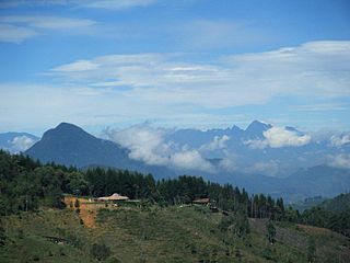
Cerro Bravo is a stratovolcano located in Tolima, Colombia, north of the Nevado del Ruiz volcano. The rock type of the volcano is andesite.

Puracé is an andesitic stratovolcano located in the Puracé National Natural Park in the Cauca Department, Colombia. It is part of the North Volcanic Zone of the Andean Volcanic Belt. The volcano is located at the intersection of the Coconucos and Morras Faults.

Cumbal is a stratovolcano of the Caribe Terrane, located at the Nudo de los Pastos in Nariño, Colombia. It is the southernmost historically active volcano of Colombia and is together with Chiles and Azufral one of the few volcanoes of the Western Ranges. The volcano is dominated by andesites.
Cerro Negro de Mayasquer is a volcano on the border of Colombia and Ecuador. It lies 3 kilometres (2 mi) north-west of the volcano Chiles, and the two peaks are considered part of the same Chiles-Cerro Negro volcanic complex. These volcanoes, together with Cumbal are andesitic in rock type. A 1936 eruption reported by the Colombian government agency INGEOMINAS may have been from the Ecuadorean volcano Reventador, otherwise the volcano has not erupted for around 160,000 years.

Sotará is a stratovolcano located in Sotará, Cauca, Colombia. The volcano has hot springs of 80 °C (176 °F) and fumarole activity with a composition of 80% CO2 and 20% H2S. The volcano is located between the Silvia-Pijao Fault in the west and the San Jerónimo Fault in the east.
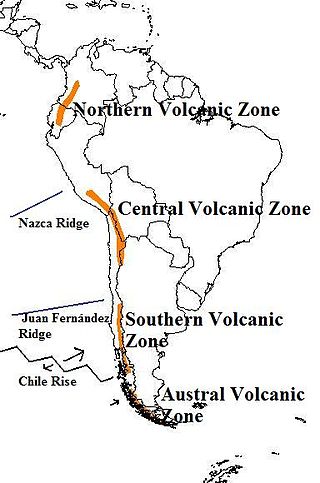
The Andean Volcanic Belt is a major volcanic belt along the Andean cordillera in Argentina, Bolivia, Chile, Colombia, Ecuador, and Peru. It is formed as a result of subduction of the Nazca Plate and Antarctic Plate underneath the South American Plate. The belt is subdivided into four main volcanic zones which are separated by volcanic gaps. The volcanoes of the belt are diverse in terms of activity style, products, and morphology. While some differences can be explained by which volcanic zone a volcano belongs to, there are significant differences within volcanic zones and even between neighboring volcanoes. Despite being a type location for calc-alkalic and subduction volcanism, the Andean Volcanic Belt has a broad range of volcano-tectonic settings, as it has rift systems and extensional zones, transpressional faults, subduction of mid-ocean ridges and seamount chains as well as a large range of crustal thicknesses and magma ascent paths and different amounts of crustal assimilations.

Volcán Putana, sometimes referred to as Jorqencal or Machuca, is a stratovolcano located In the Central Volcanic Zone (CVZ) of the Andes on the border between Bolivia and Chile and close to the Sairecabur volcanic complex. Its summit is 5,884 metres (19,304 ft) above sea level and contains a summit crater with two smaller craters nested within it. Beneath the summit, the volcano features a number of lava domes and lava flows, some of which originated in flank vents.
The Nevado El Cisne is a volcano in the Central Ranges of the Andes in Colombia. Its summit is at an altitude of 4,636 metres (15,210 ft). The mountain is one of the five lava domes of the Nevado del Ruiz volcano complex. Despite the nevado part of the name, indicating a permanently snow-capped mountain, the summit of El Cisne is now below the permanent snow line as a result of global warming, and it is no longer considered a true nevado. The volcano is located over the Palestina Fault, that crosscuts the underlying El Bosque Batholith of Eocene age, dated at 49.1 ± 1.7 Ma.

Olca-Paruma is a volcanic complex in Chile. Lying on the border between Chile and Bolivia, it is formed by an east–west alignment of volcanoes. From west to east, these are Cerro Paruma, Volcan Paruma, Olca, and Mencheca or Michincha. Aside from the mines of Ujina, Rosario, and Quebrada Blanca, the area is sparsely populated.
The Romeral Fault System is a megaregional system of major parallel and anastomosing faults in the Central Ranges of the Colombian Andes and the Cauca, Amagá, and Sinú-San Jacinto Basins. The system spans across ten departments of Colombia, from northeast to south Bolívar, Sucre, Córdoba, Antioquia, Caldas, Risaralda, Quindío, Valle del Cauca, Cauca and Nariño. The fault zone extends into Ecuador where it is known as the Peltetec Fault System. The in detail described part of the Romeral Fault System south of Córdoba has a total length of 697.4 kilometres (433.3 mi) with a cumulative length of 1,787.9 kilometres (1,110.9 mi) and runs along an average north to south strike of 017.6 ± 16, cross-cutting the central-western portion of Colombia.
The Palestina Fault is a regional sinistral oblique thrust fault in the departments of Antioquia, Caldas and Bolívar in central Colombia. The fault has a total length of 369.6 kilometres (229.7 mi) and runs along an average north-northeast to south-southwest strike of 017.8 ± 11 along the Central Ranges of the Colombian Andes.

The Colombian Geological Survey (CGS) is a scientific agency of the Colombian government in charge of contributing to the socioeconomic development of the nation through research in basic and applied geosciences of the subsoil, the potential of its resources, evaluating and monitoring threats of geological origin, managing the geoscientific knowledge of the nation, and studying the nuclear and radioactive elements in Colombia.
Cerro Tuzgle is a dormant stratovolcano in the Susques Department of Jujuy Province in northwestern Argentina. Tuzgle is a prominent volcano of the back arc of the Andes and lies about 280 kilometres (170 mi) east of the main volcanic arc. Part of the Central Volcanic Zone of the Andes, its summit is 5,486 metres (17,999 ft) above sea level and it grew during different stages over a caldera and lava domes. Some major lava flows emanate from the summit crater, and one confirmed and one possible flank collapse unit as well as an ignimbrite sheet are associated with Tuzgle.

Guallatiri is a volcano in Chile with an elevation of 6,060 to 6,071 m. It is located southwest of the Nevados de Quimsachata volcanic group; some sources classify Guallatiri as a member. Guallatiri is a stratovolcano with numerous fumaroles around the summit. The summit may be a lava dome or volcanic plug, while the lower flanks of the volcano are covered by lava flows and lava domes. The volcano's eruptions have produced mostly dacite along with andesite and rhyolite. Past glaciation has left moraines on Guallatiri.

