Romeral (volcano)

Last updated
Romeral
Volcán Romeral
Volcan Romeral.jpg
Romeral
Highest point
Elevation 3,858 m (12,657 ft)
Listing Volcanoes of Colombia
Coordinates 5°12′22″N75°21′50″W / 5.20611°N 75.36389°W / 5.20611; -75.36389
Geography
Colombia relief location map.jpg
Red triangle with thick white border.svg
Romeral
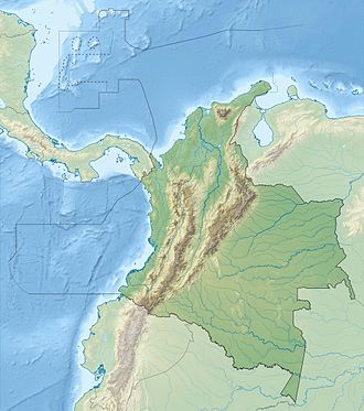
Location of Romeral in Colombia
Location Caldas
Flag of Colombia.svg  Colombia
Parent range Central Ranges, Andes
Geology
Age of rock Pliocene-Holocene
Mountain type Andesitic-dacitic stratovolcano
Last eruption 5390 BCE ± 500 years

Romeral is a stratovolcano located in Caldas, Colombia. It is the northernmost Holocene volcano of South America, of the North Volcanic Zone in the Andean Volcanic Belt. The volcano was formed in the Late Pliocene, approximately 3 million years ago. [1]
Contents

See also

Related Research Articles

<span class="mw-page-title-main">Nevado del Ruiz</span> Volcanic mountain in Colombia

Nevado del Ruiz, also known as La Mesa de Herveo is a volcano on the border of the departments of Caldas and Tolima in Colombia, being the highest point of both. It is located about 130 km (81 mi) west of the capital city Bogotá. It is a stratovolcano composed of many layers of lava alternating with hardened volcanic ash and other pyroclastic rocks. Volcanic activity at Nevado del Ruiz began about two million years ago, during the Early Pleistocene or Late Pliocene, with three major eruptive periods. The current volcanic cone formed during the present eruptive period, which began 150,000 years ago.

<span class="mw-page-title-main">Galeras</span> Volcanic mountain in Colombia

Galeras is an Andean stratovolcano in the Colombian department of Nariño, near the departmental capital Pasto. Its summit rises 4,276 metres (14,029 ft) above sea level. It has erupted frequently since the Spanish conquest, with its first historical eruption being recorded on December 7, 1580. A 1993 eruption killed nine people, including six scientists who had descended into the volcano's crater to sample gases and take gravity measurements in an attempt to be able to predict future eruptions. It is currently the most active volcano in Colombia.

<span class="mw-page-title-main">Armero tragedy</span> November 1985 volcanic eruption in Colombia

The Armero tragedy occurred following the eruption of the Nevado del Ruiz stratovolcano in Tolima, Colombia, on November 13, 1985. The volcano's eruption after 69 years of dormancy caught nearby towns unprepared, even though volcanological organizations had warned the government to evacuate the area after they detected volcanic activity two months earlier.

<span class="mw-page-title-main">Omayra Sánchez</span> Colombian volcano victim (1972–1985)

Omayra Sánchez Garzón was a Colombian girl trapped and killed by a landslide when she was 13 years old.

<span class="mw-page-title-main">Puracé</span> Volcanic mountain in Colombia

Puracé is an andesitic stratovolcano located in the Puracé National Natural Park in the Cauca Department, Colombia. It is part of the North Volcanic Zone of the Andean Volcanic Belt. The volcano is located at the intersection of the Coconucos and Morras Faults.

<span class="mw-page-title-main">Andean Volcanic Belt</span> Volcanic belt in South America

The Andean Volcanic Belt is a major volcanic belt along the Andean cordillera in Argentina, Bolivia, Chile, Colombia, Ecuador, and Peru. It is formed as a result of subduction of the Nazca Plate and Antarctic Plate underneath the South American Plate. The belt is subdivided into four main volcanic zones which are separated by volcanic gaps. The volcanoes of the belt are diverse in terms of activity style, products, and morphology. While some differences can be explained by which volcanic zone a volcano belongs to, there are significant differences within volcanic zones and even between neighboring volcanoes. Despite being a type location for calc-alkalic and subduction volcanism, the Andean Volcanic Belt has a broad range of volcano-tectonic settings, as it has rift systems and extensional zones, transpressional faults, subduction of mid-ocean ridges and seamount chains as well as a large range of crustal thicknesses and magma ascent paths and different amounts of crustal assimilations.

Las Ánimas is a volcano of the Central Ranges of the Colombian Andes at the border of the departments of Cauca and Nariño. The volcano is 4,175 metres (13,698 ft) high.

The Romeral Fault System is a megaregional system of major parallel and anastomosing faults in the Central Ranges of the Colombian Andes and the Cauca, Amagá, and Sinú-San Jacinto Basins. The system spans across ten departments of Colombia, from northeast to south Bolívar, Sucre, Córdoba, Antioquia, Caldas, Risaralda, Quindío, Valle del Cauca, Cauca and Nariño. The fault zone extends into Ecuador where it is known as the Peltetec Fault System. The in detail described part of the Romeral Fault System south of Córdoba has a total length of 697.4 kilometres (433.3 mi) with a cumulative length of 1,787.9 kilometres (1,110.9 mi) and runs along an average north to south strike of 017.6 ± 16, cross-cutting the central-western portion of Colombia.

The Montenegro Fault is an oblique sinistral strike-slip fault in the department of Quindío in west-central Colombia. The fault is part of the megaregional Romeral Fault System and has a total length of 21.7 kilometres (13.5 mi) and runs along an average northwest to southeast strike of 025.1 ± 9 in the Central Ranges of the Colombian Andes.

The Armenia Fault is an oblique sinistral strike-slip fault in the department of Quindío in west-central Colombia. The fault is part of the megaregional Romeral Fault System and has a total length of approximately 32 kilometres (20 mi) and runs along an average northwest to southeast strike of 023.2 ± 11 in the Central Ranges of the Colombian Andes. The fault shows Holocene activity with a surface rupture produced in 2001.

The Piendamó Fault is an oblique dextral strike-slip fault in the department of Cauca in southwestern Colombia. The fault is part of the megaregional Romeral Fault System and has a total length of 28.3 kilometres (17.6 mi) and runs along a variable average north to south strike of 341.6 ± 18 in the Central Ranges of the Colombian Andes.

The Guáitara Fault is a dextral strike-slip fault in the department of Nariño in southwestern Colombia. The fault has a total length of 36.1 kilometres (22.4 mi) and runs along an average northeast to the southwest strike of 044.1 ± 4 in the Western Ranges of the Colombian Andes.

The Irlanda Fault is a dextral strike-slip fault in the department of Cauca in south-central Colombia. A small portion of the fault runs through Huila. The fault has a total length of 54.6 kilometres (33.9 mi) and runs along an average northeast to southwest strike of 023 ± 4 in the Central Ranges of the Colombian Andes. The fault is active and associated with the deadly 1994 Páez River earthquake.

The La Plata or Chusma Fault is a dextral oblique thrust fault in the department of Huila in southwestern Colombia. The fault has a total length of 113.2 kilometres (70.3 mi) and runs along an average northeast to southwest strike of 039 ± 12 in the Central Ranges of the Colombian Andes.

The Palestina Fault is a regional sinistral oblique thrust fault in the departments of Antioquia, Caldas and Bolívar in central Colombia. The fault has a total length of 369.6 kilometres (229.7 mi) and runs along an average north-northeast to south-southwest strike of 017.8 ± 11 along the Central Ranges of the Colombian Andes.

The Santa Rita Fault is a strike-slip fault in the department of Antioquia in northern Colombia. The fault has a total length of 81.0 kilometres (50.3 mi) and runs along an average north to south strike of 010.6 ± 6 in the Central Ranges of the Colombian Andes.

<span class="mw-page-title-main">Paipa-Iza volcanic complex</span>

The Paipa–Iza volcanic complex is a volcanic field of Late Pliocene to Early Pleistocene age on the Altiplano Cundiboyacense in the Eastern Ranges of the Colombian Andes. It is the northernmost volcanic complex of the Andean Volcanic Belt with Fueguino in Tierra del Fuego, Chile, at the opposite end of the Andean mountain belt.

<span class="mw-page-title-main">Caribbean Terrane</span> Geological province of Colombia

The Caribbean Terrane is a geological province (terrane) of Colombia. The terrane, dating to the Late Cretaceous, is situated on the North Andes Plate and borders the La Guajira, Chibcha and underlying Tahamí Terrane along the regional Bucaramanga-Santa Marta Fault. The terrane overlies the Tahamí, Arquía and Quebradagrande Terranes along the Romeral Fault System.

<span class="mw-page-title-main">Chibcha Terrane</span>

The Chibcha Terrane, named after Chibcha, is the largest of the geological provinces (terranes) of Colombia. The terrane, the oldest explored domains of which date to the Meso- to Neoproterozoic, is situated on the North Andes Plate. The megaregional Romeral Fault System forms the contact of the terrane with the Tahamí Terrane. The contact with the Caribbean and La Guajira Terranes is formed by the regional Bucaramanga-Santa Marta Fault. The northeastern boundary is formed by the regional Oca Fault, bounding the La Guajira Terrane. The terrane is emplaced over the Río Negro-Juruena Province of the Amazonian Craton along the megaregional Eastern Frontal Fault System.

<span class="mw-page-title-main">Tahamí Terrane</span>

The Tahamí or Tahamí-Panzenú Terrane is one of the geological provinces (terranes) of Colombia. The terrane, dating to the Permo-Triassic, is situated on the North Andes Plate. The contact with the Chibcha, Arquía and Quebradagrande Terranes is formed by the megaregional Romeral Fault System. A tiny terrane is located at the contact with the Quebradagrande Terrane; Anacona Terrane.

References

  1. Bohórquez et al., 2005, p.72

Bibliography