
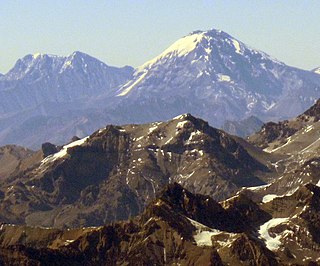
Nevado Ojos del Salado is a dormant complex volcano in the Andes on the Argentina–Chile border. It is the highest volcano on Earth and the highest peak in Chile. The upper reaches of Ojos del Salado consist of several overlapping lava domes, lava flows and volcanic craters, with sparse ice cover. The complex extends over an area of 70–160 square kilometres (27–62 sq mi) and its highest summit reaches an altitude of 6,893 metres (22,615 ft) above sea level. Numerous other volcanoes rise around Ojos del Salado.

Cerro Walther Penck is a massive complex volcano in the Andes, located in northwestern Argentina, Catamarca Province, Tinogasta Department, at the Puna de Atacama. It is just southwest of Ojos del Salado, the highest volcano in the world. Walther Penck itself is perhaps the third highest active volcano in the world.

Incahuasi is a volcanic mountain in the Andes of South America. It lies on the border of the Catamarca Province of Argentina and the Atacama Region of Chile. Incahuasi has a summit elevation of 6,621 metres (21,722 ft) above sea level.

Cerro Solo is a large stratovolcano on the border between Argentina and Chile, west of Ojos del Salado with an elevation of 6,215 metres (20,390 ft) metres. It consists of nine eruptive centers and is covered in light-colored rhyodacite pyroclastic flow deposits.
Nevado Juncal is a mountain at the border of Argentina and Chile, at the head of Aconcagua Val. It has a height of 5,953 metres (19,531 ft). It is located at La Yesera, Los Andes Department, Valparaíso Region, at the Central Andes. The mountain hosts several glaciers including the Juncal Norte and Juncal Sur.
Ramada is a group or massif in Argentina. It has a height of 6,384 metres (20,945 ft). It's located at Calingasta Department, San Juan Province, at the Cordillera de la Ramada.
Nevado Queva or Quewar is a volcano in the Andes mountain range of South America, located in the Salta Province of Argentina. Queva has a summit elevation of 6,140 metres (20,144 ft) above sea level. Its name is alternately spelled Quehuar. There are extensive pre-Columbian ruins on the summit of the mountain, which is a broad crater.
Cerro Vicuñas is a volcanic mountain in the Andes of Chile which lies immediately north of Ojos del Salado. It has a height of 6067 metres. Vicuñas if often used as acclimatisation peak before major peaks like Ojos del Salado. Its slopes are within the administrative boundaries of the Chilean commune of Copiapo.

Palpana is a volcano in the Andes of Chile. It has a summit elevation of 6,040 metres (19,820 ft).

Hualca Hualca is an extinct volcano in Arequipa Region in the Andes of Peru. It has a height of 6,025 metres (19,767 ft). It is located at the Peruvian province of Caylloma.

Barrancas Blancas is a peak in Chile with an elevation of 6,119 metres (20,075 ft) metres. Barrancas Blancas is within the following mountain ranges: Chilean Andes and Puna de Atacama. It is located within the territory of the Chilean province of Copiapo. Its slopes are within the administrative boundaries of the Chilean commune of Copiapo.

Cerro Capurata, also known as Elena Capurata or Quimsachatas is a stratovolcano in the Andes of Bolivia and Chile. To the south of Capurata lies Cerro Casparata and straight west Guallatiri, which shares a near-identical elevation with Capurata.

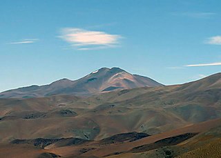
Acamarachi is a 6,046-metre (19,836 ft) high volcano in northern Chile. In this part of Chile, it is the highest volcano. Its name means "black moon". It is a volcano in the Central Volcanic Zone of the Andes, a zone of strong volcanic activity during the last million years. Old volcanoes in the area are well-preserved, due to the dry climate.

Nevado El Fraile also called Incahuasi Chico is a volcanic mountain in the Andes of Chile. It sits at the border of Argentina and Chile. Along with numerous other volcanic peaks in the region, including Ojos del Salado, the highest volcano in the world, it is part of the Central Volcanic Zone. The closest higher peak is Incahuasi, which is 7.9 kilometres (4.9 mi) to the east.
Ameghino is a mountain in Argentina. It has a height of 5,950 metres (19,521 ft).
Medusa is a mountain at the border of Argentina and Chile. It has a height of 6,130 metres (20,112 ft). It's located at Catamarca Province, Tinogasta Department, at the Puna de Atacama. At the Chilean side, its shares territories with the commune of Copiapó.

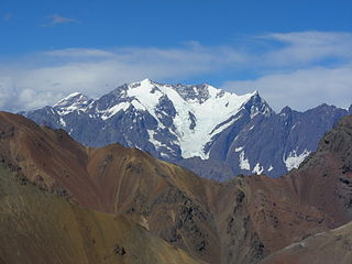
Nevado Tres Cruces is a massif of volcanic origin in the Andes Mountains on the border of Argentina and Chile. It has two main summits, Tres Cruces Sur at 6,748 metres (22,139 ft) and Tres Cruces Centro at 6,629 m (21,749 ft) and a third minor summit, Tres Cruces Norte 6,030 m (19,780 ft). Tres Cruces Sur is the sixth highest mountain in the Andes.
Nacimientos del Jague is a mountain in Argentina with an elevation of 5,826 metres (19,114 ft) metres.

Nevado de Famatina is a peak in Argentina with an elevation of 6,115 metres (20,062 ft) metres. It is the highest point of Sierra de Famatina. It is located within the territory of the Argentinean province of La Rioja. Its slopes are within the administrative boundaries of the Argentinean cities: Famatina and Chilecito.

