
A digital elevation model (DEM) or digital surface model (DSM) is a 3D computer graphics representation of elevation data to represent terrain or overlaying objects, commonly of a planet, moon, or asteroid. A "global DEM" refers to a discrete global grid. DEMs are used often in geographic information systems (GIS), and are the most common basis for digitally produced relief maps. A digital terrain model (DTM) represents specifically the ground surface while DEM and DSM may represent tree top canopy or building roofs.

The Advanced Spaceborne Thermal Emission and Reflection Radiometer (ASTER) is a Japanese remote sensing instrument onboard the Terra satellite launched by NASA in 1999. It has been collecting data since February 2000.

Spot Image, a public limited company created in 1982 by the French Space Agency, Centre National d'Etudes Spatiales (CNES), the IGN, and Space Manufacturers is a subsidiary of Airbus Defence and Space (99%). The company is the commercial operator for the SPOT Earth observation satellites.

Synthetic-aperture radar (SAR) is a form of radar that is used to create two-dimensional images or three-dimensional reconstructions of objects, such as landscapes. SAR uses the motion of the radar antenna over a target region to provide finer spatial resolution than conventional stationary beam-scanning radars. SAR is typically mounted on a moving platform, such as an aircraft or spacecraft, and has its origins in an advanced form of side looking airborne radar (SLAR). The distance the SAR device travels over a target during the period when the target scene is illuminated creates the large synthetic antenna aperture. Typically, the larger the aperture, the higher the image resolution will be, regardless of whether the aperture is physical or synthetic – this allows SAR to create high-resolution images with comparatively small physical antennas. For a fixed antenna size and orientation, objects which are further away remain illuminated longer – therefore SAR has the property of creating larger synthetic apertures for more distant objects, which results in a consistent spatial resolution over a range of viewing distances.

The German Aerospace Center is the national center for aerospace, energy and transportation research of Germany, founded in 1969. It is headquartered in Cologne with 35 locations throughout Germany. The DLR is engaged in a wide range of research and development projects in national and international partnerships.

Satellite images are images of Earth collected by imaging satellites operated by governments and businesses around the world. Satellite imaging companies sell images by licensing them to governments and businesses such as Apple Maps and Google Maps.

Space-based radar or spaceborne radar is a radar operating in outer space; orbiting radar is a radar in orbit and Earth orbiting radar is a radar in geocentric orbit. A number of Earth-observing satellites, such as RADARSAT, have employed synthetic aperture radar (SAR) to obtain terrain and land-cover information about the Earth.

The Shuttle Radar Topography Mission (SRTM) is an international research effort that obtained digital elevation models on a near-global scale from 56°S to 60°N, to generate the most complete high-resolution digital topographic database of Earth prior to the release of the ASTER GDEM in 2009. SRTM consisted of a specially modified radar system that flew on board the Space Shuttle Endeavour during the 11-day STS-99 mission in February 2000. The radar system was based on the older Spaceborne Imaging Radar-C/X-band Synthetic Aperture Radar (SIR-C/X-SAR), previously used on the Shuttle in 1994. To acquire topographic data, the SRTM payload was outfitted with two radar antennas. One antenna was located in the Shuttle's payload bay, the other – a critical change from the SIR-C/X-SAR, allowing single-pass interferometry – on the end of a 60-meter (200-foot) mast that extended from the payload bay once the Shuttle was in space. The technique employed is known as interferometric synthetic aperture radar. Intermap Technologies was the prime contractor for processing the interferometric synthetic aperture radar data.

SAR-Lupe is Germany's first reconnaissance satellite system and is used for military purposes. SAR is an abbreviation for synthetic-aperture radar, and "Lupe" is German for magnifying glass. The SAR-Lupe program consists of five identical (770 kg) satellites, developed by the German aeronautics company OHB-System, which are controlled by a ground station responsible for controlling the system and analysing the retrieved data. A large data archive of images will be kept in a former Cold War bunker belonging to the Kommando Strategische Aufklärung of the Bundeswehr. The total price of the satellites was over 250 million Euro.

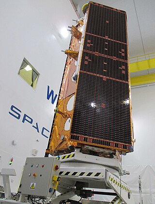
TerraSAR-X, is an imaging radar Earth observation satellite, a joint venture being carried out under a public-private-partnership between the German Aerospace Center (DLR) and EADS Astrium. The exclusive commercial exploitation rights are held by the geo-information service provider Astrium. TerraSAR-X was launched on 15 June 2007 and has been in operational service since January 2008. With its twin satellite TanDEM-X, launched 21 June 2010, TerraSAR-X acquires the data basis for the WorldDEM, the worldwide and homogeneous DEM available from 2014.

Interferometric synthetic aperture radar, abbreviated InSAR, is a radar technique used in geodesy and remote sensing. This geodetic method uses two or more synthetic aperture radar (SAR) images to generate maps of surface deformation or digital elevation, using differences in the phase of the waves returning to the satellite or aircraft. The technique can potentially measure millimetre-scale changes in deformation over spans of days to years. It has applications for geophysical monitoring of natural hazards, for example earthquakes, volcanoes and landslides, and in structural engineering, in particular monitoring of subsidence and structural stability.
Astrium was an aerospace manufacturer subsidiary of the European Aeronautic Defence and Space Company (EADS) that provided civil and military space systems and services from 2006 to 2013. In 2012, Astrium had a turnover of €5.8 billion and 18,000 employees in France, Germany, the United Kingdom, Spain and the Netherlands. Astrium was a member of Institute of Space, its Applications and Technologies.
EnMAP is a German hyperspectral satellite mission to provide high accuracy hyperspectral image data of the Earth surface on a timely and frequent basis.
Airbus Defence and Space is a division of Airbus SE. It is responsible for the development and manufacturing of defence and space products, and providing related services. The division was formed in January 2014 during the corporate restructuring of European Aeronautic Defence and Space (EADS) into Airbus SE, and comprises the former Airbus Military, Astrium, and Cassidian divisions. It is said to be the second largest space company in the world.

The NASA-ISRO Synthetic Aperture Radar (NISAR) mission is a joint project between NASA and ISRO to co-develop and launch a dual-frequency synthetic aperture radar on an Earth observation satellite. The satellite will be the first radar imaging satellite to use dual frequencies. It will be used for remote sensing, to observe and understand natural processes on Earth. For example, its left-facing instruments will study the Antarctic cryosphere. With a total cost estimated at US$1.5 billion, NISAR is likely to be the world's most expensive Earth-imaging satellite.
The International Charter "Space and Major Disasters" is a non-binding charter which provides for the charitable and humanitarian acquisition and transmission of satellite data to relief organizations in the event of major disasters. Initiated by the European Space Agency and the French space agency CNES after the UNISPACE III conference held in Vienna, Austria, in July 1999, it officially came into operation on November 1, 2000, after the Canadian Space Agency signed onto the charter on October 20, 2000. Their space assets were then, respectively, ERS and ENVISAT, SPOT and Formosat, and RADARSAT.

High Resolution Wide Swath (HRWS) imaging is an important branch in synthetic aperture radar (SAR) imaging, a remote sensing technique capable of providing high resolution images independent of weather conditions and sunlight illumination. This makes SAR very attractive for the systematic observation of dynamic processes on the Earth's surface, which is useful for environmental monitoring, earth resource mapping and military systems.
Paz is a Spanish Earth observation and reconnaissance satellite launched on 22 February 2018. It is Spain's first spy satellite. The satellite is operated by Hisdesat. Paz was previously referred to as SEOSAR.
The German space programme is the set of projects funded by the government of Germany for the exploration and use of outer space. The space programme is run by the German Aerospace Center, who conduct research, plan, and implement the programme on behalf of the German federal government.

German Antarctic Receiving Station or GARS O'Higgins is a German polar research station in Antarctica.

