GOES 15

Last updated
EWS-G2
GOES-P.jpg
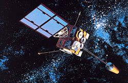
The GOES-15 satellite during pre-launch processing.
NamesGOES-P
GOES-15 (before September 22, 2023)
Mission type Weather satellite
Operator NOAA  / NASA
COSPAR ID 2010-008A OOjs UI icon edit-ltr-progressive.svg
SATCAT no. 36411
Mission duration10 years (planned)
Elapsed: 13 years, 9 months, 25 days
Spacecraft properties
Spacecraft typeGOES-N series
Bus BSS-601
Manufacturer Boeing
ITT Corporation
Power2.3 kilowatts from solar array
Start of mission
Launch date4 March 2010, 23:57 (2010-03-04UTC23:57Z) UTC
Rocket Delta IV-M+(4,2)
Launch site Cape Canaveral, SLC-37B
Contractor United Launch Alliance
Orbital parameters
Reference system Geocentric
Regime Geostationary
Longitude128° West
SlotGOES-West
Semi-major axis 42,166 kilometres (26,201 mi)
Perigee altitude 35,791.0 kilometres (22,239.5 mi)
Apogee altitude 35,800.4 kilometres (22,245.3 mi)
Inclination 0.2°
Period 1,436.2 minutes
 
GOES-15 launches from Cape Canaveral Air Force Station SLC-37B, 4 March 2010. GOES-P launched by Delta IV rocket.jpg
GOES-15 launches from Cape Canaveral Air Force Station SLC-37B, 4 March 2010.

EWS-G2 (Electro-optical Infrared Weather System Geostationary) [1] is a weather satellite of the U.S. Space Force, formerly GOES-15 (also known as GOES-P before becoming operational). The spacecraft was constructed by Boeing, and is the last of three GOES satellites to be based on the BSS-601 bus. It was launched in 2010, while the other BSS-601 GOES satellites—GOES-13 and GOES-14—were launched in May 2006 and June 2009 respectively. [2] It was the sixteenth GOES satellite to be launched.

Contents

Launch

GOES-15 was launched atop a Delta IV-M+(4,2) rocket flying from Space Launch Complex 37B at the Cape Canaveral Air Force Station. [3] [4] The launch occurred at 23:57 UTC on 4 March 2010, forty minutes into a sixty-minute launch window. Upon reaching geostationary orbit on 16 March, it was redesignated GOES-15. [4] [5] On 6 December 2011, it was activated as the GOES-West satellite, replacing GOES-11. [6]

Design

At launch, the mass of the satellite was 3,238 kilograms (7,139 lb). It has a design life of ten years. Power is supplied by a single gallium arsenide solar panel, which provides up to 2.3 kilowatts of power. A 24 cell nickel hydrogen battery is used to provide power when the satellite is not in sunlight. [7] Instruments aboard GOES-15 include a five channel multispectral imager to capture visible light and infrared images of the continental United States, a sounder to take readings of atmospheric temperature and moisture, a solar x-ray imager to detect solar flares, and instruments to monitor the magnetosphere, cosmic background radiation and charged particles. [7]

Operations

NOAA began to transition GOES-15 out of operational status at the GOES-West position in late 2018 to replace it with GOES-17. [8] [9] GOES-15 began an eastward drift maneuver on 29 October 2018 to 128° W, with all of its sensors still functioning. [9] GOES-15's drift is intended to provide additional separation from GOES-17 to prevent communication interference. GOES-15 drifted east at a rate of 0.88° per day until 7 November 2018, when it reached its new operating location of 128° West. Once GOES-17 reached its assigned longitude on 13 November 2018, additional tests were performed; provided that testing goes well, GOES-17 will become operational as GOES-West on 10 December 2018. [9] Both GOES-17 and GOES-15 operated in tandem through early 2020 to allow for assessment of the performance of GOES-17 as the GOES-West operational satellite. [9] On March 2, 2020, GOES-15 was deactivated and moved to a storage orbit, with plans to re-activate it in August 2020 to back up GOES-17 operations due to a known flaw causing many sensors to become unreliable at night during certain times of the year. [10] [11] On 22 September 2023 the satellite's ownership was officially transferred to the U.S. Space Force, taking its current designation as part of the EWS-G network. As a consequence, the spacecraft has started drifting over the Indian Ocean to reach its new assigned orbit and it's scheduled to become operational in November 2023. [1]

Media

Launch video (5 min 30 s)

Related Research Articles

<span class="mw-page-title-main">Geostationary orbit</span> Circular orbit above Earths Equator and following the direction of Earths rotation

A geostationary orbit, also referred to as a geosynchronous equatorial orbit (GEO), is a circular geosynchronous orbit 35,786 km (22,236 mi) in altitude above Earth's equator, 42,164 km (26,199 mi) in radius from Earth's center, and following the direction of Earth's rotation.

<span class="mw-page-title-main">Geostationary Operational Environmental Satellite</span> US weather satellite series

The Geostationary Operational Environmental Satellite (GOES), operated by the United States' National Oceanic and Atmospheric Administration (NOAA)'s National Environmental Satellite, Data, and Information Service division, supports weather forecasting, severe storm tracking, and meteorology research. Spacecraft and ground-based elements of the system work together to provide a continuous stream of environmental data. The National Weather Service (NWS) and the Meteorological Service of Canada use the GOES system for their North American weather monitoring and forecasting operations, and scientific researchers use the data to better understand land, atmosphere, ocean, and climate dynamics.

<span class="mw-page-title-main">Weather satellite</span> Type of satellite designed to record the state of the Earths atmosphere

A weather satellite or meteorological satellite is a type of Earth observation satellite that is primarily used to monitor the weather and climate of the Earth. Satellites can be polar orbiting, or geostationary.

<span class="mw-page-title-main">National Environmental Satellite, Data, and Information Service</span>

The National Environmental Satellite, Data, and Information Service (NESDIS) was created by the National Oceanic and Atmospheric Administration (NOAA) to operate and manage the United States environmental satellite programs, and manage the data gathered by the National Weather Service and other government agencies and departments.

The Cooperative Institute for Meteorological Satellite Studies (CIMSS) is a research institute where scientists study the use of data from geostationary and polar orbit weather satellites to improve forecasts of weather (including tropical cyclones and severe storms. CIMSS was formed through a Memorandum of Understanding between the University of Wisconsin–Madison, the National Oceanic and Atmospheric Administration and the National Aeronautics and Space Administration. CIMSS parent organization, the Space Science and Engineering Center is a primary developer and operator of environmental satellite technologies.

<span class="mw-page-title-main">GOES 1</span> NOAA weather satellite

GOES-1, designated GOES-A and SMS-C prior to entering service, was a weather satellite, developed by the NASA, operated by the United States National Oceanic and Atmospheric Administration (NOAA). It was the first Geostationary Operational Environmental Satellite (GOES) to be launched.

<span class="mw-page-title-main">GOES 14</span> NOAA weather satellite

GOES-14, known as GOES-O prior to reaching its operational orbit, is an American weather satellite, which is part of the US National Oceanic and Atmospheric Administration (NOAA)'s Geostationary Operational Environmental Satellite (GOES) system. The spacecraft was built by Boeing and is based on the BSS-601 bus. It is the second of three GOES satellites to use the BSS-601 bus, after GOES-13, which was launched in May 2006.

<span class="mw-page-title-main">GOES 13</span> U.S. Space Force weather satellite

EWS-G1 is a weather satellite of the U.S. Space Force, formerly GOES-13 and part of the National Oceanic and Atmospheric Administration's Geostationary Operational Environmental Satellite system. On 14 April 2010, GOES-13 became the operational weather satellite for GOES-East. It was replaced by GOES-16 on 18 December 2017 and on 8 January 2018 its instruments were shut off and it began its three-week drift to an on-orbit storage location at 60.0° West longitude, arriving on 31 January 2018. It remained there as a backup satellite in case one of the operational GOES satellites had a problem until early July 2019, when it started to drift westward and was being transferred to the U.S. Air Force, and then the U.S. Space Force.

<span class="mw-page-title-main">GOES 12</span> NOAA weather satellite

GOES-12, known as GOES-M before becoming operational, is an American weather satellite, which is part of the US National Oceanic and Atmospheric Administration's Geostationary Operational Environmental Satellite system. It was launched on July 23, 2001, and spent its first 21 months in space as an on-orbit spare. From April 2003, the satellite took over the GOES-East position, providing coverage of the eastern half of the continental United States. In April 2010, GOES-East operations were taken over by GOES-13, and GOES-12 transitioned to the GOES-South location to devote time to South American imagery. It remained at this post until it was decommissioned on August 16, 2013 and subsequently boosted to a graveyard orbit.

<span class="mw-page-title-main">GOES 11</span> NOAA weather satellite

GOES-11, known as GOES-L before becoming operational, is an American weather satellite, which is part of the US National Oceanic and Atmospheric Administration's Geostationary Operational Environmental Satellite system. It was launched in 2000, and operated at the GOES-WEST position, providing coverage of the west coast of the United States, until December 6, 2011.

<span class="mw-page-title-main">GOES 7</span> NOAA weather satellite

GOES-7, known as GOES-H before becoming operational, is an American satellite. It was originally built as a weather satellite, and formed part of the US National Oceanic and Atmospheric Administration's Geostationary Operational Environmental Satellite system. Originally built as a ground spare, GOES-H was launched in 1987 due to delays with the next series of satellites. It was operated by NOAA until 1999, before being leased to Peacesat, who use it as a communications satellite. As of 2009, it was operational over the Pacific Ocean, providing communications for the Pacific Islands. On April 12, 2012, the spacecraft was finally decommissioned and moved to a graveyard orbit.

<span class="mw-page-title-main">GOES 3</span> NOAA weather satellite

GOES-3, known as GOES-C before becoming operational, was an American geostationary weather and communications satellite. It was originally built for the National Oceanic and Atmospheric Administration as part of the Geostationary Operational Environmental Satellite system, and was launched in June 1978. It was positioned in geostationary orbit, from where it was initially used for weather forecasting in the United States. Since ceasing to function as a weather satellite in 1989, it was used as a communications satellite, and spent over thirty-eight years in operation. GOES-3 was decommissioned 29 June 2016 at the Center for Southeastern Tropical Advanced Remote Sensing facility in Miami, Florida.

<span class="mw-page-title-main">Joint Polar Satellite System</span> Constellation of American meteorology satellites

The Joint Polar Satellite System (JPSS) is the latest generation of U.S. polar-orbiting, non-geosynchronous, environmental satellites. JPSS will provide the global environmental data used in numerical weather prediction models for forecasts, and scientific data used for climate monitoring. JPSS will aid in fulfilling the mission of the U.S. National Oceanic and Atmospheric Administration (NOAA), an agency of the Department of Commerce. Data and imagery obtained from the JPSS will increase timeliness and accuracy of public warnings and forecasts of climate and weather events, thus reducing the potential loss of human life and property and advancing the national economy. The JPSS is developed by the National Aeronautics and Space Administration (NASA) for the National Oceanic and Atmospheric Administration (NOAA), who is responsible for operation of JPSS. Three to five satellites are planned for the JPSS constellation of satellites. JPSS satellites will be flown, and the scientific data from JPSS will be processed, by the JPSS – Common Ground System (JPSS-CGS).

<span class="mw-page-title-main">GOES-16</span> NOAA weather satellite

GOES-16, formerly known as GOES-R before reaching geostationary orbit, is the first of the GOES-R series of Geostationary Operational Environmental Satellites (GOES) operated by NASA and the National Oceanic and Atmospheric Administration (NOAA). GOES-16 serves as the operational geostationary weather satellite in the GOES East position at 75.2°W, providing a view centered on the Americas. GOES-16 provides high spatial and temporal resolution imagery of the Earth through 16 spectral bands at visible and infrared wavelengths using its Advanced Baseline Imager (ABI). GOES-16's Geostationary Lightning Mapper (GLM) is the first operational lightning mapper flown in geostationary orbit. The spacecraft also includes four other scientific instruments for monitoring space weather and the Sun.

<span class="mw-page-title-main">Visible Infrared Imaging Radiometer Suite</span>

The Visible Infrared Imaging Radiometer Suite (VIIRS) is a sensor designed and manufactured by the Raytheon Company on board the polar-orbiting Suomi National Polar-orbiting Partnership, NOAA-20, and NOAA-21 weather satellites. VIIRS is one of five key instruments onboard Suomi NPP, launched on October 28, 2011. VIIRS is a whiskbroom scanner radiometer that collects imagery and radiometric measurements of the land, atmosphere, cryosphere, and oceans in the visible and infrared bands of the electromagnetic spectrum.

<span class="mw-page-title-main">GOES-17</span> NOAA weather satellite

GOES-17 is an environmental satellite operated by the National Oceanic and Atmospheric Administration (NOAA). The satellite is second in the four-satellite GOES-R series. GOES-17 supports the Geostationary Operational Environmental Satellite (GOES) system, providing multi-spectral imaging for weather forecasts and meteorological and environmental research. The satellite was built by Lockheed Martin, based on the A2100A platform, and expected to have a useful life of 15 years. GOES-17 is intended to deliver high-resolution visible and infrared imagery and lightning observations of more than half the globe.

<span class="mw-page-title-main">GOES-18</span> NOAA weather satellite

GOES-18 is the third of the "GOES-R Series", the current generation of weather satellites operated by the National Oceanic and Atmospheric Administration (NOAA). The current and next satellites of the Series will extend the availability of the Geostationary Operational Environmental Satellite (GOES) satellite system until 2037. The satellite is built by Lockheed Martin in Littleton, Colorado. It is based on the A2100A satellite bus and will have an expected useful life of 15 years.

<span class="mw-page-title-main">NOAA-21</span> NASA/NOAA satellite

NOAA-21, designated JPSS-2 prior to launch, is the second of the United States National Oceanic and Atmospheric Administration (NOAA)'s latest generation of U.S. polar-orbiting, non-geosynchronous, environmental satellites called the Joint Polar Satellite System. NOAA-21 was launched on 10 November 2022 and join NOAA-20 and Suomi NPP in the same orbit. Circling the Earth from pole-to-pole, it will cross the equator about 14 times daily, providing full global coverage twice a day. It was launched with LOFTID.

GOES-U is a planned weather satellite, the fourth and last of the GOES-R series of satellites operated by the National Oceanic and Atmospheric Administration (NOAA). The GOES-R series will extend the availability of the Geostationary Operational Environmental Satellite (GOES) system until 2036. The satellite will be built by Lockheed Martin, based on the A2100 platform.

References

  1. 1 2 "Space Force accepts second weather satellite through NOAA partnership". U.S. Space Force. 22 September 2023. Retrieved 26 September 2023.
  2. Krebs, Gunter. "GOES N, O, P, Q". Gunter's Space Page. Retrieved 4 March 2010.
  3. "GOES-P Launch Blog". NASA. Retrieved 2010-03-04.
  4. 1 2 Ray, Justin. "Mission Status Center". Delta Launch Report. Spaceflight Now. Retrieved 19 March 2010.
  5. "LIVE: Delta IV set to launch GOES-P weather satellite". NASAspaceflight.com. 4 March 2010. Retrieved 4 March 2010.
  6. "NOAA activates GOES-15 satellite; deactivates GOES-11 after nearly 12 years in orbit". NOAA. Retrieved December 7, 2011.
  7. 1 2 "GOES-P Mission Operations Booklet" (PDF). United Launch Alliance. Archived from the original (PDF) on 17 July 2011. Retrieved 4 March 2010.
  8. "Get Ready to Drift: GOES-17 Begins Move to Its New Operational Position | NOAA National Environmental Satellite, Data, and Information Service (NESDIS)". www.nesdis.noaa.gov. Retrieved 28 July 2020.
  9. 1 2 3 4 "GOES-17 Transition to Operations │ GOES-R Series". www.goes-r.gov. Retrieved 2018-10-25.
  10. "GOES-16/17 Transition". NOAA. 2020-02-19. Retrieved 2020-03-03.
  11. "GOES-15 is no longer sending data". CIMSS. 2020-03-02. Retrieved 2020-03-03.