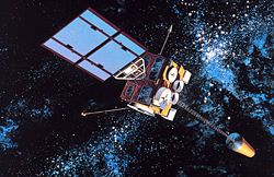
|   Artist's impression of a GOES-D series satellite  | |
| Mission type | Weather satellite | 
|---|---|
| Operator |  NOAA  / NASA (1987-1999) Peacesat (1999-2012)  | 
| COSPAR ID | 1987-022A | 
| SATCAT no. | 17561 | 
| Mission duration | 3-7 years (planned) 25 years (achieved)  | 
| Spacecraft properties | |
| Bus | HS-371 | 
| Manufacturer | Hughes | 
| Start of mission | |
| Launch date | 26 February 1987, 23:05 UTC | 
| Rocket | Delta 3914 | 
| Launch site | Cape Canaveral LC-17A | 
| Contractor | McDonnell Douglas | 
| End of mission | |
| Disposal | Decommissioned | 
| Deactivated | 12 April 2012 | 
| Orbital parameters | |
| Reference system | Geocentric | 
| Regime | Geostationary | 
| Longitude | 75° West (1987-1989) 98° West (1989-1992) 112° West (1992-1995) 135° West (1995-1999) 95° West (1999) 175° West (1999-2012)  | 
| Slot | GOES-EAST (1987-1989) GOES-WEST (1995-1999)  | 
| Eccentricity | 0.0002306 | 
| Perigee altitude | 35,879 kilometres (22,294 mi) | 
| Apogee altitude | 35,898 kilometres (22,306 mi) | 
| Inclination | 15.09° | 
| Period | 24 hours | 
GOES-7, known as GOES-H before becoming operational, is an American satellite. It was originally built as a weather satellite, and formed part of the US National Oceanic and Atmospheric Administration's Geostationary Operational Environmental Satellite system. Originally built as a ground spare, [1] GOES-H was launched in 1987 due to delays with the next series of satellites. It was operated by NOAA until 1999, before being leased to Peacesat, who use it as a communications satellite. [2] As of 2009, it was operational over the Pacific Ocean, providing communications for the Pacific Islands. On April 12, 2012, the spacecraft was finally decommissioned and moved to a graveyard orbit. [3]
GOES-H was launched aboard a McDonnell Douglas Delta 3914 rocket, flying from Launch Complex 17A at the Cape Canaveral Air Force Station. [4] The launch occurred at 23:05 GMT on 26 February 1987. [4] The launch had originally been scheduled for late 1986, but was delayed after GOES-G failed to achieve orbit. [5] It was built by Hughes Space and Communications, based on the HS-371 satellite bus, [6] and was the last of five GOES-D series satellites to be launched. [7]
 Following launch, GOES-7 was positioned in geostationary orbit at a longitude of 75° West, [8] where it underwent on-orbit testing before being activated in the GOES-EAST slot of the constellation.
Due to the loss of GOES-G, and delays in the development of the GOES-I series spacecraft, no reserve satellites were available in the late 1980s and early 1990s. After the imager on the GOES-6 satellite failed in 1989, GOES-7 was left as the only operational GOES satellite. [9] It was moved to 98° West to cover the whole of the continental United States. In 1992, Meteosat 3 was leased from Eumetsat to take over GOES-EAST operations, allowing GOES-8 to be moved 112° West. When GOES-8 entered service in 1995, it replaced Meteosat 3, and GOES-7 was moved to the GOES-WEST position at 135° West. It remained in service until its retirement from service in 1996, [10] at which time it was moved to 95° West. It was then transferred to Peacesat, and positioned at 175° West [11] [12] until its final retirement and disposal in 2012.
It is the only satellite to have been operated as both GOES-EAST and GOES-WEST in the course of normal operations. GOES-10 has been used as both GOES-EAST and GOES-WEST, however its operations as GOES-EAST were as a backup during an outage of GOES-12, and the satellite was not moved to the GOES-EAST orbital position.