
The Synchronous Meteorological Satellite (SMS) program, was a program where NASA developed two weather satellites; which were placed into geosynchronous orbit.
The Synchronous Meteorological Satellite (SMS) program, was a program where NASA developed two weather satellites; which were placed into geosynchronous orbit.
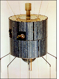
SMS-1 was launched May 17, 1974 and SMS-2 was launched February 6, 1975. [1] [2] Both satellites were carried to orbit by Delta 2914 rockets. [3] The program was initiated after the successes achieved by the Applications Technology Satellite (ATS) research satellites, which demonstrated the feasibility of using satellites in geosynchronous orbit for meteorology. The Geostationary Operational Environmental Satellite (GOES) program, which now supports weather forecasting, severe storm tracking, and meteorology research in the United States, followed immediately after the SMS program; the GOES 1 satellite was initially designated SMS-C. [4] SMS-1 and SMS-2; and GOES-1, GOES-2, and GOES-3; were essentially identical. [5]
| Designation | Launch Date/Time (UTC) | Rocket | Launch Site | Longitude | First Image | Status | Retirement | Remarks | |
|---|---|---|---|---|---|---|---|---|---|
| Launch | Operational | ||||||||
SMS series satellites | |||||||||
| SMS-A | SMS-1 | May 17, 1974 | Delta 2914 | ||||||
| SMS-B | SMS-2 | February 6, 1975 | Delta 2914 | ||||||
SMS-derived satellites | |||||||||
| SMS-C GOES-A | GOES 1 | October 16, 1975, 22:40 | Delta 2914 | CCAFS LC-17A | October 25, 1975 | Retired | March 7, 1985 [6] | ||
| SMS-D GOES-B | GOES 2 | June 16, 1977, 10:51 | Delta 2914 | CCAFS LC-17B | 60°W | Retired | 1993 [7] | Reactivated as comsat in 1995, [7] finally deactivated in May 2001 | |
| SMS-E GOES-C | GOES 3 | June 16, 1978, 10:49 | Delta 2914 | CCAFS LC-17B | Retired | 1993 [8] | Reactivated as comsat in 1995, [8] was decommissioned 29 June 2016 | ||

The Geostationary Operational Environmental Satellite (GOES), operated by the United States' National Oceanic and Atmospheric Administration (NOAA)'s National Environmental Satellite, Data, and Information Service division, supports weather forecasting, severe storm tracking, and meteorology research. Spacecraft and ground-based elements of the system work together to provide a continuous stream of environmental data. The National Weather Service (NWS) and the Meteorological Service of Canada use the GOES system for their North American weather monitoring and forecasting operations, and scientific researchers use the data to better understand land, atmosphere, ocean, and climate dynamics.

The Nimbus satellites were second-generation U.S. robotic spacecraft launched between 1964 and 1978 used for meteorological research and development. The spacecraft were designed to serve as stabilized, Earth-oriented platforms for the testing of advanced systems to sense and collect atmospheric science data. Seven Nimbus spacecraft have been launched into near-polar, Sun-synchronous orbits beginning with Nimbus 1 on August 28, 1964. On board the Nimbus satellites are various instrumentation for imaging, sounding, and other studies in different spectral regions. The Nimbus satellites were launched aboard Thor-Agena rockets and Delta rockets.

The Defense Meteorological Satellite Program (DMSP) monitors meteorological, oceanographic, and solar-terrestrial physics for the United States Department of Defense. The program is managed by the United States Space Force with on-orbit operations provided by the National Oceanic and Atmospheric Administration (NOAA). The mission of the satellites was revealed in March 1973. They provide cloud cover imagery from polar orbits that are Sun-synchronous at nominal altitude of 830 km (520 mi).

The Scout family of rockets were American launch vehicles designed to place small satellites into orbit around the Earth. The Scout multistage rocket was the first orbital launch vehicle to be entirely composed of solid fuel stages. It was also the only vehicle of that type until the successful launch of the Japanese Lambda 4S in 1970.

Fēngyún are China's meteorological satellites. Launched since 1988 into polar Sun-synchronous and geosynchronous orbit, each three-axis stabilized Fengyun satellite is built by the Shanghai Academy of Spaceflight Technology (SAST) and operated by the China Meteorological Administration (CMA). To date, China has launched twenty-one Fengyun satellites in four classes. Fengyun 1 and Fengyun 3 satellites are in polar, Sun-synchronous orbit and Low Earth orbit while Fengyun 2 and 4 are geosynchronous orbit.
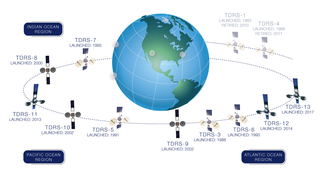
A tracking and data relay satellite (TDRS) is a type of communications satellite that forms part of the Tracking and Data Relay Satellite System (TDRSS) used by NASA and other United States government agencies for communications to and from independent "User Platforms" such as satellites, balloons, aircraft, the International Space Station, and remote bases like the Amundsen-Scott South Pole Station. This system was designed to replace an existing worldwide network of ground stations that had supported all of NASA's crewed flight missions and uncrewed satellites in low-Earth orbits. The primary system design goal was to increase the amount of time that these spacecraft were in communication with the ground and improve the amount of data that could be transferred. These TDRSS satellites are all designed and built to be launched to and function in geosynchronous orbit, 35,786 km (22,236 mi) above the surface of the Earth.
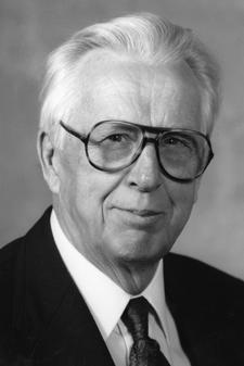
Verner Edward Suomi was a Finnish-American educator, inventor, and scientist. He is considered the father of satellite meteorology. He invented the Spin Scan Radiometer, which for many years was the instrument on the GOES weather satellites that generated the time sequences of cloud images seen on television weather shows. The Suomi NPP polar orbiting satellite, launched in 2011, was named in his honor.
The Applications Technology Satellites (ATS) were a series of experimental satellites launched by NASA, under the supervision of, among others, Wernher von Braun. The program was launched in 1966 to test the feasibility of placing a satellite into geosynchronous orbit. The satellites were primarily designed to act as communication satellites, but also carried equipment related to meteorology and navigation. ATS-6 was the world's first educational satellite as well as world's first experimental Direct Broadcast Satellite (DBS) as part of the Satellite Instructional Television Experiment (SITE) between NASA and ISRO.
The National Environmental Satellite, Data, and Information Service (NESDIS) was created by the National Oceanic and Atmospheric Administration (NOAA) to operate and manage the United States environmental satellite programs, and manage the data gathered by the National Weather Service and other government agencies and departments.

GOES-1, designated GOES-A and SMS-C prior to entering service, was a weather satellite, developed by the NASA, operated by the United States National Oceanic and Atmospheric Administration (NOAA). It was the first Geostationary Operational Environmental Satellite (GOES) to be launched.
Marisat satellites were the first maritime telecommunications satellites and were designed to provide dependable telecommunications for commercial shipping and the U.S. Navy from stable geosynchronous orbital locations over the three major ocean regions. The three Marisat satellites, F1, F2, and F3, were built by Hughes Aircraft Corporation (HAC) for COMSAT Corporation starting in 1973. The satellites were designed to provide maritime telecommunications services in three large ocean areas, the Atlantic Ocean, the Pacific Ocean, and the Indian Ocean, and were located at 72.5° East longitude, 176.5° E, and 345° E in the geosynchronous orbital arc. The three-satellite Marisat system served as the initial INMARSAT constellation.

GOES-7, known as GOES-H before becoming operational, is an American satellite. It was originally built as a weather satellite, and formed part of the US National Oceanic and Atmospheric Administration's Geostationary Operational Environmental Satellite system. Originally built as a ground spare, GOES-H was launched in 1987 due to delays with the next series of satellites. It was operated by NOAA until 1999, before being leased to Peacesat, who use it as a communications satellite. As of 2009, it was operational over the Pacific Ocean, providing communications for the Pacific Islands. On April 12, 2012, the spacecraft was finally decommissioned and moved to a graveyard orbit.

GOES-2, known as GOES-B before becoming operational, was a geostationary weather satellite which was operated by the United States National Oceanic and Atmospheric Administration as part of the Geostationary Operational Environmental Satellite system. GOES-2 was built by Ford Aerospace, and was based on the satellite bus developed for the Synchronous Meteorological Satellite programme. At launch it had a mass of 295 kilograms (650 lb). It was positioned in geostationary orbit, from where it was used for weather forecasting in the United States. Following its retirement as a weather satellite, it was used as a communications satellite until its final decommissioning in 2001.

GOES-3, known as GOES-C before becoming operational, was an American geostationary weather and communications satellite. It was originally built for the National Oceanic and Atmospheric Administration as part of the Geostationary Operational Environmental Satellite system, and was launched in June 1978. It was positioned in geostationary orbit, from where it was initially used for weather forecasting in the United States. After ceasing to function as a weather satellite in 1989, it was used as a communications satellite, and spent over thirty-eight years in operation. GOES-3 was decommissioned 29 June 2016 at the Center for Southeastern Tropical Advanced Remote Sensing facility in Miami, Florida.

GOES-4, known as GOES-D before becoming operational, was a geostationary weather satellite which was operated by the United States National Oceanic and Atmospheric Administration as part of the Geostationary Operational Environmental Satellite system. Launched in 1980, it was used for weather forecasting in the United States, and later in Europe. Following its retirement it became the first satellite to be sent into a graveyard orbit.
GOES-5, known as GOES-E before becoming operational, was a geostationary weather satellite which was operated by the United States National Oceanic and Atmospheric Administration as part of the Geostationary Operational Environmental Satellite system. Launched in 1981, it was used for weather forecasting in the United States.
GOES-6, known as GOES-F before becoming operational, was a geostationary weather satellite which was operated by the United States National Oceanic and Atmospheric Administration as part of the Geostationary Operational Environmental Satellite system. Launched in 1983, it was used for weather forecasting in the United States.
Kosmos 23, also known as Omega No.2, was a satellite which was launched by the Soviet Union in 1963. It was an Omega satellite, derived from the Dnepropetrovsk Sputnik series. It was a 347 kilograms (765 lb) spacecraft, which was built by the Yuzhnoye Design Office, and was used to conduct experiments with the use of gyroscopes to control spacecraft, for VNIIEM.
ATS-1, also designated ATS-B or Advanced Tech. Sat. 1, was an experimental geostationary satellite, launched in 1966, and part of the Applications Technology Satellites Program. Though intended as a communications satellite rather than as a weather satellite, it carried the Spin Scan Cloud Camera developed by Verner E. Suomi and Robert Parent at the University of Wisconsin.
| SMS (predecessor) |  | |
|---|---|---|
| SMS derived | ||
| 1st generation | ||
| 2nd generation | ||
| 3rd generation | ||
| 4th generation | ||