
The Geostationary Operational Environmental Satellite (GOES), operated by the United States' National Oceanic and Atmospheric Administration (NOAA)'s National Environmental Satellite, Data, and Information Service division, supports weather forecasting, severe storm tracking, and meteorology research. Spacecraft and ground-based elements of the system work together to provide a continuous stream of environmental data. The National Weather Service (NWS) and the Meteorological Service of Canada use the GOES system for their North American weather monitoring and forecasting operations, and scientific researchers use the data to better understand land, atmosphere, ocean, and climate dynamics.

A weather satellite or meteorological satellite is a type of Earth observation satellite that is primarily used to monitor the weather and climate of the Earth. Satellites can be polar orbiting, or geostationary.
The Cooperative Institute for Meteorological Satellite Studies (CIMSS) is a research institute where scientists study the use of data from geostationary and polar orbit weather satellites to improve forecasts of weather (including tropical cyclones and severe storms. CIMSS was formed through a Memorandum of Understanding between the University of Wisconsin–Madison, the National Oceanic and Atmospheric Administration and the National Aeronautics and Space Administration. CIMSS parent organization, the Space Science and Engineering Center is a primary developer and operator of environmental satellite technologies.

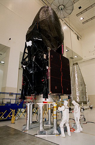
GOES-1, designated GOES-A and SMS-C prior to entering service, was a weather satellite, developed by the NASA, operated by the United States National Oceanic and Atmospheric Administration (NOAA). It was the first Geostationary Operational Environmental Satellite (GOES) to be launched.
TDRS-8, known before launch as TDRS-H, is an American communications satellite, of second generation, which is operated by NASA as part of the Tracking and Data Relay Satellite System. It was constructed by Boeing and is based on the BSS-601 satellite bus.

EWS-G1 is a weather satellite of the U.S. Space Force, formerly GOES-13 and part of the National Oceanic and Atmospheric Administration's Geostationary Operational Environmental Satellite system. On 14 April 2010, GOES-13 became the operational weather satellite for GOES-East. It was replaced by GOES-16 on 18 December 2017 and on 8 January 2018 its instruments were shut off and it began its three-week drift to an on-orbit storage location at 60.0° West longitude, arriving on 31 January 2018. It remained there as a backup satellite in case one of the operational GOES satellites had a problem until early July 2019, when it started to drift westward and was being transferred to the U.S. Air Force, and then the U.S. Space Force.

GOES-12, known as GOES-M before becoming operational, is an American weather satellite, which is part of the US National Oceanic and Atmospheric Administration's Geostationary Operational Environmental Satellite system. It was launched on July 23, 2001, and spent its first 21 months in space as an on-orbit spare. From April 2003, the satellite took over the GOES-East position, providing coverage of the eastern half of the continental United States. In April 2010, GOES-East operations were taken over by GOES-13, and GOES-12 transitioned to the GOES-South location to devote time to South American imagery. It remained at this post until it was decommissioned on August 16, 2013 and subsequently boosted to a graveyard orbit.
GOES-11, known as GOES-L before becoming operational, is an American weather satellite, which is part of the US National Oceanic and Atmospheric Administration's Geostationary Operational Environmental Satellite system. It was launched in 2000, and operated at the GOES-WEST position, providing coverage of the west coast of the United States, until December 6, 2011.

GOES-10, known as GOES-K before becoming operational, was an American weather satellite, which formed part of the US National Oceanic and Atmospheric Administration's Geostationary Operational Environmental Satellite system. It was launched in 1997, and after completing operations as part of the main GOES system, it was kept online as a backup spacecraft until December 2009, providing coverage of South America as GOES-SOUTH, and being used to assist with hurricane predictions for North America. It was retired and maneuvered to a graveyard orbit on 1 December 2009.

GOES-9, known as GOES-J before becoming operational, was an American weather satellite, which formed part of the U.S. National Oceanic and Atmospheric Administration's Geostationary Operational Environmental Satellite system. It was launched in 1995, and operated until 2007 when it was retired and boosted to a graveyard orbit. At launch, the satellite had a mass of 2,105 kilograms (4,641 lb), and an expected operational lifespan of three years. It was built by Space Systems/Loral, based on the LS-1300 satellite bus, and was the second of five GOES-I series satellites to be launched.
GOES-8, known as GOES-I before becoming operational, was an American weather satellite, which formed part of the US National Oceanic and Atmospheric Administration's Geostationary Operational Environmental Satellite system. It was launched in 1994, and operated until 2004 when it was retired and boosted to a graveyard orbit. At launch, the satellite had a mass of 2,105 kilograms (4,641 lb), and an expected operational lifespan of three or five years. It was built by Space Systems/Loral, based on the LS-1300 satellite bus, and was the first of five GOES-I series satellites to be launched.

GOES-7, known as GOES-H before becoming operational, is an American satellite. It was originally built as a weather satellite, and formed part of the US National Oceanic and Atmospheric Administration's Geostationary Operational Environmental Satellite system. Originally built as a ground spare, GOES-H was launched in 1987 due to delays with the next series of satellites. It was operated by NOAA until 1999, before being leased to Peacesat, who use it as a communications satellite. As of 2009, it was operational over the Pacific Ocean, providing communications for the Pacific Islands. On April 12, 2012, the spacecraft was finally decommissioned and moved to a graveyard orbit.

TDRS-10, known before launch as TDRS-J, is an American communications satellite which is operated by NASA as part of the Tracking and Data Relay Satellite System. It was constructed by the Boeing Satellite Development Center, formerly Hughes Space and Communications, and is based on the BSS-601 satellite bus. It was the third and final Advanced TDRS, or second-generation Tracking and Data Relay Satellite, to be launched.

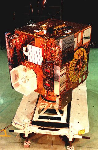
GOES-2, known as GOES-B before becoming operational, was a geostationary weather satellite which was operated by the United States National Oceanic and Atmospheric Administration as part of the Geostationary Operational Environmental Satellite system. GOES-2 was built by Ford Aerospace, and was based on the satellite bus developed for the Synchronous Meteorological Satellite programme. At launch it had a mass of 295 kilograms (650 lb). It was positioned in geostationary orbit, from where it was used for weather forecasting in the United States. Following its retirement as a weather satellite, it was used as a communications satellite until its final decommissioning in 2001.

GOES-3, known as GOES-C before becoming operational, was an American geostationary weather and communications satellite. It was originally built for the National Oceanic and Atmospheric Administration as part of the Geostationary Operational Environmental Satellite system, and was launched in June 1978. It was positioned in geostationary orbit, from where it was initially used for weather forecasting in the United States. Since ceasing to function as a weather satellite in 1989, it was used as a communications satellite, and spent over thirty-eight years in operation. GOES-3 was decommissioned 29 June 2016 at the Center for Southeastern Tropical Advanced Remote Sensing facility in Miami, Florida.

EWS-G2 is a weather satellite of the U.S. Space Force, formerly GOES-15. The spacecraft was constructed by Boeing, and is the last of three GOES satellites to be based on the BSS-601 bus. It was launched in 2010, while the other BSS-601 GOES satellites—GOES-13 and GOES-14—were launched in May 2006 and June 2009 respectively. It was the sixteenth GOES satellite to be launched.
GOES-16, formerly known as GOES-R before reaching geostationary orbit, is the first of the GOES-R series of Geostationary Operational Environmental Satellites (GOES) operated by NASA and the National Oceanic and Atmospheric Administration (NOAA). GOES-16 serves as the operational geostationary weather satellite in the GOES East position at 75.2°W, providing a view centered on the Americas. GOES-16 provides high spatial and temporal resolution imagery of the Earth through 16 spectral bands at visible and infrared wavelengths using its Advanced Baseline Imager (ABI). GOES-16's Geostationary Lightning Mapper (GLM) is the first operational lightning mapper flown in geostationary orbit. The spacecraft also includes four other scientific instruments for monitoring space weather and the Sun.

The Boeing 601 is a communications satellite bus designed in 1985 and introduced in 1987 by Hughes Space and Communications Company. The series was extremely popular in the 1990s, with more than 84 purchased by customers globally. The more advanced 601HP derivative was introduced in 1995. Hughes, and the 601 platforms, were acquired by Boeing in 2000.

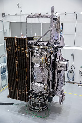
GOES-17 is an environmental satellite operated by the National Oceanic and Atmospheric Administration (NOAA). The satellite is second in the four-satellite GOES-R series. GOES-17 supports the Geostationary Operational Environmental Satellite (GOES) system, providing multi-spectral imaging for weather forecasts and meteorological and environmental research. The satellite was built by Lockheed Martin, based on the A2100A platform, and expected to have a useful life of 15 years. GOES-17 is intended to deliver high-resolution visible and infrared imagery and lightning observations of more than half the globe.
GOES-18 is the third of the "GOES-R Series", the current generation of weather satellites operated by the National Oceanic and Atmospheric Administration (NOAA). The current and next satellites of the Series will extend the availability of the Geostationary Operational Environmental Satellite (GOES) satellite system until 2037. The satellite is built by Lockheed Martin in Littleton, Colorado. It is based on the A2100A satellite bus and will have an expected useful life of 15 years.


