The Near Earth Network (NEN, formerly GN or Ground Network) provides orbital communications support for near-Earth orbiting customer platforms via various ground stations, operated by NASA and other space agencies. It uses a number of different dishes scattered around the globe. The antennas must be able to move fast for tracking of objects in low Earth orbit (LEO). The NEN and Space Network (SN) combined were previously referred to as the Spaceflight Tracking and Data Network (STDN). [1]
NEN uses several stations run by NASA:
NEN uses Stations run by KSAT — Kongsberg Satellite Services:
NEN uses a Station run by SANSA — South African National Space Agency:
NEN uses Stations run by SSC — Swedish Space Corporation
Also under contract was Poker Flat Research Range. Additionally, the MILA and Wallops stations provide pre-launch, launch, and landing communications support for the Space Shuttle program.
The NEN falls under NASA's SOMD (Space Operations Mission Directorate), interoperating with the SCaN Program offices. The Goddard Space Flight Center Ground Network Project has responsibility for maintaining the NEN, as well as implementing the Satellite laser ranging (SLR) Network.
The NEN was slated to support the Constellation Program, including the Ares launch vehicle, NISN (NASA Integrated Services Network), FDF (Flight Dynamics Facilities), KSC Launch Control Center, and the Constellation Mission Control Center (MCC). Constellation has since been canceled.

A communications satellite is an artificial satellite that relays and amplifies radio telecommunication signals via a transponder; it creates a communication channel between a source transmitter and a receiver at different locations on Earth. Communications satellites are used for television, telephone, radio, internet, and military applications. Many communications satellites are in geostationary orbit 22,236 miles (35,785 km) above the equator, so that the satellite appears stationary at the same point in the sky; therefore the satellite dish antennas of ground stations can be aimed permanently at that spot and do not have to move to track the satellite. Others form satellite constellations in low Earth orbit, where antennas on the ground have to follow the position of the satellites and switch between satellites frequently.

The Goddard Space Flight Center (GSFC) is a major NASA space research laboratory located approximately 6.5 miles (10.5 km) northeast of Washington, D.C., in Greenbelt, Maryland, United States. Established on May 1, 1959, as NASA's first space flight center, GSFC employs about 10,000 civil servants and contractors. Named for American rocket propulsion pioneer Robert H. Goddard, it is one of ten major NASA field centers. GSFC is partially within the former Goddard census-designated place; it has a Greenbelt mailing address.
The U.S. Tracking and Data Relay Satellite System is a network of American communications satellites and ground stations used by NASA for space communications. The system was designed to replace an existing network of ground stations that had supported all of NASA's crewed flight missions. The prime design goal was to increase the time spacecraft were in communication with the ground and improve the amount of data that could be transferred. Many Tracking and Data Relay Satellites were launched in the 1980s and 1990s with the Space Shuttle and made use of the Inertial Upper Stage, a two-stage solid rocket booster developed for the shuttle. Other TDRS were launched by Atlas IIa and Atlas V rockets.
Orbital Sciences Corporation was an American company specializing in the design, manufacture, and launch of small- and medium- class space and launch vehicle systems for commercial, military and other government customers. In 2014, Orbital merged with Alliant Techsystems (ATK) to create a new company called Orbital ATK, which in turn was purchased by Northrop Grumman in 2018.
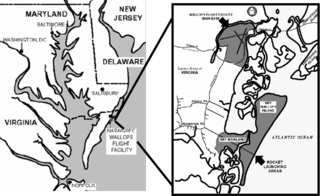
Wallops Flight Facility (WFF) is a rocket launch site on Wallops Island on the Eastern Shore of Virginia, United States, just east of the Delmarva Peninsula and approximately 100 miles (160 km) north-northeast of Norfolk. The facility is operated by the Goddard Space Flight Center in Greenbelt, Maryland, and primarily serves to support science and exploration missions for NASA and other federal agencies. WFF includes an extensively instrumented range to support launches of more than a dozen types of sounding rockets; small expendable suborbital and orbital rockets; high-altitude balloon flights carrying scientific instruments for atmospheric and astronomical research; and, using its Research Airport, flight tests of aeronautical research aircraft, including unmanned aerial vehicles.

Milstar is a constellation of military communications satellites in geosynchronous orbit, which are operated by the United States Space Force, and provide secure and jam-resistant worldwide communications to meet the requirements of the Armed Forces of the United States. Six spacecraft were launched between 1994 and 2003, of which only five were operational after launch; the third launch failed, both damaging the satellite and leaving it in an unusable orbit.

The Poker Flat Research Range (PFRR) is a launch facility and rocket range for sounding rockets in the U.S. state of Alaska, located on a 5,132-acre (20.77 km2) site at Chatanika, about 30 miles (50 km) northeast of Fairbanks and 1.5 degrees south of the Arctic Circle. More than 1,700 launches have been conducted at the range to study the Earth's atmosphere and the interaction between the atmosphere and the space environment. Areas studied at PFRR include the aurora, plasma physics, the ozone layer, solar proton events, Earth's magnetic field, and ultraviolet radiation. Rockets launched at PFRR have attained an apogee of 930 miles (1,500 km).
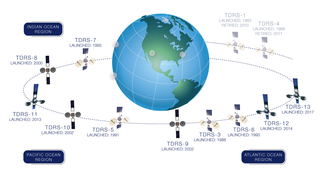
A tracking and data relay satellite (TDRS) is a type of communications satellite that forms part of the Tracking and Data Relay Satellite System (TDRSS) used by NASA and other United States government agencies for communications to and from independent "User Platforms" such as satellites, balloons, aircraft, the International Space Station, and remote bases like the Amundsen-Scott South Pole Station. This system was designed to replace an existing worldwide network of ground stations that had supported all of NASA's crewed flight missions and uncrewed satellites in low-Earth orbits. The primary system design goal was to increase the amount of time that these spacecraft were in communication with the ground and improve the amount of data that could be transferred. These TDRSS satellites are all designed and built to be launched to and function in geosynchronous orbit, 35,786 km (22,236 mi) above the surface of the Earth.
The Manned Space Flight Network was a set of tracking stations built to support the American Mercury, Gemini, Apollo, and Skylab space programs.
Space Network (SN) is a NASA program that combines space and ground elements to support spacecraft communications in Earth vicinity. The SN Project Office at Goddard Space Flight Center (GSFC) manages the SN, which consists of:

The Space Communications and Navigation (SCaN) program places the three prime NASA space communications networks, Space Network (SN), Near Earth Network (NEN), and the Deep Space Network (DSN), under one Management and Systems Engineering umbrella. It was established in 2006. It was previously known as the Space Communications & Data Systems (SCDS) Program.
The Iridium satellite constellation provides L band voice and data information coverage to satellite phones, satellite messenger communication devices and integrated transceivers. Iridium Communications owns and operates the constellation, additionally selling equipment and access to its services. It was conceived by Bary Bertiger, Raymond J. Leopold and Ken Peterson in late 1987 and then developed by Motorola on a fixed-price contract from July 29, 1993, to November 1, 1998, when the system became operational and commercially available.
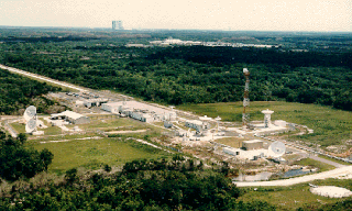
The Merritt Island Spaceflight Tracking and Data Network station, known in NASA parlance as MILA, was a radio communications and spacecraft tracking complex located on 61 acres (0.25 km2) at the Kennedy Space Center (KSC) in Florida. The name MILA was an acronym for the "Merritt Island Launch Annex" to Cape Canaveral Air Force Station, which was how the site was referred to when spacecraft launches were primarily originating from the adjacent military installation. MILA's arrays of antennas provided various communications and data services between spacecraft and NASA centers, as well as tracked and ranged moving spacecraft. In its final years, it served as the primary voice and data link during the first 7½ minutes of Space Shuttle launches, and the final 13 minutes of shuttle landings at KSC. Though it occupied land at KSC, MILA was operated and managed by the Goddard Space Flight Center.
The NASA (Ground) Communications System (NASCOM) manages terrestrial communications between ground stations, mission control centers, and other elements of spacecraft ground segments. Established in 1964, NASCOM provides worldwide, near real-time, transmission of commands, telemetry, voice, and television signals. It is managed out of NASA's Goddard Space Flight Center in Greenbelt, Maryland.

The Joint Polar Satellite System (JPSS) is the latest generation of U.S. polar-orbiting, non-geosynchronous, environmental satellites. JPSS will provide the global environmental data used in numerical weather prediction models for forecasts, and scientific data used for climate monitoring. JPSS will aid in fulfilling the mission of the U.S. National Oceanic and Atmospheric Administration (NOAA), an agency of the Department of Commerce. Data and imagery obtained from the JPSS will increase timeliness and accuracy of public warnings and forecasts of climate and weather events, thus reducing the potential loss of human life and property and advancing the national economy. The JPSS is developed by the National Aeronautics and Space Administration (NASA) for the National Oceanic and Atmospheric Administration (NOAA), who is responsible for operation of JPSS. Three to five satellites are planned for the JPSS constellation of satellites. JPSS satellites will be flown, and the scientific data from JPSS will be processed, by the JPSS – Common Ground System (JPSS-CGS).
There are NASA facilities across the United States and around the world. NASA Headquarters in Washington, DC provides overall guidance and political leadership to the agency. There are 10 NASA field centers, which provide leadership for and execution of NASA's work. All other facilities fall under the leadership of at least one of these field centers. Some facilities serve more than one application for historic or administrative reasons. NASA has used or supported various observatories and telescopes, and an example of this is the NASA Infrared Telescope Facility. In 2013 a NASA Office of the Inspector General's (OIG) Report recommended a Base Realignment and Closure Commission (BRAC) style organization to consolidate NASA's little used facilities. The OIG determined at least 33 of NASA's 155 facilities were underutilized.
The Alaska Satellite Facility (ASF) is a data processing facility and satellite-tracking ground station within the Geophysical Institute at the University of Alaska Fairbanks. The facility’s mission is to make remote-sensing data accessible Its work is central to polar processes research including wetlands, glaciers, sea ice, climate change, permafrost, flooding and land cover such as changes in the Amazon rainforest.
Planet Labs PBC is a publicly trading American Earth imaging company based in San Francisco, California. Their goal is to image the entirety of the Earth daily to monitor changes and pinpoint trends.

A ground segment consists of all the ground-based elements of a space system used by operators and support personnel, as opposed to the space segment and user segment. The ground segment enables management of a spacecraft, and distribution of payload data and telemetry among interested parties on the ground. The primary elements of a ground segment are:
Kosmos 2126, also known as Cosmos 2126, was a Russian Satellite that was part of the Strela-1M generation of communications satellites that operated in low Earth orbit to collect (store) information then forward (dump) it to a ground station when overhead of its ground station. Kosmos-2126 was launched in 1991 from the Plesetsk Cosmodrome.