Troll Satellite Station

Last updated

Troll Satellite Station
Troll research station Antarctica.JPG
Alternative namesTrollSat OOjs UI icon edit-ltr-progressive.svg
Location(s) Troll, Antarctic Treaty area
Coordinates 72°01′00″S2°32′00″E / 72.0167°S 2.5333°E / -72.0167; 2.5333 Coordinates: 72°01′00″S2°32′00″E / 72.0167°S 2.5333°E / -72.0167; 2.5333 OOjs UI icon edit-ltr-progressive.svg
Telescope style ground station   OOjs UI icon edit-ltr-progressive.svg
Antarctica relief location map.jpg
Red pog.svg
Location of Troll Satellite Station

Troll Satellite Station (Norwegian : Troll satellittstasjon), commonly abbreviated TrollSat, is a satellite ground station located at Troll in Queen Maud Land, Antarctica. The earth station is owned by Kongsberg Satellite Services (KSAT), a joint venture between the Kongsberg Group and the Norwegian Space Center. The radomes are located on top of Jutulsessen, a nunatak area next to the research station at Troll. The research station is operated by the Norwegian Polar Institute, which also maintains the earth station. TrollSat started operations on 1 March 2007 and was officially opened on 20 January 2008.

Contents

The earth station serves low Earth orbit satellites and consists of a 7.3-meter (24 ft) antenna capable of S band and X band reception. Information is relayed using a 4.8-meter (16 ft) and a 7.6-meter (25 ft) C band uplink. Operations control is carried out by KSAT in Tromsø, Norway. Satellites using TrollSat include Radarsat, GeoEye, WorldView, Galileo and CHEOPS. The system is coordinated with Svalbard Satellite Station (SvalSat) in Longyearbyen, Norway, which combined offer downloading twice per orbit.

History

Troll was established as a research station by the Norwegian Polar Institute in 1990. [1] The station took its name from the surrounding jagged mountains, which resemble trolls of Norse mythology. [2] Already at this time, there were proposals by the Norwegian Space Centre to establish an earth station at Troll, but the lack of all-year activity stranded the plans. [3] Instead, SvalSat was established to serve as an earth station for NASA's Earth Observing System (EOS). [4] Longyearbyen was selected because of its high latitude, which allows all satellites with an orbit above 500 kilometers (300 mi) to use only a single ground station—yet download from every orbit. [5] The Svalbard facility opened on 15 April 1999 [6] and was originally owned by the Norwegian Space Centre. Kongsberg Satellite Services was established in 2002 to jointly operate SvalSat and Tromsø Satellite Station (TSS). [7]

In 2003, Norwegian authorities decided to extend its operations in Antarctica by establishing an all-year research station. By then, Norway was the only country with a territorial claim to Antarctica to not have an all-year research station on the continent. [1] Construction was carried out from December 2004 through February 2005. [8] To ease logistics, Norway took the initiative to establish Dronning Maud Land Air Network (DROMLAN), a cooperation between the countries with bases in Queen Maud Land to streamline transport costs. The permanent Troll Airfield was opened on 11 February 2005. [1]

The basis for TrollSat was an agreement signed in 2006 between the Norwegian Polar Institute, the Norwegian Space Centre and Kongsberg Satellite Services. It specified that the Space Centre would install a Kongsberg-built radome, while the Polar Institute would provide power and undertake maintenance. In exchange, they could freely use the earth station for their own transmission needs. The commercial activities would be carried out by Kongsberg Satellite Services. A concern was raised regarding if satellite downloading would violate the Antarctic Treaty, but the Ministry of Foreign Affairs negated. [9] The station started operations on 1 March 2007 [10] and was officially opened by Prime Minister of Norway, Jens Stoltenberg. [11]

Operation

The research station at Troll acts as a maintenance base for the radomes Troll research station Antarctica.JPG
The research station at Troll acts as a maintenance base for the radomes

TrollSat is owned and operated by Kongsberg Satellite Services (KSAT), which is again equally owned by Kongsberg Defence and Aerospace and the Norwegian Space Centre, the latter which is again owned by the Ministry of Trade and Industry. [12] KSAT is not tied to a particular operator of satellites and the antennas communicate with multiple satellites, thus reducing costs compared to dedicated ground stations. For a typical satellite, data is delivered to the end customer no more than thirty minutes after downloading. [13]

KSAT operates two polar ground stations optimized for low Earth orbit (LEO) satellites, the other being SvalSat at Longyearbyen in Svalbard, Norway. [12] These are the only two ground stations able to communicate with all orbits of LEO satellites. [14] By using both stations, customers can download data twice per orbit, twenty-six times per day, with only a forty-minute maximum delay. [15]

The ground station is connected to KSAT's Tromsø Network Operation Center, which is also connected to the TSS and SvalSat. This allows for redundancy as also TSS and TrollSat can be used to communicate with the satellites. The operation center is responsible for backup, scheduling and conflict resolution. The facility uses interoperability and shared ground services, such as a common protocol for communication and similar design of the antennas, to increase flexibility and reduce costs and risk. [16]

TrollSat sees only a fraction of the business of SvalSat. Troll is used for downloading from the Canadian Space Agency's Radarsat-1 and Radarsat-2, and the private GeoEye-1, WorldView-1 and WorldView-2. [17] It will also be one of thirty ground stations for the European Space Agency (ESA)'s satellite navigation system Galileo, [18] and is Norway's main contribution to the project. [19] [20] It further serves ESA's Envisat and several National Aeronautics and Space Administration satellites. [19]

Facilities

Troll is located in the eastern part of Princess Martha Coast in Queen Maud Land, [1] on the nunatak bare ground area Jutulsessen, at 1,270 meters (4,170 ft) above mean sea level. Troll is completely surrounded by the Antarctic ice sheet and is 235 kilometers (146 mi) from the coast. The research station facilities are owned by the Government of Norway through the Norwegian Directorate of Public Construction and Property. Operation of the facility carried by another government agency, the Norwegian Polar Institute. [21] The station has a cold and dry climate, being located in a desert. The annual mean temperature is −25 °C (−13 °F), with the summer temperature able to reach about 0 °C (32 °F), and the lowest during the winter at −50 °C (−58 °F). Storms, which can occur throughout the year, can occasionally make outdoor activity impossible. [22]

TrollSat targets satellites in a polar orbit and consists of a single radome with an 7.3-meter (24 ft) low Earth orbit antenna capable of S band and X band reception. To relay the information, TrollSat has a 4.8-meter (16 ft) and a 7.6-meter (25 ft) C band uplink to provide 45  megabit per second broadband connection to Europe and North America. [15] [10]

Related Research Articles

<span class="mw-page-title-main">Earth observation satellite</span> Satellite specifically designed to observe Earth from orbit

An Earth observation satellite or Earth remote sensing satellite is a satellite used or designed for Earth observation (EO) from orbit, including spy satellites and similar ones intended for non-military uses such as environmental monitoring, meteorology, cartography and others. The most common type are Earth imaging satellites, that take satellite images, analogous to aerial photographs; some EO satellites may perform remote sensing without forming pictures, such as in GNSS radio occultation.

<span class="mw-page-title-main">Longyearbyen</span> Largest settlement and administrative centre of Svalbard, Norway

Longyearbyen is the world's northernmost settlement with a population greater than 1,000 and the largest inhabited area of Svalbard, Norway. It stretches along the foot of the left bank of the Longyear Valley and on the shore of Adventfjorden, the short estuary leading into Isfjorden on the west coast of Spitsbergen, the island's broadest inlet. As of 2002 Longyearbyen Community Council became an official Norwegian municipality. It is the seat of the Governor of Svalbard. The town's mayor is Arild Olsen.

<span class="mw-page-title-main">Svalbard Undersea Cable System</span> Submarine communications cable

The Svalbard Undersea Cable System is a twin submarine communications cable which connects Svalbard to the mainland of Norway. The two optical fiber cable consist of two segments, from Harstad to Breivika in Andøy, and from Breivika to Hotellneset near Longyearbyen in Svalbard. The segments from Harstad to Breivika are 74 and 61 kilometers long, respectively, and the segments from Breivika to Hotellneset 1,375 and 1,339 kilometers. Each consists of eight fiber pairs and there are twenty optical communications repeaters on each segment. Each segment has a speed of 10 gigabits per second (Gb/s), with a future potential capacity of 2,500 Gbit/s. The system is now the sole telecommunications link to the archipelago.

<span class="mw-page-title-main">Norwegian Polar Institute</span> Norwegian government agency

The Norwegian Polar Institute is Norway's central governmental institution for scientific research, mapping and environmental monitoring in the Arctic and the Antarctic. The NPI is a directorate under Norway's Ministry of Climate and Environment. The institute advises Norwegian authorities on matters concerning polar environmental management and is the official environmental management body for Norwegian activities in Antarctica.

The Svalbard Rocket Range or SvalRak as it is named, is a launch site for sounding rockets at Ny-Ålesund in Svalbard, Norway. The site has been in use since 1997 and is owned by Andøya Space Center, which is owned by the Norwegian Ministry of Trade, Industry and Fisheries and the Kongsberg Group. SvalRak's location at the 79th parallel north makes it well-suited for launching rockets to investigate Earth's magnetic field. It is used mostly by American, Japanese and Norwegian researchers. It is the world's northernmost launch site.

<span class="mw-page-title-main">Poker Flat Research Range</span>

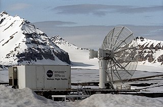
The Poker Flat Research Range (PFRR) is a launch facility and rocket range for sounding rockets in the U.S. state of Alaska, located on a 5,132-acre (20.77 km2) site at Chatanika, about 30 miles (50 km) northeast of Fairbanks and 1.5 degrees south of the Arctic Circle. More than 1,700 launches have been conducted at the range to study the Earth's atmosphere and the interaction between the atmosphere and the space environment. Areas studied at PFRR include the aurora, plasma physics, the ozone layer, solar proton events, Earth's magnetic field, and ultraviolet radiation. Rockets launched at PFRR have attained an apogee of 930 miles (1,500 km).

<span class="mw-page-title-main">Troll (research station)</span> Antarctic base

Troll is a Norwegian research station located at Jutulsessen, 235 kilometres (146 mi) from the coast in the eastern part of Princess Martha Coast in Queen Maud Land, Antarctica. It is Norway's only all-year research station in Antarctica, and is supplemented by the summer-only station Tor. Troll is operated by the Norwegian Polar Institute and also features facilities for the Norwegian Meteorological Institute and the Norwegian Institute for Air Research.

<span class="mw-page-title-main">Troll Airfield</span> Airstrip in Queen Maud Land, Antarctica

Troll Airfield is an airstrip located 6.8 kilometres (4.2 mi) from the research station Troll in Princess Martha Coast in Queen Maud Land, Antarctica. Owned and operated by the Norwegian Polar Institute, it consists of a 3,300-by-100-metre runway on glacial blue ice on the Antarctic ice sheet. The airport is located at 1,232 metres (4,042 ft) above mean sea level and is 235 kilometres (146 mi) from the coast.

Kongsberg Spacetec AS or KSPT or Spacetec A/S, is a supplier of space ground system solutions and services and is apart of Kongsberg Defence & Aerospace's Space & Surveillance division. The department of ground stations is based in Tromsø, Norway. The company is co-located with Kongsberg Satellite Services (KSAT) and Tromsø Satellite Station (TSS).

Kongsberg Satellite Services AS (KSAT) is a Norwegian-based company. KSAT has the most extensive ground station network globally, and the world's largest ground station for support of polar orbiting satellites located at 78° North - Svalbard, Norway. They are a provider of ground network services and maritime monitoring services

The Near Earth Network provides orbital communications support for near-Earth orbiting customer platforms via various ground stations, operated by NASA and other space agencies. It uses a number of different dishes scattered around the globe. The antennas must be able to move fast for tracking of objects in low Earth orbit (LEO). The NEN and SN combined were previously referred to as the Spaceflight Tracking and Data Network (STDN).

<span class="mw-page-title-main">Economy of Svalbard</span>

The economy of Svalbard is dominated by coal mining, tourism and research. In 2007, there were 484 people working in the mining sector, 211 people working in the tourism sector and 111 people working in the education sector. The same year, mining gave a revenue of 2.008 billion kr, tourism NOK 317 million and research 142 million. In 2006, the average income for economically active people was NOK 494,700, or 23% higher than on the mainland. Almost all housing is owned by the various employers and institutions and rented to their employees; there are only a few privately owned houses, most of which are recreational cabins. Because of this, it is nearly impossible to live on Svalbard without working for an established institution. The Spitsbergen Treaty and Svalbard Act established Svalbard as an economic free zone and demilitarized zone in 1925.

<span class="mw-page-title-main">Jutulsessen</span> Mountain of Antarctica

Jutulsessen is a nunatak in the Gjelsvik Mountains in Queen Maud Land, Antarctica. It is located in Princess Martha Coast, 235 kilometers (146 mi) from the King Haakon VII Sea. Jutulsessen is the site of the Norwegian research station Troll and the affiliated Troll Satellite Station, which has two radomes on top of the mountain. Troll Airfield is located in the vicinity.

<span class="mw-page-title-main">AISSat-1</span> Norwegian space satellite

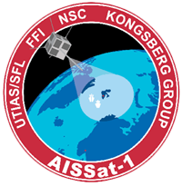
AISSat-1 is a satellite used to receive Automatic Identification System (AIS) signals. Launched on 12 June 2010 from Satish Dhawan Space Center as a secondary payload, AISSat-1 is in a sun-synchronous low Earth orbit. Initially a development project, the satellite has since passed into ordinary operations. Via downlinks at Svalbard Satellite Station and at Vardø Vessel Traffic Service Centre it tracks vessels in the Norwegian Sea and Barents Sea for the Norwegian Coastal Administration, the Norwegian Coast Guard, the Norwegian Directorate of Fisheries and other public agencies.

<span class="mw-page-title-main">Andøya Space</span> Norwegian space

Andøya Space, also named Andøya Space Center and formerly Andøya Rocket Range, is a rocket launch site, rocket range, and spaceport on Andøya island in Andøy Municipality in Nordland county, Norway. Since 1962, over 1,200 sounding and sub-orbital rockets of various configurations have been launched from the site.

<span class="mw-page-title-main">Isfjord Radio</span> Radio station in Svalbard, Norway

Isfjord Radio is a coast radio station, weather station and hotel located at Kapp Linné on the island Spitsbergen in Svalbard, Norway. The station was established in 1933, and has played an important role in the telecommunications between the Svalbard archipelago and the outside world. The station was destroyed by both sides during World War II, and rebuilt in 1946. The station was important for ships traffic and air traffic. Satellite communications were established in 1979, but deprecated when a fiber optic cable between Svalbard and the mainland was finished in 2004. Isfjord Radio was automated and depopulated in 1999. Parts of the outdated installations have been preserved as a historical site.

<span class="mw-page-title-main">Kongsfjord Telemetry Station</span> Earth station in Svalbard, Norway

Kongsfjord Telemetry Station was a satellite ground station located nearby Ny-Ålesund in Svalbard, Norway. It was used between 1967 and 1974 as one of the four initial ground stations which were part of the European Space Tracking Network (ESTRACK) serving the European Space Research Organization's (ESRO) first generation of satellites. The station provided radio tracking, telemetry and commanding services as well as data download. Although owned by ESRO, the facilities were constructed and operated by the Royal Norwegian Council for Scientific and Industrial Research (NTNF).

<span class="mw-page-title-main">Svalbard Satellite Station</span> Satellite ground station on Spitsbergen, Svalbard, Norway

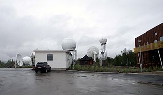
Svalbard Satellite Station or SvalSat is a satellite ground station located on Platåberget near Longyearbyen in Svalbard, Norway. Opened in 1997, it is operated by Kongsberg Satellite Services (KSAT), a joint venture between Kongsberg Defence & Aerospace and the Norwegian Space Centre (NSC). SvalSat and KSAT's Troll Satellite Station (TrollSat) in Antarctica are the only ground stations that can see a low altitude polar orbiting satellite on every revolution as the earth rotates. As of December 2019 the facility consists of almost 100 multi-mission and customer-dedicated antennas which operate in the C, L, S, X and K bands. The station provides ground services to more satellites than any other facility in the world.

<span class="mw-page-title-main">Tromsø Satellite Station</span> Satellite earth station in Tromsø, Norway

Tromsø Satellite Station, until 1988 known as Tromsø Telemetry Station, is a satellite earth station located in Tromsø, Norway. The facility is owned by Kongsberg Satellite Services (KSAT), a joint venture between the Kongsberg Group and the Norwegian Space Centre (NSC). In addition to hosting its own antennas serving thirty satellites, TSS acts as the center-point of KSAT's operations and provides backbone services for the high Arctic Svalbard Satellite Station (SvalSat) and the Antarctic Troll Satellite Station (TrollSat).

<span class="mw-page-title-main">LunIR</span> Spacecraft

LunIR is a nanosatellite spacecraft launched to the Moon collecting surface spectroscopy and thermography. It was launched as a secondary payload on the Artemis 1 mission on 16 November 2022.

References

  1. 1 2 3 4 Kyvik (2008): 153
  2. Rubin (2008): 305
  3. Wormdal (2011): 109
  4. Wormdal (2011): 38
  5. Wormdal (2011): 40
  6. Wormdal (2011): 41
  7. "Delplan for Svalbard Satellittstasjon (SvalSat), Platåberget" (in Norwegian). Kongsberg Satellite Services. 12 October 2005. Archived from the original on 12 April 2012. Retrieved 12 April 2012.
  8. Kyvik (2008): 154
  9. Wormdal (2011): 110
  10. 1 2 "Trollsat to Serve Antarctica". 20 April 2007. Archived from the original on 29 September 2012. Retrieved 29 September 2012.
  11. Molde, Eivind; Aune, Oddvin (20 January 2008). "Stoltenberg bor i telt i Antarktis". Norwegian Broadcasting Corporation. Archived from the original on 3 March 2016. Retrieved 29 September 2012.
  12. 1 2 "About Us". Kongsberg Satellite Services. Archived from the original on 11 February 2012. Retrieved 11 April 2012.
  13. Tonstad, Per Lars (22 February 2011). "Nye data hvert 30. minutt: Overvåker miljøet med satelitter". Teknisk Ukeblad (in Norwegian). Archived from the original on 12 April 2012. Retrieved 12 April 2012.
  14. Grønli, Kristin Straumsheim (13 December 2006). "Øyet i himmelen laster ned på Svalbard". Forskning.no (in Norwegian). Archived from the original on 3 December 2011. Retrieved 14 March 2012.
  15. 1 2 "Troll Satellite Station (TrollSat) – Antarctica". Kongsberg Satellite Services. Archived from the original on 7 July 2010. Retrieved 4 October 2010.
  16. Skatteboe, R.; Kjeldsen, A. A. (2004). "Interoperability reduces cost and risk at Svalbard Satellite Station" (PDF). American Institute of Aeronautics and Astronautics. Archived from the original (PDF) on 16 January 2011. Retrieved 16 January 2011.
  17. Wormdal (2011): 13
  18. "Galileo station in Antarctica". Norwegian Space Center. Archived from the original on 7 July 2010. Retrieved 4 October 2010.
  19. 1 2 Solholm, Rolleiv (2 January 2008). "Prime Minister opens new Antarctic satellite station". The Norway Post. Norwegian Broadcasting Corporation. Archived from the original on 7 July 2010. Retrieved 4 October 2010.
  20. "Galileo takes its place on top of the world". Kongsberg Satellite Services. 20 May 2011. Archived from the original on 12 May 2013. Retrieved 13 April 2012.
  21. "Troll i ord – ord om Troll" (in Norwegian). Norwegian Polar Institute. Archived from the original on 5 April 2008. Retrieved 4 October 2010.
  22. Hustadnes, John. "Troll". Archived from the original on 7 July 2010. Retrieved 4 October 2010.

Bibliography