The Earth Observing System (EOS) is a program of NASA comprising a series of artificial satellite missions and scientific instruments in Earth orbit designed for long-term global observations of the land surface, biosphere, atmosphere, and oceans. Since the early 1970s, NASA has been developing its Earth Observing System, launching a series of Landsat satellites in the decade. Some of the first included passive microwave imaging in 1972 through the Nimbus 5 satellite. Following the launch of various satellite missions, the conception of the program began in the late 1980s and expanded rapidly through the 1990s. Since the inception of the program, it has continued to develop, including; land, sea, radiation and atmosphere. Collected in a system known as EOSDIS, NASA uses this data in order to study the progression and changes in the biosphere of Earth. The main focus of this data collection surrounds climatic science. The program is the centrepiece of NASA's Earth Science Enterprise.
Mary Louise Cleave is an American engineer and a former NASA astronaut. She also served from 2005 to 2007 as NASA Associate Administrator for the Science Mission Directorate.

Jason-1 was a satellite altimeter oceanography mission. It sought to monitor global ocean circulation, study the ties between the ocean and the atmosphere, improve global climate forecasts and predictions, and monitor events such as El Niño and ocean eddies. Jason-1 was launched in 2001 and it was followed by OSTM/Jason-2 in 2008, and Jason-3 in 2016 – the Jason satellite series. Jason-1 was launched alongside the TIMED spacecraft.

The Goddard Institute for Space Studies (GISS) is a laboratory in the Earth Sciences Division of NASA's Goddard Space Flight Center affiliated with the Columbia University Earth Institute. The institute is located at Columbia University in New York City. It was named after Robert H. Goddard, American engineer, professor, physicist and inventor who is credited with creating and building the world's first liquid-fueled rocket.
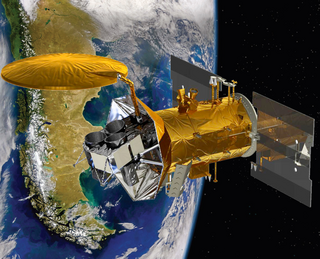
SeaWIFS was a satellite-borne sensor designed to collect global ocean biological data. Active from September 1997 to December 2010, its primary mission was to quantify chlorophyll produced by marine phytoplankton.

TOPEX/Poseidon was a joint satellite altimeter mission between NASA, the U.S. space agency; and CNES, the French space agency, to map ocean surface topography. Launched on August 10, 1992, it was the first major oceanographic research satellite. TOPEX/Poseidon helped revolutionize oceanography by providing data previously impossible to obtain. Oceanographer Walter Munk described TOPEX/Poseidon as "the most successful ocean experiment of all time." A malfunction ended normal satellite operations in January 2006.

Ocean color is the branch of ocean optics that specifically studies the color of the water and information that can be gained from looking at variations in color. The color of the ocean, while mainly blue, actually varies from blue to green or even yellow, brown or red in some cases. This field of study developed alongside water remote sensing, so it is focused mainly on how color is measured by instruments.
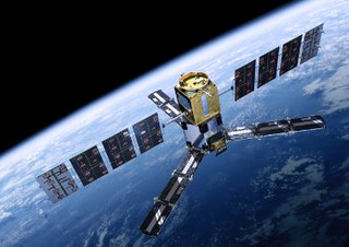
Aquarius was a NASA instrument aboard the Argentine SAC-D spacecraft. Its mission was to measure global sea surface salinity to better predict future climate conditions.

OSTM/Jason-2, or Ocean Surface Topography Mission/Jason-2 satellite, was an international Earth observation satellite altimeter joint mission for sea surface height measurements between NASA and CNES. It was the third satellite in a series started in 1992 by the NASA/CNES TOPEX/Poseidon mission and continued by the NASA/CNES Jason-1 mission launched in 2001.
Soil Moisture and Ocean Salinity (SMOS) is a satellite which forms part of ESA's Living Planet Programme. It is intended to provide new insights into Earth's water cycle and climate. In addition, it is intended to provide improved weather forecasting and monitoring of snow and ice accumulation.
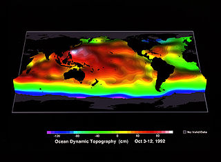
Ocean surface topography or sea surface topography, also called ocean dynamic topography, are highs and lows on the ocean surface, similar to the hills and valleys of Earth's land surface depicted on a topographic map. These variations are expressed in terms of average sea surface height (SSH) relative to Earth's geoid. The main purpose of measuring ocean surface topography is to understand the large-scale ocean circulation.

Goddard Space Flight Center is NASA's first, and oldest, space center. It is named after Robert H. Goddard, the father of modern rocketry. Throughout its history, the center has managed, developed, and operated many notable missions, including the Cosmic Background Explorer, the Hubble Space Telescope, the Tracking and Data Relay Satellite System (TDRSS), the Lunar Reconnaissance Orbiter, and the Solar Dynamics Observatory.

SAC-D, also known as Aquarius after its primary instrument, is an Argentine Earth science satellite built by INVAP and operated by CONAE. SAC-D was launched from Vandenberg Air Force Base on 10 June 2011, with a planned mission life of five years. Due to a power system failure, the mission was ended on 8 June 2015.

James Raymond Talacek is an American professional aquanaut with the University of North Carolina Wilmington (UNCW). He serves as Oceanographic Field Operations Manager at Aquarius Reef Base, the world's only undersea research laboratory.

Mark Whitney Hulsbeck is an American professional aquanaut. He serves as an Oceanographic Operations Field Manager and research diver for the Aquarius Reef Base, the world's only undersea research laboratory, operated by Florida International University. Hulsbeck is nicknamed "Otter".

Plankton, Aerosol, Cloud, ocean Ecosystem (PACE) is a NASA Earth-observing satellite mission that will continue and advance observations of global ocean color, biogeochemistry, and ecology, as well as the carbon cycle, aerosols and clouds. PACE will be used to identify the extent and duration of phytoplankton blooms and improve understanding of air quality. These and other uses of PACE data will benefit the economy and society, especially sectors that rely on water quality, fisheries and food security.

Claire Lucille Parkinson is an American Earth scientist and climatologist at NASA's Goddard Space Flight Center.
Paula Susan Bontempi is an oceanographer who has led the use of satellites in marine science during her positions in NASA and as the dean of the Graduate School of Oceanography at the University of Rhode Island.

The SeaWiFS Bio-optical Archive and Storage System (SeaBASS) is a data archive of in situ oceanographic data used to support satellite remote sensing research of ocean color. SeaBASS is used for developing algorithms for satellite-derived variables and for validating or “ground-truthing” satellite-derived data products. The acronym begins with “S” for SeaWiFS, because the data repository began in the 1990s around the time of the launch of the SeaWiFS satellite sensor, and the same data archive has been used ever since. Oceanography projects funded by the NASA Earth Science program are required to upload data collected on research campaigns to the SeaBASS data repository to increase the volume of open-access data available to the public. As of 2021 the data archive contained information from thousands of field campaigns uploaded by over 100 principal investigators.