An Earth observation satellite or Earth remote sensing satellite is a satellite used or designed for Earth observation (EO) from orbit, including spy satellites and similar ones intended for non-military uses such as environmental monitoring, meteorology, cartography and others. The most common type are Earth imaging satellites, that take satellite images, analogous to aerial photographs; some EO satellites may perform remote sensing without forming pictures, such as in GNSS radio occultation.
The Disaster Monitoring Constellation for International Imaging (DMCii) or just Disaster Monitoring Constellation (DMC) consists of a number of remote sensing satellites constructed by Surrey Satellite Technology Ltd (SSTL) and operated for the Algerian, Nigerian, Turkish, British and Chinese governments by DMC International Imaging. The DMC provides emergency Earth imaging for disaster relief under the International Charter for Space and Major Disasters, which the DMC formally joined in November 2005. Other DMC Earth imagery is used for a variety of civil applications by a variety of governments. Spare available imaging capacity is sold under contract.
EgyptSat 1 or MisrSat-1 was Egypt's first Earth remote sensing satellite. This satellite was jointly built by Egypt's National Authority for Remote Sensing and Space Sciences together with the Yuzhnoye Design Bureau in Ukraine and was launched on board a Dnepr rocket on 17 April 2007 from the Baikonur Cosmodrome.

Oceansat-2 is the second Indian satellite built primarily for ocean applications. It was a part of the Indian Remote Sensing Programme satellite series. Oceansat-2 is an Indian satellite designed to provide service continuity for operational users of the Ocean Colour Monitor (OCM) instrument on Oceansat-1. It will also enhance the potential of applications in other areas. The OceanSat-2 mission was approved by the government of India on 16 July 2005.
STUDSAT, is a CubeSat satellite designed by students. This project was conceptualised and project managed by undergraduate students across India. STUDSAT is a picosatellite successfully launched on 12 July 2010 from Satish Dhawan Space Centre into a Sun-synchronous orbit. The mission's objective was for students to have a hands-on experience with the design, fabrication and realisation of a space mission at a minimum cost. Experimental in nature, the mission life was stated to be six months.
ITUpSAT1, short for Istanbul Technical University picoSatellite-1, is a single CubeSat built by the Faculty of Aeronautics and Astronautics at the Istanbul Technical University. It was launched on 23 September 2009 atop a PSLV-C14 satellite launch vehicle from Satish Dhawan Space Centre, Sriharikota, Andhra Pradesh in India, and became the first Turkish university satellite to orbit the Earth. It was expected to have a minimum of six-month life term, but it is still functioning for over two years. It is a picosatellite with side lengths of 10 centimetres (3.9 in) and a mass of 0.990 kilograms (2.18 lb).

RAX-2 is a CubeSat satellite built as a collaboration between SRI International and students at the University of Michigan College of Engineering. It is the second spacecraft in the RAX mission. The RAX-1 mission ended after approximately two months of operation due to a gradual degradation of the solar panels that ultimately resulted in a loss of power. RAX team members applied the lessons learned from RAX-1 to the design of a second flight unit, RAX-2, which performs the same mission concept of RAX-1 with improved bus performance and additional operational modes. Science measurements are enhanced through interactive experiments with high power ionospheric heaters where FAI will be generated on demand.

The Mohammed Bin Rashid Space Center "MBRSC is a Dubai Government organisation, working on the UAE space program which includes various space satellites projects, such as the Emirates Mars Mission, the Emirates Lunar Mission, and the UAE astronaut program. The center actively works to promote space science and research in the region and encompasses the Emirates Institution for Advanced Science and Technology (EIAST).

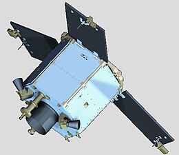
DubaiSat-2 is an electro-optical Earth observation satellite built by the Mohammed bin Rashid Space Centre (MBRSC) under an agreement with Satrec Initiative, a satellite manufacturing company in South Korea. MBRSC's objective with DubaiSat-2 is to provide electro-optical images, that can be commercialized, for users within the United Arab Emirates and beyond and to develop and implement new technologies not used in DubaiSat-1. MBRSC also intends to continue manpower training for the UAE's space program. 16 UAE engineers have been working on the design, development, testing and manufacturing of the satellite. The participation of the UAE engineers, who are currently working in South Korea, has increased by 100 percent from the DubaiSat-1 project.

A ground segment consists of all the ground-based elements of a space system used by operators and support personnel, as opposed to the space segment and user segment. The ground segment enables management of a spacecraft, and distribution of payload data and telemetry among interested parties on the ground. The primary elements of a ground segment are:

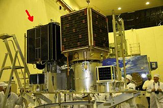
KhalifaSat, is a remote sensing Earth observation satellite that was designed and built at the Space Technology Laboratories of the Mohammed bin Rashid Space Centre in Dubai. It is considered the first entirely Emirati-made satellite. It launched into orbit on 30 October 2018 from Japan's Tanegashima Space Center using the Korean Satrec SI-300 bus.

The UAE Space Agency (UAESA) is the space agency of the United Arab Emirates government responsible for the development of the country's space industry. It was created in 2014 and is responsible for developing and regulating the space sector in the UAE.
Omran Sharaf is an Emirati engineer and the project manager of the first Emirates Mars Mission. He is also the director of the programs management department at the Mohammed bin Rashid Space Centre, a United Arab Emirates Space Agency.

Gaofen is a series of Chinese high-resolution Earth imaging satellites launched as part of the China High-resolution Earth Observation System (CHEOS) program. CHEOS is a state-sponsored, civilian Earth-observation program used for agricultural, disaster, resource, and environmental monitoring. Proposed in 2006 and approved in 2010, the CHEOS program consists of the Gaofen series of space-based satellites, near-space and airborne systems such as airships and UAVs, ground systems that conduct data receipt, processing, calibration, and taskings, and a system of applications that fuse observation data with other sources to produce usable information and knowledge.
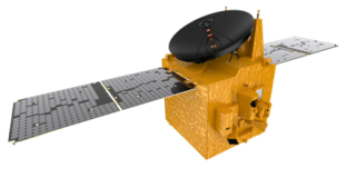
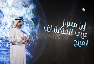
The Emirates Mars Mission is a United Arab Emirates Space Agency uncrewed space exploration mission to Mars. The Hope probe was launched on 20 July 2020, and went into orbit around Mars on 9 February 2021.
The National Space Program (PSN) horizons 2020 planned to put in place space infrastructures, and space systems and increase the specialized human resources in space technologies. Among the space systems planned in the PSN are Algeria's satellites, of which a significant number should be partly or totally integrated into the Algerian center for satellite development "CDS". CDS offers the technological environment for national competence to develop the future Algerian satellite systems. Algeria's objective is to make space tools a powerful instrument in national prosperity in the fields of earth observation, meteorology and communications.

Satrec Initiative Co., Ltd. or SI is a South Korean satellite manufacturing company headquartered in Daejeon, South Korea The company was founded in 1999 by the engineers who developed the first Korean satellite (KITSAT-1) at KAIST SaTRec. The company designs and builds Earth observation satellites called SpaceEye-series, and it provides various space components, including high resolution electro-optical payloads and star-trackers. SI's first satellite was a Malaysian Earth observation satellite, RazakSAT launched in 2009. SI has two subsidiaries: SI Imaging Services (SIIS) is the exclusive image data provider of KOMPSAT-series, and SI Analytics (SIA) provides AI-native GEOINT solutions for satellite imagery. SI also spun-off SI Detection (SID), which provides radiation monitoring solutions.

OPTOS was a Spanish nanosatellite designed and developed by INTA with support from the European Cooperation for Space Standardization (ECSS) as a low-cost technology demonstrator. It was launched in 2013 and had a service life of three years.

The Emirates Lunar Mission was the first mission to the Moon from the United Arab Emirates.
EOS SAT-1 is an optical Earth observation satellite for agricultural land monitoring by EOS Data Analytics, Inc., a global AI-powered satellite imagery analytics provider. The space optics instrument and satellite manufacturer Dragonfly Aerospace built the satellite and equipped it with two high-resolution DragonEye cameras.