NOAA-19

Last updated

NOAA-19
NOAA-N' satellite in Vandenberg AFB clean room.jpg
NOAA-19 before launch
NamesNOAA-N'
NOAA-N Prime
Mission type Weather
Operator NOAA
COSPAR ID 2009-005A OOjs UI icon edit-ltr-progressive.svg
SATCAT no. 33591
Mission duration2 years (planned) [1]
14 years, 10 months, 16 days (elapsed)
Spacecraft properties
Spacecraft type TIROS
Bus Advanced TIROS-N
Manufacturer Lockheed Martin
Launch mass1,440 kg (3,170 lb) [2]
Dimensions4.19 m (13.7 ft) of long
1.88 m (6 ft 2 in) of diameter
Start of mission
Launch date6 February 2009,
10:22:00 UTC [3]
Rocket Delta II 7320-10C
(Delta D338) [4]
Launch site Vandenberg, SLC-2W
Contractor United Launch Alliance
Entered service6 June 2009 [5]
Orbital parameters
Reference system Geocentric orbit [6]
Regime Sun-synchronous orbit
Perigee altitude 846 km (526 mi)
Apogee altitude 866 km (538 mi)
Inclination 98.70°
Period 102.00 minutes
  NOAA-18
Suomi NPP  
 

NOAA-19, [7] known as NOAA-N' (NOAA-N Prime) before launch, is the last of the American National Oceanic and Atmospheric Administration (NOAA) series of weather satellites. NOAA-19 was launched on 6 February 2009. NOAA-19 is in an afternoon Sun-synchronous orbit and is intended to replace NOAA-18 as the prime afternoon spacecraft. [8]

Contents

Launch

On 4 November 2008, NASA announced that the satellite had arrived at Vandenberg aboard a Lockheed C-5 Galaxy military transport aircraft. [9] Installation of the payload fairing took place 27 January 2009; second stage propellant was loaded on 31 January 2009. [10]

Several attempts were made to conduct the launch. [11] [12] The first attempt, 4 February 2009, was scrubbed after a failure was detected in a launch pad gaseous nitrogen pressurization system. The second attempt, 5 February 2009, was scrubbed after the failure of a payload fairing air conditioning compressor, which is also part of the ground support equipment at the launch pad.

The satellite was successfully launched at 10:22 UTC on 6 February 2009 [13] aboard a Delta II flying in the 7320-10C configuration from Vandenberg Air Force Base (VAFB).

Instruments

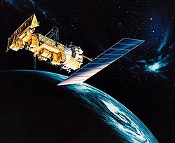
NOAA-N Prime carries a suite of eight instruments that provides data for weather and climate predictions. Like its predecessors, NOAA-N Prime provides global images of clouds and surface features and vertical profiles of atmospheric temperature and humidity for use in numerical weather and ocean forecast models, as well as data on ozone distribution in the upper part of the atmosphere, and near-Earth space environments — information important for the marine, aviation, power generation, agriculture, and other communities. The NOAA-N Prime primary instruments — the Advanced Very High Resolution Radiometer (AVHRR/3), High Resolution Infrared Radiation Sounder (HIRS/4), and the Advanced Microwave Sounding Unit (AMSU-A) — were all designed for a three-year mission. The Space Environment Monitor (SEM/2) is fitted to the satellite and is composed of Total Energy Detector (TED) and MEPED (Medium Energy Proton and Electron Detector). The Solar Backscatter Ultraviolet Spectral Radiometer (SBUV/2) was designed for a two-year mission, and the Microwave Humidity Sounder (MHS) instrument was designed for a five-year mission. [14] NOAA-19 also hosts Cospas-Sarsat payloads. [15]

Advanced Very High Resolution Radiometer (AVHRR/3)

The Advanced Very High Resolution Radiometer/3 (AVHRR/3) is the primary imaging system and consists of visible, near infrared (IR) and thermal IR channels. The AVHRR, built by ITT, observes vegetation, clouds, and the surface of bodies of water, shorelines, snow, aerosols and ice. The instrument has a scan mirror that continuously rotates and scans the Earth at six revolutions per second to provide continuous coverage. [16]

Solar Backscatter Ultraviolet Radiometer (SBUV/2)

The Solar Backscatter Ultraviolet Radiometer/2 (SBUV/2) instrument is both an imager and a sounder. As an imager, it produces total column ozone maps. As a sounder, it obtains and measures the ozone distribution in the atmosphere as a function of altitude. The SBUV, built by Ball Aerospace, is a long-term monitoring device that takes global measurements and observes how elements in the atmosphere change over time. Each channel on the nadir-pointing SBUV detects a particular near-ultraviolet wavelength whose intensity depends on the ozone density at a particular height in the atmosphere. The SBUV includes a Cloud Cover Radiometer that provides information on the amount of cloud cover in an image and removes the effects of the clouds from the data. [17]

Microwave Humidity Sounder (MHS)

The Microwave Humidity Sounder (MHS), built by EADS Astrium and donated by the European Organisation for the Exploitation of Meteorological Satellites (EUMETSAT), is a five-channel microwave instrument intended primarily to measure profiles of atmospheric humidity. [18]

High Resolution Infrared Radiation Sounder (HIRS/4)

HIRS/4, built by ITT, has 19 infrared channels and one visible channel. The instrument principally measures carbon dioxide, water and ozone. These measurements allow scientists to determine the amount of each of these gases in the atmosphere and the altitude at which they appear. [19]

Advanced Microwave Sounding Unit (AMSU-A)

AMSU-A, built by Northrop Grumman, has 15 channels and continuously scans the Earth's surface and the atmosphere, measuring naturally emitted microwave signals radiated by the Earth's surface and atmosphere. [20]

Space Environment Monitor (SEM-2)

The Space Environment Monitor (SEM-2) was built by Panametrics, now Assurance Technology Corporation. It provides measurements to determine the intensity of the Earth's radiation belts and the flux of charged particles at satellite altitude. The SEM-2 consists of two separate sensor units and a common Data Processing Unit (DPU). The sensor units are the Total Energy Detector (TED) and the Medium Energy Proton and Electron Detector (MEPED). [21]

Advanced Data Collection System (ADCS)

The Advanced Data Collection System (ADCS), provided by CNES in France, measures environmental factors such as atmospheric temperature and pressure and the velocity and direction of ocean and wind currents. Data is collected from various transmitting devices on platforms (e.g., buoys, free-floating balloons and remote weather stations). Transmitters are even placed on migratory animals, sea turtles, bears, and other animals. Data is transmitted to the spacecraft for storage and subsequent transmission from the satellite to the ground. The stored data is transmitted once per orbit. [22]

SARSAT

The Search And Rescue Satellite-Aided Tracking (SARSAT) system. The Search and Rescue Repeater (SARR), built by the Department of National Defense in Canada, and the Search and Rescue Processor (SARP), built by Centre National d'Études Spatiales (CNES), detect distress calls sent from emergency beacons on-board aircraft and boats and carried by people in remote areas. The instruments on the spacecraft transmit the data to ground receiving stations or local user terminals where the location of the emergency signals is determined by Doppler processing. [15]

Damage during manufacture

NOAA-N Prime after falling over during construction, on 6 September 2003. NOAA-N' accident.jpg
NOAA-N Prime after falling over during construction, on 6 September 2003.

On 6 September 2003 at 15:28 UTC, the satellite was badly damaged while being worked on at the Lockheed Martin Space Systems factory in Sunnyvale, California. The spacecraft fell to the floor as it reached 13° of tilt while being rotated. The satellite fell as a team was turning it from a vertical to a horizontal position. A NASA inquiry into the mishap determined that it was caused by a lack of procedural discipline throughout the facility. While the turn-over cart used during the procedure was in storage, a technician removed twenty-four bolts securing an adapter plate to it without documenting the action. The team subsequently using the cart to turn the satellite failed to check the bolts, as specified in the procedure, before attempting to move the satellite. [23] [24] Repairs to the satellite cost US$135 million. Lockheed Martin agreed to forfeit all profit from the project to help pay for repair costs; they later took a US$30 million charge relating to the incident. The remainder of the repair costs were paid by the United States government. [25]

Replacement

The NOAA series was scheduled to be replaced by a next-generation NPOESS series before that project was cancelled. Instead Suomi NPP was launched in 2011 as a bridge to the Joint Polar Satellite System (JPSS). The first JPSS satellite was launched in 2017.

Related Research Articles

<span class="mw-page-title-main">Advanced microwave sounding unit</span> Instrument installed on meteorological satellites

The advanced microwave sounding unit (AMSU) is a multi-channel microwave radiometer installed on meteorological satellites. The instrument examines several bands of microwave radiation from the atmosphere to perform atmospheric sounding of temperature and moisture levels.

<span class="mw-page-title-main">NOAA-17</span>

NOAA-17, also known as NOAA-M before launch, was an operational, polar orbiting, weather satellite series operated by the National Environmental Satellite Service (NESS) of the National Oceanic and Atmospheric Administration (NOAA). NOAA-17 also continued the series of Advanced TIROS-N (ATN) spacecraft begun with the launch of NOAA-8 (NOAA-E) in 1983 but with additional new and improved instrumentation over the NOAA A-L series and a new launch vehicle.

<span class="mw-page-title-main">NOAA-16</span>

NOAA-16, also known as NOAA-L before launch, was an operational, polar orbiting, weather satellite series operated by the National Environmental Satellite Service (NESS) of the National Oceanic and Atmospheric Administration (NOAA). NOAA-16 continued the series of Advanced TIROS-N (ATN) spacecraft that began with the launch of NOAA-8 (NOAA-E) in 1983; but it had additional new and improved instrumentation over the NOAA A-K series and a new launch vehicle. It was launched on 21 September 2000 and, following an unknown anomaly, it was decommissioned on 9 June 2014. In November of 2015 it broke up in orbit, creating more than 200 pieces of debris.

<span class="mw-page-title-main">NOAA-18</span>

NOAA-18, also known as NOAA-N before launch, is an operational, polar orbiting, weather satellite series operated by the National Environmental Satellite Service (NESS) of the National Oceanic and Atmospheric Administration (NOAA). NOAA-18 also continued the series of Advanced TIROS-N (ATN) spacecraft begun with the launch of NOAA-8 (NOAA-E) in 1983 but with additional new and improved instrumentation over the NOAA A-M series and a new launch vehicle. NOAA-18 is in an afternoon equator-crossing orbit and replaced NOAA-17 as the prime afternoon spacecraft.

<span class="mw-page-title-main">NOAA-15</span>

NOAA-15, also known as NOAA-K before launch, is an operational, polar-orbiting of the NASA-provided Television Infrared Observation Satellite (TIROS) series of weather forecasting satellite operated by National Oceanic and Atmospheric Administration (NOAA). NOAA-15 was the latest in the Advanced TIROS-N (ATN) series. It provided support to environmental monitoring by complementing the NOAA/NESS Geostationary Operational Environmental Satellite program (GOES).

The Polar-orbiting Operational Environmental Satellite (POES), often confused with the South African slang term poes, is a constellation of polar orbiting weather satellites funded by the National Oceanic and Atmospheric Administration (NOAA) and the European Organisation for the Exploitation of Meteorological Satellites (EUMETSAT) with the intent of improving the accuracy and detail of weather analysis and forecasting. The spacecraft were provided by NASA and the European Space Agency (ESA), and NASA's Goddard Space Flight Center oversaw the manufacture, integration and test of the NASA-provided TIROS satellites. The first polar-orbiting weather satellite launched as part of the POES constellation was the Television Infrared Observation Satellite-N (TIROS-N), which was launched on 13 October 1978. The final spacecraft, NOAA-19, was launched on 6 February 2009. The ESA-provided MetOp satellite operated by EUMETSAT utilize POES-heritage instruments for the purpose of data continuity. The Joint Polar Satellite System, which was launched on 18 November 2017, is the successor to the POES Program.

NOAA-13, also known as NOAA-I before launch, was an American weather satellite operated by the National Oceanic and Atmospheric Administration (NOAA). NOAA-I continued the operational, polar orbiting, meteorological satellite series operated by the National Environmental Satellite System (NESS) of the National Oceanic and Atmospheric Administration (NOAA). NOAA-I continued the series (fifth) of Advanced TIROS-N (ATN) spacecraft begun with the launch of NOAA-8 (NOAA-E) in 1983. NOAA-I was in an afternoon equator-crossing orbit and was intended to replace the NOAA-11 (NOAA-H) as the prime afternoon (14:00) spacecraft.

<span class="mw-page-title-main">NOAA-7</span>

NOAA-7, known as NOAA-C before launch, was an American operational weather satellite for use in the National Operational Environmental Satellite System (NOESS) and for the support of the Global Atmospheric Research Program (GARP) during 1978-1984. The satellite design provided an economical and stable Sun-synchronous platform for advanced operational instruments to measure the atmosphere of Earth, its surface and cloud cover, and the near-space environment. An earlier launch, NOAA-B, was scheduled to become NOAA-7, however NOAA-B failed to reach its required orbit.

NOAA-6, known as NOAA-A before launch, was an American operational weather satellite for use in the National Operational Environmental Satellite System (NOESS) and for the support of the Global Atmospheric Research Program (GARP) during 1978-1984. The satellite design provided an economical and stable Sun-synchronous platform for advanced operational instruments to measure the atmosphere of Earth, its surface and cloud cover, and the near-space environment.

NOAA B was an American operational weather satellite for use in the National Operational Environmental Satellite System (NOESS) and for the support of the Global Atmospheric Research Program (GARP) during 1978-1984. The satellite design provided an economical and stable Sun-synchronous platform for advanced operational instruments to measure the atmosphere of Earth, its surface and cloud cover, and the near-space environment.

<span class="mw-page-title-main">Joint Polar Satellite System</span> Constellation of American meteorology satellites

The Joint Polar Satellite System (JPSS) is the latest generation of U.S. polar-orbiting, non-geosynchronous, environmental satellites. JPSS will provide the global environmental data used in numerical weather prediction models for forecasts, and scientific data used for climate monitoring. JPSS will aid in fulfilling the mission of the U.S. National Oceanic and Atmospheric Administration (NOAA), an agency of the Department of Commerce. Data and imagery obtained from the JPSS will increase timeliness and accuracy of public warnings and forecasts of climate and weather events, thus reducing the potential loss of human life and property and advancing the national economy. The JPSS is developed by the National Aeronautics and Space Administration (NASA) for the National Oceanic and Atmospheric Administration (NOAA), who is responsible for operation of JPSS. Three to five satellites are planned for the JPSS constellation of satellites. JPSS satellites will be flown, and the scientific data from JPSS will be processed, by the JPSS – Common Ground System (JPSS-CGS).

<span class="mw-page-title-main">Suomi NPP</span>

The Suomi National Polar-orbiting Partnership, previously known as the National Polar-orbiting Operational Environmental Satellite System Preparatory Project (NPP) and NPP-Bridge, is a weather satellite operated by the United States National Oceanic and Atmospheric Administration (NOAA). It was launched in 2011 and is currently in operation.

<span class="mw-page-title-main">NOAA-21</span> NASA/NOAA satellite

NOAA-21, designated JPSS-2 prior to launch, is the second of the United States National Oceanic and Atmospheric Administration (NOAA)'s latest generation of U.S. polar-orbiting, non-geosynchronous, environmental satellites called the Joint Polar Satellite System. NOAA-21 was launched on 10 November 2022 and join NOAA-20 and Suomi NPP in the same orbit. Circling the Earth from pole-to-pole, it will cross the equator about 14 times daily, providing full global coverage twice a day. It was launched with LOFTID.

<span class="mw-page-title-main">NOAA-20</span> NASA satellite

NOAA-20, designated JPSS-1 prior to launch, is the first of the United States National Oceanic and Atmospheric Administration's latest generation of U.S. polar-orbiting, non-geosynchronous, environmental satellites called the Joint Polar Satellite System. NOAA-20 was launched on 18 November 2017 and joined the Suomi National Polar-orbiting Partnership satellite in the same orbit. NOAA-20 operates about 50 minutes behind Suomi NPP, allowing important overlap in observational coverage. Circling the Earth from pole-to-pole, it crosses the equator about 14 times daily, providing full global coverage twice a day. This gives meteorologists information on "atmospheric temperature and moisture, clouds, sea-surface temperature, ocean color, sea ice cover, volcanic ash, and fire detection" so as to enhance weather forecasting including hurricane tracking, post-hurricane recovery by detailing storm damage and mapping of power outages.

<span class="mw-page-title-main">NOAA-8</span> Weather satellite

NOAA-8, known as NOAA-E before launch, was an American weather satellite operated by the National Oceanic and Atmospheric Administration (NOAA) for use in the National Environmental Satellite Data and Information Service (NESDIS). It was first of the Advanced TIROS-N series of satellites. The satellite design provided an economical and stable Sun-synchronous platform for advanced operational instruments to measure the atmosphere of Earth, its surface and cloud cover, and the near-space environment.

<span class="mw-page-title-main">NOAA-9</span> American weather satellite

NOAA-9, known as NOAA-F before launch, was an American weather satellite operated by the National Oceanic and Atmospheric Administration (NOAA) for use in the National Environmental Satellite Data and Information Service (NESDIS). It was the second of the Advanced TIROS-N series of satellites. The satellite design provided an economical and stable Sun-synchronous platform for advanced operational instruments to measure the atmosphere of Earth, its surface and cloud cover, and the near-space environment.

NOAA-10, known as NOAA-G before launch, was an American weather satellite operated by the National Oceanic and Atmospheric Administration (NOAA) for use in the National Environmental Satellite Data and Information Service (NESDIS). It was the third of the Advanced TIROS-N series of satellites. The satellite design provided an economical and stable Sun-synchronous platform for advanced operational instruments to measure the atmosphere of Earth, its surface and cloud cover, and the near-space environment.

NOAA-11, known as NOAA-H before launch, was an American weather satellite operated by the National Oceanic and Atmospheric Administration (NOAA) for use in the National Operational Environmental Satellite System (NOESS) and for support of the Global Atmospheric Research Program (GARP) during 1978–1984. It was the fourth of the Advanced TIROS-N series of satellites. The satellite design provided an economical and stable Sun-synchronous platform for advanced operational instruments to measure the atmosphere of Earth, its surface and cloud cover, and the near-space environment.

NOAA-12, also known as NOAA-D before launch, was an American weather satellite operated by National Oceanic and Atmospheric Administration (NOAA), an operational meteorological satellite for use in the National Environmental Satellite, Data, and Information Service (NESDIS). The satellite design provided an economical and stable Sun-synchronous platform for advanced operational instruments to measure the atmosphere of Earth, its surface and cloud cover, and the near-space environment.

NOAA-14, also known as NOAA-J before launch, was an American weather satellite operated by the National Oceanic and Atmospheric Administration (NOAA). NOAA-14 continued the third-generation operational, Polar Orbiting Environmental Satellite (POES) series operated by the National Environmental Satellite Service (NESS) of the National Oceanic and Atmospheric Administration (NOAA). NOAA-14 continued the series of Advanced TIROS-N (ATN) spacecraft begun with the launch of NOAA-8 (NOAA-E) in 1983.

References

  1. Krebs, Gunter. "NOAA 18, 19 (NOAA N, N')". Gunter's Space Page. Retrieved 9 December 2013.
  2. "Display: NOAA 19 2009-005A". NASA. 14 May 2020. Retrieved 26 December 2020.PD-icon.svg This article incorporates text from this source, which is in the public domain .
  3. McDowell, Jonathan. "Launch Log". Jonathan's Space Report. Retrieved 9 December 2013.
  4. "NOAA-N Prime Mission Overview Booklet" (PDF). ulalaunch.com. United Launch Alliance. 2008. Archived from the original (PDF) on 4 March 2016. Retrieved 6 June 2015.
  5. "POES Operational Status". 22 March 2019. Retrieved 5 January 2021.
  6. "Trajectory: NOAA-19 2020-005A". NASA. 14 May 2020. Retrieved 26 December 2020.PD-icon.svg This article incorporates text from this source, which is in the public domain .
  7. "NOAA-N Prime Overview". NASA. Retrieved 6 February 2009.PD-icon.svg This article incorporates text from this source, which is in the public domain .
  8. "Display: NOAA-19 2009-005A". NASA. 14 May 2020. Retrieved 6 January 2021.PD-icon.svg This article incorporates text from this source, which is in the public domain .
  9. "NOAA-N Prime Satellite Arrives At Vandenberg For Launch". NASA. 4 November 2008.PD-icon.svg This article incorporates text from this source, which is in the public domain .
  10. "Expendable Launch Vehicle Status Report". NASA. 23 January 2009.PD-icon.svg This article incorporates text from this source, which is in the public domain .
  11. "NASA - NOAA-N Prime Satellite Launch Reset for February 5". nasa.gov. NASA. Retrieved 19 August 2017.
  12. "NASA - NOAA-N Prime Satellite Launch Rescheduled for Friday, February 6". nasa.gov. Retrieved 19 August 2017.PD-icon.svg This article incorporates text from this source, which is in the public domain .
  13. "NOAA-N Prime (NOAA-19) Satellite". NOAA. Archived from the original on 24 February 2015.PD-icon.svg This article incorporates text from this source, which is in the public domain .
  14. "NOAA-N Prime" (PDF). NP-2008-10-056-GSFC. NASA Goddard Space Flight Center. 16 December 2008. Archived from the original (PDF) on 16 February 2013. Retrieved 8 October 2010.PD-icon.svg This article incorporates text from this source, which is in the public domain .
  15. 1 2 "SARSAT 2009-005A". NASA. 14 May 2020. Retrieved 26 December 2020.PD-icon.svg This article incorporates text from this source, which is in the public domain .
  16. "AVHRR/3 2009-005A". NASA. 14 May 2020. Retrieved 26 December 2020.PD-icon.svg This article incorporates text from this source, which is in the public domain .
  17. "SBUV/2 2009-005A". NASA. 14 May 2020. Retrieved 26 December 2020.PD-icon.svg This article incorporates text from this source, which is in the public domain .
  18. "MHS 2009-005A". NASA. 14 May 2020. Retrieved 26 December 2020.PD-icon.svg This article incorporates text from this source, which is in the public domain .
  19. "HIRS/4 2009-005A". NASA. 14 May 2020. Retrieved 26 December 2020.PD-icon.svg This article incorporates text from this source, which is in the public domain .
  20. "AMSU-A 2009-005A". NASA. 14 May 2020. Retrieved 26 December 2020.PD-icon.svg This article incorporates text from this source, which is in the public domain .
  21. "SEM-2 2009-005A". NASA. 14 May 2020. Retrieved 26 December 2020.PD-icon.svg This article incorporates text from this source, which is in the public domain .
  22. "ADCS 2009-005A". NASA. 14 May 2020. Retrieved 26 December 2020.PD-icon.svg This article incorporates text from this source, which is in the public domain .
  23. "NOAA-N-Prime Satellite Mishap Investigation Report Released". SpaceRef. 4 October 2004. Retrieved 14 June 2012.[ permanent dead link ]
  24. "NOAA N-Prime Mishap Investigation Final Report" (PDF). Retrieved 12 November 2023.
  25. Bates, Jason (11 October 2004). "Lockheed Martin Profits To Pay for NOAA N-Prime Repairs". space.com. Retrieved 19 June 2016.