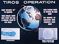
Television InfraRed Observation Satellite (TIROS) is a series of early weather satellites launched by the United States, beginning with TIROS-1 in 1960. TIROS was the first satellite that was capable of remote sensing of the Earth, enabling scientists to view the Earth from a new perspective: space. The program, promoted by Harry Wexler, proved the usefulness of satellite weather observation, at a time when military reconnaissance satellites were secretly in development or use. TIROS demonstrated at that time that "the key to genius is often simplicity". TIROS is an acronym of "Television InfraRed Observation Satellite" and is also the plural of "tiro" which means "a young soldier, a beginner".

NOAA-17, also known as NOAA-M before launch, was an operational, polar orbiting, weather satellite series operated by the National Environmental Satellite Service (NESS) of the National Oceanic and Atmospheric Administration (NOAA). NOAA-17 also continued the series of Advanced TIROS-N (ATN) spacecraft begun with the launch of NOAA-8 (NOAA-E) in 1983 but with additional new and improved instrumentation over the NOAA A-L series and a new launch vehicle.

NOAA-7, known as NOAA-C before launch, was an American operational weather satellite for use in the National Operational Environmental Satellite System (NOESS) and for the support of the Global Atmospheric Research Program (GARP) during 1978-1984. The satellite design provided an economical and stable Sun-synchronous platform for advanced operational instruments to measure the atmosphere of Earth, its surface and cloud cover, and the near-space environment. An earlier launch, NOAA-B, was scheduled to become NOAA-7, however NOAA-B failed to reach its required orbit.

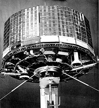
ESSA-1 was a spin-stabilized operational meteorological satellite. Its name was derived from that of its oversight agency, the Environmental Science Services Administration (ESSA).

ESSA-9, also known as TOS-G, was a meteorological satellite. Its name was derived from that of its oversight agency, the Environmental Science Services Administration (ESSA). ESSA-9 replaced the ESSA-7 satellite.
NOAA B was an American operational weather satellite for use in the National Operational Environmental Satellite System (NOESS) and for the support of the Global Atmospheric Research Program (GARP) during 1978-1984. The satellite design provided an economical and stable Sun-synchronous platform for advanced operational instruments to measure the atmosphere of Earth, its surface and cloud cover, and the near-space environment.

TIROS-3 was a spin-stabilized meteorological satellite. It was the third in a series of Television Infrared Observation Satellites.
TIROS-4 was a spin-stabilized meteorological satellite. It was the fourth in a series of Television Infrared Observation Satellites.

TIROS 5 was a spin-stabilized meteorological satellite. It was the fifth in a series of Television Infrared Observation Satellites.
TIROS 6 was a spin-stabilized meteorological satellite. It was the sixth in a series of Television Infrared Observation Satellites.

TIROS-7 was a spin-stabilized meteorological satellite. It was the seventh in a series of Television Infrared Observation Satellites.

TIROS-8 was a spin-stabilized meteorological satellite. It was the eighth in a series of Television Infrared Observation Satellites.

TIROS-9 was a spin-stabilized meteorological satellite. It was the ninth in a series of Television Infrared Observation Satellites.
TIROS-10 was a spin-stabilized meteorological satellite. It was the tenth and last in a series of Television Infrared Observation Satellites.

ESSA 3 was a spin-stabilized operational meteorological satellite. Its name was derived from that of its oversight agency, the Environmental Science Services Administration (ESSA).

Nimbus 5 was a meteorological satellite for the research and development of sensing technology. It was the fifth successful launch in a series of the Nimbus program.
Nimbus 6 was a meteorological satellite. It was the sixth in a series of the Nimbus program.

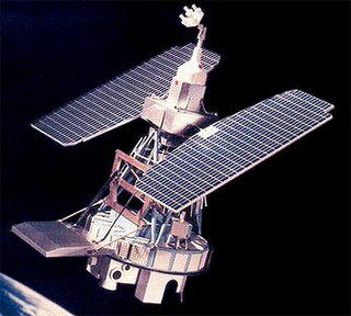
NOAA-1, also known as ITOS-A was a weather satellite operated by the National Oceanic and Atmospheric Administration (NOAA). It was part of a series of satellites called ITOS, or improved TIROS.

ITOS-B was a weather satellite operated by the National Oceanic and Atmospheric Administration (NOAA). It was part of a series of satellites called ITOS, or improved TIROS.

NOAA-5, also known as ITOS-H was a weather satellite operated by the National Oceanic and Atmospheric Administration (NOAA). It was part of a series of satellites called ITOS, or improved TIROS, being the last of the series. NOAA-5 was launched on a Delta rocket on July 29, 1976.