TIROS-1

Last updated

TIROS-1
Tiros satellite navitar.jpg
The TIROS-1 prototype on display at the Smithsonian National Air and Space Museum.
Mission type Weather satellite
Operator NASA [1]
Harvard designation1960 β 2
COSPAR ID 1960-002B OOjs UI icon edit-ltr-progressive.svg
SATCAT no. 29
Mission duration75 days (90 days planned)
Spacecraft properties
Spacecraft type TIROS
Manufacturer RCA Astro
Launch mass122.5 kilograms (270 lb)
Start of mission
Launch date1 April 1960, 11:40:09 (1960-04-01UTC11:40:09Z) GMT
Rocket Thor DM 18-Able II
Launch site Cape Canaveral, LC-17A
End of mission
Last contact15 June 1960 (1960-06-16)
Orbital parameters
Reference system Geocentric
Regime LEO
Eccentricity 0.00401
Perigee altitude 693 kilometres (431 mi)
Apogee altitude 750 kilometres (470 mi)
Inclination 48.40°
Period 99.16 minutes [2]
Epoch 1 Apr 1960 11:45:00
Instruments
two slow-scan visible television camera
(wide-angle and narrow-angle)
horizon sensor
sun angle sensor
TIROS-2  
 

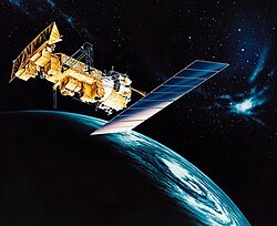
TIROS-1 (or TIROS-A) was the first full-scale weather satellite (the Vanguard 2 satellite was the first experimental/prototype weather satellite), the first of a series of Television Infrared Observation Satellites placed in low Earth orbit.

Contents

Program

The TIROS Program was NASA's first experimental step to determine if satellites could be useful in the study of the Earth. At that time, the effectiveness of satellite observations was still unproven. Since satellites were a new technology, the TIROS Program also tested various design issues for spacecraft: instruments, data and operational parameters. The goal was to improve satellite applications for Earth-bound decisions, such as "should we evacuate the coast because of the hurricane?". [1]

The TIROS-1 Program's first priority was the development of a meteorological satellite information system. Weather forecasting was deemed the most promising application of space-based observations. [1]

Spacecraft

TIROS 1 was an 18-sided right prism, 107 centimetres (42 in) across opposite corners and 56 centimetres (22 in) high. Spacecraft power was supplied by approximately 9000 1 centimetre (0.39 in)- by 2 centimetres (0.79 in) silicon solar cells mounted on the cover assembly and by 21 nickel-cadmium batteries. A single monopole antenna for reception of ground commands extended out from the top of the cover assembly. A pair of crossed-dipole antennas (235 MHz) for transmission projected down and diagonally out from the baseplate. Mounted around the edge of the baseplate were five diametrically opposed pairs of small, solid-fuel thrusters that maintained the satellite spin rate between 8 and 12 rpm. The satellite was equipped with two 1.27 centimetres (0.50 in)-diameter vidicon TV cameras, one wide angle and one narrow angle, for taking earth cloud cover pictures. The pictures were transmitted directly to a ground receiving station or were stored in a tape recorder on board for later playback, depending on whether the satellite was within or beyond the communication range of the station. The satellite was spin-stabilized. [2]

The TIROS-1 Magnetic Tape Data Recorder. TIROS-1 Magnetic Tape Data Recorder.jpg
The TIROS-1 Magnetic Tape Data Recorder.

Mission

One of the first TV images of Earth from space was recorded by TIROS-1 TIROS-1-Earth.png
One of the first TV images of Earth from space was recorded by TIROS-1

Launched into orbit from Cape Canaveral Space Launch Complex 17A on 1 Apr 1960 at 11:40:09 UTC by a Thor Able II rocket, [4] the satellite performed normally from launch until June 15, 1960, when an electrical power failure prevented further useful TV transmission. [2]

Over its 2+12-month lifespan, TIROS 1 returned 23,000 photos of the Earth, 19,000 of them usable for weather analysis. For the first time, it was possible to view large scale cloud patterns in their totality, and from this, identify storm regions. The satellite provided the first long-term observations of a developing storm from orbit, tracking the disintegration of a large cyclonic mass off the coast of Bermuda over the course of four days. In addition, TIROS 1 returned data on smaller scale structures such as tornadoes and jet streams, and findings returned from the satellite complemented and enhanced ground-based findings. [5] :35

TIROS 1 remains in orbit As of 2024. [6]

See also

Related Research Articles

<span class="mw-page-title-main">Earth observation satellite</span> Satellite specifically designed to observe Earth from orbit

An Earth observation satellite or Earth remote sensing satellite is a satellite used or designed for Earth observation (EO) from orbit, including spy satellites and similar ones intended for non-military uses such as environmental monitoring, meteorology, cartography and others. The most common type are Earth imaging satellites, that take satellite images, analogous to aerial photographs; some EO satellites may perform remote sensing without forming pictures, such as in GNSS radio occultation.

<span class="mw-page-title-main">Television Infrared Observation Satellite</span> Series of early American weather satellites

TIROS, or Television InfraRed Observation Satellite, is a series of early weather satellites launched by the United States, beginning with TIROS-1 in 1960. TIROS was the first satellite that was capable of remote sensing of the Earth, enabling scientists to view the Earth from a new perspective: space. The program, promoted by Harry Wexler, proved the usefulness of satellite weather observation, at a time when military reconnaissance satellites were secretly in development or use. TIROS demonstrated at that time that "the key to genius is often simplicity". TIROS is an acronym of "Television InfraRed Observation Satellite" and is also the plural of "tiro" which means "a young soldier, a beginner".

<span class="mw-page-title-main">NOAA-17</span>

NOAA-17, also known as NOAA-M before launch, was an operational, polar orbiting, weather satellite series operated by the National Environmental Satellite Service (NESS) of the National Oceanic and Atmospheric Administration (NOAA). NOAA-17 also continued the series of Advanced TIROS-N (ATN) spacecraft begun with the launch of NOAA-8 (NOAA-E) in 1983 but with additional new and improved instrumentation over the NOAA A-L series and a new launch vehicle.

<span class="mw-page-title-main">NOAA-16</span>

NOAA-16, also known as NOAA-L before launch, was an operational, polar orbiting, weather satellite series operated by the National Environmental Satellite Service (NESS) of the National Oceanic and Atmospheric Administration (NOAA). NOAA-16 continued the series of Advanced TIROS-N (ATN) spacecraft that began with the launch of NOAA-8 (NOAA-E) in 1983; but it had additional new and improved instrumentation over the NOAA A-K series and a new launch vehicle. It was launched on 21 September 2000 and, following an unknown anomaly, it was decommissioned on 9 June 2014. In November of 2015 it broke up in orbit, creating more than 200 pieces of debris.

<span class="mw-page-title-main">NOAA-18</span>

NOAA-18, also known as NOAA-N before launch, is an operational, polar orbiting, weather satellite series operated by the National Environmental Satellite Service (NESS) of the National Oceanic and Atmospheric Administration (NOAA). NOAA-18 also continued the series of Advanced TIROS-N (ATN) spacecraft begun with the launch of NOAA-8 (NOAA-E) in 1983 but with additional new and improved instrumentation over the NOAA A-M series and a new launch vehicle. NOAA-18 is in an afternoon equator-crossing orbit and replaced NOAA-17 as the prime afternoon spacecraft.

<span class="mw-page-title-main">NOAA-15</span> Longest Operating Weather Satellite

NOAA-15, also known as NOAA-K before launch, is an operational, polar-orbiting of the NASA-provided Television Infrared Observation Satellite (TIROS) series of weather forecasting satellite operated by National Oceanic and Atmospheric Administration (NOAA). NOAA-15 was the latest in the Advanced TIROS-N (ATN) series. It provided support to environmental monitoring by complementing the NOAA/NESS Geostationary Operational Environmental Satellite program (GOES).

NOAA-13, also known as NOAA-I before launch, was an American weather satellite operated by the National Oceanic and Atmospheric Administration (NOAA). NOAA-I continued the operational, polar orbiting, meteorological satellite series operated by the National Environmental Satellite System (NESS) of the National Oceanic and Atmospheric Administration (NOAA). NOAA-I continued the series (fifth) of Advanced TIROS-N (ATN) spacecraft begun with the launch of NOAA-8 (NOAA-E) in 1983. NOAA-I was in an afternoon equator-crossing orbit and was intended to replace the NOAA-11 (NOAA-H) as the prime afternoon (14:00) spacecraft.

<span class="mw-page-title-main">NOAA-7</span>

NOAA-7, known as NOAA-C before launch, was an American operational weather satellite for use in the National Operational Environmental Satellite System (NOESS) and for the support of the Global Atmospheric Research Program (GARP) during 1978-1984. The satellite design provided an economical and stable Sun-synchronous platform for advanced operational instruments to measure the atmosphere of Earth, its surface and cloud cover, and the near-space environment. An earlier launch, NOAA-B, was scheduled to become NOAA-7, however NOAA-B failed to reach its required orbit.

<span class="mw-page-title-main">ESSA-1</span> Former American weather satellite

ESSA-1 was a spin-stabilized operational meteorological satellite. Its name was derived from that of its oversight agency, the Environmental Science Services Administration (ESSA).

<span class="mw-page-title-main">TIROS-5</span>

TIROS 5 was a spin-stabilized meteorological satellite. It was the fifth in a series of Television Infrared Observation Satellites.

<span class="mw-page-title-main">TIROS-6</span>

TIROS 6 was a spin-stabilized meteorological satellite. It was the sixth in a series of Television Infrared Observation Satellites.

<span class="mw-page-title-main">TIROS-8</span>

TIROS-8 was a spin-stabilized meteorological satellite. It was the eighth in a series of Television Infrared Observation Satellites.

<span class="mw-page-title-main">TIROS-9</span>

TIROS-9 was a spin-stabilized meteorological satellite. It was the ninth in a series of Television Infrared Observation Satellites.

<span class="mw-page-title-main">TIROS-10</span>

TIROS-10 was a spin-stabilized meteorological satellite. It was the tenth and last in a series of Television Infrared Observation Satellites.

<span class="mw-page-title-main">ITOS-B</span>

NOAA-1 was a weather satellite operated by the National Oceanic and Atmospheric Administration (NOAA). It was part of a series of satellites called ITOS, or improved TIROS. ITOS-B was released on October 21, 1971, from the Vandenberg Air Force Base, California, with a Delta rocket. It failed to achieve a successful Earth orbit. A malfunction in the second stage launch vehicle caused the spacecraft to reenter the Earth's atmosphere about 1 hour after lift-off.

<span class="mw-page-title-main">NOAA-2</span>

NOAA-2, also known as ITOS-D was a weather satellite operated by the National Oceanic and Atmospheric Administration (NOAA). It was part of a series of satellites called ITOS, or improved TIROS. NOAA-2 was launched on a Delta rocket on October 15, 1972. The launch carried one other satellite: AMSAT-OSCAR 6.

<span class="mw-page-title-main">NOAA-5</span> Weather satellite operated by NOAA

NOAA-5, also known as ITOS-H was a weather satellite operated by the National Oceanic and Atmospheric Administration (NOAA). It was part of a series of satellites called ITOS, or improved TIROS, being the last of the series. NOAA-5 was launched on a Delta rocket on July 29, 1976.

NOAA-11, known as NOAA-H before launch, was an American weather satellite operated by the National Oceanic and Atmospheric Administration (NOAA) for use in the National Operational Environmental Satellite System (NOESS) and for support of the Global Atmospheric Research Program (GARP) during 1978–1984. It was the fourth of the Advanced TIROS-N series of satellites. The satellite design provided an economical and stable Sun-synchronous platform for advanced operational instruments to measure the atmosphere of Earth, its surface and cloud cover, and the near-space environment.

NOAA-12, also known as NOAA-D before launch, was an American weather satellite operated by National Oceanic and Atmospheric Administration (NOAA), an operational meteorological satellite for use in the National Environmental Satellite, Data, and Information Service (NESDIS). The satellite design provided an economical and stable Sun-synchronous platform for advanced operational instruments to measure the atmosphere of Earth, its surface and cloud cover, and the near-space environment.

NOAA-14, also known as NOAA-J before launch, was an American weather satellite operated by the National Oceanic and Atmospheric Administration (NOAA). NOAA-14 continued the third-generation operational, Polar Orbiting Environmental Satellite (POES) series operated by the National Environmental Satellite Service (NESS) of the National Oceanic and Atmospheric Administration (NOAA). NOAA-14 continued the series of Advanced TIROS-N (ATN) spacecraft begun with the launch of NOAA-8 (NOAA-E) in 1983.

References

  1. 1 2 3 "TIROS". NASA Science. Retrieved December 8, 2013.
  2. 1 2 3 "TIROS 1". NASA Space Science Data Coordinated Archive. Retrieved November 14, 2020.
  3. Anderson, George D. (April 1, 2010). "The first weather satellite picture". Weather. 65 (4): 87. Bibcode:2010Wthr...65...87A. doi:10.1002/wea.550. ISSN   1477-8696.
  4. McDowell, Jonathan. "Launch Log". Jonathon's Space Report. Retrieved November 14, 2020.
  5. Significant Achievements in Satellite Meteorology 1958-1964. Washington D.C.: NASA. 1966.
  6. McDowell, Jonathan. "Satellite Catalog". Jonathon's Space Report. Retrieved November 14, 2020.