TIROS-8

Last updated

TIROS-8
TIROS 8 PAYLOAD.JPG
Mission type Weather satellite
Operator NASA
COSPAR ID 1963-054A OOjs UI icon edit-ltr-progressive.svg
SATCAT no. 716
Mission duration3 years, 6 months, 9 days (achieved)
59 years, 10 months, 24 days
(in orbit)
Spacecraft properties
Spacecraft type TIROS
Manufacturer RCA  / GSFC
Launch mass265 kilograms (584 lb) [1]
Dimensions1.07 m × 0.56 m (3.5 ft × 1.8 ft)
Start of mission
Launch dateDecember 21, 1963, 09:30 (1963-12-21UTC09:30Z) UTC [2]
Rocket Thor-Delta B 371/D-22
Launch site Cape Canaveral LC-17B
End of mission
Last contactJuly 1, 1967 (1967-08)
Orbital parameters
Reference system Geocentric
Regime Low Earth
Eccentricity 0.005203 [1]
Perigee altitude 691 kilometers (429 mi) [1]
Apogee altitude 765 kilometers (475 mi) [1]
Inclination 58.48° [1]
Period 99.3 minutes [1]
Epoch December 21, 1963 [1]
Instruments
Automatic Camera System
Television Camera System
  TIROS-7
TIROS-9  
 

TIROS-8 (also called TIROS-H or A-53 ) was a spin-stabilized meteorological satellite. It was the eighth in a series of Television Infrared Observation Satellites.

Contents

Launch

Launch of TIROS-8 in Cape Canaveral. Thor Delta B with TIROS 8 (Dec. 21 1963).png
Launch of TIROS-8 in Cape Canaveral.

TIROS-8 was launched on December 21, 1963, by a Thor-Delta rocket from Cape Canaveral Air Force Station, Florida, United States. The spacecraft functioned nominally until July 1, 1967. The satellite orbited the Earth once every 1 hour and 39 minutes, at an inclination of 58.4°. Its perigee was 691 kilometers (429 mi) and apogee was 765 kilometers (475 mi). [1]

Mission

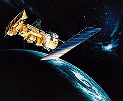
TIROS-8 was a spin-stabilized meteorological spacecraft designed to test experimental television techniques and infrared equipment. The satellite was in the form of an 18-sided right prism, 107 cm in diameter and 56 cm high. The top and sides of the spacecraft were covered with approximately 9000 1-by 2-cm silicon solar cells. It was equipped with 2 independent television camera subsystems for taking cloud cover pictures, plus an omnidirectional radiometer and a five-channel scanning radiometer for measuring radiation from the earth and its atmosphere. The satellite spin rate was maintained between 8 and 12 rpm by use of five diametrically opposed pairs of small, solid-fuel thrusters. Once operational, tiros was then called the National Oceanic and Atmospheric Administration or NOAA for short.

A magnetic attitude control device permitted the satellite spin axis to be oriented to within 1 to 2 deg of a predetermined attitude. The flight control system also optimized the performance of the solar cells and TV cameras and protected the five-channel infrared radiometer from prolonged exposure to direct sunlight.

TIROS-8 was the first satellite to be equipped with Automatic Picture Transmission (APT) capabilities. The APT experiment provided real-time earth-cloud pictures taken by the satellite to any properly equipped ground receiving station. In addition to an APT camera system, the satellite carried one wide-angle (104°) TV camera. Pictures taken by the TV camera were transmitted directly or were stored in a tape recorder on board for subsequent playback, depending on whether the spacecraft was within or beyond communication range of either of two ground receiving stations.

The spacecraft performed normally after launch. Over 50 ground stations participated in the APT experiment, which was terminated by the end of April 1964 due to degradation of the APT camera. The wide-angle TV camera transmitted useful data until February 12, 1966. The satellite was deactivated on July 1, 1967, after being left on for an additional time period for engineering purposes. [3]

See also

Related Research Articles

<span class="mw-page-title-main">TIROS-1</span>

TIROS-1 was the first full-scale weather satellite, the first of a series of Television Infrared Observation Satellites placed in low Earth orbit.

<span class="mw-page-title-main">Television Infrared Observation Satellite</span> Series of early American weather satellites

TIROS, or Television InfraRed Observation Satellite, is a series of early weather satellites launched by the United States, beginning with TIROS-1 in 1960. TIROS was the first satellite that was capable of remote sensing of the Earth, enabling scientists to view the Earth from a new perspective: space. The program, promoted by Harry Wexler, proved the usefulness of satellite weather observation, at a time when military reconnaissance satellites were secretly in development or use. TIROS demonstrated at that time that "the key to genius is often simplicity". TIROS is an acronym of "Television InfraRed Observation Satellite" and is also the plural of "tiro" which means "a young soldier, a beginner".

<span class="mw-page-title-main">NOAA-17</span>

NOAA-17, also known as NOAA-M before launch, was an operational, polar orbiting, weather satellite series operated by the National Environmental Satellite Service (NESS) of the National Oceanic and Atmospheric Administration (NOAA). NOAA-17 also continued the series of Advanced TIROS-N (ATN) spacecraft begun with the launch of NOAA-8 (NOAA-E) in 1983 but with additional new and improved instrumentation over the NOAA A-L series and a new launch vehicle.

<span class="mw-page-title-main">NOAA-18</span>

NOAA-18, also known as NOAA-N before launch, is an operational, polar orbiting, weather satellite series operated by the National Environmental Satellite Service (NESS) of the National Oceanic and Atmospheric Administration (NOAA). NOAA-18 also continued the series of Advanced TIROS-N (ATN) spacecraft begun with the launch of NOAA-8 (NOAA-E) in 1983 but with additional new and improved instrumentation over the NOAA A-M series and a new launch vehicle. NOAA-18 is in an afternoon equator-crossing orbit and replaced NOAA-17 as the prime afternoon spacecraft.

<span class="mw-page-title-main">TIROS-2</span>

TIROS 2 was a spin-stabilized meteorological satellite. It was the second in a series of Television Infrared Observation Satellites. It re-entered in May 2014.

<span class="mw-page-title-main">ESSA-1</span> Former American weather satellite

ESSA-1 was a spin-stabilized operational meteorological satellite. Its name was derived from that of its oversight agency, the Environmental Science Services Administration (ESSA).

<span class="mw-page-title-main">Kosmos 122</span>

Kosmos 122, launched on 25 June 1966, Meteor No.5L, and was one of eleven weather satellites put into orbit between 1964 and 1969.

<span class="mw-page-title-main">TIROS-3</span> Former American weather satellite

TIROS 3 was a spin-stabilized meteorological satellite. It was the third in a series of Television Infrared Observation Satellites.

<span class="mw-page-title-main">TIROS-4</span>

TIROS 4 was a spin-stabilized meteorological satellite. It was the fourth in a series of Television Infrared Observation Satellites.

<span class="mw-page-title-main">TIROS-5</span>

TIROS 5 was a spin-stabilized meteorological satellite. It was the fifth in a series of Television Infrared Observation Satellites.

<span class="mw-page-title-main">TIROS-6</span>

TIROS 6 was a spin-stabilized meteorological satellite. It was the sixth in a series of Television Infrared Observation Satellites.

<span class="mw-page-title-main">TIROS-7</span>

TIROS-7 was a spin-stabilized meteorological satellite. It was the seventh in a series of Television Infrared Observation Satellites.

<span class="mw-page-title-main">TIROS-9</span>

TIROS-9 was a spin-stabilized meteorological satellite. It was the ninth in a series of Television Infrared Observation Satellites.

<span class="mw-page-title-main">TIROS-10</span>

TIROS-10 was a spin-stabilized meteorological satellite. It was the tenth and last in a series of Television Infrared Observation Satellites.

<span class="mw-page-title-main">Nimbus 1</span>

Nimbus 1 was a meteorological satellite. It was the first in a series of the Nimbus program.

<span class="mw-page-title-main">Nimbus 2</span>

Nimbus 2 was a meteorological satellite. It was the second in a series of the Nimbus program.

<span class="mw-page-title-main">Nimbus 3</span>

Nimbus 3 was a meteorological satellite. It was the third in a series of the Nimbus program.

<span class="mw-page-title-main">Nimbus 4</span>

Nimbus 4 was a meteorological satellite. It was the fourth in a series of the Nimbus program.

<span class="mw-page-title-main">ITOS-B</span>

NOAA-1 was a weather satellite operated by the National Oceanic and Atmospheric Administration (NOAA). It was part of a series of satellites called ITOS, or improved TIROS. ITOS-B was released on October 21, 1971, from the Vandenberg Air Force Base, California, with a Delta rocket. It failed to achieve a successful Earth orbit. A malfunction in the second stage launch vehicle caused the spacecraft to reenter the Earth's atmosphere about 1 hour after lift-off.

NOAA-5, also known as ITOS-H was a weather satellite operated by the National Oceanic and Atmospheric Administration (NOAA). It was part of a series of satellites called ITOS, or improved TIROS, being the last of the series. NOAA-5 was launched on a Delta rocket on July 29, 1976.

References

  1. 1 2 3 4 5 6 7 8 "TIROS 8". National Space Science Data Center Master Catalog. NASA Goddard Space Flight Center. Retrieved June 4, 2018.
  2. McDowell, Jonathan. "Launch Log". Jonathan's Space Page. Retrieved June 4, 2018.
  3. "TIROS 8 (1963-054A)". NASA Goddard Space Flight Center. Retrieved June 4, 2018.PD-icon.svg This article incorporates text from this source, which is in the public domain .