Mission type | Weather |
---|---|
Operator | NOAA [1] |
COSPAR ID | 1971-091A |
Mission duration | Launch failure |
Spacecraft properties | |
Manufacturer | RCA Astro |
Launch mass | 687 kilograms (1,515 lb) |
Start of mission | |
Launch date | October 21, 1971, 00:00 UTC [2] |
Rocket | Delta N6 (572/D-86) |
Launch site | Vandenberg SLC-2E |
Orbital parameters | |
Reference system | Geocentric |
Regime | Sun-synchronous |
Epoch | Planned |
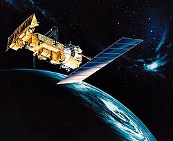
ITOS-B was a weather satellite operated by the National Oceanic and Atmospheric Administration (NOAA). It was part of a series of satellites called ITOS, or improved TIROS. [3]
ITOS-B was launched on October 21, 1971 from Vandenberg Air Force Base, California, on a Delta N6 (sn. 572/D-86) rocket. [4] It failed to achieve a successful Earth orbit. A malfunction in the second stage launch vehicle caused the spacecraft to reenter the Earth's atmosphere about 1 hour after lift-off.
ITOS-B was designed to provide improved operational infrared and visual observations of earth cloud cover for use in weather analysis and forecasting. Secondary objectives included obtaining both solar proton and global heat balance data on a daily basis. To accomplish these tasks, the Sun-synchronous spacecraft carried four cameras - 2 television cameras for automatic picture transmissions (APT) and two advanced vidicon camera system (AVCS) cameras. It also carried a low-resolution flat plate radiometer, a solar proton monitor, and two scanning radiometers that not only could measure emitted IR radiation but could also serve as a backup system for the APT and AVCS cameras.
The nearly cubical spacecraft measured 1 by 1 by 1.2 meters (3.3 ft × 3.3 ft × 3.9 ft). The TV cameras and infrared sensors were mounted on the satellite baseplate with their optical axes directed vertically earthward. The satellite was equipped with three curved solar panels that were folded during launch and were to be deployed after orbit was achieved. Each panel measured over 4.2 meters (14 ft) in length when unfolded and was covered with 3420 solar cells, each 2 centimeters (0.79 in) by 2 centimeters (0.79 in). A dynamics and attitude control system was designed to maintain desired spacecraft orientation through gyroscopic principles incorporated into the satellite design. Earth orientation was to be maintained by taking advantage of the precession induced from a momentum flywheel so that the satellite body precession rate of one revolution per orbit would provide the desired 'Earth looking' attitude. Minor adjustments in attitude and orientation could be made by means of magnetic coils and by varying the speed of the momentum flywheel. [1]
Television InfraRed Observation Satellite (TIROS) is a series of early weather satellites launched by the United States, beginning with TIROS-1 in 1960. TIROS was the first satellite that was capable of remote sensing of the Earth, enabling scientists to view the Earth from a new perspective: space. The program, promoted by Harry Wexler, proved the usefulness of satellite weather observation, at a time when military reconnaissance satellites were secretly in development or use. TIROS demonstrated at that time that "the key to genius is often simplicity". TIROS is an acronym of "Television InfraRed Observation Satellite" and is also the plural of "tiro" which means "a young soldier, a beginner".
NOAA-17, also known as NOAA-M before launch, was an operational, polar orbiting, weather satellite series operated by the National Environmental Satellite Service (NESS) of the National Oceanic and Atmospheric Administration (NOAA). NOAA-17 also continued the series of Advanced TIROS-N (ATN) spacecraft begun with the launch of NOAA-8 (NOAA-E) in 1983 but with additional new and improved instrumentation over the NOAA A-L series and a new launch vehicle.
NOAA-16, also known as NOAA-L before launch, was an operational, polar orbiting, weather satellite series operated by the National Environmental Satellite Service (NESS) of the National Oceanic and Atmospheric Administration (NOAA). NOAA-16 continued the series of Advanced TIROS-N (ATN) spacecraft that began with the launch of NOAA-8 (NOAA-E) in 1983; but it had additional new and improved instrumentation over the NOAA A-K series and a new launch vehicle. It was launched on 21 September 2000 and, following an unknown anomaly, it was decommissioned on 9 June 2014. In November 2015 it broke up in orbit, creating more than 200 pieces of debris.
NOAA-18, also known as NOAA-N before launch, is an operational, polar orbiting, weather satellite series operated by the National Environmental Satellite Service (NESS) of the National Oceanic and Atmospheric Administration (NOAA). NOAA-18 also continued the series of Advanced TIROS-N (ATN) spacecraft begun with the launch of NOAA-8 (NOAA-E) in 1983 but with additional new and improved instrumentation over the NOAA A-M series and a new launch vehicle. NOAA-18 is in an afternoon equator-crossing orbit and replaced NOAA-17 as the prime afternoon spacecraft.
NOAA-15, also known as NOAA-K before launch, is an operational, polar-orbiting of the NASA-provided Television Infrared Observation Satellite (TIROS) series of weather forecasting satellite operated by National Oceanic and Atmospheric Administration (NOAA). NOAA-15 was the latest in the Advanced TIROS-N (ATN) series. It provided support to environmental monitoring by complementing the NOAA/NESS Geostationary Operational Environmental Satellite program (GOES).
NOAA-13, also known as NOAA-I before launch, was an American weather satellite operated by the National Oceanic and Atmospheric Administration (NOAA). NOAA-I continued the operational, polar orbiting, meteorological satellite series operated by the National Environmental Satellite System (NESS) of the National Oceanic and Atmospheric Administration (NOAA). NOAA-I continued the series (fifth) of Advanced TIROS-N (ATN) spacecraft begun with the launch of NOAA-8 (NOAA-E) in 1983. NOAA-I was in an afternoon equator-crossing orbit and was intended to replace the NOAA-11 (NOAA-H) as the prime afternoon (14:00) spacecraft.
NOAA-7, known as NOAA-C before launch, was an American operational weather satellite for use in the National Operational Environmental Satellite System (NOESS) and for the support of the Global Atmospheric Research Program (GARP) during 1978-1984. The satellite design provided an economical and stable Sun-synchronous platform for advanced operational instruments to measure the atmosphere of Earth, its surface and cloud cover, and the near-space environment. An earlier launch, NOAA-B, was scheduled to become NOAA-7, however NOAA-B failed to reach its required orbit.
NOAA-6, known as NOAA-A before launch, was an American operational weather satellite for use in the National Operational Environmental Satellite System (NOESS) and for the support of the Global Atmospheric Research Program (GARP) during 1978–1984. The satellite design provided an economical and stable Sun-synchronous platform for advanced operational instruments to measure the atmosphere of Earth, its surface and cloud cover, and the near-space environment.
NOAA B was an American operational weather satellite for use in the National Operational Environmental Satellite System (NOESS) and for the support of the Global Atmospheric Research Program (GARP) during 1978-1984. The satellite design provided an economical and stable Sun-synchronous platform for advanced operational instruments to measure the atmosphere of Earth, its surface and cloud cover, and the near-space environment.
TIROS-3 was a spin-stabilized meteorological satellite. It was the third in a series of Television Infrared Observation Satellites.
TIROS-8 was a spin-stabilized meteorological satellite. It was the eighth in a series of Television Infrared Observation Satellites.
NOAA-1, also known as ITOS-A was a weather satellite operated by the National Oceanic and Atmospheric Administration (NOAA). It was part of a series of satellites called ITOS, or improved TIROS.
NOAA-2, also known as ITOS-D was a weather satellite operated by the National Oceanic and Atmospheric Administration (NOAA). It was part of a series of satellites called ITOS, or improved TIROS. NOAA-2 was launched on a Delta rocket on October 15, 1972. The launch carried one other satellite: AMSAT-OSCAR 6.
NOAA-5, also known as ITOS-H was a weather satellite operated by the National Oceanic and Atmospheric Administration (NOAA). It was part of a series of satellites called ITOS, or improved TIROS, being the last of the series. NOAA-5 was launched on a Delta rocket on July 29, 1976.
NOAA-8, known as NOAA-E before launch, was an American weather satellite operated by the National Oceanic and Atmospheric Administration (NOAA) for use in the National Environmental Satellite Data and Information Service (NESDIS). It was first of the Advanced TIROS-N series of satellites. The satellite design provided an economical and stable Sun-synchronous platform for advanced operational instruments to measure the atmosphere of Earth, its surface and cloud cover, and the near-space environment.
NOAA-9, known as NOAA-F before launch, was an American weather satellite operated by the National Oceanic and Atmospheric Administration (NOAA) for use in the National Environmental Satellite Data and Information Service (NESDIS). It was the second of the Advanced TIROS-N series of satellites. The satellite design provided an economical and stable Sun-synchronous platform for advanced operational instruments to measure the atmosphere of Earth, its surface and cloud cover, and the near-space environment.
NOAA-10, known as NOAA-G before launch, was an American weather satellite operated by the National Oceanic and Atmospheric Administration (NOAA) for use in the National Environmental Satellite Data and Information Service (NESDIS). It was the third of the Advanced TIROS-N series of satellites. The satellite design provided an economical and stable Sun-synchronous platform for advanced operational instruments to measure the atmosphere of Earth, its surface and cloud cover, and the near-space environment.
NOAA-11, known as NOAA-H before launch, was an American weather satellite operated by the National Oceanic and Atmospheric Administration (NOAA) for use in the National Operational Environmental Satellite System (NOESS) and for support of the Global Atmospheric Research Program (GARP) during 1978–1984. It was the fourth of the Advanced TIROS-N series of satellites. The satellite design provided an economical and stable Sun-synchronous platform for advanced operational instruments to measure the atmosphere of Earth, its surface and cloud cover, and the near-space environment.
NOAA-12, also known as NOAA-D before launch, was an American weather satellite operated by National Oceanic and Atmospheric Administration (NOAA), an operational meteorological satellite for use in the National Environmental Satellite, Data, and Information Service (NESDIS). The satellite design provided an economical and stable Sun-synchronous platform for advanced operational instruments to measure the atmosphere of Earth, its surface and cloud cover, and the near-space environment.
NOAA-14, also known as NOAA-J before launch, was an American weather satellite operated by the National Oceanic and Atmospheric Administration (NOAA). NOAA-14 continued the third-generation operational, Polar Orbiting Environmental Satellite (POES) series operated by the National Environmental Satellite Service (NESS) of the National Oceanic and Atmospheric Administration (NOAA). NOAA-14 continued the series of Advanced TIROS-N (ATN) spacecraft begun with the launch of NOAA-8 (NOAA-E) in 1983.