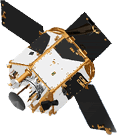
RazakSAT

Last updated
RazakSAT
RazakSat.gif
RazakSAT
Operator Astronautic Technology Sdn Bhd (ATSB)
COSPAR ID 2009-037A OOjs UI icon edit-ltr-progressive.svg
SATCAT no. 35578
Spacecraft properties
Launch massInstruments: 50 kilograms (110 lb)
Total: 180 kilograms (400 lb)
Power300 watts
Start of mission
Launch date14 July 2009, 03:35 (2009-07-14UTC03:35Z) UTC
Rocket Falcon 1
Launch site Omelek
Contractor SpaceX
End of mission
Last contactDecember 2010
Orbital parameters
Reference system Geocentric
Regime Low Earth
Perigee altitude 667 kilometers (414 mi) [1]
Apogee altitude 691 kilometers (429 mi) [1]
Inclination 8.910 degrees [1]
Period 98.20 minutes [1]
Epoch 25 January 2015, 03:33:28 UTC [1]
Main camera
NameMedium-sized Aperture Camera (MAC)
 

RazakSAT is a Malaysian Earth observation satellite carrying a high-resolution camera. It was launched into low Earth orbit on 14 July 2009. It was placed in a near-equatorial orbit that presents many imaging opportunities for the equatorial region. It weighs over three times as much as TiungSAT-1 and carries a high-resolution Earth observation camera. Developed in conjunction with the Satrec Initiative, the satellite's low inclination (9 degrees) brought it over Malaysia a dozen or more times per day. This was intended to provide greatly increased coverage of Malaysia compared to most other Earth observation satellites. [2] An audit report released in October 2011 revealed that the satellite had failed after one year of operation. [3]

Contents

RazakSAT was the only operational satellite to be put into orbit by SpaceX's Falcon 1.

Background

This satellite is Malaysia's second remote sensing satellite after TiungSAT-1.

Originally called MACSAT, RazakSAT's payload is mainly electro-optical, carrying a Medium-sized Aperture Camera (MAC) which is a pushbroom camera with five linear detectors (one panchromatic, four multi-spectral) weighing approximately 50 kg. The entire satellite weighs at about 180 kg. [4]

Launch

SpaceX launched RazakSAT at 03:35 UTC on 14 July 2009 using a Falcon 1 rocket. This was the fifth flight of a Falcon 1, and like the previous flights lift-off was from Omelek Island in the Kwajalein Atoll. At 05:25 UTC Elon Musk, founder and CEO of SpaceX, told a reporter the launch had been a success. "We nailed the orbit to well within target parameters...pretty much a bullseye." Musk said. [5]

Operations

RazakSAT's mission plan was carried out by engineers from Astronautic Technology Sdn Bhd (ATSB). This was especially important because Malaysia is usually covered by the equatorial cloud bands. Normal Sun-synchronous optical satellites, which may re-visit an area only once every 7 days, will almost never be able to see the ground during their pass. As a result, much optical satellite imagery of Malaysia have more than 50% cloud cover within the image's footprint.

Razaksat, on the other hand, revisited some parts of Malaysian territory every 90 minutes, potentially maximising its ability to exploit gaps in the clouds.[ citation needed ]

RazakSAT, equipped with a high resolution Medium-Sized Aperture Camera (MAC), achieved the intended Near-Equatorial Low Earth Orbit (NEqO) at 685 km altitude and a 9 degree inclination. It was expected to provide high resolution images of Malaysia that can be applied to land management, resource development and forestry. [2]

The NEqO orbit has three distinct disadvantages. Analysis through the commercially available Satellite Tool Kit (STK) software had shown that the orbit revisit over Malaysia was found to have a maximum peak of 2-4 overpasses per day during daylight hours (from 8 am to 6:30 pm) to a period of 6 consecutive days without any usable daylight overpasses. The second disadvantage is that most imagery acquired through the NEqO orbit are not usable through a remote sensing perspective as the NEqO orbit is not a Sun-synchronous orbit, a vital criterion for monitoring and analysis work. Thirdly, it was found that the NEqO orbit exposes the satellite to the South Atlantic Anomaly (SAA) phenomenon on every orbit it takes around the Earth unlike the polar orbit, near-polar or Sun-synchronous orbits, thereby further increasing the risk of radiation damage to the satellite.[ citation needed ]

Although it was originally intended as a Research & Development (R&D) project but it was later announced for commercial purposes in 2009, [6] the aim of the RazakSAT project was asserted as a Research & Development (R&D) Project in 2010. [3]

During its operations after its launch in 2009, it was discovered that the RazakSAT satellite could not achieve its targeted pointing accuracy of within 1 km of its intended target. The Malaysian English newspaper The Star, quoting from the Malaysian Government Auditor-General's Report 2010, reported that the images that were acquired by the RazakSAT satellite was found to be 37 km off their intended target. [7]

As a result of the pointing error, all of the over 1,328 images acquired by the satellite were rendered unusable. Despite a promise of delivering MAC images by 2010, as of the end of 2011, the operators have not released any images. Efforts to fix the problems with the satellite were terminated in December 2010. [8]

Specifications

The major specification of RazakSAT, as provided by the satellites' builder and operator (ATSB) in February 2010, are: [9]

SubsystemsSpecifications
Altitude685 km
Inclination
Payload (MAC)GSD : 2.5 m (PAN), 5 m (MS)
Swathwidth : 20 km @ 685 km
Attitude Determination & Control Subsystem (ADCS)Three-axis stabilization based on four reaction wheels
Pointing Accuracy : < 0.2° (2 s)
Pointing Knowledge : 1 arcmin (2 s)
Electrical Power Subsystem (EPS)GaAs/Ge solar cells on honeycomb substrate
NiCd batteries (18 Ahr)
Peak Power Tracking (PPT) & constant current control
Solar Power : >300 W @ EOL
Command & Data Handling Subsystem (C&DH)Two on-board computers
Telemetry and command interface modules
Analog Telemetry channels : up to 90
Digital Telemetry channels : up to 120
Telecommunication Subsystem (TS)9,600 bit/s / 1,200 bit/s S-band TT&C uplink
38.4 kbs / 9,600 bit/s / 1,200 bit/s S-band TT&C downlink
Payload Data Management32 Gbit On-board solid-state memory
30 Mbit/s X band payload data downlink
Structure & ThermalØ1,200 × 1,200 mm Hexagonal shape
Mass : 180 kg
Modular structure
Passive & Active thermal control
Mission Lifetime3 Years

Satellite bus

The satellite bus used for RazakSAT was jointly developed by ATSB and Satrec Initiative, a commercial satellite manufacturer in Korea. Satrec Initiative markets the bus system as the "SI-200". [10]

See also

Related Research Articles

<span class="mw-page-title-main">Envisat</span> ESA Earth observation satellite (2002–2012)

Envisat is a large Earth-observing satellite which has been inactive since 2012. It is still in orbit and considered space debris. Operated by the European Space Agency (ESA), it was the world's largest civilian Earth observation satellite.

<span class="mw-page-title-main">EROS (satellite)</span> Israeli commercial Earth observation satellite series

Earth Resources Observation Satellite (EROS) is a series of Israeli commercial Earth observation satellites, designed and manufactured by Israel Aircraft Industries (IAI), with optical payload supplied by El-Op. The satellites are owned and operated by ImageSat International N.V. (ISI), a company founded in 1997, as a Joint venture between IAI, El-Op and Core Software Technology (CST). EROS A was launched on December 5, 2000 and EROS B on April 25, 2006.

<span class="mw-page-title-main">National Space Agency (Malaysia)</span> Malaysian National Space Agency

The National Space Agency, abbreviated ANGKASA, was the national space agency of Malaysia. It was established in 2002 and its charter aims to upgrade, stimulate and foster the country's space programme through integrated and coordinated efforts by developing and applying space technologies.

TiungSAT-1 is the first Malaysian microsatellite. The satellite is developed through the technology transfer and training programme between Astronautic Technology Sdn Bhd (ATSB) Malaysia and Surrey Satellite Technology Ltd., United Kingdom. TiungSAT-1 was launched aboard Dnepr rocket from Baikonur Cosmodrome, Kazakhstan on 26 September 2000.

KOMPSAT-2, also known as Arirang-2, is a South Korean multipurpose Earth observation satellite. It was launched from Plesetsk Cosmodrome, Russia at 07:45:43 UTC on 28 July 2006. It began to transmit signals at 14:00 UTC the same day. Like the earlier KOMPSAT-1 satellite, it takes its name from the popular Korean folk song Arirang. Its launch was the culmination of a project begun in 1995.

Astronautic Technology Sdn Bhd or better known as ATSB was established on 1 May 1995 and is wholly owned by the Minister of Finance Inc under the supervision of the Malaysian Ministry of Energy, Science, Technology, Environment and Climate Change (MESTECC).

<span class="mw-page-title-main">DubaiSat-1</span>

DubaiSat-1 is a remote sensing Earth observation satellite built by the Emirates Institution for Advanced Science and Technology (EIAST) under an agreement with Satrec Initiative, a satellite manufacturing company in South Korea.

<span class="mw-page-title-main">Science and technology in Malaysia</span>

Science policy in Malaysia is regulated by the Ministry of Science, Technology, and Innovation. The ministry focuses on five areas: biotechnology, ICT policy, industry, sea to space and core science and technology. Other ministries, such as the Ministry of Agriculture and the Ministry of Health also have science departments. Training in scientific areas was promoted during the 1970s and 1980s. From 1987 to 1997 research and development used 0.24% of GNP, and in 1998 high-tech exports made up 54% of Malaysia's manufactured exports.

<span class="mw-page-title-main">SI-200</span>

The SI-200 satellite bus was a model of satellite, based on the Malaysian RazakSAT, produced by the South Korean Satrec Initiative. The bus was suitable for small satellites where the accommodation of Earth observation or other scientific payloads is required, and was used on the Emirati remote sensing satellite DubaiSat-1 launched in 2009.

IRS-1D is the seventh satellite in Indian Remote Sensing satellite series of Earth Observation satellites, built, launched and maintained by Indian Space Research Organisation (ISRO). The satellite has similar capabilities as that of ISRO's IRS-1C satellite with some improvements added for better imagery particularly in thematic mapping.

<span class="mw-page-title-main">DubaiSat-2</span>

DubaiSat-2 is an electro-optical Earth observation satellite built by the Emirates Institution for Advanced Science and Technology under an agreement with Satrec Initiative, a satellite manufacturing company in South Korea. EIAST's objective with DubaiSat-2 is to provide electro-optical images, that can be commercialized, for users within the United Arab Emirates and beyond and to develop and implement new technologies not used in DubaiSat-1. EIAST also intends to continue manpower training for the UAE's space program. 16 UAE engineers have been working on the design, development, testing and manufacturing of the satellite. The participation of the UAE engineers, who are currently working in South Korea, has increased by 100 percent from the DubaiSat-1 project.

RASAT was an Earth observation satellite designed and developed by TÜBİTAK Space Technologies Research Institute and produced in Turkey to provide high resolution imagery. It was the first remote sensing satellite fully realized in Turkey, and the second indigenously developed remote sensing satellite after BILSAT-1.

<span class="mw-page-title-main">Planet Labs</span> American company specializing in satellite imaging of Earth

Planet Labs PBC is an American public Earth imaging company based in San Francisco, California. Their goal is to image the entirety of the Earth daily to monitor changes and pinpoint trends.

<span class="mw-page-title-main">KhalifaSat</span>

KhalifaSat, also known as DubaiSat-3, is a remote sensing Earth observation satellite that was designed and built at the Space Technology Laboratories of the Mohammed bin Rashid Space Centre in Dubai. It is considered the first entirely Emirati-made satellite. It launched into orbit on 30 October 2018 from Japan's Tanegashima Space Center using the Korean Satrec SI-300 bus.

Cartosat-2C is an Earth observation satellite in a Sun-synchronous orbit (SSO) and is a fifth flight unit of Cartosat series of satellites. It is a geostationary satellite and appears stationary over a place on the earth. The satellite is built at space application centre Ahmedabad, launched and maintained by the Indian Space Research Organisation (ISRO). It was launched on 22 June 2016.

<span class="mw-page-title-main">Cartosat-2D</span> Indian Earth observation satellite

Cartosat-2D is an Earth observation satellite in a Sun-synchronous orbit (SSO) and the fifth of the Cartosat series of satellites. The satellite is built, launched and maintained by the Indian Space Research Organisation (ISRO). Cartosat-2D has a mass of 714 kg.

<span class="mw-page-title-main">Paz (satellite)</span> Spanish military Earth observation satellite

Paz is a Spanish Earth observation and reconnaissance satellite launched on 22 February 2018. It is Spain's first spy satellite. The satellite is operated by Hisdesat. Paz was previously referred to as SEOSAR.

Satrec Initiative Co., Ltd. or Satrec i or SI is a South Korean satellite manufacturing company headquartered in Daejeon, South Korea The company was founded in 1999 by the engineers who developed the first Korean satellite (KITSAT-1) at KAIST Satellite Technology Research Center (SaTRec). The company designs and builds Earth observation satellites called SpaceEye-series, and it provides various space components, including high resolution electro-optical payloads and star-trackers. SI's first satellite was a Malaysian Earth observation satellite, RazakSAT launched in 2009. SI has two subsidiaries: SI Imaging Services (SIIS) is the exclusive image data provider of KOMPSAT-series, and SI Analytics (SIA) provides AI-native GEOINT solutions for satellite imagery. SI also spun-off SI Detection (SID), which provides radiation monitoring solutions.

<span class="mw-page-title-main">UiTMSAT-1</span> First nanosatellite Malaysian spacecraft

UiTMSAT-1 was a Malaysian nanosatellite, built primarily by Universiti Teknologi MARA (UiTM) as part of the multi-nation Birds-2 project. The 1U CubeSat was launched into space on 29 June 2018 and deployed from the International Space Station (ISS) on 10 August 2018.

<span class="mw-page-title-main">EOS SAT-1</span> Privately owned satellite

EOS SAT-1 is an optical Earth observation satellite for agricultural land monitoring by EOS Data Analytics, Inc., a global AI-powered satellite imagery analytics provider. The space optics instrument and satellite manufacturer Dragonfly Aerospace built the satellite and equipped it with two high-resolution DragonEye cameras.

References

  1. 1 2 3 4 5 "RAZAKSAT Satellite details 2009-037A NORAD 35578". N2YO. 25 January 2015. Retrieved 25 January 2015.
  2. 1 2 "Falcon 1 Flight 5". SpaceX. Archived from the original on 2011-01-04.
  3. 1 2 "RM142m RazakSAT faulty after just one year, says federal auditor - The Malaysian Insider". themalaysianinsider.com. Archived from the original on 2014-10-14. Retrieved 2014-09-13.
  4. "Inside Razaksat". Magazine article. Asian Surveying and Mapping. 2008-04-07. Archived from the original on 2009-03-28. Retrieved 2009-07-28.
  5. "Falcon Launch Report". Spaceflight Now.
  6. "Archives | The Star Online". thestar.com.my. Archived from the original on 2009-03-25. Retrieved 2014-09-13.
  7. "RM142mil satellite is 37km off target" Archived 2011-10-27 at the Wayback Machine (The Star, Nation, page 4, 25 October 2011)
  8. "RM142m RazakSAT faulty after just one year, says federal auditor" Archived 2014-10-14 at the Wayback Machine dated 25 October 2011 (Shannon Teoh, Malaysian Insider, 25 October 2011).
  9. RazakSAT - The High Resolution Earth Observation Satellite - Specification, ATSB website, web page date uncertain, retrieved 2010-02-11.
  10. "SI-200". Satrec Initiative. Archived from the original on 2009-01-05.