Jason-3

Last updated

Jason-3
Jason-3 2015 illustration (crop).jpg
Artist's impression of the Jason-3 satellite
Mission type Oceanography mission
Operator NASA, NOAA, CNES, EUMETSAT
COSPAR ID 2016-002A OOjs UI icon edit-ltr-progressive.svg
SATCAT no. 41240
Website https://www.nesdis.noaa.gov/jason-3
Mission duration5 years (planned)
7 years, 11 months and 5 days (elapsed)
Spacecraft properties
Bus Proteus
Manufacturer Thales Alenia Space
Launch mass553 kg (1,219 lb) [1]
Dry mass525 kg (1,157 lb) [1]
Power550 watts
Start of mission
Launch date17 January 2016, 18:42:18 UTC [2]
Rocket Falcon 9 v1.1
Launch site Vandenberg, SLC-4E
Contractor SpaceX
Orbital parameters
Reference system Geocentric orbit [3]
Regime Low Earth orbit
Perigee altitude 1,331.7 km (827.5 mi)
Apogee altitude 1,343.7 km (834.9 mi)
Inclination 66.04°
Period 112.42 minutes
Repeat interval9.92 days
 

Jason-3 is a satellite altimeter created by a partnership of the European Organisation for the Exploitation of Meteorological Satellites (EUMETSAT) and National Aeronautic and Space Administration (NASA), and is an international cooperative mission in which National Oceanic and Atmospheric Administration (NOAA) is partnering with the Centre National d'Études Spatiales (CNES, French space agency). The satellite's mission is to supply data for scientific, commercial, and practical applications to sea level rise, sea surface temperature, ocean temperature circulation, and climate change. [4]

Contents

Mission objectives

Jason-3 makes precise measurements related to global sea-surface height. Because sea surface height is measured via altimetry, mesoscale ocean features are better simulated since the Jason-3 radar altimeter can measure global sea-level variations with very high accuracy. [5] [6] The scientific goal is to produce global sea-surface height measurements every 10 days to an accuracy of less than 4 cm. [7] In order to calibrate the radar altimeter, a microwave radiometer measures signal delay caused by atmospheric vapors, ultimately correcting the altimeter's accuracy to 3.3 cm. [5] [8] This data is important to collect and analyze because it is a critical factor in understanding the changes in Earth's climate brought on by global warming as well as ocean circulation. [6] NOAA's National Weather Service uses Jason-3's data to more accurately forecast tropical cyclones. [9]

Scientific applications

The primary users of Jason-3 data are people who are dependent on marine and weather forecasts for public safety, commerce and environmental purposes. Other users include scientists and people who are concerned with global warming and its relation to the ocean. National Oceanic and Atmospheric Administration (NOAA) and European Organisation for the Exploitation of Meteorological Satellites (EUMETSAT) are using the data primarily for monitoring wind and waves on the high seas, hurricane intensity, ocean surface currents, El Niño and La Niña forecasts, water levels of lakes and rivers. Jason-3 also reports on environmental issues such as algae blooms and oil spills. [10] NASA and CNES are more interested in the research aspect, in terms of understanding and planning for climate change. Jason-3 can measure climate change via sea surface height because sea surface rise, averaged over annual time scales, is accelerated by warming global temperatures. [5] Ultimately, the benefits of Jason-3 data will transfer to people and to the economy.

Orbit

Animation of Jason-3's orbit from 20 May 2018 to 14 November 2018. Earth is not shown. Animation of Jason-3 trajectory.gif
Animation of Jason-3's orbit from 20 May 2018 to 14 November 2018. Earth is not shown.

Jason-3 flies at the same 9.9-day repeat track orbit and this means the satellite will make observations over the same ocean point every 9.9 days. The orbital parameters are: 66.05º inclination, 1,380 km apogee, 1,328 km perigee, 112 minutes per revolution around Earth. It was set to fly 1 minute behind the now decommissioned Jason-2. The 1-minute time delay was applied in order to not miss any data collection between missions.

Orbit determination instruments

In order to detect sea level change, we need to know the orbit height of the satellites as they revolve around Earth, to within 1 cm (0.4 inches). Combining instruments from three different techniques—GPS, DORIS, LRA. The GPS receiver on Jason-3 uses data from the constellation of GPS satellites in orbit to constantly determine its position in orbit. [4] Similarly, DORIS is another system to help determine orbit positioning. Designed by CNES in France, DORIS uses the Doppler effect to found its system, which describes the differences in frequencies of waves between source and object. [11] [12] Thirdly, LRA (Laser Retroreflector Array), which is an instance of satellite laser ranging (SLR), uses corner reflectors on board the satellite to track the time it takes for lasers shot from Earth to reach the satellite and be reflected back, which can then be analyzed to understand the orbital positioning of Jason-3 from ground tracking stations. These three techniques (GPS, DORIS, LRA) all aid in determining orbit height and positioning. [13]

Launch

Falcon 9 rolling out on 15 January 2015 Jason-3 Rollout (24038722499) (2).jpg
Falcon 9 rolling out on 15 January 2015

Appearing on the SpaceX manifest as early as July 2013, [14] Jason-3 was originally scheduled for launch on 22 July 2015. However, this date was pushed back to 19 August 2015 following the discovery of contamination in one of the satellite's thrusters, requiring the thruster to be replaced and further inspected. [15] [16] The launch was further delayed by several months due to the loss of a Falcon 9 rocket with the CRS-7 mission on 28 June 2015. [17]

After SpaceX conducted their return-to-flight mission in December 2015 with the upgraded Falcon 9 Full Thrust, Jason-3 was assigned to the final previous-generation Falcon 9 v1.1 rocket, although some parts of the rocket body had been reworked following the findings of the failure investigation. [18] [19]

A 7-second static fire test of the rocket was completed on 11 January 2016. [20] The Launch Readiness Review was signed off by all parties on 15 January 2016, and the launch proceeded successfully on 17 January 2016, at 18:42 UTC. The Jason-3 payload was deployed into its target orbit at 830 mi (1,340 km) altitude after an orbital insertion burn about 56 minutes into the flight. [21] It was the 21st Falcon 9 flight overall [18] and the second into a high-inclination orbit from Vandenberg Air Force Base Space Launch Complex 4E in California. [15]

Post-mission landing test

First stage of Falcon 9 Flight 21 descending over the floating landing platform, 17 January 2016 First stage of Jason-3 rocket (24423604506).jpg
First stage of Falcon 9 Flight 21 descending over the floating landing platform, 17 January 2016

Following paperwork filed with US regulatory authorities in 2015, [22] SpaceX confirmed in January 2016 that they would attempt a controlled-descent flight test and vertical landing of the rocket's first stage on their west-coast floating platform Just Read the Instructions, [23] located about 200 mi (320 km) out in the Pacific Ocean.

This attempt followed the first successful landing and booster recovery on the previous launch in December 2015. [24] [25] The controlled descent through the atmosphere and landing attempt for each booster is an arrangement that is not used on other orbital launch vehicles. [26]

Approximately nine minutes into the flight, the live video feed from the drone ship went down due to the losing its lock on the uplink satellite. Elon Musk later reported that the first stage did touch down smoothly on the ship, but a lockout on one of the four landing legs failed to latch, so that the booster fell over and was destroyed. [27] [28] [29]

Debris from the fire, including several rocket engines attached to the octaweb assembly, arrived back to shore on board the floating landing platform on 18 January 2016. [30]

See also

Related Research Articles

<span class="mw-page-title-main">Weather satellite</span> Type of satellite designed to record the state of the Earths atmosphere

A weather satellite or meteorological satellite is a type of Earth observation satellite that is primarily used to monitor the weather and climate of the Earth. Satellites can be polar orbiting, or geostationary.

<span class="mw-page-title-main">EUMETSAT</span> European intergovernmental organisation

The European Organisation for the Exploitation of Meteorological Satellites (EUMETSAT) is an intergovernmental organisation created through an international convention agreed by a current total of 30 European Member States.

<span class="mw-page-title-main">TOPEX/Poseidon</span> Satellite mission to map ocean surface topography

TOPEX/Poseidon was a joint satellite altimeter mission between NASA, the U.S. space agency; and CNES, the French space agency, to map ocean surface topography. Launched on August 10, 1992, it was the first major oceanographic research satellite. TOPEX/Poseidon helped revolutionize oceanography by providing data previously impossible to obtain. Oceanographer Walter Munk described TOPEX/Poseidon as "the most successful ocean experiment of all time." A malfunction ended normal satellite operations in January 2006.

<span class="mw-page-title-main">Falcon 9</span> Orbital launch vehicle by SpaceX

Falcon 9 is a partially reusable medium-lift launch vehicle that can carry cargo and crew into Earth orbit, designed, manufactured and launched by American aerospace company SpaceX.
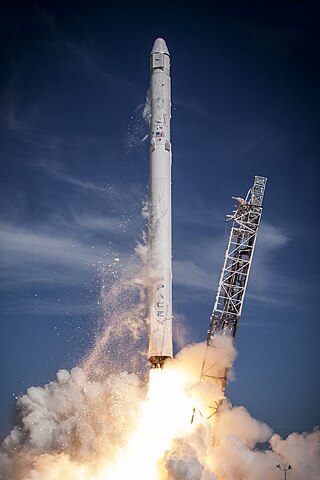
 It can also be used as an expendable heavy-lift launch vehicle. The first Falcon 9 launch was on 4 June 2010. The first Falcon 9 commercial resupply mission to the International Space Station (ISS) launched on 8 October 2012. In 2020 it became the first commercial rocket to ever launch humans to orbit and is currently the only such vehicle capable of doing so. It is the only U.S. rocket currently certified for transporting humans to the ISS. In 2022, it became the U.S. rocket with the most launches in history and with the best safety record, having suffered just one flight failure.

<span class="mw-page-title-main">OSTM/Jason-2</span> International Earth observation satellite mission

OSTM/Jason-2, or Ocean Surface Topography Mission/Jason-2 satellite, was an international Earth observation satellite altimeter joint mission for sea surface height measurements between NASA and CNES. It was the third satellite in a series started in 1992 by the NASA/CNES TOPEX/Poseidon mission and continued by the NASA/CNES Jason-1 mission launched in 2001.

Orbcomm is a family of low Earth orbit communications satellites, operated by the United States satellite communications company Orbcomm. As of July 2014, 51 such satellites have orbited Earth, with 50 still continuing to do so.

<span class="mw-page-title-main">SARAL</span> Indian Earth observation satellite

SARAL is a cooperative altimetry technology mission of Indian Space Research Organisation (ISRO) and Centre National d'Études Spatiales (CNES). SARAL performs altimetric measurements designed to study ocean circulation and sea surface elevation.

<span class="mw-page-title-main">2015 in spaceflight</span> Spaceflight-related events during the year 2015

In 2015, the maiden spaceflights of the Chinese Long March 6 and Long March 11 launch vehicles took place.

<span class="mw-page-title-main">Falcon 9 v1.1</span> Second version of SpaceXs Falcon 9 orbital launch vehicle

Falcon 9 v1.1 was the second version of SpaceX's Falcon 9 orbital launch vehicle. The rocket was developed in 2011–2013, made its maiden launch in September 2013, and its final flight in January 2016. The Falcon 9 rocket was fully designed, manufactured, and operated by SpaceX. Following the second Commercial Resupply Services (CRS) launch, the initial version Falcon 9 v1.0 was retired from use and replaced by the v1.1 version.

<span class="mw-page-title-main">Falcon 9 first-stage landing tests</span> Proofs of the SpaceX boosters reusability

The Falcon 9 first-stage landing tests were a series of controlled-descent flight tests conducted by SpaceX between 2013 and 2016. Since 2017, the first stage of Falcon 9 missions has been routinely landed if the rocket performance allowed it, and if SpaceX chose to recover the stage.

Autonomous spaceport drone ship Floating landing platform operated by SpaceX

An autonomous spaceport drone ship (ASDS) is an ocean-going vessel derived from a deck barge, outfitted with station-keeping engines and a large landing platform, and is autonomously positioned when on station for a landing. Construction of the drone ships was commissioned by aerospace company SpaceX to allow recovery of launch vehicle boosters at sea for missions that do not carry sufficient fuel to return to the launch site after boosting spacecraft onto an orbital or interplanetary trajectory.

<span class="mw-page-title-main">Falcon 9 Full Thrust</span> Third major version of the SpaceX Falcon 9 orbital launch vehicle

Falcon 9 Full Thrust is a partially reusable medium-lift launch vehicle, designed and manufactured by SpaceX. It was first designed in 2014–2015, with its first launch operations in December 2015. As of 19 December 2023, Falcon 9 Full Thrust had performed 262 launches without any failures. Based on the Lewis point estimate of reliability, this rocket is the most reliable orbital launch vehicle currently in operation.

<span class="mw-page-title-main">Timeline of private spaceflight</span>

The following is a timeline of important events in the history of private spaceflight, including important technical as well as legislative and political advances. Though the industry has its origins in the early 1960s, soon after the beginning of the Space Age, private companies did not begin conducting launches into space until the 1980s, and it was not until the 21st century that multiple companies began privately developing and operating launch vehicles and spacecraft in earnest.

GOES-U is a planned weather satellite, the fourth and last of the GOES-R series of satellites operated by the National Oceanic and Atmospheric Administration (NOAA). The GOES-R series will extend the availability of the Geostationary Operational Environmental Satellite (GOES) system until 2036. The satellite will be built by Lockheed Martin, based on the A2100 platform.

<span class="mw-page-title-main">Falcon 9 Block 5</span> Version of the Falcon 9 launch vehicle

Falcon 9 Block 5 is a partially reusable two-stage-to-orbit medium-lift launch vehicle designed and manufactured in the United States by SpaceX. It is the fifth version of Falcon 9 Full Thrust, powered by SpaceX Merlin engines burning rocket-grade kerosene (RP-1) and liquid oxygen (LOX).

<span class="mw-page-title-main">Sentinel-6 Michael Freilich</span> Earth observation satellite

The Sentinel-6 Michael Freilich (S6MF) is a radar altimeter satellite developed in partnership between several European and American organizations. It is part of the Jason satellite series and is named after Michael Freilich. S6MF includes synthetic-aperture radar altimetry techniques to improve ocean topography measurements, in addition to rivers and lakes. The spacecraft entered service in mid 2021 and is expected to operate for 5.5 years.

References

  1. 1 2 "Satellite: JASON-3". World Meteorological Organization. Retrieved 17 January 2016.
  2. "Jason-3 Ocean-Monitoring Satellite healthy after smooth ride atop Falcon 9 Rocket". Spaceflight 101. 17 January 2016. Retrieved 17 January 2016.
  3. "Jason 3". Heavens Above. 16 July 2016. Retrieved 16 July 2016.
  4. 1 2 "Jason-3 Satellite - Mission". nesdis.noaa.gov. Retrieved 8 March 2018.PD-icon.svg This article incorporates text from this source, which is in the public domain .
  5. 1 2 3 "Jason-3 Satellite - Mission". nesdis.noaa.gov. Retrieved 1 March 2020.PD-icon.svg This article incorporates text from this source, which is in the public domain .
  6. 1 2 "Jason-3". jpl.nasa.gov. Retrieved 26 February 2020.PD-icon.svg This article incorporates text from this source, which is in the public domain .
  7. "Jason-3 - Satellite Missions". directory.eoportal.org. Retrieved 1 March 2020.
  8. "Jason-3 Design — EUMETSAT". eumetsat.int. Archived from the original on 1 March 2020. Retrieved 1 March 2020.
  9. "Jason-3 Satellite". nesdis.noaa.gov. Retrieved 26 February 2020.PD-icon.svg This article incorporates text from this source, which is in the public domain .
  10. "Jason-3 Satellite". nesdis.noaa.gov. Retrieved 26 February 2020.PD-icon.svg This article incorporates text from this source, which is in the public domain .
  11. "DORIS: Aviso+". aviso.altimetry.fr. Retrieved 5 March 2020.
  12. "Doppler effect | Definition, Example, & Facts". Encyclopedia Britannica. Retrieved 5 March 2020.
  13. "LRA - Laser Retroreflector Array". sealevel.jpl.nasa.gov. Retrieved 5 March 2020.PD-icon.svg This article incorporates text from this source, which is in the public domain .
  14. "Launch Manifest – Future Missions". SpaceX. Archived from the original on 31 July 2013.
  15. 1 2 Rhian, Jason (3 June 2015). "Thruster contamination on NOAA's Jason-3 satellite forces delay". Spaceflight Insider.
  16. Clark, Stephen (18 June 2015). "Jason 3 satellite shipped to Vandenberg for SpaceX launch". Spaceflight Now.
  17. "CRS-7 Investigation Update". SpaceX. 20 July 2015. Retrieved 21 July 2015. Our investigation is ongoing until we exonerate all other aspects of the vehicle, but at this time, we expect to return to flight this fall and fly all the customers we intended to fly in 2015 by end of year.
  18. 1 2 Bergin, Chris (7 September 2015). "SpaceX conducts additional Falcon 9 improvements ahead of busy schedule". NASASpaceflight.com. Retrieved 7 September 2015.
  19. Gebhardt, Chris (8 January 2016). "SpaceX Falcon 9 v1.1 conducts static fire test ahead of Jason-3 mission". NASASpaceflight.com. Retrieved 9 January 2016.
  20. Curie, Mike (11 January 2016). "SpaceX Falcon 9 Static Fire Complete for Jason-3". NASA. Retrieved 12 January 2016. At Space Launch Complex 4 on Vandenberg Air Force Base in California, the static test fire of the SpaceX Falcon 9 rocket for the upcoming Jason-3 launch was completed Monday at 5:35 p.m. PST, 8:35 p.m. EST. The first stage engines fired for the planned full duration of 7 seconds.
  21. Jason-3 Hosted Webcast. youtube.com. SpaceX. 17 January 2016. Event occurs at 1:37:08 (55:58 after lift-off). Retrieved 17 January 2016.
  22. "Application for Special Temporary Authority". Federal Communications Commission. 28 December 2015.PD-icon.svg This article incorporates text from this source, which is in the public domain .
  23. Coldewey, Devin (7 January 2016). "SpaceX Plans Drone Ship Rocket Landing for 17 January Launch". NBC News. Retrieved 8 January 2016.
  24. "Press Kit: ORBCOMM-2 Mission" (PDF). SpaceX. 21 December 2015. Retrieved 21 December 2015. This mission also marks SpaceX's return-to-flight as well as its first attempt to land a first stage on land. The landing of the first stage is a secondary test objective.
  25. Gebhardt, Chris (31 December 2015). "Year In Review, Part 4: SpaceX and Orbital ATK recover and succeed in 2015". NASASpaceflight.com. Retrieved 1 January 2016.
  26. "SpaceX wants to land next booster at Cape Canaveral". Florida Today. 1 December 2015. Retrieved 4 December 2015.
  27. Jason-3 Hosted Webcast. youtube.com. SpaceX. 17 January 2016. Event occurs at 1:06:30 (25:20 after lift-off). Retrieved 17 January 2016.
  28. Boyle, Alan (17 January 2016). "SpaceX rocket launches satellite, but tips over during sea landing attempt". GeekWire. Retrieved 18 January 2016.
  29. Musk, Elon (17 January 2016). "Flight 21 landing and breaking a leg". Instagram.
  30. "SpaceX rocket wreckage back on shore after near-miss at landing". Spaceflight Now. 20 January 2016. Retrieved 21 January 2016.

About the satellite

About the flight