
A buoy is a floating device that can have many purposes. It can be anchored (stationary) or allowed to drift with ocean currents.

A weather station is a facility, either on land or sea, with instruments and equipment for measuring atmospheric conditions to provide information for weather forecasts and to study the weather and climate. The measurements taken include temperature, atmospheric pressure, humidity, wind speed, wind direction, and precipitation amounts. Wind measurements are taken with as few other obstructions as possible, while temperature and humidity measurements are kept free from direct solar radiation, or insolation. Manual observations are taken at least once daily, while automated measurements are taken at least once an hour. Weather conditions out at sea are taken by ships and buoys, which measure slightly different meteorological quantities such as sea surface temperature (SST), wave height, and wave period. Drifting weather buoys outnumber their moored versions by a significant amount.

Argo is an international program that uses profiling floats to observe temperature, salinity, currents, and, recently, bio-optical properties in the Earth's oceans; it has been operational since the early 2000s. The real-time data it provides is used in climate and oceanographic research. A special research interest is to quantify the ocean heat content (OHC).

Deep-ocean Assessment and Reporting of Tsunamis (DART) is a component of an enhanced tsunami warning system.
An acoustic Doppler current profiler (ADCP) is a hydroacoustic current meter similar to a sonar, used to measure water current velocities over a depth range using the Doppler effect of sound waves scattered back from particles within the water column. The term ADCP is a generic term for all acoustic current profilers, although the abbreviation originates from an instrument series introduced by RD Instruments in the 1980s. The working frequencies range of ADCPs range from 38 kHz to several Megahertz. The device used in the air for wind speed profiling using sound is known as SODAR and works with the same underlying principles.

Weather buoys are instruments which collect weather and ocean data within the world's oceans, as well as aid during emergency response to chemical spills, legal proceedings, and engineering design. Moored buoys have been in use since 1951, while drifting buoys have been used since 1979. Moored buoys are connected with the ocean bottom using either chains, nylon, or buoyant polypropylene. With the decline of the weather ship, they have taken a more primary role in measuring conditions over the open seas since the 1970s. During the 1980s and 1990s, a network of buoys in the central and eastern tropical Pacific Ocean helped study the El Niño-Southern Oscillation. Moored weather buoys range from 1.5–12 metres (5–40 ft) in diameter, while drifting buoys are smaller, with diameters of 30–40 centimetres (12–16 in). Drifting buoys are the dominant form of weather buoy in sheer number, with 1250 located worldwide. Wind data from buoys has smaller error than that from ships. There are differences in the values of sea surface temperature measurements between the two platforms as well, relating to the depth of the measurement and whether or not the water is heated by the ship which measures the quantity.

The Ocean Observatories Initiative (OOI) is a National Science Foundation (NSF) Major Research Facility composed of a network of science-driven ocean observing platforms and sensors in the Atlantic and Pacific Oceans. This networked infrastructure measures physical, chemical, geological, and biological variables from the seafloor to the sea surface and overlying atmosphere, providing an integrated data collection system on coastal, regional and global scales. OOI's goal is to deliver data and data products for a 25-year-plus time period, enabling a better understanding of ocean environments and critical ocean issues.
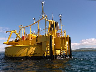
A Single buoy mooring (SrM) is a loading buoy anchored offshore, that serves as a mooring point and interconnect for tankers loading or offloading gas or liquid products. SPMs are the link between geostatic subsea manifold connections and weathervaning tankers. They are capable of handling any tonnage ship, even very large crude carriers (VLCC) where no alternative facility is available.

A drifter is an oceanographic device floating on the surface to investigate ocean currents and other parameters like temperature or salinity. Modern drifters are typically tracked by satellite, often GPS. They are sometimes called Lagrangian drifters since the location of the measurements they make moves with the flow. A major user of drifters is the Global Drifter Program.
The following are considered essential ocean climate variables by the Ocean Observations Panel for Climate (OOPC) that are currently feasible with current observational systems.
A self-locating datum marker buoy (SLDMB) is a drifting surface buoy designed to measure surface ocean currents. The design is based on those of the Coastal Ocean Dynamics Experiment (CODE) and Davis-style oceanographic surface drifters – National Science Foundation (NSF) funded experiments exploring ocean surface currents. The SLDMB was designed for deployment by United States Coast Guard (USCG) vessels in search and rescue (SAR) missions, and is equipped with a Global Positioning Satellite (GPS) sensor that, upon deployment in fresh- or saltwater, transmits its location periodically to the USCG to aid in SAR missions. Additionally, SLDMB are deployed in oceanographic research in order to study surface currents of the ocean. This design has also been utilized by Nomis Connectivity for secure ocean-based communications.
An acoustic release is an oceanographic device for the deployment and subsequent recovery of instrumentation from the sea floor, in which the recovery is triggered remotely by an acoustic command signal.
John Crossley Swallow FRS was an English oceanographer who invented the Swallow float, a scientific drifting bottle based on the messages in bottles that shipwrecked sailors hoped would reach inhabited shores, summoning assistance.
RAFOS floats are submersible devices used to map ocean currents well below the surface. They drift with these deep currents and listen for acoustic "pongs" emitted at designated times from multiple moored sound sources. By analyzing the time required for each pong to reach a float, researchers can pinpoint its position by triangulation. The floats are able to detect the pongs at ranges of hundreds of kilometers because they generally target a range of depths known as the SOFAR channel, which acts as a waveguide for sound. The name "RAFOS" derives from the earlier SOFAR floats, which emitted sounds that moored receivers picked up, allowing real-time underwater tracking. When the transmit and receive roles were reversed, so was the name: RAFOS is SOFAR spelled backward. Listening for sound requires far less energy than transmitting it, so RAFOS floats are cheaper and longer lasting than their predecessors, but they do not provide information in real-time: instead they store it on board, and upon completing their mission, drop a weight, rise to the surface, and transmit the data to shore by satellite.

A current meter is oceanographic device for flow measurement by mechanical, tilt, acoustical or electrical means.
The Tropical Atmosphere Ocean (TAO) project is a major international effort that instrumented the entire tropical Pacific Ocean with approximately 70 deep ocean moorings. The development of the TAO array in 1985 was motivated by the 1982-1983 El Niño event and ultimately designed for the study of year-to-year climate variations related to El Niño and the Southern Oscillation (ENSO). Led by the TAO Project Office of the Pacific Marine Environmental Laboratory (PMEL), the full array of 70 moorings was completed in 1994.
The Research Moored Array for African-Asian-Australian Monsoon Analysis and Prediction (RAMA) is a system of moored observation buoys in the Indian Ocean that collects meteorological and oceanographic data. The data collected by RAMA will greatly enhance the ability of scientists to understand climatic events and predict monsoon events. Climatic and oceanic events in the Indian Ocean affect weather and climate throughout the rest of the world, so RAMA will support weather forecasting and climate research worldwide. Although widely supported internationally, the system has only been partially implemented due to pirate activity off the coast of Somalia.

A float is an oceanographic instrument platform used for making subsurface measurements in the ocean without the need for a ship, propeller, or a person operating it. Floats measure the physical and chemical aspects of the ocean in detail, such as measuring the direction and speed of water or the temperature and salinity. A float will descend to a predetermined depth where it will be neutrally buoyant. Once a certain amount of time has passed, most floats will rise back to the surface by increasing its buoyancy so it can transmit the data it collected to a satellite. A float can collect data while it is neutrally buoyant or moving through the water column. Often, floats are treated as disposable, as the expense of recovering them from remote areas of the ocean is prohibitive; when the batteries fail, a float ceases to function, and drifts at depth until it runs aground or floods and sinks. In other cases, floats are deployed for a short time and recovered.

The Global Drifter Program (GDP), was conceived by Prof. Peter Niiler, with the objective of collecting measurements of surface ocean currents, sea surface temperature and sea-level atmospheric pressure using drifters. It is the principal component of the Global Surface Drifting Buoy Array, a branch of NOAA's Global Ocean Observations and a scientific project of the Data Buoy Cooperation Panel (DBCP). The project originated in February 1979 as part of the TOGA/Equatorial Pacific Ocean Circulation Experiment (EPOCS) and the first large-scale deployment of drifters was in 1988 with the goal of mapping the tropical Pacific Ocean's surface circulation. The current goal of the project is to use 1250 satellite-tracked surface drifting buoys to make accurate and globally dense in-situ observations of mixed layer currents, sea surface temperature, atmospheric pressure, winds and salinity, and to create a system to process the data. Horizontal transports in the oceanic mixed layer measured by the GDP are relevant to biological and chemical processes as well as physical ones.

A fixed-point ocean observatory is an autonomous system of automatic sensors and samplers that continuously gathers data from deep sea, water column and lower atmosphere, and transmits the data to shore in real or near real-time.


