
Salinity is the saltiness or amount of salt dissolved in a body of water, called saline water. It is usually measured in g/L or g/kg.

Oceanography, also known as oceanology, sea science, ocean science, and marine science, is the scientific study of the ocean, including its physics, chemistry, biology, and geology.

An oceanographic water mass is an identifiable body of water with a common formation history which has physical properties distinct from surrounding water. Properties include temperature, salinity, chemical - isotopic ratios, and other physical quantities which are conservative flow tracers. Water mass is also identified by its non-conservative flow tracers such as silicate, nitrate, oxygen, and phosphate.
The World Ocean Database Project, or WOD, is a project established by the Intergovernmental Oceanographic Commission (IOC). The project leader was Sydney Levitus, who was also director of the International Council for Science (ICSU) World Data Center (WDC) for Oceanography, Silver Spring. Sydney Levitus retired in 2013. In recognition of the success of the IOC Global Oceanographic Data Archaeological and Rescue Project, a proposal was presented at the 16th Session of the Committee on International Oceanographic Data and Information Exchange (IODE), which was held in Lisbon, Portugal, in October–November 2000, to establish the World Ocean Database Project. This project is intended to stimulate international exchange of modern oceanographic data and encourage the development of regional oceanographic databases as well as the implementation of regional quality control procedures. This new Project was endorsed by the IODE at the conclusion of the Portugal meeting, and the IOC subsequently approved this project in June 2001.

Argo is an international programme for researching the ocean. It uses profiling floats to observe temperature, salinity and currents. Recently it has observed bio-optical properties in the Earth's oceans. It has been operating since the early 2000s. The real-time data it provides support climate and oceanographic research. A special research interest is to quantify the ocean heat content (OHC). The Argo fleet consists of almost 4000 drifting "Argo floats" deployed worldwide. Each float weighs 20–30 kg. In most cases probes drift at a depth of 1000 metres. Experts call this the parking depth. Every 10 days, by changing their buoyancy, they dive to a depth of 2000 metres and then move to the sea-surface. As they move they measure conductivity and temperature profiles as well as pressure. Scientists calculate salinity and density from these measurements. Seawater density is important in determining large-scale motions in the ocean.
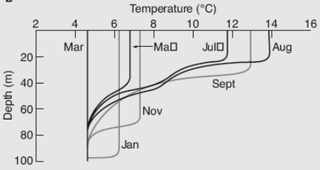
The oceanic or limnological mixed layer is a layer in which active turbulence has homogenized some range of depths. The surface mixed layer is a layer where this turbulence is generated by winds, surface heat fluxes, or processes such as evaporation or sea ice formation which result in an increase in salinity. The atmospheric mixed layer is a zone having nearly constant potential temperature and specific humidity with height. The depth of the atmospheric mixed layer is known as the mixing height. Turbulence typically plays a role in the formation of fluid mixed layers.
The World Ocean Circulation Experiment (WOCE) was a component of the international World Climate Research Program, and aimed to establish the role of the World Ocean in the Earth's climate system. WOCE's field phase ran between 1990 and 1998, and was followed by an analysis and modeling phase that ran until 2002. When the WOCE was conceived, there were three main motivations for its creation. The first of these is the inadequate coverage of the World Ocean, specifically in the Southern Hemisphere. Data was also much more sparse during the winter months than the summer months, and there was—and still is to some extent—a critical need for data covering all seasons. Secondly, the data that did exist was not initially collected for studying ocean circulation and was not well suited for model comparison. Lastly, there were concerns involving the accuracy and reliability of some measurements. The WOCE was meant to address these problems by providing new data collected in ways designed to "meet the needs of global circulation models for climate prediction."
The Global Ocean Data Analysis Project (GLODAP) is a synthesis project bringing together oceanographic data, featuring two major releases as of 2018. The central goal of GLODAP is to generate a global climatology of the World Ocean's carbon cycle for use in studies of both its natural and anthropogenically forced states. GLODAP is funded by the National Oceanic and Atmospheric Administration, the U.S. Department of Energy, and the National Science Foundation.

The Bermuda Atlantic Time-series Study (BATS) is a long-term oceanographic study by the Bermuda Institute of Ocean Sciences (BIOS). Based on regular research cruises, it samples an area of the western Atlantic Ocean nominally at the coordinates 31°40′N64°10′W. The cruise programme routinely samples physical properties such as ocean temperature and salinity, but focuses on variables of biological or biogeochemical interest including: nutrients, dissolved inorganic carbon, oxygen, HPLC of pigments, primary production and sediment trap flux. The BATS cruises began in 1988 but are supplemented by biweekly Hydrostation "S" cruises to a neighbouring location that began in 1954. The data collected by these cruises are available online.
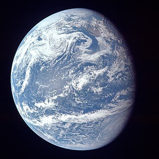
The ocean is the body of salt water that covers approximately 70.8% of Earth. In English, the term ocean also refers to any of the large bodies of water into which the world ocean is conventionally divided. The following names describe five different areas of the ocean: Pacific, Atlantic, Indian, Antarctic/Southern, and Arctic. The ocean contains 97% of Earth's water and is the primary component of Earth's hydrosphere and is thereby essential to life on Earth. The ocean influences climate and weather patterns, the carbon cycle, and the water cycle by acting as a huge heat reservoir.
The following are considered ocean essential climate variables (ECVs) by the Ocean Observations Panel for Climate (OOPC) that are currently feasible with current observational systems.
Ocean reanalysis is a method of combining historical ocean observations with a general ocean model driven by historical estimates of surface winds, heat, and freshwater, by way of a data assimilation algorithm to reconstruct historical changes in the state of the ocean.

CORA is a global oceanographic temperature and salinity dataset produced and maintained by the French institute IFREMER. Most of those data are real-time data coming from different types of platforms such as research vessels, profilers, underwater gliders, drifting buoys, moored buoys, sea mammals and ships of opportunity.

SeaDataNet is an international project of oceanography. Its main goal is to enable the scientific community to access historical datasets owned by national data centers.
The Tropical Atmosphere Ocean (TAO) project is a major international effort that instrumented the entire tropical Pacific Ocean, with approximately 70 deep ocean moorings. The development of the TAO array in 1985 was motivated by the 1982-1983 El Niño event and ultimately designed for the study of year-to-year climate variations related to El Niño and the Southern Oscillation (ENSO). Led by the TAO Project Office of the Pacific Marine Environmental Laboratory (PMEL), the full array of 70 moorings was completed in 1994.
The neutral density or empirical neutral density is a density variable used in oceanography, introduced in 1997 by David R. Jackett and Trevor McDougall. It is a function of the three state variables and the geographical location. It has the typical units of density (M/V). Isosurfaces of form “neutral density surfaces”, which are closely aligned with the "neutral tangent plane". It is widely believed, although this has yet to be rigorously proven, that the flow in the deep ocean is almost entirely aligned with the neutral tangent plane, and strong lateral mixing occurs along this plane vs weak mixing across this plane . These surfaces are widely used in water mass analyses. Neutral density is a density variable that depends on the particular state of the ocean, and hence is also a function of time, though this is often ignored. In practice, its construction from a given hydrographic dataset is achieved by means of a computational code, that contains the computational algorithm developed by Jackett and McDougall. Use of this code is currently restricted to the present day ocean.

Global surface temperature (GST) is the average temperature of Earth's surface. More precisely, it is the weighted average of the temperatures over the ocean and land. The former is also called sea surface temperature and the latter is called surface air temperature. Temperature data comes mainly from weather stations and satellites. To estimate data in the distant past, proxy data can be used for example from tree rings, corals, and ice cores. Observing the rising GST over time is one of the many lines of evidence supporting the scientific consensus on climate change, which is that human activities are causing climate change. Alternative terms for the same thing are global mean surface temperature (GMST) or global average surface temperature.
The Simple Ocean Data Assimilation (SODA) analysis is an oceanic reanalysis data set consisting of gridded state variables for the global ocean, as well as several derived fields. SODA was developed in the 1990s as a collaborative project between the Department of Atmospheric and Oceanic Science at the University of Maryland and the Department of Oceanography at Texas A&M University with the goal of providing an improved estimate of ocean state from those based solely on observations or numerical simulations. Since its first release there have been several updates, the most recent of which extends from 1958 to 2008, as well as a “beta release” of a long-term reanalysis for 1871–2008.

The Global Drifter Program (GDP) was conceived by Prof. Peter Niiler, with the objective of collecting measurements of surface ocean currents, sea surface temperature and sea-level atmospheric pressure using drifters. It is the principal component of the Global Surface Drifting Buoy Array, a branch of NOAA's Global Ocean Observations and a scientific project of the Data Buoy Cooperation Panel (DBCP). The project originated in February 1979 as part of the TOGA/Equatorial Pacific Ocean Circulation Experiment (EPOCS) and the first large-scale deployment of drifters was in 1988 with the goal of mapping the tropical Pacific Ocean's surface circulation. The current goal of the project is to use 1250 satellite-tracked surface drifting buoys to make accurate and globally dense in-situ observations of mixed layer currents, sea surface temperature, atmospheric pressure, winds and salinity, and to create a system to process the data. Horizontal transports in the oceanic mixed layer measured by the GDP are relevant to biological and chemical processes as well as physical ones.
The Geochemical Ocean Sections Study (GEOSECS) was a global survey of the three-dimensional distributions of chemical, isotopic, and radiochemical tracers in the ocean. A key objective was to investigate the deep thermohaline circulation of the ocean, using chemical tracers, including radiotracers, to establish the pathways taken by this.
 Annual mean sea surface temperature (WOA 2009)
 Annual mean sea surface salinity (WOA 2009)
 Annual mean sea surface dissolved oxygen (WOA 2009)
 Annual mean sea surface phosphate (WOA 2009)
 Annual mean sea surface silicic acid (WOA 2009)
 Annual mean sea surface nitrate (WOA 2009)
 Annual mean apparent oxygen utilization at 1000 m depth (WOA 2009)


