
The National Oceanic and Atmospheric Administration is a Washington, D.C.–based scientific and regulatory agency within the United States Department of Commerce, a United States federal government department. The agency is charged with forecasting weather, monitoring oceanic and atmospheric conditions, charting the seas, conducting deep sea exploration, and managing fishing and protection of marine mammals and endangered species in the U.S. exclusive economic zone.
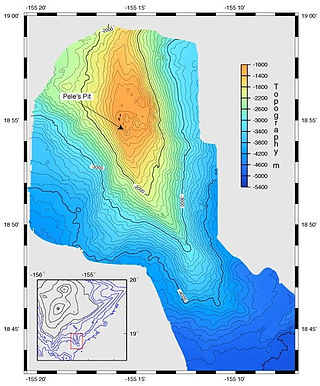
A bathymetric chart is a type of isarithmic map that depicts the submerged topography and physiographic features of ocean and sea bottoms. Their primary purpose is to provide detailed depth contours of ocean topography as well as provide the size, shape and distribution of underwater features. Topographic maps display elevation above ground and are complementary to bathymetric charts. Charts use a series of lines and points at equal intervals to showcase depth or elevation. A closed shape with increasingly smaller shapes inside of it can indicate an ocean trench or a seamount, or underwater mountain, depending on whether the depths increase or decrease going inward.
The National Ocean Service (NOS) is an office within the U.S. Department of Commerce, National Oceanic and Atmospheric Administration (NOAA). It is responsible for preserving and enhancing the nation's coastal resources and ecosystems along approximately 95,000 miles (153,000 km) of shoreline, that is bordering 3,500,000 square miles (9,100,000 km2) of coastal, Great Lakes and ocean waters. Its mission is to "provide science-based solutions through collaborative partnerships to address evolving economic, environmental, and social pressures on our oceans and coasts." The office works with partnered agencies to ensure that ocean and coastal areas are safe, healthy, and productive. It`s projects focus on working to ensure safe and efficient marine transportation, promoting the protection of coastal communities, conserving marine and coastal places. It employs 1,700 scientists, natural resource managers, and specialists in many different fields. The National Ocean Service was previously known as the National Ocean Survey until it was renamed in 1983.
The United States National Geophysical Data Center (NGDC) provided scientific stewardship, products and services for geophysical data describing the solid earth, marine, and solar-terrestrial environment, as well as earth observations from space. In 2015, NGDC was merged with the National Climatic Data Center (NCDC) and the National Oceanographic Data Center (NODC) into the National Centers for Environmental Information (NCEI).
The Global Oceanographic Data Archaeology and Rescue Project, or GODAR Project was established to increase the volume of historical oceanographic data available to climate change and other researchers. The project attempts to locate ocean profile and plankton data sets not yet in digital form, digitizes these data, and ensures their submission to national data centers and the World Data Center system (WDC). In addition, data on electronic media that are at risk of loss due to media degradation are also candidates for rescue.

The Global Temperature and Salinity Profile Programme (GTSPP) is a cooperative international project that seeks to develop and maintain a global ocean Temperature-Salinity resource with up-to-date and high quality data.

Bathymetry is the study of underwater depth of ocean floors, lake floors, or river floors. In other words, bathymetry is the underwater equivalent to hypsometry or topography. The first recorded evidence of water depth measurements are from Ancient Egypt over 3000 years ago. Bathymetric charts, are typically produced to support safety of surface or sub-surface navigation, and usually show seafloor relief or terrain as contour lines and selected depths (soundings), and typically also provide surface navigational information. Bathymetric maps may also use a Digital Terrain Model and artificial illumination techniques to illustrate the depths being portrayed. The global bathymetry is sometimes combined with topography data to yield a global relief model. Paleobathymetry is the study of past underwater depths.
The World Ocean Database Project, or WOD, is a project established by the Intergovernmental Oceanographic Commission (IOC). The project leader is Sydney Levitus who is director of the International Council for Science (ICSU) World Data Center (WDC) for Oceanography, Silver Spring. In recognition of the success of the IOC Global Oceanographic Data Archaeological and Rescue Project, a proposal was presented at the 16th Session of the Committee on International Oceanographic Data and Information Exchange (IODE), which was held in Lisbon, Portugal, in October–November 2000, to establish the World Ocean Database Project. This project is intended to stimulate international exchange of modern oceanographic data and encourage the development of regional oceanographic databases as well as the implementation of regional quality control procedures. This new Project was endorsed by the IODE at the conclusion of the Portugal meeting, and the IOC subsequently approved this project in June 2001.

The Index to Marine & Lacustrine Geological Samples is a collaboration between multiple institutions and agencies that operate geological sample repositories. The purpose of the database is to help researchers locate sea floor and lakebed cores, grabs, dredges, and drill samples in their collections.
The Carbon Dioxide Information Analysis Center (CDIAC) was an organization within the United States Department of Energy that had the primary responsibility for providing the US government and research community with global warming data and analysis as it pertains to energy issues. The CDIAC, and its subsidiary the World Data Center for Atmospheric Trace Gases, focused on obtaining, evaluating and distributing data related to climate change and greenhouse gas emissions.

The National Environmental Satellite, Data, and Information Service (NESDIS) was created by the National Oceanic and Atmospheric Administration (NOAA) to operate and manage the United States environmental satellite programs, and manage the data gathered by the National Weather Service and other government agencies and departments.
The following are considered ocean essential climate variables (ECVs) by the Ocean Observations Panel for Climate (OOPC) that are currently feasible with current observational systems.

The Department of Commerce Gold Medal is the highest honor award of the United States Department of Commerce. Since 1949, the Department of Commerce Gold Medal is presented by the Secretary of Commerce for distinguished performance. The award may be presented to an individual, group, or organization in the Commerce Department for extraordinary, noble, or prestigious contributions that impact the mission of the department and/or one or more operating units, which reflects favorable on the department.
The 1293 Kamakura earthquake in Japan occurred at about 06:00 local time on 27 May 1293. It had an estimated magnitude of 7.1–7.5 and triggered a tsunami. The estimated death toll was 23,024. It occurred during the Kamakura period, and the city of Kamakura was seriously damaged.
The NOAA Central Library is the flagship library of the National Oceanic and Atmospheric Administration’s (NOAA) network of over 20 research libraries. It is also a selective federal depository library for United States federal government publications.[6]
The National Centers for Environmental Information (NCEI) is a U.S. government agency that manages one of the world’s largest archives of atmospheric, coastal, geophysical, and oceanic data. The current director is Derek Arndt.
The area around Constantinople was affected by a major earthquake in AD 447. It caused serious damage to the recently completed Theodosian Walls in Constantinople, destroying 57 towers and large stretches of the walls. The historical records contain no mention of casualties directly associated with this earthquake, although many thousands of people were reported to have died in the aftermath due to starvation and a "noxious smell".
The 1761 Lisbon earthquake and its subsequent tsunami occurred in the north Atlantic Ocean and south of the Iberian Peninsula. This violent shock which struck just after noon on 31 March 1761, was felt across many parts of Western Europe. Its direct effects were even observed far north in Scotland and Amsterdam, and to the south in the Canary Islands of Spain. The estimated surface-wave magnitude 8.5 event was the largest in the region, and the most significant earthquake in Europe since the Great Lisbon earthquake of 1755.
During April 1819, the area around Copiapó in northern Chile was struck by a sequence of earthquakes over a period of several days. The largest of these earthquakes occurred on 11 April at about 15:00 local time, with an estimated magnitude of 8.5. The other two events, on 3 April between 08:00 and 09:00 local time and on 4 April at 16:00 local time, are interpreted as foreshocks to the mainshock on 11 April. The mainshock triggered a tsunami that affected 800 km of coastline and was also recorded at Hawaii. The city of Copiapó was devastated.

