The Challenger Deep is the deepest known point of the seabed in the Earth's hydrosphere, with a depth of 10,902 to 10,929 m by direct measurement from deep-diving submersibles, remotely operated underwater vehicles, and benthic landers and (sometimes) slightly more by sonar bathymetry.

The Integrated Taxonomic Information System (ITIS) is an American partnership of federal agencies designed to provide consistent and reliable information on the taxonomy of biological species. ITIS was originally formed in 1996 as an interagency group within the US federal government, involving several US federal agencies, and has now become an international body, with Canadian and Mexican government agencies participating. The database draws from a large community of taxonomic experts. Primary content staff are housed at the Smithsonian National Museum of Natural History and IT services are provided by a US Geological Survey facility in Denver. The primary focus of ITIS is North American species, but many biological groups exist worldwide and ITIS collaborates with other agencies to increase its global coverage.
The National Oceanographic Data Center (NODC) was one of the national environmental data centers operated by the National Oceanic and Atmospheric Administration (NOAA) of the U.S. Department of Commerce. The main NODC facility was located in Silver Spring, Maryland and was made up of five divisions. The NODC also had field offices collocated with major government or academic oceanographic laboratories in Stennis Space Center, MS; Miami, FL; La Jolla, San Diego, California; Seattle, WA; Austin, Texas; Charleston, South Carolina; Norfolk, Virginia; and Honolulu, Hawaii. In 2015, NODC was merged with the National Climatic Data Center and the National Geophysical Data Center into the National Centers for Environmental Information (NCEI).
The World Ocean Database Project, or WOD, is a project established by the Intergovernmental Oceanographic Commission (IOC). The project leader is Sydney Levitus who is director of the International Council for Science (ICSU) World Data Center (WDC) for Oceanography, Silver Spring. In recognition of the success of the IOC Global Oceanographic Data Archaeological and Rescue Project, a proposal was presented at the 16th Session of the Committee on International Oceanographic Data and Information Exchange (IODE), which was held in Lisbon, Portugal, in October–November 2000, to establish the World Ocean Database Project. This project is intended to stimulate international exchange of modern oceanographic data and encourage the development of regional oceanographic databases as well as the implementation of regional quality control procedures. This new Project was endorsed by the IODE at the conclusion of the Portugal meeting, and the IOC subsequently approved this project in June 2001.

A Small Waterplane Area Twin Hull, better known by the acronym SWATH, is a twin-hull ship design that minimizes hull cross section area at the sea's surface. Minimizing the ship's volume near the surface area of the sea, where wave energy is located, maximizes a vessel's stability, even in high seas and at high speeds. The bulk of the displacement necessary to keep the ship afloat is located beneath the waves, where it is less affected by wave action. Wave excitation drops exponentially as depth increases, so wave action normally does not affect a submerged submarine at all. Placing the majority of a ship's displacement under the waves is similar in concept to creating a ship that rides atop twin submarines.

The United Kingdom Hydrographic Office (UKHO) is the UK's agency for providing hydrographic and marine geospatial data to mariners and maritime organisations across the world. The UKHO is a trading fund of the Ministry of Defence (MoD) and is located in Taunton, Somerset, with a workforce of approximately 900 staff.

A research vessel is a ship or boat designed, modified, or equipped to carry out research at sea. Research vessels carry out a number of roles. Some of these roles can be combined into a single vessel but others require a dedicated vessel. Due to the demanding nature of the work, research vessels are often constructed around an icebreaker hull, allowing them to operate in polar waters.

INS Darshak (J21) is a hydrographic survey ship in the Indian Navy, under the Eastern Naval Command.

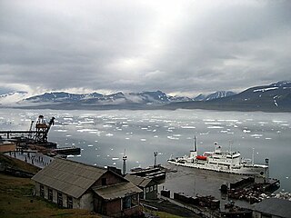
Professor Molchanov is a Russian ice-strengthened oceanographic research vessel. The ship was built in Finland in 1983 and is now converted to passenger duties for the expedition cruise market.

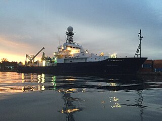
R/V Roger Revelle is an auxiliary general-purpose research vessel (AGOR) operated by Scripps Institution of Oceanography under charter agreement with Office of Naval Research as part of the University-National Oceanographic Laboratory System (UNOLS) fleet.
Behr Paima is a hydrographic survey and Research vessel owned by Pakistan Navy. Her keel was laid on 16 February 1982 and was launched on 7 July 1982 in Japan. The ship was handed over to Pakistan Navy on 27 December, same year. The ship was equipped with most modern surveying systems of the time. The hydrographic systems have been upgraded since then from time to time and hence are parallel with modern trends and techniques available in the world. Most of the oceanographic equipments are, however, of the original outfit.

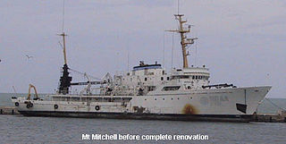
NOAAS Mount Mitchell was an American survey vessel in commission in the National Oceanic and Atmospheric Administration from 1970 to 1995. Prior to her NOAA career, she was in commission in the United States Coast and Geodetic Survey as USC&GS Mount Mitchell from 1968 to 1970. In 2003, she returned to service as the private research ship R/V Mt. Mitchell.
Gyre (T-AGOR-21), best known as R/V Gyre, was the lead ship of her class of oceanographic research ships acquired by the U.S. Navy in 1973 for assignment to the University-National Oceanographic Laboratory System (UNOLS) fleet of Navy owned ships. Gyre was operated by the Texas A&M University School of Oceanography as part of the Navy owned UNOLS fleet until stricken 17 August 1992 and transferred to the university under a program transferring ships to states, schools and other public institutions. The university operated the ship until sale in December 2005.
Lynne Talley is a physical oceanographer at Scripps Institution of Oceanography known for her research into the large-scale circulation of water masses in the global ocean.

The Japan Agency for Marine-Earth Science and Technology, or JAMSTEC (海洋機構), is a Japanese national research institute for marine-earth science and technology. It was founded as Japan Marine Science and Technology Center (海洋科学技術センター) in October 1971, and became an Independent Administrative Institution administered by the Ministry of Education, Culture, Sports, Science and Technology (MEXT) in April 2004.
SeaDataNet is an international project of oceanography. Its main goal is to enable the scientific community to access historical datasets owned by national data centers.
The neutral density or empirical neutral density is a density variable used in oceanography, introduced in 1997 by David R. Jackett and Trevor McDougall. It is a function of the three state variables and the geographical location. It has the typical units of density (M/V). Isosurfaces of form “neutral density surfaces”, which are closely aligned with the "neutral tangent plane". It is widely believed, although this has yet to be rigorously proven, that the flow in the deep ocean is almost entirely aligned with the neutral tangent plane, and strong lateral mixing occurs along this plane vs weak mixing across this plane . These surfaces are widely used in water mass analyses. Neutral density is a density variable that depends on the particular state of the ocean, and hence is also a function of time, though this is often ignored. In practice, its construction from a given hydrographic dataset is achieved by means of a computational code, that contains the computational algorithm developed by Jackett and McDougall. Use of this code is currently restricted to the present day ocean.

R/V Ocean Starr is an American research vessel. She was in the United States Fish and Wildlife Service's Bureau of Commercial Fisheries fleet from 1966 to 1970 as US FWS David Starr Jordan. The ship later served under the National Oceanic and Atmospheric Administration (NOAA) from 1970 to 2010.

Maritime call signs are call signs assigned as unique identifiers to ships and boats. All radio transmissions must be individually identified by the call sign. Merchant and naval vessels are assigned call signs by their national licensing authorities.

USNS Chauvenet (T-AGS-29) was a coastal survey ship laid down on 24 May 1967, at Upper Clyde Shipbuilding Corp., Glasgow, Scotland. The ship was the second survey ship, Chauvenet (AGS-11) being the first, named for William Chauvenet (1820-1870). He was instrumental in the founding of the United States Naval Academy at Annapolis, MD. The mathematics department of the US Naval Academy in Annapolis was founded by Chauvenet and is housed in Chauvenet Hall. Chauvenet was launched on 13 May 1968, delivered to the US Navy, 13 November 1970 and placed in service with the Military Sealift Command (MSC) as USNS Chauvenet (T-AGS-29). The ship conducted coastal hydrographic and topographic surveys under the technical direction of the Oceanographer of the Navy through the U.S. Naval Oceanographic Office (NAVOCEANO). The ship was assigned to the Pacific for surveys, sister ship Harkness (T-AGS-32) was assigned Atlantic duties, doing so until inactivated in November 1992.