Related Research Articles

Physical oceanography is the study of physical conditions and physical processes within the ocean, especially the motions and physical properties of ocean waters.
The World Climate Research Programme (WCRP) is an international programme that helps to coordinate global climate research. The WCRP was established in 1980, under the joint sponsorship of the World Meteorological Organization (WMO) and the International Council for Science (ICSU), and has also been sponsored by the Intergovernmental Oceanographic Commission (IOC) of UNESCO since 1993.
The Intergovernmental Oceanographic Commission of UNESCO (IOC/UNESCO) was established by resolution 2.31 adopted by the General Conference of the United Nations Educational, Scientific and Cultural Organization (UNESCO). It first met in Paris at UNESCO Headquarters from 19 to 27 October 1961. Initially, 40 States became members of the commission. The IOC assists governments to address their individual and collective ocean and coastal management needs, through the sharing of knowledge, information and technology as well as through the co-ordination of programs and building capacity in ocean and coastal research, observations and services.
The Tropical Ocean Global Atmosphere program (TOGA) was a ten-year study (1985–1994) of the World Climate Research Programme (WCRP) aimed specifically at the prediction of climate phenomena on time scales of months to years.

Jason-1 was a satellite altimeter oceanography mission. It sought to monitor global ocean circulation, study the ties between the ocean and the atmosphere, improve global climate forecasts and predictions, and monitor events such as El Niño and ocean eddies. Jason-1 was launched in 2001 and it was followed by OSTM/Jason-2 in 2008, and Jason-3 in 2016 – the Jason satellite series. Jason-1 was launched alongside the TIMED spacecraft.

A tsunami warning system (TWS) is used to detect tsunamis in advance and issue the warnings to prevent loss of life and damage to property. It is made up of two equally important components: a network of sensors to detect tsunamis and a communications infrastructure to issue timely alarms to permit evacuation of the coastal areas. There are two distinct types of tsunami warning systems: international and regional. When operating, seismic alerts are used to instigate the watches and warnings; then, data from observed sea level height are used to verify the existence of a tsunami. Other systems have been proposed to augment the warning procedures; for example, it has been suggested that the duration and frequency content of t-wave energy is indicative of an earthquake's tsunami potential.

A tide gauge is a device for measuring the change in sea level relative to a vertical datum. It is also known as a mareograph, marigraph, and sea-level recorder When applied to freshwater continental water bodies, the instrument may also be called a limnimeter.
The Global Earth Observation System of Systems (GEOSS) was built by the Group on Earth Observations (GEO) on the basis of a 10-Year Implementation Plan running from 2005 to 2015. GEOSS seeks to connect the producers of environmental data and decision-support tools with the end users of these products, with the aim of enhancing the relevance of Earth observations to global issues. GEOSS aims to produce a global public infrastructure that generates comprehensive, near-real-time environmental data, information and analyses for a wide range of users. The Secretariat Director of Geoss is Barbara Ryan.
The National Oceanography Centre (NOC) is a marine science research and technology institution based on two sites in Southampton and Liverpool, England. It is the UK’s largest institution for integrated sea level science, coastal and deep ocean research and technology development. The Centre was established to promote cooperation with institutions across the UK marine science community, to better address key issues including sea level change, the ocean's role is climate change, computer simulation of the ocean's behaviour, and the long term monitoring and future of the Arctic Circle.
The Global Climate Observing System (GCOS) was established in 1992 as an outcome of the Second World Climate Conference, to ensure that the observations and information needed to address climate-related issues are obtained and made available to all potential users. The GCOS is co-sponsored by the World Meteorological Organization (WMO), the Intergovernmental Oceanographic Commission (IOC) of UNESCO, the United Nations Environment Programme (UNEP), and the International Council for Science (ICSU). In order to assess and monitor the adequacy of in-situ observation networks as well as satellite-based observing systems, GCOS regularly reports on the adequacy of the current climate observing system to the United Nations Framework Convention on Climate Change (UNFCCC), and thereby identifies the needs of the current climate observing system.

The former Proudman Oceanographic Laboratory (POL) is based in Brownlow Street, Liverpool, England. In April 2010, POL merged with the National Oceanography Centre, Southampton (NOCS) to form the National Oceanography Centre. The Liverpool laboratory's scientific research focuses on oceanography encompassing global sea-levels and geodesy, numerical modelling of continental shelf seas and coastal sediment processes. This research alongside activities of surveying, monitoring, data management and forecasting provides strategic support for the wider mission of the Natural Environment Research Council.
The World Ocean Circulation Experiment (WOCE) was a component of the international World Climate Research Program, and aimed to establish the role of the World Ocean in the Earth's climate system. WOCE's field phase ran between 1990 and 1998, and was followed by an analysis and modeling phase that ran until 2002. When the WOCE was conceived, there were three main motivations for its creation. The first of these is the inadequate coverage of the World Ocean, specifically in the Southern Hemisphere. Data was also much more sparse during the winter months than the summer months, and there was—and still is to some extent—a critical need for data covering all seasons. Secondly, the data that did exist was not initially collected for studying ocean circulation and was not well suited for model comparison. Lastly, there were concerns involving the accuracy and reliability of some measurements. The WOCE was meant to address these problems by providing new data collected in ways designed to "meet the needs of global circulation models for climate prediction."
The Global Ocean Observing System (GOOS) is a global system for sustained observations of the ocean comprising the oceanographic component of the Global Earth Observing System of Systems (GEOSS). GOOS is administrated by the Intergovernmental Oceanographic Commission (IOC), and joins the Global Climate Observing System, GCOS, and Global Terrestrial Observing System, GTOS, as fundamental building blocks of the GEOSS.
Indian National Center for Ocean Information Services (INCOIS) is an autonomous organization of the Government of India, under the Ministry of Earth Sciences, located in Pragathi Nagar, Hyderabad. ESSO-INCOIS was established as an autonomous body in 1998 under the Ministry of Earth Sciences (MoES) and is a unit of the Earth System Science Organization (ESSO). ESSO- INCOIS is mandated to provide the best possible ocean information and advisory services to society, industry, government agencies and the scientific community through sustained ocean observations and constant improvements through systematic and focussed research.
The British Oceanographic Data Centre (BODC) is a national facility for looking after and distributing data about the marine environment. BODC is the designated marine science data centre for the United Kingdom and part of the National Oceanography Centre (NOC) — primarily at its facility in Liverpool, with small number of its staff in Southampton. The centre provides a resource for science, education and industry, as well as the general public.
The following are considered ocean essential climate variables (ECVs) by the Ocean Observations Panel for Climate (OOPC) that are currently feasible with current observational systems.

The Prediction and Research Moored Array in the Atlantic (PIRATA) is a system of moored observation buoys in the tropical Atlantic Ocean which collect meteorological and oceanographic data. The data collected by the PIRATA array helps scientists to better understand climatic events in the Tropical Atlantic and to improve weather forecasting and climate research worldwide. Climatic and oceanic events in the tropical Atlantic, such as the Tropical Atlantic SST Dipole affect rainfall and climate in both West Africa and Northeast Brazil. The northern tropical Atlantic is also a major formation area for hurricanes affecting the West Indies and the United States. Alongside the RAMA array in the Indian Ocean and the TAO/TRITON network in the Pacific Ocean, PIRATA forms part of the worldwide system of tropical ocean observing buoys.

The Tuvalu Meteorological Service (TMS) is the principal meteorological observatory of Tuvalu and is responsible for providing weather services to the islands of Tuvalu. A meteorological office was established on Funafuti at the time the islands of Tuvalu were administered as parts of the Gilbert and Ellice Islands colony of the United Kingdom. The meteorological office is now an agency of the government of Tuvalu.
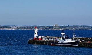
Newlyn Tidal Observatory is a grade II listed tide gauge hut on the South Pier in Newlyn, Cornwall in England. Measurements of sea level taken at the observatory between 1915 and 1921 were used to define the reference level, Ordnance Datum Newlyn, for height measurement on the British mainland. The tide gauge has collected over 100 years of observations which has significantly contributed to studies in sea level science.
David Pugh was a British marine scientist and academic. He founded the Global Sea Level Observing System, was President of the Intergovernmental Oceanographic Commission of UNESCO, Director of the Permanent Service for Mean Sea Level, and emeritus fellow of the UK National Oceanography Centre.
References
- ↑ "In memoriam of David Thomas Pugh". National Oceanography Centre . 12 August 2022. Archived from the original on 28 May 2023. Retrieved 28 October 2023.
- ↑ "Global Sea Level Observing System (GLOSS)".

