Related Research Articles

Geodesy is the Earth science of accurately measuring and understanding Earth's geometric shape, orientation in space and gravitational field. The field also incorporates studies of how these properties change over time and equivalent measurements for other planets. Geodynamical phenomena include crustal motion, tides and polar motion, which can be studied by designing global and national control networks, applying space and terrestrial techniques and relying on datums and coordinate systems.

Tides are the rise and fall of sea levels caused by the combined effects of the gravitational forces exerted by the Moon and the Sun, and the rotation of the Earth.

Mean sea level (MSL) is an average level of the surface of one or more of Earth's bodies of water from which heights such as elevation may be measured. The global MSL is a type of vertical datum – a standardised geodetic datum – that is used, for example, as a chart datum in cartography and marine navigation, or, in aviation, as the standard sea level at which atmospheric pressure is measured to calibrate altitude and, consequently, aircraft flight levels. A common and relatively straightforward mean sea-level standard is instead the midpoint between a mean low and mean high tide at a particular location.
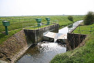
A stream gauge, streamgage or stream gauging station is a location used by hydrologists or environmental scientists to monitor and test terrestrial bodies of water. Hydrometric measurements of water level surface elevation ("stage") and/or volumetric discharge (flow) are generally taken and observations of biota and water quality may also be made. The location of gauging stations are often found on topographical maps. Some gauging stations are highly automated and may include telemetry capability transmitted to a central data logging facility.

Bathymetry is the study of underwater depth of ocean floors or lake floors. In other words, bathymetry is the underwater equivalent to hypsometry or topography. The name comes from Greek βαθύς (bathus), "deep", and μέτρον (metron), "measure". Bathymetric charts are typically produced to support safety of surface or sub-surface navigation, and usually show seafloor relief or terrain as contour lines and selected depths (soundings), and typically also provide surface navigational information. Bathymetric maps may also use a Digital Terrain Model and artificial illumination techniques to illustrate the depths being portrayed. The global bathymetry is sometimes combined with topography data to yield a Global Relief Model. Paleobathymetry is the study of past underwater depths.
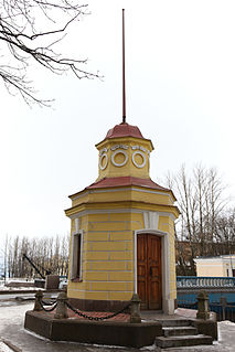
A tide gauge is a device for measuring the change in sea level relative to a vertical datum. It its also known as mareograph, marigraph, sea-level recorder and limnimeter.
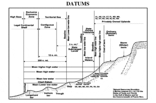
A chart datum is the water level that depths displayed on a nautical chart are measured from. A chart datum is generally derived from some phase of the tide. Common chart datums are lowest astronomical tide and mean lower low water. In non-tidal areas, e.g. the Baltic Sea, mean sea level (MSL) is used.

In the British Isles, an ordnance datum or OD is a vertical datum used by an ordnance survey as the basis for deriving altitudes on maps. A spot height may be expressed as AOD for "above ordnance datum". Usually mean sea level (MSL) is used for the datum. In particular:
The National Oceanography Centre (NOC) is a marine science research and technology institution based on two sites in Southampton and Liverpool, United Kingdom. It is the UK’s largest institution for integrated sea level science, coastal and deep ocean research and technology development.
Established in 1985, The Global Sea Level Observing System (GLOSS) is an Intergovernmental Oceanographic Commission program whose purpose is to measure sea level globally for long-term climate change studies. The program's purpose has changed since the 2004 Indian Ocean earthquake and the program now collects real time measurements of sea level. The project is currently upgrading the over 290 stations it currently runs, so that they can send real time data via satellite to newly set up national tsunami centres. They are also fitting the stations with solar panels so they can continue to operate even if the mains power supply is interrupted by severe weather. The Global Sea Level Observing System does not compete with Deep-ocean Assessment and Reporting of Tsunamis as most GLOSS transducers are located close to land masses while DART's transducers are far out in the ocean.
The Australian Height Datum was introduced in 1971 as the official vertical datum for Australia, and thereby serves as the benchmark to which all height measurements are referred. The Australian Height Datum is an amalgamation of decades of spirit levelling work conducted by numerous state and territory authorities across the country, and was corrected to align with the mean sea level observations of thirty tide gauges positioned around the entire coastline. While it still remains the published vertical datum for all surveying and engineering operations performed throughout Australia, newer technologies have uncovered numerous deficiencies, offsets and distortions within the Australian Height Datum, leading to discussions about defining a new Australian vertical datum.

The former Proudman Oceanographic Laboratory (POL) is based in Brownlow Street, Liverpool, England. In April 2010, POL merged with the National Oceanography Centre, Southampton (NOCS) to form the National Oceanography Centre. The Liverpool laboratory's scientific research focuses on oceanography encompassing global sea-levels and geodesy, numerical modelling of continental shelf seas and coastal sediment processes. This research alongside activities of surveying, monitoring, data management and forecasting provides strategic support for the wider mission of the Natural Environment Research Council.

The National Geodetic Vertical Datum of 1929 is the official name since 1973 of the vertical datum established for vertical control surveying in the United States of America by the General Adjustment of 1929. Originally known as Sea Level Datum of 1929, NGVD 29 was determined and published by the National Geodetic Survey and used to measure the elevation of a point above and depression below mean sea level (MSL).

OSTM/Jason-2, or Ocean Surface Topography Mission/Jason-2 satellite, was an international Earth observation satellite altimeter joint mission for sea surface height measurements between NASA and CNES. It was the third satellite in a series started in 1992 by the NASA/CNES TOPEX/Poseidon mission and continued by the NASA/CNES Jason-1 mission launched in 2001.
The following outline is provided as an overview of and introduction to Oceanography.
A vertical datum, altimetric datum, or height datum is a reference surface for vertical positions, such as the elevations of Earth features including terrain, bathymetry, water level, and man-made structures. Commonly adopted criteria for a vertical datum include the following approaches:
The British Oceanographic Data Centre (BODC) is a national facility for looking after and distributing data about the marine environment. BODC is the designated marine science data centre for the UK and part of the National Oceanography Centre (NOC) — primarily at its facility in Liverpool, with small number of its staff in Southampton. The centre provides a resource for science, education and industry, as well as the general public.

The Tuvalu Meteorological Service (TMS) is the principal meteorological observatory of Tuvalu and is responsible for providing weather services to the islands of Tuvalu. A meteorological office was established on Funafuti at the time the islands of Tuvalu were administered as parts of the Gilbert and Ellice Islands colony of the United Kingdom. The meteorological office is now an agency of the government of Tuvalu.
The Rossby whistle is the oscillation of sea-level and bottom pressure in the Caribbean Sea with the period of 120 days and influenced by propagating westward oceanic Rossby wave.
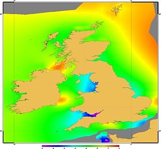
Vertical Offshore Reference Frames (VORF) is a set of high resolution surfaces which together define the vertical datum for hydrographic surveying and charting in the United Kingdom and Ireland. The following surfaces are included:
References
- ↑ Rickards, L.; Matthwes, A.; Gordon, K.; Tamisea, M.; Jevrejeva, S.; Woodworth, P.; Bradshaw, E. (2015). "Rickards et al., 2013: Celebrating 80 years of the Permanent Service for Mean Sea Level (PSMSL)". Proceedings of the International Association of Hydrological Sciences. 365: 1–5. doi: 10.5194/piahs-365-1-2015 .
- ↑ "PSMSL Ocean Bottom Pressure processing procedures" . Retrieved 20 April 2017.