A buoy is a floating device that can have many purposes. It can be anchored (stationary) or allowed to drift with ocean currents.

A weather station is a facility, either on land or sea, with instruments and equipment for measuring atmospheric conditions to provide information for weather forecasts and to study the weather and climate. The measurements taken include temperature, atmospheric pressure, humidity, wind speed, wind direction, and precipitation amounts. Wind measurements are taken with as few other obstructions as possible, while temperature and humidity measurements are kept free from direct solar radiation, or insolation. Manual observations are taken at least once daily, while automated measurements are taken at least once an hour. Weather conditions out at sea are taken by ships and buoys, which measure slightly different meteorological quantities such as sea surface temperature (SST), wave height, and wave period. Drifting weather buoys outnumber their moored versions by a significant amount.
The Tropical Ocean Global Atmosphere program (TOGA) was a ten-year study (1985–1994) of the World Climate Research Programme (WCRP) aimed specifically at the prediction of climate phenomena on time scales of months to years.

Sea surface temperature (SST), or ocean surface temperature, is the ocean temperature close to the surface. The exact meaning of surface varies in the literature and in practice. It is usually between 1 millimetre (0.04 in) and 20 metres (70 ft) below the sea surface. Sea surface temperatures greatly modify air masses in the Earth's atmosphere within a short distance of the shore. Local areas of heavy snow can form in bands downwind of warm water bodies within an otherwise cold air mass. Warm sea surface temperatures can develop and strengthen cyclones over the Ocean. Experts call this process tropical cyclogenesis. Tropical cyclones can also cause a cool wake. This is due to turbulent mixing of the upper 30 metres (100 ft) of the ocean. Sea surface temperature changes during the day. This is like the air above it, but to a lesser degree. There is less variation in sea surface temperature on breezy days than on calm days. Ocean currents, such as the Atlantic Multidecadal Oscillation, can affect sea surface temperatures over several decades. Thermohaline circulation has a major impact on average sea surface temperature throughout most of the world's oceans.

A weather ship, or ocean station vessel, was a ship stationed in the ocean for surface and upper air meteorological observations for use in weather forecasting. They were primarily located in the north Atlantic and north Pacific oceans, reporting via radio. The vessels aided in search and rescue operations, supported transatlantic flights, acted as research platforms for oceanographers, monitored marine pollution, and aided weather forecasting by weather forecasters and in computerized atmospheric models. Research vessels remain heavily used in oceanography, including physical oceanography and the integration of meteorological and climatological data in Earth system science.

Deep-ocean Assessment and Reporting of Tsunamis (DART) is a component of an enhanced tsunami warning system.
This is a list of meteorology topics. The terms relate to meteorology, the interdisciplinary scientific study of the atmosphere that focuses on weather processes and forecasting.

The National Data Buoy Center (NDBC) is a part of the National Oceanic and Atmospheric Administration's (NOAA) National Weather Service (NWS). NDBC designs, develops, operates, and maintains a network of data collecting buoys and coastal stations. The NDBC is located in southern Mississippi as a tenant at the John C. Stennis Space Center, a National Aeronautics and Space Administration (NASA) facility.

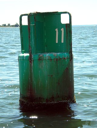
Weather buoys are instruments which collect weather and ocean data within the world's oceans, as well as aid during emergency response to chemical spills, legal proceedings, and engineering design. Moored buoys have been in use since 1951, while drifting buoys have been used since 1979. Moored buoys are connected with the ocean bottom using either chains, nylon, or buoyant polypropylene. With the decline of the weather ship, they have taken a more primary role in measuring conditions over the open seas since the 1970s. During the 1980s and 1990s, a network of buoys in the central and eastern tropical Pacific Ocean helped study the El Niño-Southern Oscillation. Moored weather buoys range from 1.5–12 metres (5–40 ft) in diameter, while drifting buoys are smaller, with diameters of 30–40 centimetres (12–16 in). Drifting buoys are the dominant form of weather buoy in sheer number, with 1250 located worldwide. Wind data from buoys has smaller error than that from ships. There are differences in the values of sea surface temperature measurements between the two platforms as well, relating to the depth of the measurement and whether or not the water is heated by the ship which measures the quantity.

The climate of California varies widely from hot desert to alpine tundra, depending on latitude, elevation, and proximity to the Pacific Coast. California's coastal regions, the Sierra Nevada foothills, and much of the Central Valley have a Mediterranean climate, with warmer, drier weather in summer and cooler, wetter weather in winter. The influence of the ocean generally moderates temperature extremes, creating warmer winters and substantially cooler summers in coastal areas.
The Coastal-Marine Automated Network (C-MAN) is a meteorological observation network along the coastal United States. Consisting of about sixty stations installed on lighthouses, at capes and beaches, on near shore islands, and on offshore platforms, the stations record atmospheric pressure, wind direction, speed and gust, and air temperature; however, some C-MAN stations are designed to also measure sea surface temperature, water level, waves, relative humidity, precipitation, and visibility.

The climate of Pennsylvania is diverse due to the multitude of geographic features found within the state. Straddling two major climate zones, the southeastern corner of Pennsylvania has the warmest climate. A portion of Greater Philadelphia lies at the southernmost tip of the humid continental climate zone, with the city proper being in the humid subtropical climate zone. Still, Philadelphia features colder, snowier winters than most locations with a humid subtropical climate. Moving west toward the mountainous interior of the state, the climate becomes markedly colder, the number of cloudy days increases, and winter snowfall amounts are greater.
The following are considered ocean essential climate variables (ECVs) by the Ocean Observations Panel for Climate (OOPC) that are currently feasible with current observational systems.

The 1974–75 South-West Indian Ocean cyclone season was an average cyclone season. The season officially ran from November 1, 1974, to April 30, 1975.

Weather reconnaissance is the acquisition of weather data used for research and planning. Typically the term reconnaissance refers to observing weather from the air, as opposed to the ground.

CORA is a global oceanographic temperature and salinity dataset produced and maintained by the French institute IFREMER. Most of those data are real-time data coming from different types of platforms such as research vessels, profilers, underwater gliders, drifting buoys, moored buoys, sea mammals and ships of opportunity.
The Tropical Atmosphere Ocean (TAO) project is a major international effort that instrumented the entire tropical Pacific Ocean with approximately 70 deep ocean moorings. The development of the TAO array in 1985 was motivated by the 1982-1983 El Niño event and ultimately designed for the study of year-to-year climate variations related to El Niño and the Southern Oscillation (ENSO). Led by the TAO Project Office of the Pacific Marine Environmental Laboratory (PMEL), the full array of 70 moorings was completed in 1994.
The Research Moored Array for African-Asian-Australian Monsoon Analysis and Prediction (RAMA) is a system of moored observation buoys in the Indian Ocean that collects meteorological and oceanographic data. The data collected by RAMA will greatly enhance the ability of scientists to understand climatic events and predict monsoon events. Climatic and oceanic events in the Indian Ocean affect weather and climate throughout the rest of the world, so RAMA will support weather forecasting and climate research worldwide. Although widely supported internationally, the system has only been partially implemented due to pirate activity off the coast of Somalia.

Null Island is the location at zero degrees latitude and zero degrees longitude, i.e., where the prime meridian and the equator intersect. The name is often used in mapping software as a placeholder to help find and correct database entries that have erroneously been assigned the coordinates 0,0. Although "Null Island" started as a joke within the geospatial community, it has become a useful means of addressing a recurring issue in geographic information science.

The Global Drifter Program (GDP) was conceived by Prof. Peter Niiler, with the objective of collecting measurements of surface ocean currents, sea surface temperature and sea-level atmospheric pressure using drifters. It is the principal component of the Global Surface Drifting Buoy Array, a branch of NOAA's Global Ocean Observations and a scientific project of the Data Buoy Cooperation Panel (DBCP). The project originated in February 1979 as part of the TOGA/Equatorial Pacific Ocean Circulation Experiment (EPOCS) and the first large-scale deployment of drifters was in 1988 with the goal of mapping the tropical Pacific Ocean's surface circulation. The current goal of the project is to use 1250 satellite-tracked surface drifting buoys to make accurate and globally dense in-situ observations of mixed layer currents, sea surface temperature, atmospheric pressure, winds and salinity, and to create a system to process the data. Horizontal transports in the oceanic mixed layer measured by the GDP are relevant to biological and chemical processes as well as physical ones.
