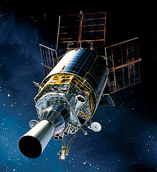
The Geo-IK-2 is a Russian series of new generation military [1] geodesy satellites replacing the Soviet Union's Geo-IK [2] and Sfera [3] constellations. They are intended to be used to create high precision three-dimensional maps of the Earth's surface, and to monitor plate tectonics. The satellites are produced by ISS Reshetnev, and have a mass of around 1,400 kilograms (3,100 lb). [4] They operate in a circular orbit at an altitude of around 1,000 kilometres (620 mi) above the Earth's surface.
Not to be confused with the Napryazhenie / 14F150 / Nivelir military geodesy satellites. [5] [6]
| Designation | Launch date (GMT) | Carrier rocket | Orbit | Remarks |
|---|---|---|---|---|
| Geo-IK-2 #11 / Musson 2 #1 (Kosmos 2470) [4] | 1 February 2011 14:00 | Rokot/Briz-KM | Failed to enter usable orbit | Failure [7] |
| Geo-IK-2 #12 / Musson 2 #2 (Kosmos 2517) [4] | 4 June 2016 14:00 | Rokot/Briz-KM | 936 km × 961 km, 99.28° | Operational |
| Geo-IK-2 #13 / Musson 2 #3 (Kosmos 2540) [8] | 30 August 2019 14:00 | Rokot/Briz-KM | Originally planned on a Soyuz-2-1v, switched to a Rokot in June 2017. |

In satellite laser ranging (SLR) a global network of observation stations measures the round trip time of flight of ultrashort pulses of light to satellites equipped with retroreflectors. This provides instantaneous range measurements of millimeter level precision which can be accumulated to provide accurate measurement of orbits and a host of important scientific data. The laser pulse can also be reflected by the surface of a satellite without a retroreflector, which is used for tracking space debris.
Satellite geodesy is geodesy by means of artificial satellites—the measurement of the form and dimensions of Earth, the location of objects on its surface and the figure of the Earth's gravity field by means of artificial satellite techniques. It belongs to the broader field of space geodesy. Traditional astronomical geodesy is not commonly considered a part of satellite geodesy, although there is considerable overlap between the techniques.

Gonets is a Russian civilian low Earth orbit communications satellite system. It consists of a number of satellites, derived from Strela military communications satellites. The first two satellites, which were used to test and validate the system, were launched by a Tsyklon-3 launch vehicle from the Plesetsk Cosmodrome on 13 July 1992, and were designated Gonets-D. The first operational satellites, designated Gonets-D1, were launched on 19 February 1996. After launch, the first three satellites were given military Kosmos designations, a practice which was not continued with the other satellites.
Kosmos 2470, also known as Geo-IK-2 No.11, was a Russian geodesy satellite launched in 2011. The first Geo-IK-2 satellite, it was intended to be used to create a three-dimensional map of the Earth's surface, and to monitor plate tectonics. The satellite was produced by ISS Reshetnev, and has a mass of around 1,400 kilograms (3,100 lb). It was intended to operate in a circular orbit at an altitude of around 1,000 kilometres (620 mi) above the Earth's surface; however, it was placed into a lower than planned orbit after its launch failed.

This article compares different orbital launcher families. The article is organized into two tables: the first contains a list of currently active and under-development launcher families, while the second contains a list of retired launcher families.

This article documents notable spaceflight events during the year 2019.

Notable spaceflight activities in 2017 included the maiden orbital flight of India's Geosynchronous Satellite Launch Vehicle Mark III on 5 June and the first suborbital test of Rocket Lab's Electron rocket, inaugurating the Mahia spaceport in New Zealand. The rocket is named for its innovative Rutherford engine which feeds propellants via battery-powered electric motors instead of the usual gas generator and turbopumps.

This article documents notable spaceflight events during the year 2018. For the first time since 1990, more than 100 orbital launches were performed globally.
This page includes a list of satellite buses, of which multiple similar artificial satellites have been, or are being, built to the same model of structural frame, propulsion, spacecraft power and intra-spacecraft communication. Only commercially available buses are included, thus excluding series-produced proprietary satellites operated only by their makers.
An early warning satellite is a satellite designed to rapidly identify ballistic missile launches and thus enable defensive military action. This type of satellite was developed during the Cold War and later became a component of missile defense systems.

A small-lift launch vehicle is a rocket orbital launch vehicle that is capable of lifting 2,000 kilograms (4,400 lb) or less or under 5,000 kilograms (11,000 lb) of payload into low Earth orbit (LEO). The next larger category consists of medium-lift launch vehicles.
Olymp-K is a Russian geostationary satellite built for the Russian Ministry of Defence and Federal Security Service (FSB). The satellite is also referred to as "Luch". It is believed to be a signals intelligence satellite.

Sfera was a series of Soviet geodetic satellites.
NanoACE is a technology demonstration CubeSat by Tyvak Nano-Satellite Systems to validate their communications, navigation, guidance, and software technology. NanoACE was launched onboard a Soyuz-2.1a Fregat-M, on July 14, 2017, along with Russian Earth imaging satellite Kanopus-V-IK and 71 other CubeSats.
| | This spacecraft or satellite related article is a stub. You can help Wikipedia by expanding it. |