Himawari 9

Last updated

Himawari 9
Himawari89 2.jpg
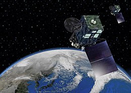
Rendering of Himawari 8 and 9
Mission type Weather satellite
Operator JMA
COSPAR ID 2016-064A [1]
SATCAT no. 41836 OOjs UI icon edit-ltr-progressive.svg
Mission duration8 years (planned)
Spacecraft properties
Bus DS2000
Manufacturer Mitsubishi Electric
Launch mass3500 kg
Dry mass1300 kg
Power2.6 kilowatts from solar array
Start of mission
Launch date06:20:00,2 November 2016(UTC) (2016-11-02T06:20:00Z)
Rocket H-IIA 202
Launch site Tanegashima LA-Y1
Contractor Mitsubishi Heavy Industries
Entered service05:00:00,13 December 2022(UTC) (2022-12-13T05:00:00Z)
Orbital parameters
Reference system Geocentric
Regime Geostationary
Longitude140.7° East
Epoch Planned
 

Himawari 9 is a Japanese weather satellite, the 9th of the Himawari geostationary weather satellite operated by the Japan Meteorological Agency. The spacecraft was constructed by Mitsubishi Electric, and is the second of two similar satellites to be based on the DS-2000 bus. [2]

Contents

Launch

Himawari 9 was launched on 2 November 2016, 06:20:00 UTC, atop a H-IIA rocket flying from the Yoshinobu Launch Complex Pad 1 at the Tanegashima Space Center, and by 11 November 2016 it reached to the geostationary point at 140.7 degrees East. [3] After initial function tests, it was put on standby until 05:00 UTC by 13 December 2022, when it succeeded Himawari 8. [4] [5]

The launch was scheduled initially on 1 November 2016, but postponed for one day due to the bad weather forecast.

At launch, the mass of the satellite is about 3,500 kilograms (7,700 lb). It has a design life of 15 years with 8 years of operational life. Power is supplied by a single gallium arsenide solar panel, which provides up to 2.6 kilowatts of power. The main instrument aboard Himawari 9 is a 16 channel multispectral imager to capture visible light and infrared images of the Asian-Pacific region. [6]

As part of an outreach project organized by the Young Astronauts Club Japan the launch also carried manga artwork drawn by Chūya Koyama, author of the Space Brothers manga. [7]

Related Research Articles

<span class="mw-page-title-main">Geostationary orbit</span> Circular orbit above Earths Equator and following the direction of Earths rotation

A geostationary orbit, also referred to as a geosynchronous equatorial orbit (GEO), is a circular geosynchronous orbit 35,786 km (22,236 mi) in altitude above Earth's equator, 42,164 km (26,199 mi) in radius from Earth's center, and following the direction of Earth's rotation.

<span class="mw-page-title-main">Geostationary Operational Environmental Satellite</span> US weather satellite series

The Geostationary Operational Environmental Satellite (GOES), operated by the United States' National Oceanic and Atmospheric Administration (NOAA)'s National Environmental Satellite, Data, and Information Service division, supports weather forecasting, severe storm tracking, and meteorology research. Spacecraft and ground-based elements of the system work together to provide a continuous stream of environmental data. The National Weather Service (NWS) and the Meteorological Service of Canada use the GOES system for their North American weather monitoring and forecasting operations, and scientific researchers use the data to better understand land, atmosphere, ocean, and climate dynamics.

<span class="mw-page-title-main">Weather satellite</span> Type of satellite designed to record the state of the Earths atmosphere

A weather satellite or meteorological satellite is a type of Earth observation satellite that is primarily used to monitor the weather and climate of the Earth. Satellites can be polar orbiting, or geostationary.

<span class="mw-page-title-main">Japan Meteorological Agency</span> National meteorological service of Japan

The Japan Meteorological Agency, abbreviated JMA, is an agency of the Ministry of Land, Infrastructure, Transport and Tourism. It is charged with gathering and providing results for the public in Japan that are obtained from data based on daily scientific observation and research into natural phenomena in the fields of meteorology, hydrology, seismology and volcanology, among other related scientific fields. Its headquarters is located in Minato, Tokyo.

<span class="mw-page-title-main">EUMETSAT</span> European intergovernmental organisation

The European Organisation for the Exploitation of Meteorological Satellites (EUMETSAT) is an intergovernmental organisation created through an international convention agreed by a current total of 30 European Member States.

<span class="mw-page-title-main">Meteosat</span> Series of european weather satellites

The Meteosat series of satellites are geostationary meteorological satellites operated by EUMETSAT under the Meteosat Transition Programme (MTP) and the Meteosat Second Generation (MSG) program.

<span class="mw-page-title-main">H-IIA</span> Expendable medium-lift launch vehicle

H-IIA (H-2A) is an active expendable launch system operated by Mitsubishi Heavy Industries (MHI) for the Japan Aerospace Exploration Agency. These liquid fuel rockets have been used to launch satellites into geostationary orbit; lunar orbiting spacecraft; Akatsuki, which studied the planet Venus; and the Emirates Mars Mission, which was launched to Mars in July 2020. Launches occur at the Tanegashima Space Center. The H-IIA first flew in 2001. As of December 2021, H-IIA rockets were launched 45 times, including 39 consecutive missions without a failure, dating back to 29 November 2003.

<span class="mw-page-title-main">Multi-Functional Transport Satellite</span> Series of weather and aviation control satellites

Multifunctional Transport Satellites (MTSAT) were a series of weather and aviation control satellites. They are replaced by Himawari 8 on 7 July 2015. They were geostationary satellites owned and operated by the Japanese Ministry of Land, Infrastructure, Transport and Tourism (MLIT) and the Japan Meteorological Agency (JMA), and provide coverage for the hemisphere centred on 140.0° East; this includes Japan and Australia who are the principal users of the satellite imagery that MTSAT provides. They replace the GMS-5 satellite, also known as Himawari 5. They can provide imagery in five wavelength bands — visible and four infrared, including the water vapour channel. The visible light camera has a resolution of 1 km; the infrared cameras have 4 km. The spacecraft have a planned lifespan of five years. MTSAT-1 and 1R were built by Space Systems/Loral. MTSAT-2 was built by Mitsubishi.

The N-II or N-2 was a derivative of the American Delta rocket, produced under licence in Japan. It replaced the N-I-rocket in Japanese use. It used a Thor-ELT first stage, a Delta-F second stage, nine Castor SRMs, and on most flights either a Star-37E or Burner-2 upper stage, identical to the US Delta 0100 series configurations. Eight were launched between 1981 and 1987, before it was replaced by the H-I, which featured Japanese-produced upper stages. All eight launches were successful.

<span class="mw-page-title-main">Himawari (satellites)</span> Geostationary Meteorological Satellite

The Himawari geostationary satellites, operated by the Japan Meteorological Agency (JMA), support weather forecasting, tropical cyclone tracking, and meteorology research. Most meteorological agencies in East Asia, Southeast Asia, Australia and New Zealand use the satellites for their own weather monitoring and forecasting operations.

INSAT-2E is an Indian geostationary communications and weather satellite which is operated by the Indian National Satellite System. It is positioned in geostationary orbit at a longitude of 83° East, from where it is used to provide communications services to Asia and Australia. It also carries two meteorological instruments; the Very High Resolution Radiometer, and a CCD camera capable of returning images with a resolution of one kilometre.

<span class="mw-page-title-main">TDRS-10</span> American communications satellite

TDRS-10, known before launch as TDRS-J, is an American communications satellite which is operated by NASA as part of the Tracking and Data Relay Satellite System. It was constructed by the Boeing Satellite Development Center, formerly Hughes Space and Communications, and is based on the BSS-601 satellite bus. It was the third and final Advanced TDRS, or second-generation Tracking and Data Relay Satellite, to be launched.

Negai☆″ is a Japanese satellite which launched in May 2010. It is a student-built spacecraft, which will be operated by Soka University, and is intended to be used for technology demonstration. The satellite is a single unit CubeSat, and will be used to test a field programmable gate array in orbit. As part of an outreach programme, it will carry the names of selected children, along with wishes they have made. The satellite will return images of the Earth, which will be given to the participating children.

<span class="mw-page-title-main">Elektro–L</span>

Elektro–L is a series of meteorological satellites developed for the Russian Federal Space Agency by NPO Lavochkin. The first satellite, Elektro-L No.1, was launched on 2 January 2011. It is the first Russian weather satellite that successfully operates in geostationary orbit, and is currently the second operational Russian weather satellite. The satellites have a mass of about 1620 kg and are designed to operate for 10 years each. They are capable of producing images of the Earth's whole hemisphere in both visible and infrared frequencies, providing data for climate change and ocean monitoring in addition to their primary weather forecasting role.

<span class="mw-page-title-main">Elektro-L No.1</span> Weather satellite

Elektro-L No.1, also known as Geostationary Operational Meteorological Satellite No.2 or GOMS No.2, is a Russian geostationary weather satellite which was launched in 2011. The first Elektro-L spacecraft to fly, it became the first Russian geostationary weather satellite to be launched since Elektro No.1 in 1994.

<span class="mw-page-title-main">Japanese space program</span> Space program of Japan

The Japanese space program originated in the mid-1950s as a research group led by Hideo Itokawa at the University of Tokyo. The size of the rockets produced gradually increased from under 30 cm (12 in) at the start of the project, to over 15 m (49 ft) by the mid-1960s. The aim of the original research project was to launch a man-made satellite.

<span class="mw-page-title-main">GOES-16</span> NOAA weather satellite

GOES-16, formerly known as GOES-R before reaching geostationary orbit, is the first of the GOES-R series of Geostationary Operational Environmental Satellites (GOES) operated by NASA and the National Oceanic and Atmospheric Administration (NOAA). GOES-16 serves as the operational geostationary weather satellite in the GOES East position at 75.2°W, providing a view centered on the Americas. GOES-16 provides high spatial and temporal resolution imagery of the Earth through 16 spectral bands at visible and infrared wavelengths using its Advanced Baseline Imager (ABI). GOES-16's Geostationary Lightning Mapper (GLM) is the first operational lightning mapper flown in geostationary orbit. The spacecraft also includes four other scientific instruments for monitoring space weather and the Sun.

<span class="mw-page-title-main">Himawari 8</span> Japanese weather satellite

Himawari 8 (ひまわり8号) is a Japanese weather satellite, the 8th of the Himawari geostationary weather satellites operated by the Japan Meteorological Agency. The spacecraft was constructed by Mitsubishi Electric with assistance from Boeing, and is the first of two similar satellites to be based on the DS2000 satellite bus. Himawari 8 entered operational service on 7 July 2015 and is the successor to MTSAT-2 which was launched in 2006.

Chūya Koyama is a Japanese writer, best known for his Space Brothers series, published regularly since 2007.

References

  1. "Himawari 9". NASA Space Science Data Coordinated Archive.
  2. Graham, William (6 October 2014). "Japan lofts Himawari 8 weather satellite via H-IIA rocket". NASASpaceflight.com. Retrieved 7 October 2014.
  3. 「ひまわり9号」の静止化の完了について (in Japanese). Japan Meteorological Agency. 11 November 2016. Retrieved 11 November 2016.
  4. "JMA/MSC: Himawari-8/9". Japan Meteorological Agency. Archived from the original on 23 September 2015. Retrieved 7 October 2014.
  5. "Meteorological Satellite Center (MSC) | Switchover of the Operational Satellite". www.data.jma.go.jp. Japan Meteorological Agency. Retrieved 12 November 2022.
  6. "New geostationary meteorological satellites — Himawari-8/9 —" (PDF). Japan Meteorological Agency. Retrieved 7 October 2014.
  7. "Japanese rocket decked out in manga art launches satellite into space". Hindustan Times. 2 November 2016. Retrieved 25 June 2020.