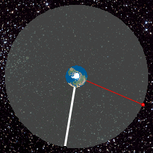
A geostationary orbit, also referred to as a geosynchronous equatorial orbit (GEO), is a circular geosynchronous orbit 35,786 km (22,236 mi) in altitude above Earth's equator, 42,164 km (26,199 mi) in radius from Earth's center, and following the direction of Earth's rotation.

The Geostationary Operational Environmental Satellite (GOES), operated by the United States' National Oceanic and Atmospheric Administration (NOAA)'s National Environmental Satellite, Data, and Information Service division, supports weather forecasting, severe storm tracking, and meteorology research. Spacecraft and ground-based elements of the system work together to provide a continuous stream of environmental data. The National Weather Service (NWS) and the Meteorological Service of Canada use the GOES system for their North American weather monitoring and forecasting operations, and scientific researchers use the data to better understand land, atmosphere, ocean, and climate dynamics.

A weather satellite or meteorological satellite is a type of Earth observation satellite that is primarily used to monitor the weather and climate of the Earth. Satellites can be polar orbiting, or geostationary.

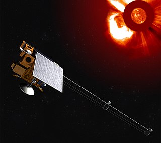
Deep Space Climate Observatory is a National Oceanic and Atmospheric Administration (NOAA) space weather, space climate, and Earth observation satellite. It was launched by SpaceX on a Falcon 9 v1.1 launch vehicle on 11 February 2015, from Cape Canaveral. This is NOAA's first operational deep space satellite and became its primary system of warning Earth in the event of solar magnetic storms.
The Lockheed Martin Solar and Astrophysics Laboratory (LMSAL) is part of the Lockheed Martin Advanced Technology Center (ATC) that is known primarily for its scientific work in the field of solar physics, astronomy and space weather. The LMSAL team is part of Lockheed Martin Space Systems and has close affiliations with NASA and the solar physics group at Stanford University.

The National Environmental Satellite, Data, and Information Service (NESDIS) was created by the National Oceanic and Atmospheric Administration (NOAA) to operate and manage the United States environmental satellite programs, and manage the data gathered by the National Weather Service and other government agencies and departments.

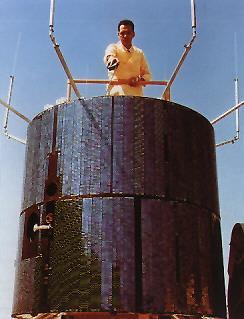
GOES-1, designated GOES-A and SMS-C prior to entering service, was a weather satellite, developed by the NASA, operated by the United States National Oceanic and Atmospheric Administration (NOAA). It was the first Geostationary Operational Environmental Satellite (GOES) to be launched.

The Delta IV Heavy was an expendable heavy-lift launch vehicle, the largest type of the Delta IV family. It was the world's third highest-capacity launch vehicle in operation at the time of its retirement in 2024, behind NASA's Space Launch System and SpaceX's Falcon Heavy and closely followed by CASC's Long March 5. It was manufactured by United Launch Alliance (ULA) and was first launched in 2004. ULA retired the Delta IV Heavy in 2024. Future ULA launches will use the new Vulcan Centaur rocket. Delta IV's final flight was on 9 April 2024.
GOES-14, known as GOES-O prior to reaching its operational orbit, is an American weather satellite, which is part of the US National Oceanic and Atmospheric Administration (NOAA)'s Geostationary Operational Environmental Satellite (GOES) system. The spacecraft was built by Boeing and is based on the BSS-601 bus. It is the second of three GOES satellites to use the BSS-601 bus, after GOES-13, which was launched in May 2006.

GPS satellite blocks are the various production generations of the Global Positioning System (GPS) used for satellite navigation. The first satellite in the system, Navstar 1, was launched on 22 February 1978. The GPS satellite constellation is operated by the 2nd Space Operations Squadron (2SOPS) of Space Delta 8, United States Space Force.

EWS-G1 is a weather satellite of the U.S. Space Force, formerly GOES-13 and part of the National Oceanic and Atmospheric Administration's Geostationary Operational Environmental Satellite system. On 14 April 2010, GOES-13 became the operational weather satellite for GOES-East. It was replaced by GOES-16 on 18 December 2017 and on 8 January 2018 its instruments were shut off and it began its three-week drift to an on-orbit storage location at 60.0° West longitude, arriving on 31 January 2018. It remained there as a backup satellite in case one of the operational GOES satellites had a problem until early July 2019, when it started to drift westward and was being transferred to the U.S. Air Force, and then the U.S. Space Force.

EWS-G2 is a weather satellite of the U.S. Space Force, formerly GOES-15. The spacecraft was constructed by Boeing, and is the last of three GOES satellites to be based on the BSS-601 bus. It was launched in 2010, while the other BSS-601 GOES satellites—GOES-13 and GOES-14—were launched in May 2006 and June 2009 respectively. It was the sixteenth GOES satellite to be launched.
ATS-1, also designated ATS-B or Advanced Tech. Sat. 1, was an experimental geostationary satellite, launched in 1966. Though intended as a communications satellite rather than as a weather satellite, it carried the Spin Scan Cloud Camera developed by Verner E. Suomi and Robert Parent at the University of Wisconsin. After entering an orbit at 23,000 mi (37,000 km) above Earth, initially in orbit over Ecuador, it transmitted weather images from the Western Hemisphere, as well as other data, to ground stations, including well as video feeds for television broadcasting.
GOES-16, formerly known as GOES-R before reaching geostationary orbit, is the first of the GOES-R series of Geostationary Operational Environmental Satellites (GOES) operated by NASA and the National Oceanic and Atmospheric Administration (NOAA). GOES-16 serves as the operational geostationary weather satellite in the GOES East position at 75.2°W, providing a view centered on the Americas. GOES-16 provides high spatial and temporal resolution imagery of the Earth through 16 spectral bands at visible and infrared wavelengths using its Advanced Baseline Imager (ABI). GOES-16's Geostationary Lightning Mapper (GLM) is the first operational lightning mapper flown in geostationary orbit. The spacecraft also includes four other scientific instruments for monitoring space weather and the Sun.

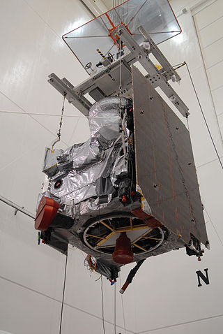
GOES-17 is an environmental satellite operated by the National Oceanic and Atmospheric Administration (NOAA). The satellite is second in the four-satellite GOES-R series. GOES-17 supports the Geostationary Operational Environmental Satellite (GOES) system, providing multi-spectral imaging for weather forecasts and meteorological and environmental research. The satellite was built by Lockheed Martin, based on the A2100A platform, and expected to have a useful life of 15 years. GOES-17 is intended to deliver high-resolution visible and infrared imagery and lightning observations of more than half the globe.
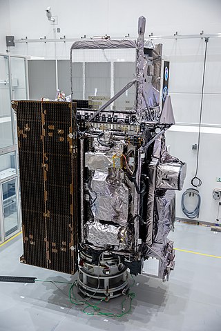
GOES-18 is the third of the "GOES-R Series", the current generation of weather satellites operated by the National Oceanic and Atmospheric Administration (NOAA). The current and next satellites of the Series will extend the availability of the Geostationary Operational Environmental Satellite (GOES) satellite system until 2037. The satellite is built by Lockheed Martin in Littleton, Colorado. It is based on the A2100A satellite bus and will have an expected useful life of 15 years.

NOAA-21, designated JPSS-2 prior to launch, is the second of the United States National Oceanic and Atmospheric Administration (NOAA)'s latest generation of U.S. polar-orbiting, non-geosynchronous, environmental satellites called the Joint Polar Satellite System. NOAA-21 was launched on 10 November 2022 and join NOAA-20 and Suomi NPP in the same orbit. Circling the Earth from pole-to-pole, it will cross the equator about 14 times daily, providing full global coverage twice a day. It was launched with LOFTID.
The Vigil mission, formerly known as Lagrange, is a Space weather weather mission developed by European Space Agency. The mission will provide the ESA Space Weather Office with instruments able to monitor the Sun, its solar corona and interplanetary medium between the Sun and Earth, to provide early warnings of increased solar activity, to identify and mitigate potential threats to society and ground, airborne and space based infrastructure as well as to allow 4 to 5 days space weather forecasts. To this purpose the Vigil mission will place for the first time a spacecraft at Sun-Earth Lagrange point 5 (L5) from where it would get a 'side' view of the Sun, observing regions of solar activity on the solar surface before they turn and face Earth.
Space Weather Follow On-Lagrange 1 (SWFO-L1) is a future spacecraft mission planned to monitor signs of solar storms, which may pose harm to Earth's telecommunication network. The spacecraft will be operated by the National Oceanic and Atmospheric Administration (NOAA), with launch scheduled for 31 March 2025. It is planned to be placed at the Sun–Earth L1 Lagrange point, a location between the Earth and the Sun. This will allow SWFO-L1 to continuously watch the solar wind and energetic particles heading for Earth. SWFO-L1 is an ESPA Class Spacecraft, sized for launch on an Evolved Expendable Launch Vehicle Secondary Payload Adapter (ESPA) Grande ring in addition to the rocket's primary payload. The spacecraft's Solar Wind Instrument Suite (SWIS) which includes three instruments will monitor solar wind, and the Compact Coronagraph (CCOR) will monitor the Sun's surroundings to image coronal mass ejection (CME). A CME is a large outburst of plasma sent from the Sun towards interplanetary space.

The Geostationary Extended Observations (GeoXO) satellite system is the National Oceanic and Atmospheric Administration (NOAA)'s planned replacement for the existing Geostationary Operational Environmental Satellite (GOES) satellites. These new geostationary satellites will make weather, ocean, and climate observations. The project aims to begin observations in the early 2030s as the GOES-R satellites reach their operational lifetime. The first GeoXO satellite is scheduled to be launched in 2032, with two more following in 2035, and the mission will maintain and advance NOAA’s geostationary observations through 2055.

