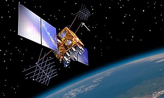
| Mission type | Navigation |
|---|---|
| COSPAR ID | 2010-001A |
| SATCAT no. | 36287 |
| Spacecraft properties | |
| Bus | DFH-3 |
| Manufacturer | CAST |
| Start of mission | |
| Launch date | 16 January 2010, 16:12:04 UTC |
| Rocket | Chang Zheng 3C |
| Launch site | Xichang LC-2 |
| Orbital parameters | |
| Reference system | Geocentric |
| Regime | Geosynchronous |
| Perigee altitude | 35,775 kilometres (22,230 mi) |
| Apogee altitude | 35,807 kilometres (22,249 mi) |
| Inclination | 1.58 degrees |
| Period | 23.93 hours |
| Epoch | 24 December 2013, 10:17:46 UTC [1] |
Compass-G1, also known as Beidou-2 G1, is a Chinese navigation satellite which will become part of the Compass navigation system. It was launched in January 2010, and became the third Compass satellite to be launched after Compass-M1 and Compass-G2.
Compass-G1 was launched at 16:12 GMT on 16 January 2010, [2] and was the first orbital launch to be conducted in 2010. [3] The launch used a Long March 3C carrier rocket, flying from the Xichang Satellite Launch Centre. It was the first flight of a Long March 3 series rocket since an upper stage engine problem in August 2009 which left the Palapa-D satellite in a lower than planned orbit. [4] The injection systems on the rocket's third stage engines had filters fitted to them in an attempt to prevent a recurrence of this failure. The Compass-G1 launch demonstrated this new system. [5]
Compass-G1 had originally been scheduled for launch in the first half of 2009, however it was subsequently delayed after issues developed with the Beidou-1D [6] [7] and Compass-G2 satellites. [8]
GLONASS is a Russian space-based satellite navigation system operating as part of a radionavigation-satellite service. It provides an alternative to Global Positioning System (GPS) and is the second navigational system in operation with global coverage and of comparable precision.
The BeiDou Navigation Satellite System is a Chinese satellite navigation system. It consists of two separate satellite constellations. The first BeiDou system, officially called the BeiDou Satellite Navigation Experimental System and also known as BeiDou-1, consisted of three satellites which, beginning in 2000, offered limited coverage and navigation services, mainly for users in China and neighboring regions. BeiDou-1 was decommissioned at the end of 2012. On 23 June 2020, the final BeiDou satellite was successfully launched, the launch of the 55th satellite in the Beidou family. The third iteration of the Beidou Navigation Satellite System provides for global coverage for timing and navigation, offering an alternative to Russia's GLONASS, the European Galileo positioning system, and the US's GPS.

A satellite navigation or satnav system is a system that uses satellites to provide autonomous geo-spatial positioning. It allows small electronic receivers to determine their location to high precision using time signals transmitted along a line of sight by radio from satellites. The system can be used for providing position, navigation or for tracking the position of something fitted with a receiver. The signals also allow the electronic receiver to calculate the current local time to high precision, which allows time synchronisation. These uses are collectively known as Positioning, Navigation and Timing (PNT). Satnav systems operate independently of any telephonic or internet reception, though these technologies can enhance the usefulness of the positioning information generated.

The Long March 3A, also known as the Chang Zheng 3A, CZ-3A and LM-3A, is a Chinese orbital carrier rocket design. It is a 3-stage rocket, and is usually used to place communications satellites and Beidou navigation satellites into geosynchronous transfer orbits.

The Indian Regional Navigation Satellite System (IRNSS), with an operational name of NavIC, is an autonomous regional satellite navigation system that provides accurate real-time positioning and timing services. It covers India and a region extending 1,500 km (930 mi) around it, with plans for further extension. An extended service area lies between the primary service area and a rectangle area enclosed by the 30th parallel south to the 50th parallel north and the 30th meridian east to the 130th meridian east, 1,500–6,000 km (930–3,730 mi) beyond borders. The system currently consists of a constellation of seven satellites, with two additional satellites on ground as stand-by.
The Long March 3C, also known as the Changzheng 3C, CZ-3C and LM-3C, is a Chinese orbital launch vehicle. It is launched from Launch Complex 2 and 3 at the Xichang Satellite Launch Center (XSLC). A three-stage rocket with two strapon liquid rocket boosters, it is a member of the Long March 3 rocket family, and was derived from the Long March 3B. It was designed to fill a gap in payload capacities between the Long March 3A and 3B.

GLONASS-K is the latest satellite design intended as a part of the Russian GLONASS radio-based satellite navigation system. Developed by ISS Reshetnev and first launched on 26 February 2011, it is a substantial improvement of the previous GLONASS-M second-generation satellites, having a longer lifespan and better accuracy.
USA-206, also GPS SVN-50, PRN-05 and NAVSTAR 64 and known before launch as GPS IIR-21, GPS IIRM-8 or GPS IIR-21(M), is an American navigation satellite which forms part of the Navstar Global Positioning System. It was the twenty-first and last Block IIR GPS satellite to be launched, and the eighth to use the modernised IIRM configuration.
The year 2012 saw a number of significant events in spaceflight. In May and October, the first Commercial Orbital Transportation Services resupply missions took place, during which the SpaceX Dragon became the first private spacecraft to dock with the International Space Station (ISS). In June, China launched the crewed Shenzhou 9 orbital mission, and North Korea achieved its first successful orbital launch in December. 2012 also saw China's first successful asteroid exploration mission, and the landing of NASA's Curiosity rover on Mars. The Vega and Unha-3 rockets made their maiden flights in 2012, while the Proton-K made its last.

USA-213, also known as GPS SVN-62, GPS IIF SV-1 and NAVSTAR 65, is the first satellite in the Block IIF series of Global Positioning System navigation satellites. It will be used to relay signals for the United States Air Force Navstar Global Positioning System (GPS). The satellite was launched at 03:00:00 UTC on 28 May 2010. It will be placed into plane B of the GPS constellation, and will transmit the PRN-25 signal. PRN-25 was previously broadcast by USA-79, which was retired in late 2009 after almost eighteen years of service.
GPS Block IIF, or GPS IIF is an interim class of GPS (satellite), which are used to keep the Navstar Global Positioning System operational until the GPS Block IIIA satellites become operational. They were built by Boeing, to be operated by the United States Air Force being launched by United Launch Alliance (ULA), using Evolved Expendable Launch Vehicles (EELV). They are the final component of the Block II GPS constellation to be launched. On 5 February 2016, the final satellite in the GPS Block IIF was successfully launched, completing the block.
Compass-IGSO1, also known as Beidou-2 IGSO1 is a Chinese navigation satellite which will become part of the Compass navigation system. It was launched in July 2010, and became the fifth Compass satellite to be launched after Compass-M1, G2, G1, and G3.

A space tug is a type of spacecraft used to transfer spaceborne cargo from one orbit to another orbit with different energy characteristics. An example would be moving a spacecraft from a low Earth orbit (LEO) to a higher-energy orbit like a geostationary transfer orbit, a lunar transfer, or an escape trajectory.
USA-203, also known as GPS IIR-20(M), GPS IIRM-7 and GPS SVN-49, is an American navigation satellite which was intended to become part of the Global Positioning System. It was the sixth of seven Block IIRM satellites to be launched, and the twentieth of twenty one Block IIR satellites overall. It was built by Lockheed Martin, using the AS-4000 satellite bus, and had a mass of 2,032 kilograms (4,480 lb).
Inside GNSS (IG) is an international controlled circulation trade magazine and website owned by Gibbons Media and Research LLC. It covers space-based positioning, navigation and timing (PNT) technology for engineers, designers, and policy-makers of global navigation satellite systems (GNSS). In the United States, GNSS is identified mainly with the government-operated Navstar Global Positioning System (GPS). InsideGNSS.com is the complimentary website of online news, events, digital newsletters, and webinars, and archived magazine articles.
Beidou-3 M1 is one of a pair of two Chinese navigation satellites launched in November 2017 as part of the BeiDou satellite navigation system. It was launched with BeiDou-3 M2.