Sangay

Last updated

Sangay
Sangay2.jpg
Highest point
Elevation 5,286 m (17,343 ft) [1] [2]
Prominence 1,588 m (5,210 ft) [3]
Listing Ultra
Coordinates 2°0′9″S78°20′27″W / 2.00250°S 78.34083°W / -2.00250; -78.34083 [4]
Naming
English translationThe Frightener [5]
Language of name Quechua
Pronunciation [saŋˈɡaj] [ needs Quechua IPA ]
Geography
Equador physical map.svg
Red triangle with thick white border.svg
Sangay
Location of Sangay in Ecuador
Location Ecuador
Parent range Andes
Geology
Mountain type Stratovolcano
Volcanic arc/belt North Volcanic Zone
Last eruption 1934 to 2024 (ongoing) [6]
Climbing
First ascent 4 August 1929 [5]
Easiest route Rock/Snow climb [7]

Sangay (also known as Macas, Sanagay, or Sangai) [8] is an active stratovolcano in central Ecuador. It exhibits mostly strombolian activity. Geologically, Sangay marks the southern boundary of the Northern Volcanic Zone, and its position straddling two major pieces of crust accounts for its high level of activity. Sangay's approximately 500,000-year-old history is one of instability; two previous versions of the mountain were destroyed in massive flank collapses, evidence of which still litters its surroundings today.

Contents

Due to its remoteness, Sangay hosts a significant biological community with fauna such as the mountain tapir, giant otter, Andean cock-of-the-rock and king vulture. Since 1979, its ecological community has been protected as part of the Sangay National Park. Although climbing the mountain is hampered by its remoteness, poor weather conditions, river flooding, and the danger of falling ejecta, the volcano is regularly climbed, a feat first achieved by Robert T. Moore in 1929.

History

Folklore sourced from native people in the region compared Sangay to a lighthouse surrounded by a sea, which represented the dense jungle. The density of the jungle caused people to lose their way, but seeing ash and steam emissions from the volcano would help orient travelers along their way. Scientists have interpreted folklore like this as evidence of frequent and long-lasting eruptive activity at Sangay. [9]

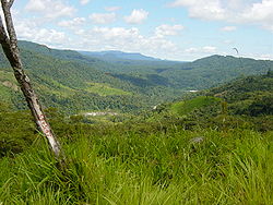
In January 2024, archaeologists announced the discovery of archaeological sites on the east side of the volcano known as the Upano Valley sites. It is estimated that this cluster of urban settlements were inhabited between about 500 BCE to sometime between 300 and 600 CE. Altogether the cities may have reached a population between 15,000 and 100,000 people. They were surrounded by agricultural fields that archaeologist Stéphen Rostain speculates may have been particularly productive because their proximity to Sangay. [10] [11]

Seventeen additional archaeological sites had been located prior to the 2024 announcement including potential monuments. An estimated 30,000 people lived in the region before Spanish occupation began in 1534. The Spanish prospected for gold on and around the volcano through the 16th and 17th Centuries and settled the area but expeditions undertaken in the 19th Century noted no inhabitants nearby. Modern development of the eastern side of the volcano began in the early 20th Century. [12]

The volcano and lands surrounding it were placed in a National Wildlife Reserve by the Ecuadorian government in 1975. This became Sangay National Park in 1979, which was expanded in 1992. The United Nations added it to their list of World Heritage Sites in 1983. From 1992 to 2005, poaching and human development led the UN to consider the site as being endangered but removed this status in 2005. [12]

The modern native inhabitants of the region primarily consist of Quechua people. [12] The name Sangay comes from the Quechuan languages and is translated as "the frightener." [5]

Geography

Sangay is on the eastern edge of the Andes Mountains in central Ecuador about 160 km (99 mi) south of Quito and 20 km (12 mi) east of Riobamba. It lies within Sangay National Park. Two nearby volcanoes, Tungurahua and El Altar, are also located within the national park. The three volcanoes reach exceed 5,000 m (16,000 ft) above sea level with El Altar being the tallest. [12]

The principal rivers draining Sangay are the Llushin, Palora, and the Upano, each of which have numerous smaller tributaries on the middle and upper slopes. Flash flooding from significant rainfall is frequent and erosion is a problem despite thick forests. Rivers drain east into the Amazon Basin. Topography is dominated by volcanic and glacial features. Hanging valleys from prior glaciation feature numerous waterfalls and lakes. [12]

Climate

Sangay reaches high enough to enjoy snow cover on its upper slopes despite its location near the Equator. It is disputed whether or not the volcano has a glacier though ice and snowfields are present. [13] [14] The snow line in this part of South America lies approximately 4,800 m (15,700 ft) above sea level. [12]

The mountain environment leads to significant changes in precipitation across short distances. Prevailing winds are out of the east, causing rainfall to be greatest to the east where moisture is sourced from the Amazon rainforest. [15] Observed rainfall averages from 4,827 mm (190.0 in) per year at Pastaza to the northeast of the volcano to 423 mm (16.7 in) at Riobamba just 20 km (12 mi) west of the summit in the rain shadow. [16] Orographic lift and the Intertropical Convergence Zone are major factors in precipitation values. [12]

Annual temperatures see little variability but diurnal changes in temperature can be wide in more arid portions of the mountain's slopes. Higher elevations never rise above 0 °C (32 °F). [12] Climate change threatens the snowpack and the high altitude grasslands. [14]

Geology

Regional setting

Sangay's summit peaks above cloud cover, seen from 9,000 m (29,500 ft). A plume of volcanic ash rises off of its summit. Sangay peak.jpg
Sangay's summit peaks above cloud cover, seen from 9,000 m (29,500 ft). A plume of volcanic ash rises off of its summit.

Lying at the eastern edge of the Andean cordillera, [17] Sangay was formed by volcanic processes associated with the subduction of the Nazca Plate under the South American Plate at the Peru–Chile Trench. [18] It is the southernmost volcano in the Northern Volcanic Zone, a subgroup of Andean volcanoes whose northern limit is Nevado del Ruiz in Colombia.

The next active volcano in the chain, Sabancaya, is in Peru, 1,600 km (990 mi) to the south. Sangay is above a seismogenic tectonic slab about 130 km (80 mi) beneath Sabancaya, reflecting a sharp difference in the thermal character of the subducted oceanic crust, between older rock beneath southern Ecuador and Peru (dated more than 32 million years old), and younger rock under northern Ecuador and Colombia (dated less than 22 million years old). The older southern rock is more thermally stable than the northern rock, and to this is attributed the long break in volcanic activity in the Andes; Sangay occupies a position at the boundary between these two bodies, accounting for its high level of activity. [17]

Formation

Sangay developed in three distinct phases. Its oldest edifice, formed between 500,000 and 250,000 years ago, is evidenced today by a wide scattering of material opening to the east, defined by a crest about 4,000 m (13,120 ft) high, pockmarked by secondary ridges; it is thought to have been 15–16 km (9–10 mi) in diameter, with a summit 2 to 3 km (1 to 2 mi) southeast of the present summit. The curved shape of the remnants of this first structure shows that it suffered a massive flank collapse, scattering the nearby forest lowlands with debris and causing a large part of its southern caldera wall to slide off the mountain, forming an embayment lower on its slopes. This 400 m (1,312 ft) thick block, the best-preserved specimen of Sangay's early construction, consists of sequentially layered breccias, pyroclastic flows, and lahar deposits. Acidic andesites with just under 60% silicon dioxide dominate these flows, but more basic andesites can be found as well. [17]

Sangay's second edifice began to form anew after the massive sector collapse that damaged the first, being constructed between 100,000 and 50,000 years ago. Remnants of its second structure are within the southern and eastern parts of the debris from its first collapse; some remnants of the volcano lie to the west and north as well. Sangay's second structure is believed to have had an east-to-west elongated summit, and like its first summit structure, it suffered a catastrophic collapse that created a debris avalanche 5 km (3 mi) wide and up to 20 km (12 mi) in length. It was likely less voluminous than the volcano's first version, and its summit lay near Sangay's current summit. [17]

Recent activity

Sangay currently forms an almost perfect glacier-capped cone 5,286 m (17,343 ft) high, with a 35° slope and a slight northeast-southwest tilt. [17] Its eastern flank marks the edge of the Amazon Rainforest, and its western flank is a flat plain of volcanic ash, sculpted into steep gorges up to 600 m (1,970 ft) deep by heavy rainfall. [4] It has a west-east trending summit ridge, capped by three active craters and a lava dome. Sangay has been active in its current form for at least 14,000 years, and is still filling out the area left bare by its earlier incarnations, being smaller than either of them. Uniquely, in its 500,000 years of activity, its magma plume has never changed composition or moved a significant distance. [17]

Mainly andesitic in composition, Sangay is highly active. The earliest report of a historical eruption was in 1628; [4] ash fell as far away as Riobamba, located 50 km (31 mi) northwest of Sangay, and was severe enough to cover pastures and starve local livestock. [19] The volcano erupted again in 1728, remaining essentially continuously active through 1916, [4] with particularly heavy activity in 1738–1744, 1842–1843, 1849, 1854–1859, 1867–1874, 1872, and 1903. [17] After a brief pause, it erupted again on August 8, 1934, and has not completely quelled ever since, [4] with heavy eruptive periods occurring in 1934–1937 and 1941–1942. [17] [20]

Eruptions at Sangay exhibit strombolian activity, producing ashfall, lava flows, pyroclastic flows, and lahars. [19] All known eruptions at the volcano have had a Volcanic Explosivity Index (VEI) of 3 or less. [4] Despite its activity, Sangay is located in a remote, uninhabited region; only a large Plinian eruption could threaten occupied areas 30–100 km (19–62 mi) to its west. [19] Nonetheless, a flank collapse on its eastern side, possible given the volcano's construction and history, could displace nearby forest and possibly affect settlements. [17] Access to the volcano is difficult, as its current eruptive state constantly peppers the massif with molten rock and other ejecta. For these reasons it is not nearly as well-studied as other, similarly active volcanoes in the Andes and elsewhere; the first detailed study of the volcano was not published until 1999. [17]

21st Century

Sangay 2020 Sentinel-2 L1C image on 2020-09-21.jpg
Sangay 2020
Sangay 2020 Sentinel-1 (IW-VVVH) image on 2020-09-21.jpg
Sangay 2020

The current phase of the ongoing eruption began on 26 March 2019, [21] and it has remained in continuing eruption status (intermittent eruptive events without a break of 3 months or more) as of January 2024. [22]

On 15 June 2022, the United States' National Weather Service issued an ashfall advisory as the volcano went into a state of unrest, producing a plume of volcanic ash. Mariners traveling in the vicinity were cautioned about the possibility of debris. [23] [24]

Ecology

Subtropical rainforest in the Sangay National Park Ecuador SanguayNationalPark.JPG
Subtropical rainforest in the Sangay National Park

Sangay is one of two active volcanoes in the Sangay National Park, the other being Tungurahua to the north. As such it has been listed as a UNESCO World Heritage Site since 1983. The area's isolation has allowed it to maintain a pristine ecology relatively untouched by human interaction, and the park hosts a biome ranging from alpine glaciers on the volcanoes' peaks to tropical forest on their flanks. Altitude and rainfall are the most significant local factors affecting fauna, and therefore the lushest ecosystems are found on the wetter parts of the volcano's eastern slope. [25]

The highest level below the snowline is dominated by lichen and bryophytes. Below this lies a zone of small trees and shrubs which develops into montane forest, principally in western valleys and on well-irrigated eastern slopes, which occurs below 3,750 m (12,303 ft). Tree heights develop from 5 m (16 ft) near the top to up to 12 m (39 ft) below 3,000 m (9,843 ft); below 2,000 m (6,562 ft), subtropical rainforest is present, with temperatures between 18 and 24 °C (64 and 75 °F) and up to 500 cm (196.9 in) of rainfall. [25]

Fauna is similarly distributed, with distinct altitudinal zonation present. The highest altitudes support the endangered mountain tapir, cougar, guinea pig, and Andean fox. Lower down, the spectacled bear, jaguar, ocelot, margay, white-tailed deer, brocket deers, northern pudú, and endangered giant otter can all be found. Bird species common in the area include the Andean condor, Andean cock-of-the-rock, giant hummingbird, torrent duck, king vulture, and swallow-tailed kite. [25]

Recreation

One of many search parties looking for two Americans who unsuccessfully attempted to climb Sangay in 1962. Sangay volcano search party 1962.png
One of many search parties looking for two Americans who unsuccessfully attempted to climb Sangay in 1962.

Sangay can be and has been climbed. It was first ascended in 1929 by Robert T. Moore, prior to its current eruption beginning in 1934. [5] [26] However, the volcano's current active state presents dangers to mountaineers in the form of falling ejecta; [7] in 1976, two members of an expedition on the volcano were struck and killed by falling debris. In addition, the volcano is located in a remote region with poor roads and is difficult to access, and periods of heavy rainfall can flood rivers and cause landslides, rendering the mountain routes impassable. Nonetheless, the Instituto Ecuatoriano Forestal y de Areas Naturales, which maintains an office near the mountain, facilitate such activities by providing local guides and rooms for rent to visitors. Ascension takes between 7 and 10 days from Quito. Conditions on the volcano are usually very wet and foggy, which may impair visibility significantly during the ascent. [7]

See also

Related Research Articles

<span class="mw-page-title-main">Ring of Fire</span> Region around the rim of the Pacific Ocean where many volcanic eruptions and earthquakes occur

The Ring of Fire is a tectonic belt of volcanoes and earthquakes.

<span class="mw-page-title-main">Nevado del Ruiz</span> Volcanic mountain in Colombia

Nevado del Ruiz, also known as La Mesa de Herveo is a volcano on the border of the departments of Caldas and Tolima in Colombia, about 129 km (80 mi) west of the capital city Bogotá. It is a stratovolcano composed of many layers of lava alternating with hardened volcanic ash and other pyroclastic rocks. Volcanic activity at Nevado del Ruiz began about two million years ago, during the Early Pleistocene or Late Pliocene, with three major eruptive periods. The current volcanic cone formed during the present eruptive period, which began 150,000 years ago.

<span class="mw-page-title-main">Tungurahua</span> Volcano in Ecuador

Tungurahua is an active stratovolcano located in the Cordillera Oriental of Ecuador. The volcano gives its name to the province of Tungurahua. Volcanic activity restarted on August 19, 1999, and is ongoing as of 2023, with several eruptive episodes since then, the most recent lasting from February 26 to March 16, 2016.

<span class="mw-page-title-main">Chimborazo</span> Volcano and highest mountain in Ecuador

Chimborazo is an inactive stratovolcano situated in the Cordillera Occidental range of the Andes. Its last known eruption is believed to have occurred around 550 A.D. Despite not being the tallest mountain in the Andes or on Earth, its summit holds the distinction of being the farthest point on Earth's surface from the Earth's center, due to its location along the planet's equatorial bulge. Chimborazo's height is 6,263 m, well below that of Mount Everest.

<span class="mw-page-title-main">Cotopaxi</span> Active stratovolcano in Ecuador

Cotopaxi is an active stratovolcano in the Andes Mountains, located near Latacunga city of Cotopaxi Province, about 50 km (31 mi) south of Quito, and 31 km (19 mi) northeast of the city of Latacunga, Ecuador. It is the second highest summit in Ecuador, reaching a height of 5,897 m (19,347 ft). Cotopaxi is among the highest active volcanoes in the world.

<span class="mw-page-title-main">Santa Ana Volcano</span> Large stratovolcano in El Salvador

The Santa Ana Volcano or Ilamatepec is a large stratovolcano located in the Santa Ana department of El Salvador. At 2,381 metres (7,812 ft) above sea level, it is the highest volcano in the country. It is located immediately west of Coatepeque Caldera.

<span class="mw-page-title-main">Cayambe (volcano)</span> Volcanic mountain in Ecuador

Cayambe or Volcán Cayambe is a volcano in Ecuador, in the Cordillera Central, a range of the Ecuadorian Andes. It is located in Pichincha Province, some 70 km (43 mi) northeast of Quito. It is the third-highest mountain in Ecuador, at an elevation of 5,790 m (18,996 ft) above sea level.

<span class="mw-page-title-main">Cerro Azul (Chile volcano)</span> Mountain in Curicó Province, Chile

Cerro Azul, sometimes referred to as Quizapu, is an active stratovolcano in the Maule Region of central Chile, immediately south of Descabezado Grande. Part of the South Volcanic Zone of the Andes, its summit is 3,788 meters (12,428 ft) above sea level, and is capped by a summit crater that is 500 meters (1,600 ft) wide and opens to the north. Beneath the summit, the volcano features numerous scoria cones and flank vents.

<span class="mw-page-title-main">Reventador</span> Active volcano in Ecuador

Reventador is an active stratovolcano which lies in the eastern Andes of Ecuador. It lies in a remote area of the national park of the same name, which is Spanish for "exploder". Since 1541, it has erupted over 25 times, although its isolated location means that many of its eruptions have gone unreported.

<span class="mw-page-title-main">Sangay National Park</span>

Sangay National Park is a national park located in the Morona-Santiago, Chimborazo, Tungurahua, Cañar, and Azuay provinces of Ecuador. The park contains two active volcanoes, one extinct volcano El Altar. Protecting a range of elevations from 900 to 5,319 meters above sea level, Sangay National Park contains a wide variety of habitats, including glaciers, volcanic landscapes, tropical rainforests, cloud forests, wetlands, grasslands, and one of the largest regions of páramo in Ecuador. 327 lakes feed into a vast wetland system covering 31.5 square kilometers (12.2 sq mi).

<span class="mw-page-title-main">Villarrica (volcano)</span> Active volcano in southern Chile

Villarrica is one of Chile's most active volcanoes, rising above the lake and town of the same name, 750 km (470 mi) south of Santiago. It is also known as Rucapillán, a Mapuche word meaning "great spirit's house" or " the demon's house". It is the westernmost of three large stratovolcanoes that trend northwest to southeast obliquely perpendicular to the Andean chain along the Mocha-Villarrica Fault Zone, and along with Quetrupillán and the Chilean portion of Lanín, are protected within Villarrica National Park. Guided ascents are popular during summer months.

<span class="mw-page-title-main">Carihuairazo</span> Inactive stratovolcano in the Ecuadorian Andes

Mount Carihuairazo is an eroded stratovolcano neighboured by Ecuador's highest mountain Chimborazo.

<span class="mw-page-title-main">Nevado de Longaví</span> Volcano in Chile

Nevado de Longaví is a volcano in the Andes of central Chile. The 3,242 m (10,636 ft) high volcano lies in the Linares Province, which is part of the Maule Region. It features a summit crater and several parasitic vents. The volcano is constructed principally from lava flows. Two collapses of the edifice have carved collapse scars into the volcano, one on the eastern slope known as Lomas Limpias and another on the southwestern slope known as Los Bueye. The volcano features a glacier and the Achibueno and Blanco rivers originate on the mountain.

<span class="mw-page-title-main">Isluga</span> Mountain in Chile

Isluga is a stratovolcano located in Colchane, 7 kilometres (4.3 mi) west of the Chile-Bolivia border and at the west end of a group of volcanoes lined up in an east-west direction, which also includes the volcanoes Cabaray and Tata Sabaya. Isluga has an elongated summit area and lies within the borders of Volcán Isluga National Park in Chile's Tarapacá Region.

<span class="mw-page-title-main">Quilotoa</span> Westernmost volcano in the Ecuadorian Andes

Quilotoa is a water-filled crater lake and the most western volcano in the Ecuadorian Andes. The 3-kilometre (2 mi)-wide caldera was formed by the collapse of this dacite volcano following a catastrophic VEI-6 eruption about 800 years ago, which produced pyroclastic flows and lahars that reached the Pacific Ocean, and spread an airborne deposit of volcanic ash throughout the northern Andes. This last eruption followed a dormancy period of 14,000 years and is known as the 1280 Plinian eruption. The fourth eruptive phase was phreatomagmatic, indicating that a Crater lake was already present at that time. The caldera has since accumulated a 250-metre-deep (820 ft) crater lake, which has a greenish color as a result of dissolved minerals. Fumaroles are found on the lake floor and hot springs occur on the eastern flank of the volcano.

<span class="mw-page-title-main">San Pedro (Chile volcano)</span> One of the tallest active volcanoes in the world

San Pedro is a Holocene composite volcano in northern Chile and at 6,155 metres (20,194 ft) in elevation one of the highest active volcanoes in the world. Part of the Chilean Andes' volcanic segment, it is part of the Central Volcanic Zone of the Andes, one of the four tracts of the Andean Volcanic Belt. This region of volcanism includes the world's two highest volcanoes Ojos del Salado and Llullaillaco. San Pedro, like other Andean volcanoes, was formed by the subduction of the Nazca Plate beneath the South America Plate. It has a neighbouring volcano, San Pablo, and is itself formed by two separate edifices usually known as the Old Cone and the Young Cone. These edifices are formed by rocks ranging from basaltic andesite over andesite to dacite and are emplaced on a basement formed by Miocene volcanic rocks.

<span class="mw-page-title-main">Taapaca</span> Volcano in Chile

Taapaca is a Holocene volcanic complex in northern Chile's Arica y Parinacota Region. Located in the Chilean Andes, it is part of the Central Volcanic Zone of the Andean Volcanic Belt, one of four distinct volcanic chains in South America. The town of Putre lies at the southwestern foot of the volcano.

<span class="mw-page-title-main">National Polytechnic School (Ecuador)</span> Public university in Quito, Ecuador

The National Polytechnic School, also known as EPN, is a public university in Quito, Ecuador. The campus, called "José Rubén Orellana", is located at the sector center-oriental of Quito. It occupies an area of 15.2 hectares and has a built area of around 62,000 metres2. Its student body numbers approximately 10,000 of which thirty percent are women. The main campus encompasses ten teaching and research faculties, in addition to four technical and specialized institutes. EPN was founded in 1869 with the aim of becoming the first technical and technological center in the country. Since its beginnings, EPN adopted the polytechnic university model, which stresses laboratory instruction in applied science and engineering. At the campus, there are some libraries with a content primarily oriented to engineering and scientific topics.

<span class="mw-page-title-main">Tata Sabaya</span> A 5,430-metre (17,810 ft) high volcan in Bolivia

Tata Sabaya is a 5,430-metre (17,810 ft) high volcano in Bolivia. It is part of the Central Volcanic Zone, one of several volcanic belts in the Andes which are separated by gaps without volcanic activity. This section of the Andes was volcanically active since the Jurassic, with an episode of strong ignimbritic volcanism occurring during the Miocene. Tata Sabaya lies in a thinly populated region north of the Salar de Coipasa salt pan.

<span class="mw-page-title-main">Ubinas</span> Volcano in southern Peru

Ubinas is an active stratovolcano in the Moquegua Region of southern Peru, approximately 60 kilometres (37 mi) east of the city of Arequipa. Part of the Central Volcanic Zone of the Andes, it rises 5,672 metres (18,609 ft) above sea level. The volcano's summit is cut by a 1.4-kilometre-wide (0.87 mi) and 150-metre-deep (490 ft) caldera, which itself contains a smaller crater. Below the summit, Ubinas has the shape of an upwards-steepening cone with a prominent notch on the southern side. The gently sloping lower part of the volcano is also known as Ubinas I and the steeper upper part as Ubinas II; they represent different stages in the volcano's geological history.

References

  1. "Ecuador: 15 Mountain Summits with Prominence of 1,500 meters or greater". Peaklist.org. Retrieved 7 May 2015.
  2. Estimate based on SRTM and ASTER data, which agree that the often quoted elevation of 5230 metres is too low.
  3. Jonathan de Ferranti and Aaron Maizlish. "Ecuador" . Retrieved 10 February 2012.
  4. 1 2 3 4 5 6 "Sangay". Global Volcanism Program . Smithsonian National Museum of Natural History . Retrieved 5 June 2020.
  5. 1 2 3 4 Jason Wilson (2009). The Andes: A Cultural History . Oxford University Press. p.  103. ISBN   978-0-19-538636-3 . Retrieved 5 February 2012. Sangay quechua.
  6. "Sangay: Weekly Reports". Global Volcanism Program . Smithsonian National Museum of Natural History . Retrieved January 15, 2024.
  7. 1 2 3 Yossi Brain (2000). Ecuador: A Climbing Guide. The Mountaineers Books. ISBN   978-0-89886-729-9 . Retrieved 5 February 2012.
  8. "Sangay: Synonyms and subfeatures". Global Volcanism Program . Smithsonian National Museum of Natural History . Retrieved 5 June 2020.
  9. Heberer, Mikelia (2021-07-26). "A Story About Sangay". ArcGIS StoryMaps. Retrieved 2024-01-15.
  10. Wade, Lizzie (11 January 2024). "Laser mapping reveals oldest Amazonian cities, built 2500 years ago". Science . doi:10.1126/science.zzti03q . Retrieved 12 January 2024.
  11. Smith, Kiona N. (11 January 2024). "Ancient Amazon Civilization Developed Unique Form of 'Garden Urbanism'". Scientific American . Retrieved 12 January 2024.
  12. 1 2 3 4 5 6 7 8 UNEP-WCMC (2017-05-22). "SANGAY NATIONAL PARK". World Heritage Datasheet. Retrieved 2024-01-15.
  13. "USGS P 1386-I -- Ecuador - Ice Balance". pubs.usgs.gov. Retrieved 2024-01-15.
  14. 1 2 "Sangay National Park". Natural World Heritage Sites. Retrieved 2024-01-15.
  15. Rollenbeck, Rütger; Bendix, Jörg (2011-02-01). "Rainfall distribution in the Andes of southern Ecuador derived from blending weather radar data and meteorological field observations". Atmospheric Research. 99 (2): 277–289. Bibcode:2011AtmRe..99..277R. doi:10.1016/j.atmosres.2010.10.018. ISSN   0169-8095.
  16. Santillan Quiroga, Luis Miguel; Cocca, Daniele; Ballesteros3, Juan Carlos Caicedo (July 2023). "Precipitation analysis with R-Climdex and RH test V4, for the ESPOCH weather station, Riobamba-Ecuador, in the period 1976-2017". Rendiconti Online della Società Geologica Italiana. 60/2023: 142. doi:10.3301/ROL.2023.17. S2CID   258228348.{{cite journal}}: CS1 maint: numeric names: authors list (link)
  17. 1 2 3 4 5 6 7 8 9 10 Monzier, Michel; et al. (1999). "Sangay volcano, Ecuador: structural development, present activity and petrology". Journal of Volcanology and Geothermal Research . Elsevier. 90 (1–2): 49–79. Bibcode:1999JVGR...90...49M. doi:10.1016/S0377-0273(99)00021-9. ISSN   0377-0273.
  18. Miller, Meghan S.; et al. (24 January 2009). "Upper mantle structure beneath the Caribbean-South American plate boundary from surface wave tomography". Journal of Geophysical Research . American Geophysical Union. 114 (B1): B01312. Bibcode:2009JGRB..114.1312M. doi: 10.1029/2007JB005507 .
  19. 1 2 3 John Seach. "Sangay Volcano – John Seach" . Retrieved 5 February 2012.
  20. "Global Volcanism Program | Sangay".
  21. "Reventador Eruption History - Global Volcanism Program". volcano.si.edu. Smithsonian. Retrieved 17 October 2021.
  22. "Global Volcanism Program | Current Eruptions".
  23. "High Seas Forecast (Tropical NE Pacific)". www.nhc.noaa.gov. Retrieved 2022-06-15.
  24. "Offshore Waters Forecast (E Pacific Offshore of Central America/Colombia/Ecuador)". www.nhc.noaa.gov. Retrieved 2022-06-15.
  25. 1 2 3 "Sangay National Park". World Heritage Centre . UNESCO . Retrieved 5 February 2012.
  26. Lewis, G. Edward (1950). "El Sangay, Fire-breathing Giant of the Andes". National Geographic . National Geographic Society: 17–24.