Viedma (volcano)

Last updated • 6 min readFrom Wikipedia, The Free Encyclopedia
Viedma
Relief Map of Argentina.jpg
Red triangle with thick white border.svg
Viedma
Tierra del Fuego location map.svg
Red triangle with thick white border.svg
Viedma
Viedma (Southern Patagonia)
Highest point
Elevation 1,500 m (4,900 ft) [1]
Coordinates 49°22′S73°19′W / 49.367°S 73.317°W / -49.367; -73.317 [2]
Geography
Location Argentina/Chile
Parent range Andes
Geology
Mountain type Subglacial volcano
Last eruption November 1988 [1]

Viedma (Spanish pronunciation: [ˈbjeðma] ) is a subglacial volcano whose existence is questionable. It is supposedly located below the ice of the Southern Patagonian Ice Field, an area disputed between Argentina and Chile. The 1988 eruption deposited ash and pumice on the ice field and produced a mudflow that reached Viedma Lake. [1] The exact position of the edifice is unclear, both owing to the ice cover and because the candidate position, the "Viedma Nunatak", does not clearly appear to be of volcanic nature.

Contents

Geography and geomorphology

Viedma is located in the southern Patagonian Andes, [3] southwest of Mount FitzRoy. [4] The lake of the same name lies southwest of the volcano. The area is poorly accessible [2] and the volcanic history poorly known. [3]

Viedma is part of the Austral Volcanic Zone. [2] This volcanic zone consists of six volcanoes, from north to south Lautaro, Aguilera, Viedma, Reclus, Monte Burney and Fueguino. [3] These volcanoes form a 700 kilometres (430 mi) long chain of volcanoes, the most southern of which is a volcanic complex of lava domes and lava flows on Cook Island. [5]

Few things are known with certainty about the volcanic edifice of Viedma as it is mostly buried beneath glacial ice [6] and the "Viedma Nunatak" was later revealed to not be a volcano. [7] In 1956 Louis Lliboutry proposed that volcanic activity may occur in fissure vents buried beneath glaciers; between eruptions they would be concealed below the ice; [8] Lliboutry considered dark bands on the ice to be tephra deposits, a view supported by a 1958-1959 expedition that found pumice on the Viedma Glacier. [9] Other reports of volcanic phenomena in the region exist, and the existence of a large caldera beneath the Southern Patagonian Ice Field has been suggested as an explanation for volcanism there. [10]

Viedma Nunatak

The Viedma Glacier and the Viedma Nunatak (centre-right) Viedma volcanic complex.jpg
The Viedma Glacier and the Viedma Nunatak (centre-right)

The Viedma Nunatak is commonly interpreted to be the site of the volcano, [11] after observations made in 1944-1945 and 1950 by survey flights including controversial sightings of fumaroles which also led to the nunatak becoming known as the "Volcan Viedma"; [12] [8] but the lack of clear evidence [10] and the difficulty of field sampling has rendered its identification with the Viedma vent contentious. [11]

The nunatak is about 1,500 metres (4,900 ft) high above sea level. Most of the mountain is buried beneath the Viedma Glacier of the Southern Patagonian Ice Field and only parts of it crop out. [2] The outcropping nunatak is elongated in north–south direction. [13] A number of structures interpreted as craters and concave depressions are found especially on the southern part of the volcano, some of which are lined up in north–south direction. The northern sector of the volcano was apparently more heavily affected by glacial erosion; conversely, several craters in the southern sector appear to be young. [14] The nunatak shows clear evidence of glacial action, including glacial striations and coverage by glacial drifts; the Viedma glacier may once have crossed the nunatak in its central part. [15] Rock samples taken from the nunatak are Jurassic metamorphic rocks, including gneiss and schists, [11] and no evidence of magmatic rocks was found in a 1958-1959 expedition. [9]

Different observations have yielded different sizes and numbers of supposed craters; González-Ferrán et al. 1995 reported several craters and calderas with sizes ranging 1.5–4 kilometres (0.93–2.49 mi), while Kobayashi et al. 2010 observed fewer craters and none of them larger than 1.5 kilometres (0.93 mi). [14] These craters were later interpreted as being actually glacial cirques containing tarn lakes. [15]

Geology

Map of the volcanic zones arcs in the Andes, and subducted structures affecting volcanism MAGMAARC1.jpg
Map of the volcanic zones arcs in the Andes, and subducted structures affecting volcanism

Off the southernmost west coast of South America, the Antarctic Plate subducts beneath the South American Plate at a rate of 3 centimetres per year (1.2 in/year). [16] This subduction process is responsible for volcanism in the Austral Volcanic Zone. [17] The Austral Volcanic Zone is one of four volcanic zones in the Andes, the other three are the Northern Volcanic Zone, the Central Volcanic Zone and the Southern Volcanic Zone, all of which are separated from the Austral Volcanic Zone and each other by gaps where no volcanic activity occurs. Unlike the Austral Volcanic Zone, volcanism in these other zones is controlled by the subduction of the Nazca Plate beneath the South American Plate. [18]

The Austral Volcanic Zone was identified as such in 1976, but some volcanoes were identified and localized later. Owing to their similar composition the three northerly volcanoes Lautaro, Viedma and Aguilera are grouped as the "northern Austral Volcanic Zone". Volcanism in the Austral Volcanic Zone is not well known before the Holocene; it is likely that a lull of volcanism occurred before the Pliocene while the Chile Triple Junction was being subducted in the region. Magmas from the Austral Volcanic Zone are adakitic owing to the melting of the subducting slab and the interaction of these melts with the crust and mantle. [18]

The basement consists of metamorphic rocks of Paleozoic age. Outcrops of the basement are found around the volcano and could even occur on the edifice that crops out from the glaciers. [19] The regional basement is formed by these Paleozoic and younger metamorphic and sedimentary rocks as well. [18]

Composition

Viedma like other volcanoes of the Austral Volcanic Zone has erupted andesite and dacite. Phenocrysts include amphibole, biotite, hypersthene and plagioclase; orthoclase, plagioclase and pyroxene also occur as xenoliths. The rocks form a calcalkaline suite, [20] but there is also an adakitic signature. [2] The xenoliths may reflect a crustal contamination of the magma erupted at Viedma. [20]

Eruption history

Tephra attributed to Viedma has been found in the Laguna Potrok Aike, [21] including three tephra layers 26,991 - 29,416, 40,656 - 48,219 and 41,555 - 57,669 years before present which may originate either on Viedma or on Lautaro. [22]

Viedma has erupted during the Holocene; [6] a tephra found in Lago Cardiel and dated 3,345 - 3,010 years before present may have originated at Viedma, although Aguilera and Lautaro are also candidate source volcanoes. [23] Due to the absence of traces of volcanism at Viedma Nunatak the Global Volcanism Program removed its entry for Viedma in 2019. [7]

Historical

Many observations referring to volcanic activity on the Southern Patagonian Ice Field exist, including reports of ashfalls, layers of tephra on glaciers and columns of smoke rising from the ice. [8]

A subglacial eruption occurred in 1988, depositing ash and pumice on the Viedma Glacier. These materials later gave rise to a lahar. [2] The eruption had melted part of the ice and formed a network of valleys; it was assumed that it had taken place at some point between September and November of that year. [24]

Hazards

There are no major population centres close to any volcano in the Austral Volcanic Zone, and the volcanoes are largely unmonitored. Among the know eruptions are large Holocene explosive eruptions, while historical eruptions took place in 1908 at Reclus and 1910 at Monte Burney. [5] Future eruptions of volcanoes in the Austral Volcanic Zone may lead to ash fall at large distances from the volcano, including interruptions in air traffic and direct ash damage. [25] Viedma is considered to be Argentina's 10th most dangerous volcano. [26]

See also

Related Research Articles

<span class="mw-page-title-main">Öræfajökull</span> Volcano in south-eastern Iceland

Öræfajökull is an ice-covered volcano in south-east Iceland. The largest active volcano and the highest peak in Iceland at 2,110 metres (6,920 ft), it lies within the Vatnajökull National Park and is covered by part of the glacier.

<span class="mw-page-title-main">Grímsvötn</span> Volcano in Iceland

Grímsvötn is an active volcano with a fissure system located in Vatnajökull National Park, Iceland. The volcano itself is completely subglacial and located under the northwestern side of the Vatnajökull ice cap. The subglacial caldera is at 64°25′N17°20′W, at an elevation of 1,725 m (5,659 ft). Beneath the caldera is the magma chamber of the Grímsvötn volcano.

<span class="mw-page-title-main">Cerro Azul (Chile volcano)</span> Mountain in Curicó Province, Chile

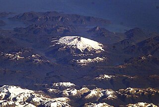
Cerro Azul, sometimes referred to as Quizapu, is an active stratovolcano in the Maule Region of central Chile, immediately south of Descabezado Grande. Part of the South Volcanic Zone of the Andes, its summit is 3,788 meters (12,428 ft) above sea level, and is capped by a summit crater that is 500 meters (1,600 ft) wide and opens to the north. Beneath the summit, the volcano features numerous scoria cones and flank vents.

<span class="mw-page-title-main">Lautaro (volcano)</span> Mountain in Chile

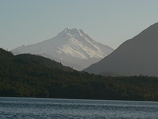
Lautaro is an active subglacial stratovolcano located in Chilean Patagonia, in the northern part of the Southern Patagonian Ice Field. Its summit rises roughly 2,400 m (7,900 ft) above the average surface of the ice cap plateau.

<span class="mw-page-title-main">Tupungatito</span> Volcano in Chile

Volcán Tupungatito is the northernmost historically active stratovolcano of the southern Andes. Part of the Chilean Andes' volcanic segment, it is the northernmost member of the Southern Volcanic Zone (SVZ), which is one of several distinct volcanic belts in the Andes. Over 70 Pleistocene or Holocene age volcanoes make up this volcanic belt, which on average has one eruption per year.

<span class="mw-page-title-main">Yanteles</span> Mountain in Chile

Yanteles is an isolated stratovolcano composed of five glacier-capped peaks along an 8 km-long NE-trending ridge. It is located approximately 30 km (19 mi) south of the Corcovado volcano in the Chilean X Region within the Corcovado National Park. The name Yanteles can refer only to the main summit, which is also known as Volcán Nevado.

<span class="mw-page-title-main">Melimoyu</span> Mountain in Chile

Melimoyu is a stratovolcano in Chile. It is an elongated volcanic complex that contains two nested calderas of 1 kilometre (0.62 mi) and 8 kilometres (5.0 mi) width. An ice cap has developed on the volcano with a couple of outlet glaciers. Melimoyu has not erupted in recent times, but during the Holocene two large eruptions took place and ejected ash at large distances from the volcano.

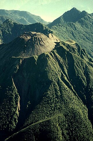
Mentolat is an ice-filled, 6 km (4 mi) wide caldera in the central portion of Magdalena Island, Aisén Province, Chilean Patagonia. This caldera sits on top of a stratovolcano which has generated lava flows and pyroclastic flows. The caldera is filled with a glacier.

<span class="mw-page-title-main">Cerro Macá</span> Mountain in Chile

Cerro Macá is a stratovolcano located to the north of the Aisén Fjord and to the east of the Moraleda Channel, in the Aysén del General Carlos Ibáñez del Campo Region of Chile. This glacier-covered volcano lies along the regional Liquiñe-Ofqui Fault Zone.

<span class="mw-page-title-main">Esjufjöll</span> Volcano in Iceland

The subglacial Esjufjöll volcano is located in the south-east part of the Vatnajökull icecap. Esjufjöll is a strict nature reserve.

<span class="mw-page-title-main">Aguilera (volcano)</span> Mountain in Chile

Aguilera is a stratovolcano in southern Chile. The volcano rises above the edge of the Southern Patagonian Ice Field. It is a remote volcano that was identified as such in 1985. The first ascent only occurred in 2014, making it the last unclimbed major Andean volcano.

<span class="mw-page-title-main">Andean Volcanic Belt</span> Volcanic belt in South America

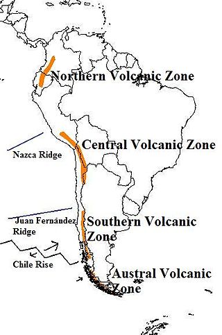
The Andean Volcanic Belt is a major volcanic belt along the Andean cordillera in Argentina, Bolivia, Chile, Colombia, Ecuador, and Peru. It is formed as a result of subduction of the Nazca Plate and Antarctic Plate underneath the South American Plate. The belt is subdivided into four main volcanic zones which are separated by volcanic gaps. The volcanoes of the belt are diverse in terms of activity style, products, and morphology. While some differences can be explained by which volcanic zone a volcano belongs to, there are significant differences within volcanic zones and even between neighboring volcanoes. Despite being a type location for calc-alkalic and subduction volcanism, the Andean Volcanic Belt has a broad range of volcano-tectonic settings, as it has rift systems and extensional zones, transpressional faults, subduction of mid-ocean ridges and seamount chains as well as a large range of crustal thicknesses and magma ascent paths and different amounts of crustal assimilations.

<span class="mw-page-title-main">Sollipulli</span> Volcanic mountain in Chile

Sollipulli is an ice-filled volcanic caldera and volcanic complex, which lies southeast of the small town of Melipeuco in the La Araucanía Region, Chile. It is part of the Southern Volcanic Zone of the Andes, one of the four volcanic belts in the Andes chain.

<span class="mw-page-title-main">Huequi</span> Mountain in Chile

Huequi is a volcano in the Los Lagos Region of Chile. It is in the Southern Volcanic Zone, in the centre of Ayacara Peninsula and close to the Gulf of Ancud. It is made up of a lava dome complex situated in a depression of unclear origin, a postglacial lava dome Calle and a Pleistocene volcano with Holocene parasitic cones, with a sharp summit at 1,318 metres (4,324 ft). There were reports of eruptions 1890–1920, and it is said to have "smoked" in 1935.

<span class="mw-page-title-main">Reclus (volcano)</span> Volcano located in the Patagonia Ice Field, Chile

Reclus, also written as Reclús, is a volcano located in the Southern Patagonian Ice Field, Chile. Part of the Austral Volcanic Zone of the Andes, its summit rises 1,000 metres (3,300 ft) above sea level and is capped by a crater about 1 kilometre (0.62 mi) wide. Close to the volcano lies the Amalia Glacier, which is actively eroding Reclus.

<span class="mw-page-title-main">Thordarhyrna</span>

Thordarhyrna is one of seven subglacial volcanoes beneath the Vatnajokull glacier in Iceland. It is a paired active central volcano with Grímsvötn, and can be classified as part of the Grímsvötn-Laki volcanic system, with common fissure swarms to the south.

<span class="mw-page-title-main">Monte Burney</span> Stratovolcano in southern Chile

Monte Burney is a volcano in southern Chile, part of its Austral Volcanic Zone which consists of six volcanoes with activity during the Quaternary. This volcanism is linked to the subduction of the Antarctic Plate beneath the South America Plate and the Scotia Plate.

Fueguino is a volcanic field in Chile. The southernmost volcano in the Andes, it lies on Tierra del Fuego's Cook Island and also extends over nearby Londonderry Island. The field is formed by lava domes, pyroclastic cones, and a crater lake.

<span class="mw-page-title-main">Pali-Aike volcanic field</span> Cluster of volcanoes in Argentina and Chile

The Pali-Aike volcanic field is a volcanic field along the Argentina–Chile border. It is part of a family of back-arc volcanoes in Patagonia, which formed from processes involving the collision of the Chile Ridge with the Peru–Chile Trench. It lies farther east than the Austral Volcanic Zone, the volcanic arc that makes up the Andean Volcanic Belt at this latitude. Pali-Aike formed over sedimentary rock of Magallanes Basin, a Jurassic-age basin starting from the late Miocene as a consequence of regional tectonic events.

<span class="mw-page-title-main">Mount Hudson</span> Mountain in Chile

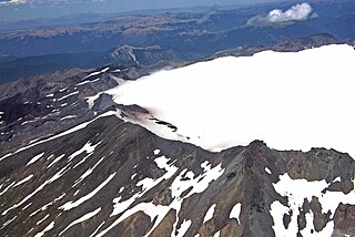
Mount Hudson is a volcano in the rugged mountains of southern Chile. Lying in the Southern Volcanic Zone of the Andes, it was formed by the subduction of the oceanic Nazca Plate under the continental South American Plate. The Nazca Plate ends there at the Chile Triple Junction; south of Hudson is a smaller volcano, followed by a long gap without active volcanoes that separates the Southern Volcanic Zone from the Austral Volcanic Zone. Hudson has the form of a 10-kilometre-wide (6-mile) volcanic caldera filled with ice. The Huemules Glacier emerges from the northwestern side of the caldera. The volcano has erupted rocks ranging from basalt to rhyolite, but large parts of the caldera are formed by non-volcanic rocks.

References

  1. 1 2 3 "Viedma". Global Volcanism Program . Smithsonian Institution . Retrieved 2005-02-15.
  2. 1 2 3 4 5 6 Kobayashi et al. 2010, p. 434.
  3. 1 2 3 Kilian 1990, p. 301.
  4. Shipton 1960, p. 393.
  5. 1 2 Perucca, Alvarado & Saez 2016, p. 552.
  6. 1 2 Perucca, Alvarado & Saez 2016, p. 553.
  7. 1 2 @SmithsonianGVP (August 15, 2019). "Global Volcanism Program" (Tweet) via Twitter.
  8. 1 2 3 Shipton 1960, p. 389.
  9. 1 2 Shipton 1960, p. 391.
  10. 1 2 Mateo, Mateo (9 December 2008). "Registro Histórico de Antecedentes Volcánicos y Sísmicos en la Patagonia Austral y la Tierra del Fuego. Historic Record of Volcanic and Seismic Precedents in Southern Patagonia and Tierra del Fuego". Magallania (in Spanish). 36 (2): 12. ISSN   0718-2244.
  11. 1 2 3 Blampied et al. 2012, p. 380.
  12. Lliboutry, Luis (1956). Nieves y glaciares de Chile: fundamentos de glaciologia (in Spanish). Ediciones de la Universidad de Chile. p. 413.
  13. Kobayashi et al. 2010, p. 436.
  14. 1 2 Kobayashi et al. 2010, p. 435.
  15. 1 2 Blampied et al. 2012, p. 381.
  16. Kilian 1990, p. 301,302.
  17. Stern, Charles R. (1 February 2008). "Holocene tephrochronology record of large explosive eruptions in the southernmost Patagonian Andes". Bulletin of Volcanology. 70 (4): 435. Bibcode:2008BVol...70..435S. doi:10.1007/s00445-007-0148-z. hdl: 10533/139124 . ISSN   0258-8900. S2CID   140710192.
  18. 1 2 3 Stern, Charles R. (2004). "Active Andean volcanism: its geologic and tectonic setting". Revista Geológica de Chile. 31 (2): 161–206. doi: 10.4067/S0716-02082004000200001 . ISSN   0716-0208.
  19. Kobayashi et al. 2010, p. 438.
  20. 1 2 Kilian 1990, p. 303.
  21. Wastegård, Stefan (November 2012). "Tephrostratigraphy of the Potrok Aike Maar Lake Sediment Sequence". Quaternary International. 279–280: 528–529. Bibcode:2012QuInt.279U.528W. doi:10.1016/j.quaint.2012.08.1843. ISSN   1040-6182.
  22. Wastegård, S.; Veres, D.; Kliem, P.; Hahn, A.; Ohlendorf, C.; Zolitschka, B. (July 2013). "Towards a late Quaternary tephrochronological framework for the southernmost part of South America – the Laguna Potrok Aike tephra record". Quaternary Science Reviews. 71: 84. Bibcode:2013QSRv...71...81W. doi:10.1016/j.quascirev.2012.10.019. ISSN   0277-3791.
  23. Markgraf, Vera; Bradbury, J. Platt; Schwalb, Antje; Burns, Stephen J.; Stern, Charles; Ariztegui, Daniel; Gilli, Adrian; Anselmetti, Flavio S.; Stine, Scott; Maidana, Nora (27 July 2016). "Holocene palaeoclimates of southern Patagonia: limnological and environmental history of Lago Cardiel, Argentina". The Holocene. 13 (4): 583. doi:10.1191/0959683603hl648rp. ISSN   0959-6836. S2CID   129856246.
  24. Kilian 1990, p. 302.
  25. Perucca, Alvarado & Saez 2016, p. 557.
  26. Garcia, Sebastian; Badi, Gabriela (1 November 2021). "Towards the development of the first permanent volcano observatory in Argentina". Volcanica. 4 (S1): 26. doi: 10.30909/vol.04.S1.2148 . ISSN   2610-3540.

Sources