Tierra del Fuego is an archipelago off the southernmost tip of the South American mainland, across the Strait of Magellan.

Isla de los Estados is an Argentine island that lies 29 kilometres (18 mi) off the eastern extremity of Tierra del Fuego, from which it is separated by the Le Maire Strait. It was named after the Netherlands States-General, the Dutch parliament.

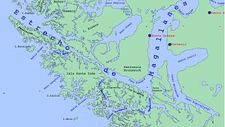
The Strait of Magellan, also called the Straits of Magellan, is a navigable sea route in southern Chile separating mainland South America to the north and Tierra del Fuego to the south. The strait is considered the most important natural passage between the Atlantic and Pacific oceans. The strait is approximately 570 km long and 2 km wide at its narrowest point. In 1520, the Spanish expedition of the Portuguese navigator Ferdinand Magellan, after whom the strait is named, became the first Europeans to discover it.

Ushuaia is the capital of Tierra del Fuego, Antártida e Islas del Atlántico Sur Province, Argentina. With a population of 82,615 and a location below the 54th parallel south latitude, Ushuaia claims the title of world's southernmost city.

Tierra del Fuego, officially the Province of Tierra del Fuego, Antarctica and South Atlantic Islands, is the southernmost, smallest, and least populous Argentine province. The provincial capital city is Ushuaia, from a native word meaning "bay towards the end".

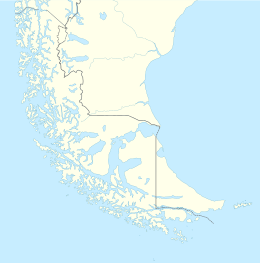
Isla Grande de Tierra del Fuego also formerly Isla de Xátiva is an island near the southern tip of South America from which it is separated by the Strait of Magellan. The western portion (61.4%) of the island is in Chile, while the eastern portion is in Argentina. It forms the major landmass in an extended group of islands or archipelago also known as Tierra del Fuego.

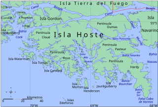
Beagle Channel is a strait in the Tierra del Fuego Archipelago, on the extreme southern tip of South America between Chile and Argentina. The channel separates the larger main island of Isla Grande de Tierra del Fuego from various smaller islands including the islands of Picton, Lennox and Nueva; Navarino; Hoste; Londonderry; and Stewart. The channel's eastern area forms part of the border between Chile and Argentina and the western area is entirely within Chile.

The Selk'nam, also known as the Onawo or Ona people, are an indigenous people in the Patagonian region of southern Argentina and Chile, including the Tierra del Fuego islands. They were one of the last native groups in South America to be encountered by migrant Europeans in the late 19th century. In the mid-19th century, there were about 4,000 Selk'nam; in 1916 Charles W. Furlong estimated there were about 800 Selk'nam living in Tierra del Fuego; with Walter Gardini stating that by 1919 there were 279, and by 1930 just over 100.

The Yahgan are a group of indigenous peoples in the Southern Cone of South America. Their traditional territory includes the islands south of Isla Grande de Tierra del Fuego, extending their presence into Cape Horn, making them the world's southernmost human population.
Tierra del Fuego Province is one of four provinces in the southern Chilean region of Magallanes and Antártica Chilena (XII). It includes the Chilean or western part of the main island of Tierra del Fuego, except for the part south of the Cordillera Darwin, which is in Antártica Chilena Province.
Almirantazgo Fjord, also known as Almirantazgo Sound or Admiralty Sound, is a Chilean fjord located in the far south of the country at 54°19′S69°30′W. The fjord cuts deeply into the west coast of the Isla Grande de Tierra del Fuego, extending southeastwards from the Whiteside Channel, which separates Isla Grande from Dawson Island. On its south side several smaller fjords and bays make significant indentations into the north coastline of the Cordillera Darwin. One of these, Ainsworth Bay, is home to a colony of elephant seals. Azopardo River empties into the head of the fjord.

Nothofagus betuloides, Magellan's beech or guindo, is a tree native to southern Patagonia.
The South American Mission Society was founded at Brighton in 1844 as the Patagonian Mission. Captain Allen Gardiner, R.N., was the first secretary. The name "Patagonian Mission" was retained for twenty years, when the new title was adopted. The name of the organisation was changed after the death of Captain Gardiner, who died of starvation in 1851 on Picton Island in South America, waiting for a supply ship from England. Gardiner thought that the original mission should be expanded from southern South America (Patagonia) to all of South America. Charles Darwin is reported to have supported the society financially and rhetorically.
Bahía Buen Suceso is a small bay in Argentina's Tierra del Fuego province. It is known in English as Bay of Good Success, Bay of Success and Success Bay. It is located on the western shore of Le Maire Strait, which separates Tierra del Fuego and Isla de los Estados.

Tierra del Fuego National Park is a national park on the Argentine part of the island of Tierra del Fuego, within Tierra del Fuego Province in the ecoregion of Patagonic Forest and Altos Andes, a part of the subantarctic forest. Established on 15 October 1960 under the Law 15.554 and expanded in 1966, it was the first shoreline national park to be established in Argentina.
Bahía Cook, also known in English as Cook Bay, is an irregular bay located between Londonderry Island, Hoste Island, Olga Island and Gordon Island southwest of Tierra del Fuego in Chile.

Between 1883 and 1906 Tierra del Fuego experienced a gold rush attracting many Chileans, Argentines and Europeans to the archipelago, including many Dalmatians. The gold rush led to the formation of the first towns in the archipelago and fueled economic growth in Punta Arenas. After the gold rush was over, most gold miners left the archipelago, while the remaining settlers engaged in sheep farming and fishing. The rush made a major contribution to the genocide of the indigenous Selk'nam people.

The Argentina–Chile border is the longest international border of South America and the third longest in the world after the Canada–United States border and the Kazakhstan–Russia border. With a length of 5,308 kilometres (3,298 mi), it separates Argentina from Chile along the Andes and on the islands of Tierra del Fuego. However, there are some border disputes, particularly around the Southern Patagonian Ice Field. It is the largest border of the two countries, beating the Argentina–Paraguay and Chile–Bolivia, Argentina's and Chile's second largest borders, respectively.
Fueguino is a volcanic field in Chile. The southernmost volcano in the Andes, it lies on Tierra del Fuego's Cook Island and also extends over nearby Londonderry Island. The field is formed by lava domes, pyroclastic cones, and a crater lake.